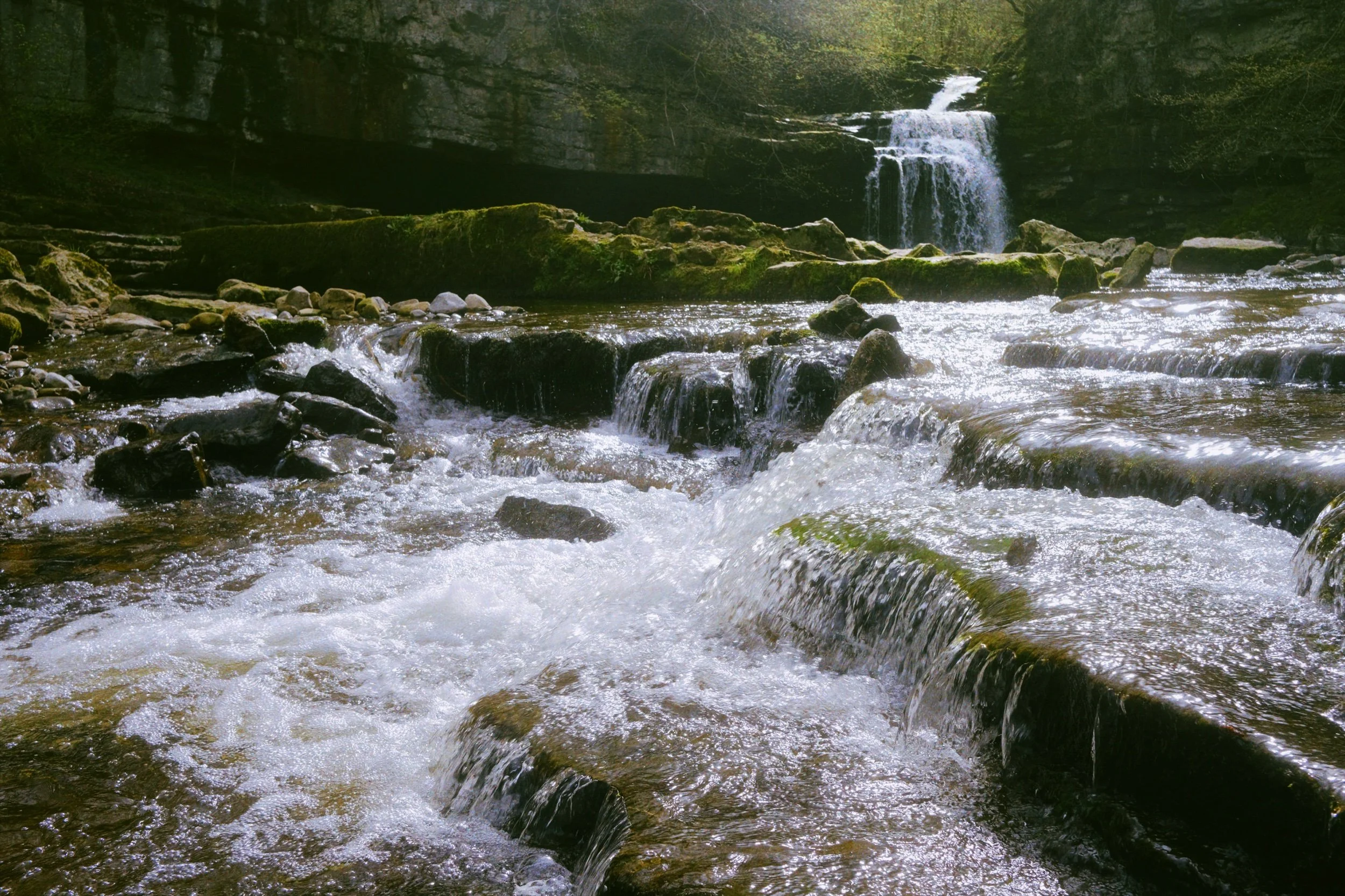
West Burton Falls, Yorkshire Dales, Spring
Another Yorkshire Dales waterfall ticked off.
Another Yorkshire Dales waterfall ticked off.
On the way back from our weekend at Pateley Bridge, where we scrambled up Trollers Gill and explored Almscliffe Crag, we decided no the scenic route right through the centre of the Yorkshire Dales National Park.
From Pateley Bridge this involves driving through Upper Wharfedale and scaling the gap between Buckden Pike and Yockenthwaite Moor, before dropping down into Bishopdale and joining the A685 west at Aysgarth.
Before the main road, though, we decided to stop at West Burton, a small and beautiful village. Scenes of a pristine Yorkshire Dales village are available in every direction, featuring a large village green, aged limestone buildings, and friendly residents.
Even better, not 5-minutes walk from the village green, one can find and explore the stunning Cauldron Falls, also known as West Burton Falls.
All photo shot on my Fujifilm X-T2 using two of my prime lenses: the Fujinon 23mm f/2.0, and an adapted Pentax SMC 55mm f/2.0. Images developed using RNI Films' Portra 400 film profile.
Even after a dry spell there was still plenty of water flowing over the falls.
From the other side of the gorge that the waterfall had carved out, it's possible to navigate across some rocks to get right in the middle of the gorge.
It's easy to see these falls are called Cauldron Falls, as millennia of erosion by the waterfall has created a natural bowl of an amphitheatre.
No Yorkshire Dales beck would be complete without a beautiful and ancient stone packhorse bridge.
I navigated as close to the waterfall as the slippery rocks allowed.
Back at the village green, father and son enjoy a kickabout.
The fells of Bishopdale and Walden Moor embrace the village in a comforting hug.
The beautifully manicured village green runs alongside the Main Street through the village. In the distance are the Wensleydale fells.
There were some gorgeous old Yorkshire Dales cottages to gawp at around the green.
A proper cosy and sleepy little place.
Gotta have a local pub in a Yorkshire Dales village.
A crackin' way to cap off the Easter weekend.
Trollers Gill & Parcevall Hall, Yorkshire Dales, Spring
Happy belated Easter everyone. Did you have a good 'un?
Happy belated Easter everyone. Did you have a good 'un?
Usually for Cumbria, and the Lake District in particular, Easter signals the first tourism wave of the season. With that in mind, and no obligations to serve, Lisabet and I booked a couple of nights away in a beautiful B&B set in bonny Pateley Bridge, in the Nidderdale Area of Outstanding Natural Beauty.
We took the scenic route to Nidderdale from Cumbria, as we didn't need to check in until the evening. So, first we stopped off at the impossibly pretty Yorkshire Dales village of Burnsall for lunch and some light photography. Afterwards we continued east and stopped off near Grimwith Reservoir for the day's main activity: Trollers Gill.
This place has been on my radar, otherwise known as my Pinterest, for years.
It did not disappoint.
All photos shot on my Fujifilm X-T2 using my three prime lenses: a Fujinon 23mm f/2.0, a Laowa 9mm f/2.8, and an adapted Pentax SMC 55mm f/2.0. Images made 80% in-camera using the Astia film simulation, then finished off in Lightroom and Affinity Photo.
Burnsall
After coffee and a bacon butty near the river, we snapped some shots of Burnsall as we made our merry way back to the car. The 5-arched Burnsall Bridge here is a Grade II listed building, originally constructed in the 17th century with some 19th century improvements.
I'm not sure it's possible to get more Yorkshire than this scene. The Red Lion, built in the 16th century, and recently taken over by Thwaites Brewery.
Like many Yorkshire Dales villages, there's plenty of historical sandy limestone buildings decorated with beautiful greenery, flowers, and the distant hills.
Burnsall Primary School. Originally the old Grammar School founded in 1602 by William Craven of Appletreewick, who later became Lord Mayor of London.
Trollers Gill
After Burnsall, I identified a handy little parking area off the B6265 that would serve as the starting point of our hike to, and up, Trollers Gill. The day was bright and sunny whilst also hazy, lending a wonderful sense of intrigue and distance to photographs. Up on the moorland high above Appletreewick, views extended for miles and miles.
The path down the moorland was easy enough to follow, and soon the characteristic karst limestone landscape of the Yorkshire Dales became apparent.
The main signs pointing to Trollers Gill invite walkers to enter the ravine at the top and scramble their way down. Instead, we elected to take the trail around the western side of Middle Fell. This would eventually lead us to the bottom of Trollers Gill.
The anticipation and excitement builds as we near the bottom of the deep ravine.

At the bottom of Trollerdale, we followed the minor path north to start the climb up Trollers Gill. But first, I simply had to snap this glorious scene.
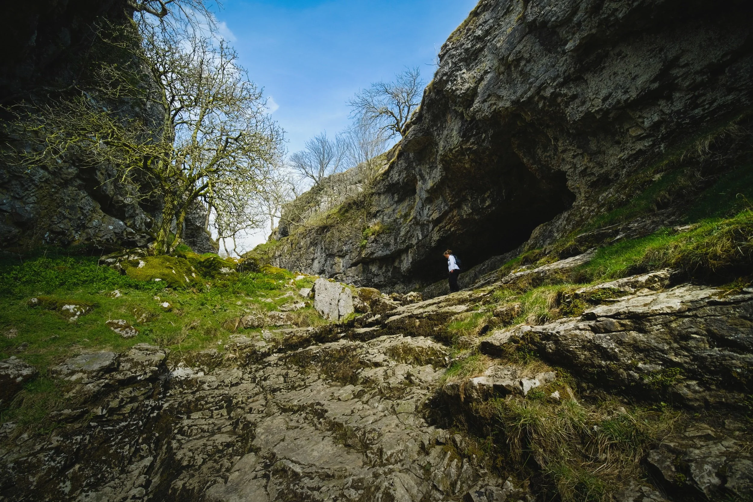
The entrance to Trollers Gill, largely dry for most of the year. Historically this would've been the site of a thunderous ravine with several waterfalls and cascades crashing down the gill. Thousands of years of erosion in a limestone landscape means the beck at the top of the gill now goes underground before entering the ravine, later reemerging at the bottom of Trollerdale.
Looking back at our way into Trollers Gill. Fellow hikers gingerly navigate the way down the ravine. Can you imagine this gorge full of water?
As with many other places in the Yorkshire Dales that features sheer limestone walls, Trollers Gill is a favourite for rock climbers.
Rock climbers assist each other as they ascertain routes up the sheer sides of Trollers Gill.
An ultra wide composition looking up from the bottom of what would've been a powerful waterfall. The meaning of the name "Trollers Gill" comes in two parts. "Gill" is already quite well known and used in Yorkshire and Cumbria, sometimes alternatively spelled as "Ghyll". It means a deep ravine or gully, and is cognate with the word gullet. "Trollers" is split into two: "troll" meaning, well, troll, the mythical beast (not the internet variety), and ears meaning "arse". This gives us "the Troll's arse". You're welcome.
Near the top of Trollers Gill, where the beck mysteriously disappears into the unfathomably twisted caves underneath.
Climbing out the gill and up onto the moorland, we realise that the haze has nearly cleared, giving us a fairly clear shot of Simon's Seat.
The deep drop into Trollers Gill that we had just climbed out of.
The single lane "New Road" that connects with the B6265.
A clear sign that a moorland is particularly and consistently wet: rushes everywhere.
One last look back at the farm track that guided us down into Trollers Gill.
A great discovery! Hanging on a branch near our parking spot was this beautifully preserved sheep's skull, probably a Swaledale. We took it home. Isn't it beautiful?
Parcevall Hall & Gardens
After returning to the car, we realised looking at the map that we were very near Parcevall Hall & Gardens. Fancy a quick visit and a wander? Why not?
Parcevall Hall is a Grade II listed Manor House that includes 24 acres of sculpted and maintained gardens. They were created in 1927 but fell into decline after 1960 following the death of Sir William Milner, 8th Baronet of Nun Appleton. Restoration work commenced in the 1980s.

People can visit and explore the gardens between April and October. It enjoys fabulous views and beautiful displays.
Lisabet and I particularly enjoyed this peaceful statue.
The Gardens, amongst other things, are known for their wonderful view of Trollers Gill, so we followed the route uphill.
Still plenty of daffodils around.
And there it is. Trollers Gill to the right and Middle Fell in the centre, daffodils blooming below. What a fantastic scene.
Cherry Blossom in full bloom at the entrance to the Gardens. What a full and gorgeous day.

Kirkoswald, Cumbria, Winter
Welcome to the ancient village of Kirkoswald.
Welcome to the ancient village of Kirkoswald.
The day ahead looked to be rather changeable, with unpredictable downpours combined with gusty winds. Our best bet was to head to Northern Cumbria. So why not spend a day with Dad?
We all ventured to Kirkoswald for a gentle stroll around the area. The village is timeworn, with many buildings still standing since the 1600s and 1700s. Even older—to the south of the village—is St. Oswald’s Church, with parts of it dating back to the 12th century. The church is, in fact, where the village gets its name: “Kirk” is the Old Norse word for “church”. It is thought that the body of Saint Oswald, King of Northumbria, was taken through the village.
Southwest of the village is Eden Bridge, a beautiful red sandstone construction. It dates from 1762, with repairs made in the 19th and 20th centuries.
Thankfully the day was largely cooperative, weather-wise, and we all enjoyed some lovely photography walking around this ancient parish.
All photos shot on my Fujifilm X-T2 using my three prime lenses: a Fujinon 23mm f/2.0, a Laowa 9mm f/2.8, and an adapted Pentax SMC 55mm f/2.0. All images 95% made in-camera using Øyvind Nordhagen’s Modern Documentary Fujifilm recipe, with cropping and framing in Pixelmator and Darkroom.
My Dad’s lovely little farm cottage, in the middle of nowhere of Northern Cumbria.
The road that passes by Dad’s cottage.
Dad set up a load of bird feeders outside the cottage, home to many species that he’s always happy to take photos of.
We parked at a small car park just before the Lazonby Eden Bridge. This signalled the start of our walk into Kirkoswald. The River Eden was rather high and fast.
On the Kirkoswald side of the main bridge that spans the River Eden are these “dry arches” that were, nevertheless, flooded.
She’s a beaut of an 18th century bridge.
I whipped on my 9mm ultra wide lens to capture the whole span of the bridge as well as the lovely cloud textures that were forming.
One last look back along the entire span of the bridge before carrying on towards Kirkoswald.
Evidence of Storm Arwen’s vengeance on trees across the UK.
We took the permissive footpath from Eden Bridge into Kirkoswald, then through the church gate to follow the old cobbled path towards St. Oswald’s Church.
The church is in a beautiful setting.
There she is, St. Oswald’s Church. The building’s unique in having a 19th-century bell tower on top of a hill 200 yards from the church itself.
The main entrance to the church. Historic England specifies this timber frame thus: “North timber-framed gabled porch of c1523”. So 500-years old.
Small, and old, but humble.
People are still buried in this church’s graveyard. I spotted a gravestone for January 2021. I’m sure there are conditions/restrictions that need to be satisfied for burial here.
Love the wrought iron works around the churchyard.
A rather grand entrance to an estate of some sort.
Crossing over the small bridge that spans Raven Beck. Ancient red sandstone buildings everywhere.
Not sure what these folk were doing along the shores of the beck… but I had to snap them.
One of many buildings in Kirkoswald dating from the 18th century. This one’s datestone reads 1713.
The Crown Inn, still very much in operation. It’s an old coaching inn, again from the 18th century.
On t’other side of t’road, Lisabet inspects the menu for the Featherston Arms.
Love old buildings that are wrapped in branches and vines.
Victorian-era road signage, which still references Cumberland County Council.
Out of the top of Kirkoswald, the views across the Eden Valley are extensive.
The village square. Kirkoswald gained a Market Charter in the 13th century, and hosted markets at the village square for centuries. This then moved to the Lazonby and Kirkoswald Railway Station after the opening of the Settle–Carlisle line in 1876.
Heading back to Eden Bridge via the permissive footpath, I spy a simple composition as the storm clouds build up above.
A high and fast-flowing River Eden from the top of Eden Bridge.
St. Abbs Head, Scottish Borders, Scotland
I’m back from a week away! How’s everyone been?
I’m back from a week away! How’s everyone been?
Lisabet and I took a week’s summer break, based in a small farm cottage not too far from Berwick-upon-Tweed, Northumberland. We enjoyed lots of hiking this holiday, and as this is Northumberland and the Scottish Borders, that meant plenty of coastal action, beaches, cliffs, the lot.
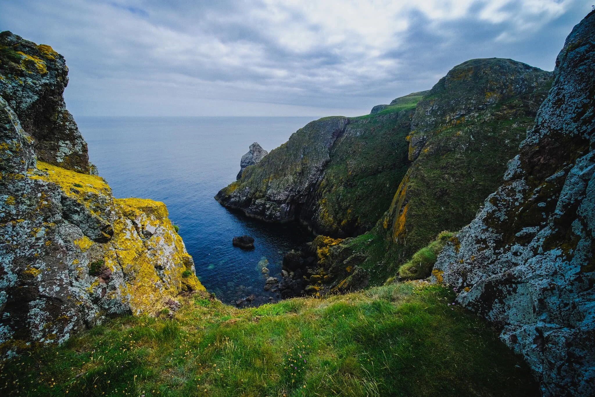
First, welcome to St. Abb’s Head in the Scottish Borders. A 30-minute drive from Berwick-upon-Tweed in England, the coastline of the Scottish Borders can often be missed or ignored by the bigger pull of the likes of Edinburgh and East Lothian. However, the coastline and cliffs of St. Abb’s Head are world class and demand a solid exploration and inspection.
St. Abb’s Head is a headland of cliffs, steep gullies, and sea stacks lying north of the village of St. Abb’s. The rock here is of volcanic origin, compared to the surrounding area’s softer sandstone. With eons of pummelling from wind and sea, this has left a coastline of twisted and contorted rocks, sheer 200ft cliff faces, and isolated islands and sea stacks.
All of this also makes the area perfect for seabirds. St. Abb’s Head is home to a seabird colony of 60,000, essentially making the whole area a City of Birds. Here one can find guillemots, razorbills, kittiwakes, fulmars, shags, herring gulls, and puffins. At times, the noise from all the birds is deafening.
We could not have asked for better conditions to hike St. Abb’s Head. After days of either rain or sea haars, it was refreshing to have a clear atmosphere, soft summer light, and a gentle breeze.
Please enjoy my photos of some of Scotland’s most epic coastline.
Photos taken on my Fujifilm X-T2 using my three prime lenses: a Samyang 35mm f/1.2, a Laowa 9mm f/2.8, and an adapted Pentax SMC 55mm f/2.0 lenses. All images were made 80% in-camera using a customised Velvia film simulation, with minor edits afterwards in Lightroom and Affinity Photo.
Just up the road from the National Trust for Scotland car park, the land above St. Abb’s head is perfect for arable farming. This scene immediately put me in mind of the famous Windows XP wallpaper, so I made an attempt at a homage to that iconic image.
The footpath away from the village quickly gains height, and the views back to St. Abb’s immediately open up. The sun broke through the clouds briefly, highlighting the cliffs of the village and rendering this scene with an almost improbable painterly quality.
A more… unusual composition of the village. Here I nestled next to the cliff edge to get these flowers in the bottom of the photo, followed by the sheer cliff face known as White Heugh, then the village in the distance. I then waited for any of the sea birds to fly into view before pressing the shutter.
Although I’ve been to St. Abb’s Head a few times now, I’ve never visited in the peak of summer. What I didn’t expect was the sheer variety and colour of all the flora around the cliffs. Astounding! Here’s the view looking straight down from above Wuddy Rocks towards White Heugh cliff and the distant village of St. Abb’s.
Onward from Wuddy Rocks, we aim towards the main headland of St. Abb’s Head itself. The shadows of clouds glide across the golden farmland below.
At Horsecastle Bay, this scene presents itself to us. In fact, as it came into view, Lisabet heard me mutter, “Oh, fuck off!” Wildflowers adorn the cliff edge, framing the various rocks in the bay and the curious boot-shaped red sea stack.
Further around Horsecastle Bay, Lisabet follows a solitary spur, which slightly spooks the birds nesting below. A pick my composition and wait for all the elements to align.
The southeastern cliffs of St. Abb’s Head is known as Kirk Hill, and features a variety of geological “uncomformities”; that is, layers of rock from vastly different ages in history, lying next to each other.
As we climb up St. Abb’s Head, the lighthouse comes into view. We hang around the cliff edges above Clafferts Rock for some compositions involving the lighthouse.
Beyond the lighthouse, the cliffs get steeper and more vertical. Lisabet follows one spur alone. Click/tap the image for a bigger view; you may well be able to point out the hundreds of birds on the cliffs to the left.
I clambered down the cliffs beneath the lighthouse for a view looking back towards it.
It’s hard to do justice to the sheer scale of these cliffs and how far they drop to the North Sea below. Also, not pictured, is the deafening sound of thousands of seabirds shouting at each other.
The cliff edges were covered in a wide variety of summer flora.
Other hikers follow the cliff edge trail, and as I line up a composition of the cliffs of St. Abb’s Head, I deliberately include the people to help provide a sense of scale.
With my ultra-wide 9mm lens, I was able to capture images looking almost vertically down to the sea from the cliff edges as well as the horizon. A scene of pure drama, with sheer cliffs and finned sea stacks covered in guano.
Lisabet and I find a grassy opening framed by two towers that provides me with this wonderful composition of St. Abb’s Head and the North Sea beyond.
Further northeast along St. Abb’s Head, I follow a spur out near the ruins of St. Abb’s Nunnery, which enables me to view this open panorama of the sheer cliffs and St. Abb’s Lighthouse.
Lisabet and I get more adventurous and follow this particular spur all the way down and out towards the edge. I lay down and nab this composition looking back up to the sea stacks, the cliffs, and the lighthouse, all in one.
Towards West Hurker the geology gets even more insane, if that’s at all possible. In the distance we can start to see the cliffs of Uilystrand Brae.
The cliff edges here get more erratic, now featuring individual towers and pillars that provide small openings and sheer drops to the sea below.
Don’t look down…
Towards the edge of West Hurker, the northwestern part of St. Abb’s Head, the path becomes gentler as the cliffs of Uilystrand Brae grow in stature.
To get a better view of the Uilystrand Brae cliffs, we elect to follow the steep grassy path down to Pettico Wick Bay, with the views getting more epic along the way. Check out the wee little hikers in the bottom-left of the frame!
And there it is. Pettico Wick Bay and the twisted cliffs of Uilystrand Brae on a perfect summer’s day.
Bowscale Tarn, Lake District, Summer
We kicked off Father’s Day weekend by revisiting the Mosedale valley in the Northern Fells of the Lake District.
We kicked off Father’s Day weekend by revisiting the Mosedale valley in the Northern Fells of the Lake District.
The last time we hiked Mosedale was back in March of this year, during a visit to my Dad’s. It was our first time in this quiet valley and we were floored with the sights and views. The nice weather probably helped.
This time we endeavoured to hike the public bridleway up Mosedale’s southern side. Following this takes you all the way to Bowscale Tarn and, if you want, onwards up to Bowscale Fell (702 m/2,303 ft). Adventurous fell walkers can then extend this hike by venturing further south to summit Blencathra itself (868 m/2,848 ft).
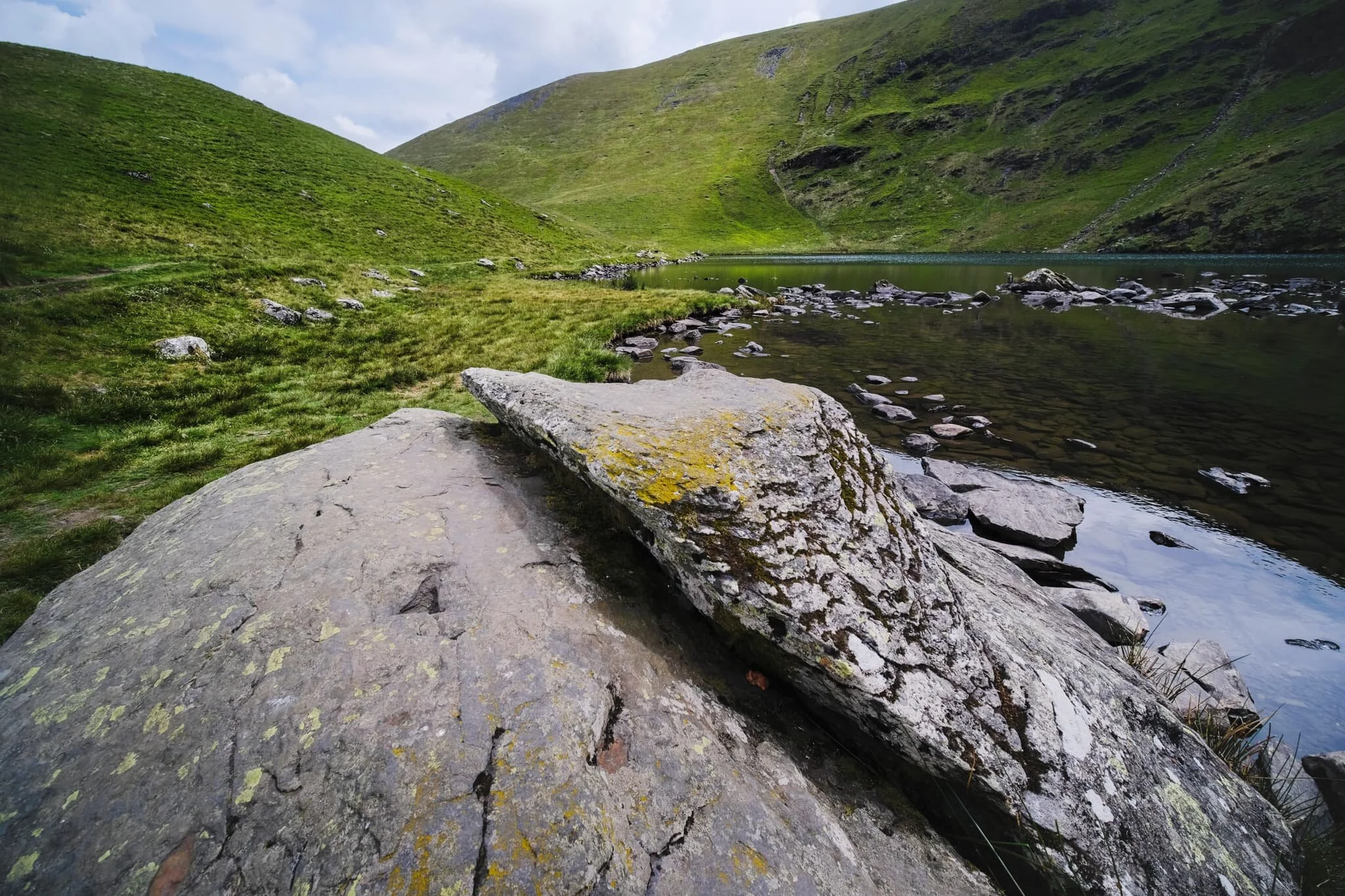
We decided not to summit Bowscale Fell this time round; the humidity was proving quite draining. Nevertheless, Bowscale Tarn was delightful. It’s flanked on all sides except the north by sheer walls of crag. The tarn is reportedly 60 ft deep and—so the legend goes—is home to a pair of talking, immortal fish.
The more you know!
All photos shot on my Fujifilm X-T2 using my three prime lenses: a Samyang 35mm f/1.2, a Laowa 9mm f/2.8, and an adapted Pentax SMC 55mm f/2.0. Images 80% developed in-camera using a customised Provia film simulation, with minor finishing edits in Lightroom and Affinity Photo.
After parking up at the small car park, generously provided by the Quaker Meeting Hall, I had to quickly snap this photo. It’s such an English Lake District village scene.
Tiny Mosedale village, nestled underneath Carrock Fell (661 m/2,169 ft).
Onto the public bridleway near Bowscale hamlet and up we go! We certainly weren’t the only ones on this trail, and nor should we expect to be given it’s summer in the Lake District. Nevertheless, this part of the national park definitely sees fewer visitors.
The flat-bottomed floor of Mosedale, perfectly sculpted by historical glaciers.
Looking back, I spot Lisabet nabbing a photo of a bee on some thistle. The cloudy conditions increased the humidity of the day, and soon we were rather damp in sweat.
Plenty of Swaledale ewes about in Mosedale, with their spring lambs getting to know the valley and the fells.
Around this part of the bridleway, the gradient starts to increase as we near Bowscale Tarn. I paused to catch me breath briefly, and looked back to shoot the light scanning across the shoulder of Bowscale Fell.
Bowscale Tarn is near. The bridleway skirts around this moraine “lip” that keeps the water where it is. Ahead is the wall known sensibly as Tarn Crags.
We made it to the tarn, preceded by fellow hikers and families enjoying the delights of nature.
An unnamed gill cuts through the crags of Bowscale Fell and drops into the deep and dark water of Bowscale Tarn.
Near the outflow of the tarn, which drops to the valley floor as Tarn Sikes, one can find some impressive boulders offering compositional interest.
A wider view of Bowscale Tarn, surrounded by Tarn Crags. The summit of Bowscale Fell is just up and to the left.
Lisabet and I gingerly navigated around the shore of the tarn, picking out photos along the way. Underneath Tarn Crags, I looked back to the outflow of the tarn and made this composition incorporating the distant summit of Carrock Fell.
Even on the steep slopes of Tarn Crags, you’ll find ewes and their lambs.
This part of the shoreline marks the end of our way around the tarn. A brief opening in the clouds above softly illuminates the scene.
There were plenty of kids hopping, skipping, and jumping around the rocks and boulders of the tarn.
After pausing for lunch, it was time to head back down. I equipped my 55mm lens for some longer perspectives, including this one of Lisabet and the northern side of Mosedale.
Salutations to the splendour of nature? Or stretching her shoulders and back out?
After following the clear, yet admittedly steep, path directly back down to the valley floor, we paused at the footbridge to admire this view all the way back up Mosedale.
Roundhouse Farm marks the point where we join the path on the northern side of Mosedale and head back east to the car. The earliest parts of the farm date back to 1702 AD.
Swaledales were being smart and sought shelter from the sun underneath the trees and in the shade of the drystone walls. They look about ready for a good clipping (shearing).
Behold! Some blue sky at last!
The full extent of Mosedale from near the village. What a crackin’ day.

Askham Fell, Lowther, Cumbria, Spring
Everything is starting to look proper lush.
Everything is starting to look proper lush.
After a completely washed out Saturday, today looked significantly more promising. Lisabet had found a 7.5-mile circular hike around the Lowther Estate that utilises a section of the Ullswater Way, so that’s what we did.
The walk starts at Lowther Castle and heads southwest down to the River Lowther, skirting around the tiny village of Helton and hiking west up Askham Fell. Near the summit you turn northeast and down to Askham village, over the river again, and back up the castle. Nowt particularly gruelling but a good variety of scenery, historical interest, and views for miles and miles.
We managed to avoid the rain, too.
All photos shot on my Fujifilm X-T2 using my three prime lenses: a Samyang 35mm f/1.2, a Laowa 9mm f/2.8, and an adapted Pentax SMC 55mm f/2.0. Images are largely straight-out-of-camera using Fuji X Weekly’s “Ektachrome 100SW” recipe, with a couple of minor tweaks in Lightroom and Affinity Photo.
This is Lowther Castle. The roof has been removed and much of the stonework demolished, leaving the “shell” of the castle—technically a country house—intact with lots of plants and vegetation allowed to grow within.
Some of the gatehouses have been left alone, offering this interesting composition involving the castle ruins. Just a shame about the gate.
We crossed the River Lowther here, heading vaguely in the direction of Helton. In the far distance are the “backends” of the eastern Ullswater fells.
This gorgeous lane takes you up and through the fields towards Helton. Hemmed in with dry stone walls and lined with old trees and plenty of flowering plants.
A seriously pretty lane. It may well have been used, in times gone by, to guide livestock between fields for grazing.
On the outskirts of Helton, a cute pony had zero interest in our offers of friendship. Fair enough.
Helton village towards the left. A scene of English rural idyll.
A rather fine solitary tree that I head to feature in a composition, especially with the dry stone walls as leading lines.
Heading west, this is the track heading up to Askham Fell (323 m/1,059 ft), lined with drystone walls.
My lovely Lisabet, with the expansive view behind.
This is the Cop Stone, a standing stone located near the Moor Divock stone circle on Askham Fell. A prehistoric monument, it’s reason for being lost in time. In the distance is the unmistakeable wall of the Northern Pennines.
Heading back down Askham Fell.
Askham village ahead, with the shadows of Northern Pennines looming above in the distance. The village is rather beautiful, and features a large share of houses and buildings many centuries old.
A rather beautiful old barn.
Just one of many houses in Askham that are many centuries. It kinda blows my mind that this house was built before the founding of the United States of America.
The woods underneath Lowther Castle contains a variety of rather unusual looking trees.