
Hull Pot, Yorkshire Dales, Winter
A month since my last post.
A month since my last post.
I do apologise.
The weather in January has been, well, shocking to say the least. We endured three named storms: Henk, Isha, and Jocelyn. Isha, in particular, was one of the most powerful storms the British Isles have seen since 2000.
Additionally, we’ve had periods of below freezing temperatures, resulting in widespread ice.
It’s been… interesting.
Thankfully, the weekend just gone, it was nice enough for us to finally head out. We chose the Hull Pot route from Horton-in-Ribblesdale in the Yorkshire Dales. I had an inkling that there’d still be some snow liggin’ about in the Dales, contributing to a water-saturated landscape and, hopefully, a waterfall flowing into Hull Pot.
And we finally saw it.
All photos taken on my Sony α7ii using my Pentax SMC 28mm F3.5, Pentax SMC 55mm f2.0, and Rokinon 14mm f2.8 ED AS IF UMC prime lenses. RAWs developed in Lightroom, edited and finalised in Photoshop.
Hull Pot, Yorkshire Dales, Winter by Ian Cylkowski is licensed under CC BY-NC-SA 4.0![]()
![]()
![]()
![]()
The characteristic drystone walls of the Yorkshire Dales remained steadfast in the face of all the snow we’ve had recently, resulting in these snowdrifts piled up against them.
Our way forward. We knew on this day that there’d only be 2-3 hours of good light, and boy was it dramatic.
Looking back at where we came from. We were very much on the edge of two weather systems. Conditions over Horton-in-Ribblesdale saw blue skies and puffy clouds, but closer to Pen-y-Ghent it was blowy, dark, and stormy, giving us epic light.
A good sign: A small waterfall where there usually isn’t at Horton Scar. Above, Pen-y-Ghent fights with the dark and stormy clouds.
Further up the bridleway, the site of an extinct waterfall below Pen-y-Ghent, which is now obscured by clouds laden with snow. A burst of sun to our right picks out the details in the land.
And there she is, finally ticked off my bucket list. England’s largest natural hole, Hull Pot, with Hull Pot Beck tumbling down 60ft into the chasm. As mentioned before on this blog, Hull Pot is a large cave where the roof has collapsed, which has resulted in this massive chasm below Pen-y-Ghent. With my ultra-wide 14mm equipped, I was able to capture the entire scene.
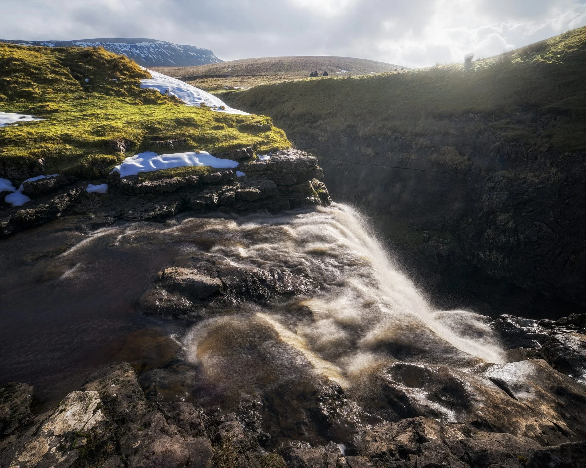
We clambered as close to the waterfall as possible as it crashed over the edge into Hull Pot. As I had no tripod, I shot this with my ultra-wide 14mm at f/22, taking multiple exposures of the same scene. In post, I then averaged the exposures together that gave me that long exposure effect on the water.
Looking up Hull Pot Beck and its many cascades. By the normal way of things, this beck is dry as it usually disappears into the maze of caves beneath Pen-y-Ghent before it reaches Hull Pot. With all the rain and snow we’ve had, the beck was able to complete its route, crashing 60ft down into Hull Pot and re-emerging at the surface nearer Horton-in-Ribblesdale.
A different view of Hull Pot from its eastern end. Two boulders balance precariously on the lip of the pot.
At around 450 m/1,476 ft above sea level, a few snow patches have lingered around the edges of Hull Pot, allowing for some interesting compositional leading lines.
A particularly clean snow patch nearer the falls gives me an idea for a composition involving Pen-y-Ghent in the distance. Fellow hikers milling about the edge of Hull Pot give you a sense of scale of this place.
Heading back down to the village, signs were clear that the best of the day’s light were done as the storm clouds rolled in. We were thankful to get what we did, though.
Did you enjoy these photos?
Grassington, Yorkshire Dales, Autumn
Autumn is coming.
Autumn is coming.
Knowing that yet more rain was on its way in the afternoon, and that our best chances were further east, we elected to head into the Yorkshire Dales. Here we embarked on a nice 10 km hike, taking in the epic Linton Falls, timeless Grassington, and Grass Wood Nature Reserve.
While there were certainly hints of autumn colours, it seems we need another couple of weeks around our latitude before they reach peak conditions. That’s assuming, of course, that the weather cooperates and doesn’t just blow all the leaves straight off the trees.
Although strictly speaking a town, Grassington has a wonderfully timeless Yorkshire village vibe. As a result, it was selected as the primary location for the 2020 reboot of All Creatures Great and Small, playing the role of the fictional Yorkshire town of Darrowby.
All photos shot on my Sony α7ii using my Sony FE 28–70mm f3.5–5.6 OSS zoom lens. RAWs were largely developed using Capture One for iPad, and finalised using Lightroom for iPad and Darkroom for iPad.
Grassington, Yorkshire Dales, Autumn by Ian Cylkowski is licensed under CC BY-NC-SA 4.0![]()
![]()
![]()
![]()
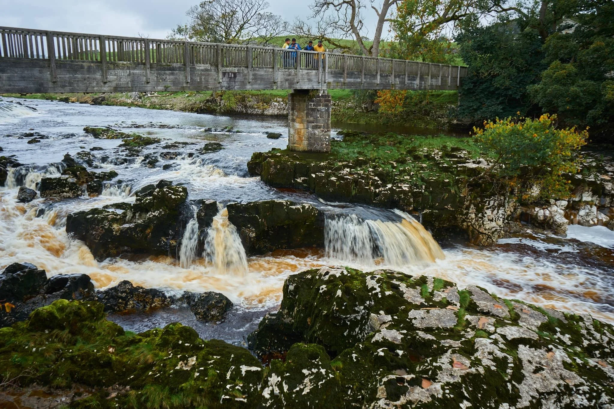
Linton Falls, a series of powerful cascades crashing over a limestone fault in the River Wharfe.
Just above the falls are a couple of weirs that sweep across the river, disrupting the flow of water so as not to sweep away at the river bank so much.

My Lisabet on the footbridge above the thundering falls. It’s quite the drop and a somewhat unnerving sensation.
From the footbridge looking down, it’s easy to make out the fault. Here, a prehistoric seismic shift in the earth will have uplifted some of the limestone in the river bed higher than the rest, creating these cascades and limestone platforms.
Looking upstream, you can make out the second weir and Linton Falls Hydro. There’s been a hydroelectric power station here since 1909, but was closed down in 1948. Decades later, in 2012, the building came back into use once again as a hydroelectric generating power station, modified to minimise harm on nature and local wildlife.
Beyond the footbridge we took the ancient Sedber Lane up the fellside towards Grassington. Looking back down offers an enchanting, if moody, Yorkshire Dales scene.
Grassington. Mentioned in the Domesday Book of 1086 CE, the village was originally documented as Gherinstone, Garsington, or Gersington. The name is a mix of Old Norse and Old English, meaning either “the town of the grassy ings” or a “farmstead surrounded by grass.”
Stopping for some coffee and cake, we then wandered gently around the village documenting some of the more timeless scenes Grassington had to offer (save, of course, for all the vehicles unceremoniously dumped everywhere).
A lot of old architecture in Grassington has survived remarkably well, aiding the village’s “ye olde worlde” appeal.
Bunting zigzagged across the skyline above us as we made our way up the higher parts of Grassington.
The Black Horse Hotel. Originally built in the 17th century as a coaching inn, it saw additions and alterations in the 18th and 19th centuries.
Above the Black Horse Hotel, we continued up Garrs Lane. Save for the road markings, you could easily transport your mind back several centuries, looking at this scene.
A beautiful cottage with window shutters. To the right an old resident had just finished tending to a beautiful garden.
Right near the junction of Main Street, Garrs Lane, and Moor Lane, this wonderful shop—Ashton House Crafts & Carving—was busy displaying all its various sculptures, carvings, and wood chimes. Just delightful.
Chamber End Fold has maintained its cobbled street, helping to cement this ageless Yorkshire scene (if we carefully ignore the car).
We continued up north out of Grassington, taking the ancient Bank Lane onto the Dales High Way and west towards Grass Wood Nature Reserve. Old stone barns decorate the way towards the woods.
These little pops of autumn hues were a tantalising prospect of what is to come.
Grass Wood Nature Reserve is one of the largest broadleaved woodlands in the Dales, comprised primarily of ash woodland interspersed with limestone scars. We followed the minor trail alongside Gregory Scar, thick in the woods.
A delicate little scene, showing the beginnings of those beautiful autumnal colours.
Nearing the exit, this part of the woods was carpeted in fallen autumnal foliage.
Nearing Grassington via Grass Wood Lane, one final composition arrested my attention near the cricket grounds.
Did you enjoy these photos?
Colwith Force, Lake District, Autumn
The last of the summer holidays.
The last of the summer holidays.
After a lovely Friday evening in Dentdale, and a glorious Saturday in Kingsdale, we returned to the Lake District on Sunday for a hike to Colwith Force and back.
The weekend saw the advent of a heatwave settling over the British Isles. To counter, we head to Skelwith Bridge early in the morning for cooler conditions and before the majority of summer holidayers were about.
We were rewarded with beautifully moody, misty conditions to start, then as the temperatures rose the mist burned off, swirling around the fell tops and creating dramatic scenery. Just perfection.
All photos taken on my Sony α7ii using my Sony FE 28–70mm f3.5–5.6 OSS zoom and Rokinon 14mm f2.8 ED AS IF UMC ultra-wide prime lenses. RAWs developed in Lightroom using RNI Films’ Kodachrome film profiles, finalised in Photoshop.
Colwith Force, Lake District, Autumn by Ian Cylkowski is licensed under CC BY-NC-SA 4.0![]()
![]()
![]()
![]()
Typically, we start the walk to Colwith Force from Skelwith Bridge. From here we cross the River Brathay and head west. But before crossing the river, we can never resist getting up close and personal with the beautiful Skelwith Force.
Looking upstream from Skelwith Force. You can just about make out the bridge that takes you across the river.
Up and out of the woods around Skelwith Force, we head west where the views started to open up. Well, to a degree. Early morning fog clung to the fell tops, making for moody images.
Looking back down the route we came up. You can just about make out the knuckly profile of Loughrigg but nothing beyond.
After navigating a series of narrow footpaths punctuated with tight kissing gates and stiles, the trail starts to head back down Little Langdale. But before we do, this magnificent composition demands your attention: Wetherlam (763 m/2,502 ft) fighting the swirling mist as the morning sun burns it all off.
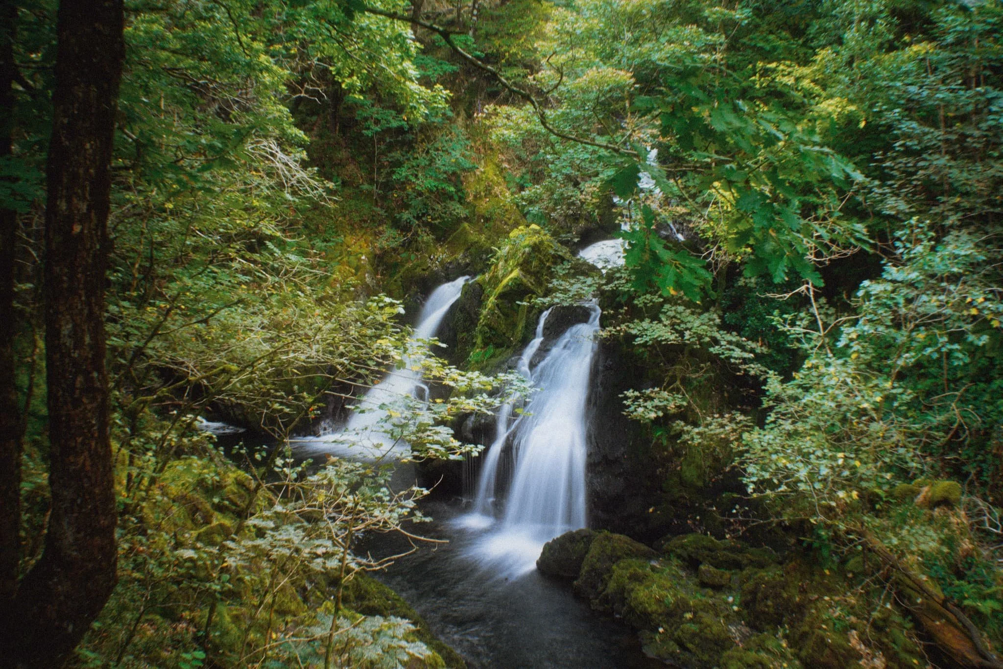
Down at the valley bottom we entered Tongue Intake Plantation and picked our way up through the woods to find our main goal for the day: Colwith Force, a double spout waterfall. Evidence of the approach of autumn is all around us.
Some people simply turn around and head back, but we’re fans of following the trail as it ascends up and above the waterfall. From above it, interesting compositions can be found of all the falls before the main double spout.
Though a little dry this time, there’s a lovely series of falls above Colwith Force that deserve attention.
Beyond the upper falls we followed the circular trail back out of the plantation and sought the Little Langdale road back towards Skelwith Bridge. Emerging from the woods, the fells were now clear of the morning mist, revealing their autumnal coats.
Just goes to show the massive difference a change of light conditions can do to the mood and feel of a photograph. Loughrigg and the Grasmere fells beyond, now clearly visible.
Herdwick yows (ewes) and their lambs peacefully graze in the now gorgeous autumnal morning sun. A timeless scene.
Nearing Skelwith Bridge, we could finally see the Langdale Pikes after being consumed by the fog all morning.
Did you enjoy these photos?
Aber Falls, Snowdonia, Spring
Much like South Wales, North Wales and Snowdonia has its fair share of waterfalls.
Much like South Wales, North Wales and Snowdonia has its fair share of waterfalls.
One such waterfall we’ve never visited before, and was relatively close to where we’re staying for the week, is Aber Falls, just south of the village of Abergwyngregyn.
For most people, this involves a very simple walk from the Nature Reserve car park to the falls. But there is a second waterfall, less visited, that we decided to check out too.
The late afternoon/early evening gave us glorious light to work with, and the scale of the waterfalls were a sight to behold.
Photos taken on my Sony a7ii using a Vivitar “Series 1” 28–105mm f2.8–3.8 zoom and Rokinon 14mm f2.8 prime lenses. RAWs developed in Capture One for iPad, then edited and finalised in Affinity Photo 2 for iPad.
The falls are very popular. Accompanying us on the walk to Aber Falls were a large group of overseas students enjoying the delights of Wales. The falls can be seen from miles away.
We made it to Aber Falls in no time and began scrambling around the boulders, seeking compositions of this 120ft waterfall plunging into its pool.
Of course, we weren’t the only ones at the falls, so patience was required to shoot photos when people left the frame. Additionally, I shot many exposures to really push the limits of how slow I could get the shutter speed whilst handheld. The Sony a7ii served me well.
Further along the head of the valley one can find another, less-visited, waterfall. This is Rhaeadr-bach or Rhaeadr Fach, which essentially means “smaller waterfall”, with Aber Falls technically named Rhaeadr-fawr, or “bigger waterfall”. This smaller waterfall had hollowed out a perfect little raised pool before dropping further into the river.
Did you enjoy these photos?

New Lanark & the Falls of Clyde, Scotland, Winter
We’re back in the Highlands for a week!
We’re back in the Highlands for a week!
On the way up from Cumbria, we stopped off roughly halfway through to check out a place we’ve been meaning to visit for ages: New Lanark and the Falls of Clyde.
New Lanark village—now a World Heritage Site—is a “planned settlement“, founded in the late 18th century Scottish industrialist David Dale alongside English entrepreneur Richard Arkwright. Cotton mills were built here to take advantage of the only waterfalls along the River Clyde, and housing was also built for all the mill workers.
Further up the Clyde, one can find several large waterfalls especially the pinnancle Corra Linn, which drops 84ft and is the 9th largest waterfall in the UK.
Although there was disappointingly little water in the Clyde, after a relatively dry winter, the walk itself was beautiful, the scenery gorgeous, and the village fascinating.
All photos taken on my Fujifilm X-T2 using my Vivitar “Series 1” 28–105mm f2.8–3.8 zoom lens. RAWs developed in Capture One for iPad using Digistock’s Ektar 100 film profile, then finalised in Affinity Photo 2 for iPad.
New Lanark & the Falls of Clyde, Scotland, Winter by Ian Cylkowski is licensed under CC BY-NC-SA 4.0![]()
![]()
![]()
![]()
There is no public parking allowed in New Lanark, so you have to park in the designated car park above the village then follow the footpath down. Here I framed the bell tower above the New Buildings.
One of many things that makes New Lanark unusual is that there are no street names. Instead, the buildings are named, and often very directly so. The nearby block of four houses are called Wee Row, and the larger block of 8 are Double Row.
We exited the footpath into the village proper, following the signs towards the Falls of Clyde. The buildings on the left are named New Buildings, millworker housing, named so because they are the newest to be built.

A closer look at Wee Row and Double Row in the distance. The longest block of housing on the right is called, you guessed it, Long Row. Nearby, to the left, is David Dale’s House, one of the founders of the village.
Walking down the street alongside New Buildings, with the bell tower front and centre in the block. It used to ring every day to single the start of work, but now only rings once a year on New Year’s Day.
We followed the signage towards the Falls of Clyde, but looked back to capture this great summary view of the village.
The first falls you come across are a series of powerful cascades known as Dundaff Linn. They’ve created a series of cataracts in the river bed, tessellating together like Tetris.
Further up from Dundaff Linn, a weir has been constructed allowing for this slightly unusual composition that I enjoy.
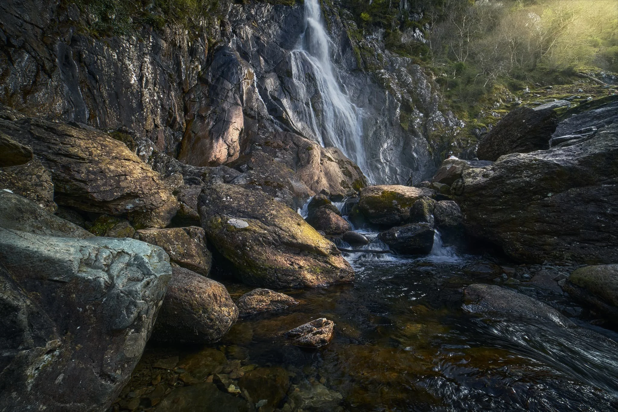
The first glimpse of the main waterfall of the Falls of Clyde: Corra Linn, dropping 84ft. Looking a little dry unfortunately after a relatively dry winter. It’ll be good to revisit after rain.
Further up the gorge is the third of the Falls, known as Bonnington Linn. These falls also mark the point where you return back to New Lanark.
We returned back to New Lanark close to the river. Alongside the river are the main Mill buildings. Mill 3 still has its roof in tact, but Mill 2 now has a roof garden and cracking views.
The waters of Mill Lade trickle alongside Mill 2, leading towards Mill 1, which is now the New Lanark Mill Hotel.
Did you enjoy these photos?

The Elidir Trail Falls, Powys, South Wales, Autumn
Our last full day in South Wales.
Our last full day in South Wales.
We’d previously enjoyed some waterfall action at Cwm Rhaeadr near Llandovery. But that was just one waterfall, even though it was a mighty one.
Deep in the heart of the Brecon Beacons National Park one can find Waterfall Country, home to a myriad of waterfalls. Easily the most popular trail around here is the Four Falls Walk, which we’ve done before way back in 2018. However, word is that this particular trail has become even busier.
Instead, for our last full day, we elected to walk the Elidir Trail. Somewhat less busy but the waterfalls are no less impressive.
We were not disappointed, and beautiful light for woodland and gorge walking aided us for our final day.
All photos shot on my Fujifilm X-T2 using my Vivitar “Series 1” 28–105mm f2.8–3.8 zoom and Laowa 9mm f2.8 prime lenses. RAWs converted in Capture One for iPad, then developed and finalised in Affinity Photo for iPad.
The Elidir Trail Falls, Powys, South Wales, Autumn by Ian Cylkowski is licensed under CC BY-NC-SA 4.0![]()
![]()
![]()
![]()
The Elidir Trail gorge heads upstream where it forks into two distinct sections. The shorter branch is a simple diversion to the viewing point for the main waterfall of the area, called Sgwd Gwladys. After a day or two of rain, the gorge was wet and the atmosphere was moist. Thankfully, that resulted in beautiful soft reflected light in this autumnal scene.
An ultra-wide composition of Sgwd Gwladys, and possible one of the greatest waterfall photos I’ve ever managed to shoot. A dead tree provided nutrition for a whole collection of fungi, serving as my foreground interest with Sgwd Gwladys gracefully rushing over a shelf in the distance.
We gingerly navigated the slippery and mossy boulders to get as close to the falls as possible whilst the light shining down into the gorge was still complementary. Rusty autumn leaves provide colour contrast in the foreground.
Further up the main gorge created by the River Neath (or Afon Nedd), a group of early-20s lads examined a potential swimming and diving spot.
Autumn in a micro scene, as the afternoon sun pierced the clouds above for a particularly strong burst of light.
Here the gorge and river widens up, allowing more autumnal light to pour into the scene on these two cataracts.
Towards the top of the Elidir Trail an almost impossibly perfect autumnal waterfall scene emerges as we clamber down the gorge to gawp at Scŵd Ddwli.
The name of these falls, Scŵd Ddwli, translates roughly to “gushing falls”, which we found to be wholly accurate. Around the edge of the plunge pool, rusty autumnal leaves had gathered making for a lovely composition.
Though we neared the end of the Elidir Trail, and the clouds had gradually covered the gorge, we got a final explosion of light from the late afternoon sun, shooting beams across the falls.