
Feizor, Yorkshire Dales, Spring
I don’t explore the Yorkshire Dales enough.
I don’t explore the Yorkshire Dales enough.
After finally getting over my post-Skye mourning and depression period, it seemed like spring finally arrived in Northern England.
Aware of how busy the Lake District would be, we instead ventured east to the Yorkshire Dales. We quickly realised that we hadn’t explored the Feizor area of the Dales in a long time, like maybe 7-years or so. Time to fix that.
Feizor (pronounced “FAY-zer”) is a tiny l’al hamlet between Austwick and Settle, and easy to miss. Home to a few houses, a farm, and the famous Elaine’s Tearoom, rising high above the hamlet are the limestone fells of Pott Scar and Smearsett Scar. These were the focus of the day’s hike and exploration.
Pott Scar and Smearsett Scar were beautiful examples of limestone karst landscapes, but they also offered immense views to either the back of Ingleborough or the shapely Pen-y-ghent.
A super day.
All photos taken on my Sony α7ii using my Sony FE 28–70mm f3.5–5.6 OSS and Vivitar “Series 1” 70–210mm f2.8–4.0 zoom lenses. RAWs developed in Lightroom, then tweaked and finalised in Photoshop.
Feizor, Yorkshire Dales, Spring by Ian Cylkowski is licensed under CC BY-NC-SA 4.0![]()
![]()
![]()
![]()
A near-timeless scene in the heart of Feizor. Old stone buildings, dry stone walls, foliage everywhere, and the fells rising up behind.
This quaint scene, complete with old water pump, was something I couldn’t resist making a composition of.
Round the back of Pott Scar, before ascending, one can enjoy expansive views towards Pen-y-ghent, one of the Three Peaks of the Yorkshire Dales.
The squelchy slog up the fell was rewarded with beautiful views from Pott Scar towards Smearsett Scar.
Fin-like clints and grikes of limestone made for a nice leading line towards Smearsett Scar.
Nearer the edge of Pott Scar, I focus stacked these bare limestone edges as they curved off into the distance towards Smearsett Scar.
From the summit of Smearsett Scar, the full extent and shape of Pott Scar is revealed. The day was brightening up too, albeit with a haze.
The summit of Smearsett Scar offers a bounty of limestone clints and grikes that I want to make compositions of.
Another variation from the summit of Smearsett Scar, using the exposed clints and grikes as a leading line towards Pott Scar.
Back down the back of Pott Scar, drafting clouds cast dancing shadows across Moughton Scar and the back of mighty Ingleborough, another one of the Three Peaks of the Yorkshire Dales.
Plenty of teeny Swaledale lambs about, hastily retreating back to their mums as we followed the track back to Feizor.
The single road that winds its way through Feizor.
A super-zoomed in composition of the back of Ingleborough, taken from the small lane between Feizor and Buck Haw Brow, light dancing across the karst features of the land.
Did you enjoy these photos?

Hull Pot, Yorkshire Dales, Winter
A month since my last post.
A month since my last post.
I do apologise.
The weather in January has been, well, shocking to say the least. We endured three named storms: Henk, Isha, and Jocelyn. Isha, in particular, was one of the most powerful storms the British Isles have seen since 2000.
Additionally, we’ve had periods of below freezing temperatures, resulting in widespread ice.
It’s been… interesting.
Thankfully, the weekend just gone, it was nice enough for us to finally head out. We chose the Hull Pot route from Horton-in-Ribblesdale in the Yorkshire Dales. I had an inkling that there’d still be some snow liggin’ about in the Dales, contributing to a water-saturated landscape and, hopefully, a waterfall flowing into Hull Pot.
And we finally saw it.
All photos taken on my Sony α7ii using my Pentax SMC 28mm F3.5, Pentax SMC 55mm f2.0, and Rokinon 14mm f2.8 ED AS IF UMC prime lenses. RAWs developed in Lightroom, edited and finalised in Photoshop.
Hull Pot, Yorkshire Dales, Winter by Ian Cylkowski is licensed under CC BY-NC-SA 4.0![]()
![]()
![]()
![]()
The characteristic drystone walls of the Yorkshire Dales remained steadfast in the face of all the snow we’ve had recently, resulting in these snowdrifts piled up against them.
Our way forward. We knew on this day that there’d only be 2-3 hours of good light, and boy was it dramatic.
Looking back at where we came from. We were very much on the edge of two weather systems. Conditions over Horton-in-Ribblesdale saw blue skies and puffy clouds, but closer to Pen-y-Ghent it was blowy, dark, and stormy, giving us epic light.
A good sign: A small waterfall where there usually isn’t at Horton Scar. Above, Pen-y-Ghent fights with the dark and stormy clouds.
Further up the bridleway, the site of an extinct waterfall below Pen-y-Ghent, which is now obscured by clouds laden with snow. A burst of sun to our right picks out the details in the land.
And there she is, finally ticked off my bucket list. England’s largest natural hole, Hull Pot, with Hull Pot Beck tumbling down 60ft into the chasm. As mentioned before on this blog, Hull Pot is a large cave where the roof has collapsed, which has resulted in this massive chasm below Pen-y-Ghent. With my ultra-wide 14mm equipped, I was able to capture the entire scene.
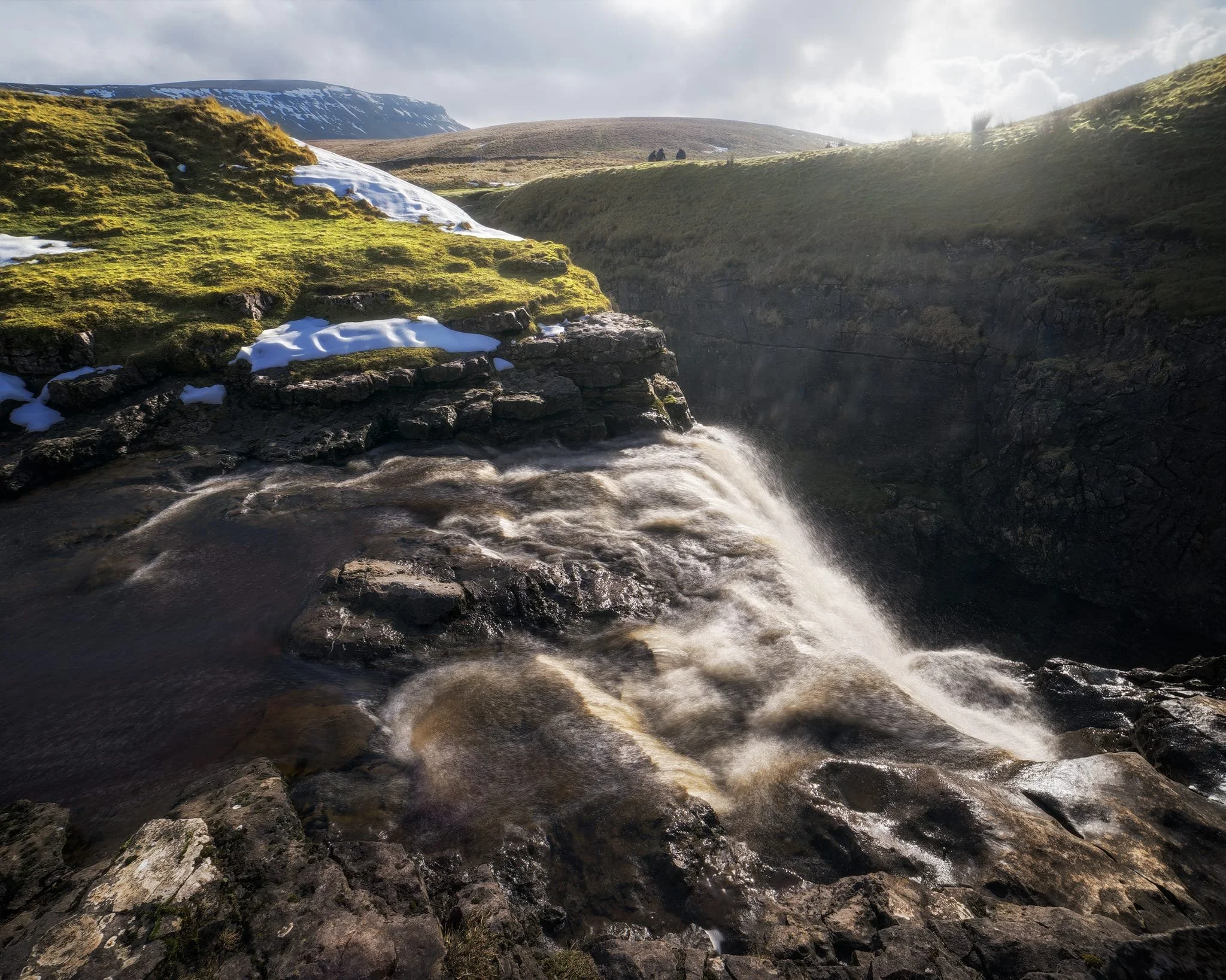
We clambered as close to the waterfall as possible as it crashed over the edge into Hull Pot. As I had no tripod, I shot this with my ultra-wide 14mm at f/22, taking multiple exposures of the same scene. In post, I then averaged the exposures together that gave me that long exposure effect on the water.
Looking up Hull Pot Beck and its many cascades. By the normal way of things, this beck is dry as it usually disappears into the maze of caves beneath Pen-y-Ghent before it reaches Hull Pot. With all the rain and snow we’ve had, the beck was able to complete its route, crashing 60ft down into Hull Pot and re-emerging at the surface nearer Horton-in-Ribblesdale.
A different view of Hull Pot from its eastern end. Two boulders balance precariously on the lip of the pot.
At around 450 m/1,476 ft above sea level, a few snow patches have lingered around the edges of Hull Pot, allowing for some interesting compositional leading lines.
A particularly clean snow patch nearer the falls gives me an idea for a composition involving Pen-y-Ghent in the distance. Fellow hikers milling about the edge of Hull Pot give you a sense of scale of this place.
Heading back down to the village, signs were clear that the best of the day’s light were done as the storm clouds rolled in. We were thankful to get what we did, though.
Did you enjoy these photos?
Grassington, Yorkshire Dales, Autumn
Autumn is coming.
Autumn is coming.
Knowing that yet more rain was on its way in the afternoon, and that our best chances were further east, we elected to head into the Yorkshire Dales. Here we embarked on a nice 10 km hike, taking in the epic Linton Falls, timeless Grassington, and Grass Wood Nature Reserve.
While there were certainly hints of autumn colours, it seems we need another couple of weeks around our latitude before they reach peak conditions. That’s assuming, of course, that the weather cooperates and doesn’t just blow all the leaves straight off the trees.
Although strictly speaking a town, Grassington has a wonderfully timeless Yorkshire village vibe. As a result, it was selected as the primary location for the 2020 reboot of All Creatures Great and Small, playing the role of the fictional Yorkshire town of Darrowby.
All photos shot on my Sony α7ii using my Sony FE 28–70mm f3.5–5.6 OSS zoom lens. RAWs were largely developed using Capture One for iPad, and finalised using Lightroom for iPad and Darkroom for iPad.
Grassington, Yorkshire Dales, Autumn by Ian Cylkowski is licensed under CC BY-NC-SA 4.0![]()
![]()
![]()
![]()
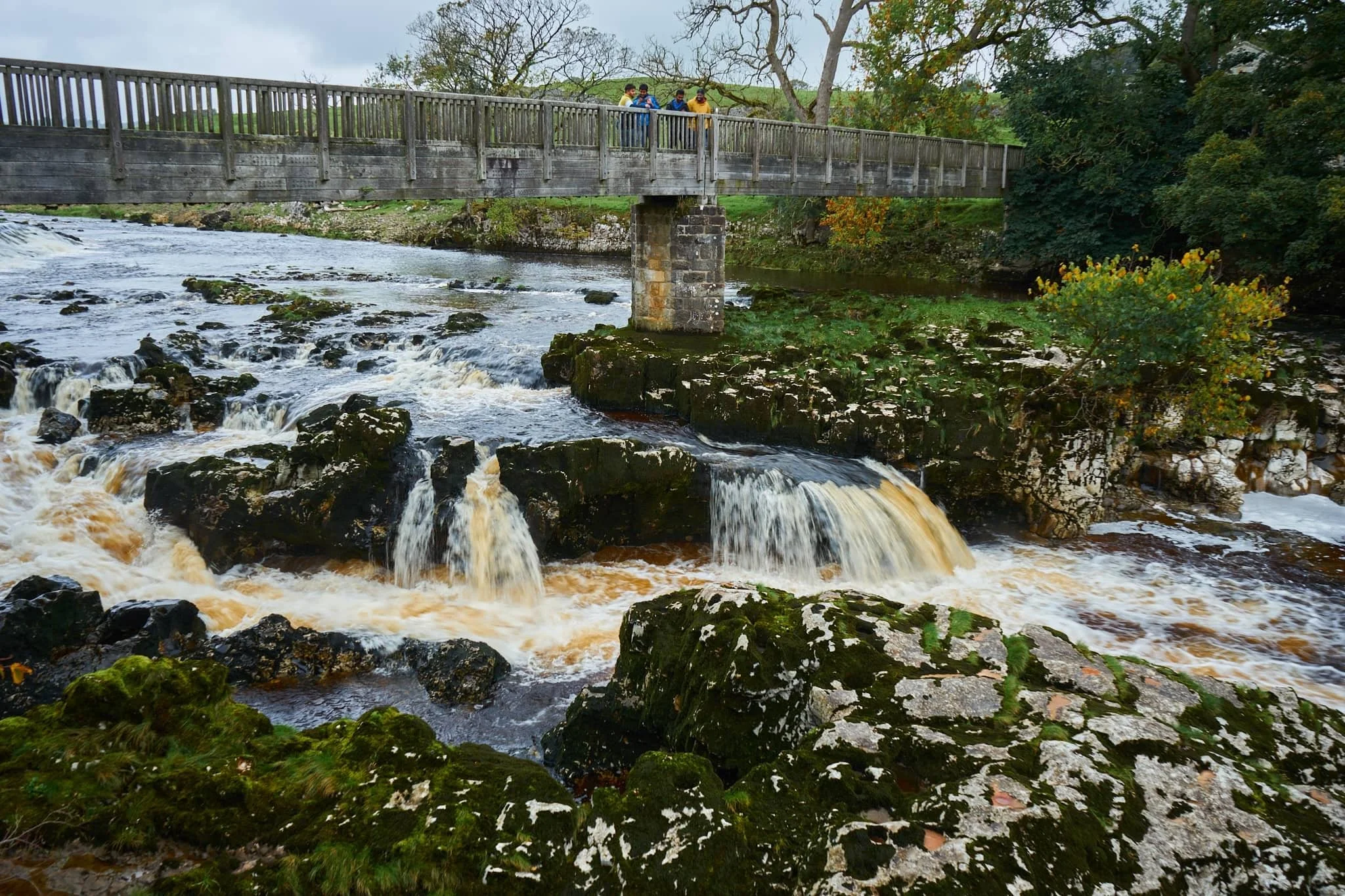
Linton Falls, a series of powerful cascades crashing over a limestone fault in the River Wharfe.
Just above the falls are a couple of weirs that sweep across the river, disrupting the flow of water so as not to sweep away at the river bank so much.

My Lisabet on the footbridge above the thundering falls. It’s quite the drop and a somewhat unnerving sensation.
From the footbridge looking down, it’s easy to make out the fault. Here, a prehistoric seismic shift in the earth will have uplifted some of the limestone in the river bed higher than the rest, creating these cascades and limestone platforms.
Looking upstream, you can make out the second weir and Linton Falls Hydro. There’s been a hydroelectric power station here since 1909, but was closed down in 1948. Decades later, in 2012, the building came back into use once again as a hydroelectric generating power station, modified to minimise harm on nature and local wildlife.
Beyond the footbridge we took the ancient Sedber Lane up the fellside towards Grassington. Looking back down offers an enchanting, if moody, Yorkshire Dales scene.
Grassington. Mentioned in the Domesday Book of 1086 CE, the village was originally documented as Gherinstone, Garsington, or Gersington. The name is a mix of Old Norse and Old English, meaning either “the town of the grassy ings” or a “farmstead surrounded by grass.”
Stopping for some coffee and cake, we then wandered gently around the village documenting some of the more timeless scenes Grassington had to offer (save, of course, for all the vehicles unceremoniously dumped everywhere).
A lot of old architecture in Grassington has survived remarkably well, aiding the village’s “ye olde worlde” appeal.
Bunting zigzagged across the skyline above us as we made our way up the higher parts of Grassington.
The Black Horse Hotel. Originally built in the 17th century as a coaching inn, it saw additions and alterations in the 18th and 19th centuries.
Above the Black Horse Hotel, we continued up Garrs Lane. Save for the road markings, you could easily transport your mind back several centuries, looking at this scene.
A beautiful cottage with window shutters. To the right an old resident had just finished tending to a beautiful garden.
Right near the junction of Main Street, Garrs Lane, and Moor Lane, this wonderful shop—Ashton House Crafts & Carving—was busy displaying all its various sculptures, carvings, and wood chimes. Just delightful.
Chamber End Fold has maintained its cobbled street, helping to cement this ageless Yorkshire scene (if we carefully ignore the car).
We continued up north out of Grassington, taking the ancient Bank Lane onto the Dales High Way and west towards Grass Wood Nature Reserve. Old stone barns decorate the way towards the woods.
These little pops of autumn hues were a tantalising prospect of what is to come.
Grass Wood Nature Reserve is one of the largest broadleaved woodlands in the Dales, comprised primarily of ash woodland interspersed with limestone scars. We followed the minor trail alongside Gregory Scar, thick in the woods.
A delicate little scene, showing the beginnings of those beautiful autumnal colours.
Nearing the exit, this part of the woods was carpeted in fallen autumnal foliage.
Nearing Grassington via Grass Wood Lane, one final composition arrested my attention near the cricket grounds.
Did you enjoy these photos?

Kingsdale, Yorkshire Dales, Autumn
Flexibility can lead to great things.
Flexibility can lead to great things.
We started a promising Saturday morning with a plan to hike up the highest peak in the Yorkshire Dales: Whernside (736 m/2,415 ft).
It would definitely be the highest peak we’ve ever ascended but we were planning to “cheat” a little bit. Below Whernside’s western flank is a valley called Kingsdale. There’s a road that runs from the south, near Ingleton, through and over Kingsdale before dropping back down into Dentdale. This road enjoys a few large passing places, one of which is near the summit of the road at 468 m a.s.l. In theory, we could park at the passing place and hike the minor trail up Whernside’s western flank to reach the summit, with only 300 m of actual ascent needed.
We didn’t go for it in the end. Parking in passing places is generally a no-no, and the trail and landscape around Whernside’s western flank looked rather boggy.
Instead, we drove back down to the valley bottom of Kingsdale and stopped at an actual parking place. Here we elected for a hike up Kingsdale’s magnificent limestone fellside to locate the magnificent Cheese Press Stones.
It turned out to be a great idea on a beautiful day.
All photos shot on my Sony α7ii using my Sony FE 28–70mm f3.5–5.6 OSS zoom lens. RAWs developed in Lightroom using RNI Films’ Kodachrome film profiles, finalised in Photoshop.
Kingsdale, Yorkshire Dales, Autumn by Ian Cylkowski is licensed under CC BY-NC-SA 4.0![]()
![]()
![]()
![]()
Straight away from our little parking bay, the views across to Twistleton Scar and Ingleborough were magnificent. They were only going to get better.
The road north through Kingsdale, with the valley’s fantastic scar looming directly above. The main scar above the road is known as Keld Head Scar. The start of the hike heads up the fellside just as the road veers right.
Part way up Keld Head Scar, and a single tree growing out of a limestone boulder provides a nice subject with Whernside in the distance.
As we clamber through the irregular clints and grikes of limestone, and navigate the occasional boulder, Ingleborough emerges from above Twistleton Scar. An old drystone sheep pen provides a nice foreground subject contrast against the fell in the distance.
A large cluster of limestone boulders, no doubt dumped in position by the last Ice Age, provide a nice foreground focal point. They also, happily, seem to “point” towards Ingleborough.
Finally, after a fairly challenging hike and scramble through Keld Head Scar, we emerged onto a limestone plateau where we easily spotted the Cheese Press Stones. These are a pair of giant limestone boulders, probably deposited here after the last Ice Age. Why are they called the “Cheese Press Stones”? No idea.
The boulder on the left is a good 9–10 ft tall. Some estimate its weight at around 15 tons. Here, an obvious composition is hard to ignore, using the two boulders to centre and frame Ingleborough.
A few yards away, I spot another interesting limestone boulder, which appears to me almost like a cracked open egg.
Further up the plateau, a group of large limestone boulders attract my attention. I line a composition, attempting to fill the frame with them whilst keeping Whernside visible in the distance.
I circle around the cluster of boulders to find a composition featured Ingleborough. It means shooting directly into the sun, but thankfully Sony RAW files are incredible flexible.
I locate Lisabet near North End Scar, perched atop a small crag, happily editing her photos. In the distance, the Forest of Bowland is just about visible.
The way back involves navigating this ankle-breaking limestone pavement to relocate the minor trail, which takes you below North End Scar, past Tow Scar, and back down to the road.
Beneath North End Scar’s western edge, the layering and striations of the limestone is fascinating.
I am a sucker for a good drystone wall composition.
The criss-crossing and weaving of the valley and its various limestone scars and layers provide me a delightful photo with Whernside high in the distance.
Nearly back at the car, with the limestone scar of Kingsdale’s western edge in full display. A beautifully sculpted glacial valley.
Did you enjoy these photos?

Dent, Yorkshire Dales, Autumn
Time to revisit an old friend.
Time to revisit an old friend.
With fairer conditions promised, we head out as soon as I finished work on Friday evening. We’d managed to book a table at the Meadowside Cafe in Dent, but beforehand we wanted to get reacquainted with this magical valley.
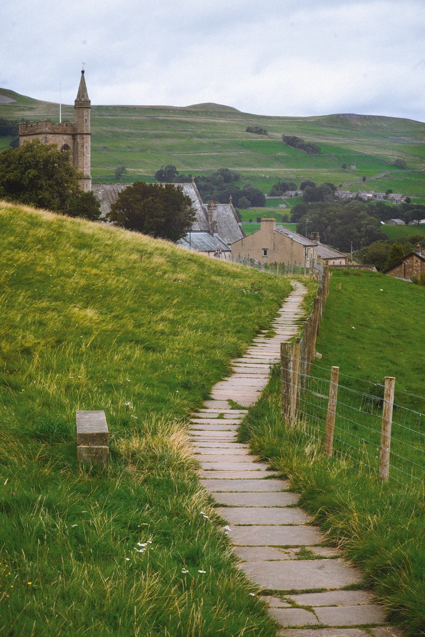
Dent is small, old village situated in a valley of its namesake: Dentdale. The valley is narrow and steep-sided, with Aye Gill Pike (556 m/1,824 ft) looming above Dent on the northern side and Great Coum (687 m/2,254 ft) rearing up behind.
The village itself is gorgeous, featuring buildings that are three to four centuries old, a cobbled village centre, gorgeous old church, and more.
We relished a light-hearted trek towards the south along the slopes of the fell, aiming to explore the Dancing Flags at Flinter Gill. The Dancing Flags are a vast spread of flat, naturally occurring stone slabs, which for centuries were employed by local weavers to 'waulk' their freshly woven cloths, traditionally referred to as 'webs'. 'Waulking' involved the process of thoroughly soaking the cloth before stepping on it barefoot, leading to a minor shrinkage and 'felting up' of the fabric. This resulted in a much denser and consequently warmer material. This technique was once universally adopted and was often referred to as 'dancing the web' in various regions, thus giving the stones their name.
After wandering around the village, it was time to pack the gear away and enjoy a fabulous meal at Meadowside Cafe.
All photos taken on my Sony α7ii using my Sony FE 28–70mm f3.5–5.6 OSS zoom lens. RAWs were developed in Lightroom for iPad using RNI Films’ Kodachrome film profiles, then finalised in Affinity Photo 2 for iPad.
Dent, Yorkshire Dales, Autumn by Ian Cylkowski is licensed under CC BY-NC-SA 4.0![]()
![]()
![]()
![]()
From the main village car park, there were already tremendous views over the old sandstone houses to Middleton Fell and the wall of Combe Scar.
This is where Flinter Gill tumbles down the Dancing Flags. At least, where it normally does. Despite all the rain we saw in July and August, Flinter Gill was exceptionally dry.
From near the Dancing Flags, the views back down to Dent village were exceptional.
It will be nice to shoot the Dancing Flags when there’s loads of water pouring down. Of course, that will also make it harder to get close.
Heading back down into the village, we enjoyed the almost timeless scenes that Dent presents around nearly every corner.
Save for the car and satellite dish, this scene could be from 1923, rather than 2023.
Not a bad backdrop for a football game, eh?
Some of these houses in Dent date back to the 1600s. One such building was the birthplace and home of Adam Sedgwick, the “father” of British geology.
A rusty barn provides a beautiful colour contrast to all the surrounding greenery. Above, a beam of light scans across the fellside of Aye Gill Pike.
Crossing the 18th century Church Bridge with staggering views towards Aye Gill Pike.
Back over towards the northwestern side of the village, the road serves as a leading line towards Helms Knott as the light starts to fade.
The signage may have changed over time, but this scene will have been relatively unchanged for a century or so.
Stone Close is a 17th century tea room, it’s walls thick and whitewashed. The cobbled road points deeper into the village.
St. Andrew’s Church, with Aye Gill Pike behind it. The church dates from the 12th century, with the tower added in the 18th century. It was restored in the late 1800s.
The George & Dragon hotel and pub, rebuilt in the 19th century. To the right, a home maintains its original Martins Bank Ltd. signage. This was bank company was formed around 400 years ago, and had a significant presence throughout the north of England. It was bought by Barclays in 1969.
Did you enjoy these photos?

Hawes, Yorkshire Dales, Summer
A Bank Holiday Monday meant a day out with me Dad.
A Bank Holiday Monday meant a day out with me Dad.
After heading down to Kendal to meet me we decided to let his new car “stretch its legs”, so head east into the Yorkshire Dales. A wander around Hawes and the beautiful Upper Wensleydale was in order.
It’s been a while since I’ve wandered around Hawes, and I was stunned by how busy and seemingly thriving it was. Hawes has always been popular with bikers anyway, but beyond the regulars there were scores of people enjoying the sights of what Hawes has to offer.
We timed it well, too. Not long after leaving Hawes via Blea Moor Road and the Ribblehead Viaduct, the heavens opened and the rain fell.
All photos taken on my Sony α7ii using my Sony FE 28–70mm f3.5–5.6 OSS and Vivitar “Series 1” 70–210mm f2.8–4.0 zoom lenses. RAWs were developed in Lightroom for iPad using RNI Films’ Kodachrome film profiles.
Hawes, Yorkshire Dales, Summer by Ian Cylkowski is licensed under CC BY-NC-SA 4.0![]()
![]()
![]()
![]()
Hawes was so busy that we couldn’t find any parking within the town. We had to stop outside the eastern end of the town. Thankfully, that afforded us views down Wensleydale like this.
A proper bucolic northern English scene, with the characteristic golden sandstone buildings of Hawes with the crags of High Clint in the distance.
One of Hawes’ most well-known scenes. Gayle Beck flows north from Sleddale and through Hawes town centre, dropping here as a beautiful series of falls.
One of many independent shops in Hawes, some have been here longer than others.
Hawes has an almost timeless aspect to it, save for the bright blue bins of course. No matter where you look, you can always see the fells of Upper Wensleydale.
There were plenty of crochet sheep and yarn bombing all around Hawes, raising funds for Great Yorkshire Ambulance.
Look at these fantastic woollen renditions of Wallace and Gromit! Wallace & Gromit is a stop-motion animation franchise, and Wallace became well-known for his love of Wensleydale Cheese. It can be argued that the renewed interest in this cheese, courtesy of Wallace & Gromit, was what saved the Wensleydale Creamery from bankruptcy.
I couldn’t resist immortalising this timeless scene. I wonder how long they’ve been going for?
We wandered up the road towards Gayle to take in a loop of the town and get some higher vantage views of it. Here, the road points the way towards Wether Fell (614 m/2,014 ft).
The cap of Yorburgh with a pair of trees point towards it.
The well-maintained path takes you around the back of Hawes and opens up the views from above it. Here, the path serves as a leading line past St. Margaret’s Church and over the buildings of Hawes, with the nub of Smuker Hill, part of Lovely Seat, visible.
I love capturing timeless rural scenes like this. Hawes makes it very easy.
Taking the little back yards of Hawes makes you feel like you’ve stepped back in time.