Pandemic Peregrinations: Whitbarrow, Cumbria, Spring
I’ve often gazed longingly at Whitbarrow Scar from afar.
I’ve often gazed longingly at Whitbarrow Scar from afar.
Finally we decided to clamber around it.
Whitbarrow (215m/705ft) is a limestone hill, much like its neighbour Scout Scar, with whom I’m much more familiar with. Whitbarrow is further west of Scout Scar across the Lyth Valley, but covers a much larger area. When viewed from the A590 south of the fell, Whitbarrow presents some sheer and imposing cliff faces that I instantly fell in love the first time I saw them. I resolved to one day wander around the contours of Whitbarrow. Today was that day.
Whitbarrow is definitely not as easy to access as Scout Scar. Whereas Scout Scar can be reached with ease from the tiny car park near its northern edge (or walked to directly from Kendal), Whitbarrow has no official car park nearby and is surrounded only by tiny villages and hamlets. We elected to park in one of the laybys off the A5074, then walk into the village of The Row to find the footpaths up onto Whitbarrow.
We spent a good 2-3 hours around Whitbarrow and quickly got the distinct impression that this was a fell that we could return to time and time again, and still not see all of that. The fell is quite vast and varied. Its western flank drops down steeply to the valley floor at Whitbarrow Scar, but does so more smoothly compared to Scout Scar’s vertical cliffs. The eastern part of Whitbarrow is a protected Nature Reserve, featuring limestone shelves, limestone pavements full of clints and grikes, and lots of woodland.
We managed to summit the fell at Lord’s Seat and made a small loop back towards The Row. There is still a lot to more explore of Whitbarrow, and I look forward to returning again.
All photos shot on my Fujifilm X-T2 using my three prime lenses: a Samyang 35mm f/1.2, a Laowa 9mm f/2.8, and a converted Pentax SMC 55mm f/2.0. Developed using RNI’s Kodachrome film profiles.
As we started to ascend out of The Row, the views across the Lyth Valley towards the Far Eastern Lake District fells quickly opened up. We were blessed with another lovely day of weather.
There is considerably more woodland on and around Whitbarrow compared to Scout Scar.
From the woodland near The Row known as the Township Plantation, we branched off west towards the cliffs of Whitbarrow Scar. We wanted to see what the views towards the Lake District fells were like.
The way forward, with some runners up ahead. The sky was a lot more dramatic today, but still thankfully dry.
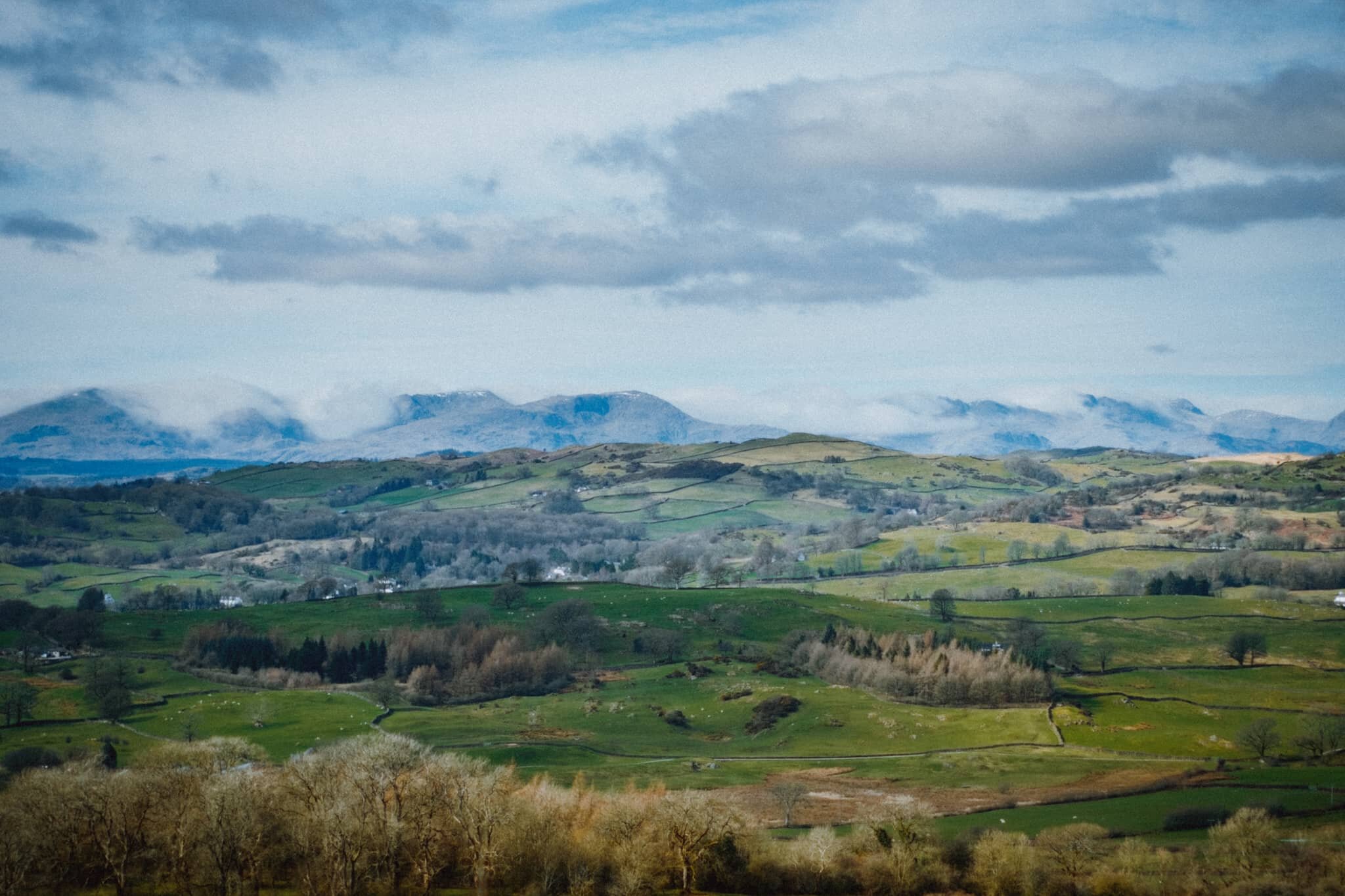
Now that’s a view. The Langdale Pikes towards the right, Wetherlam and the Coniston fells towards the left. Dappled light everywhere. Glorious scenes.
The cliffs north of Whitbarrow Scar with the Eastern Lake District fells in the distance.
Just amazing views of the Kentmere and Longsleddale fells.
Near Bell Rake the land drops away sharply, exposing these silver birch to the consistent westerly winds.
One of many glacial erratics around Whitbarrow, physical testament to the fell’s ice age history.
After summiting at Lord’s Seat we followed the “spine” south from the summit, taking in the views towards Morecambe Bay along the way.
Getting closer to the precipitous drop of Whitbarrow Scar.
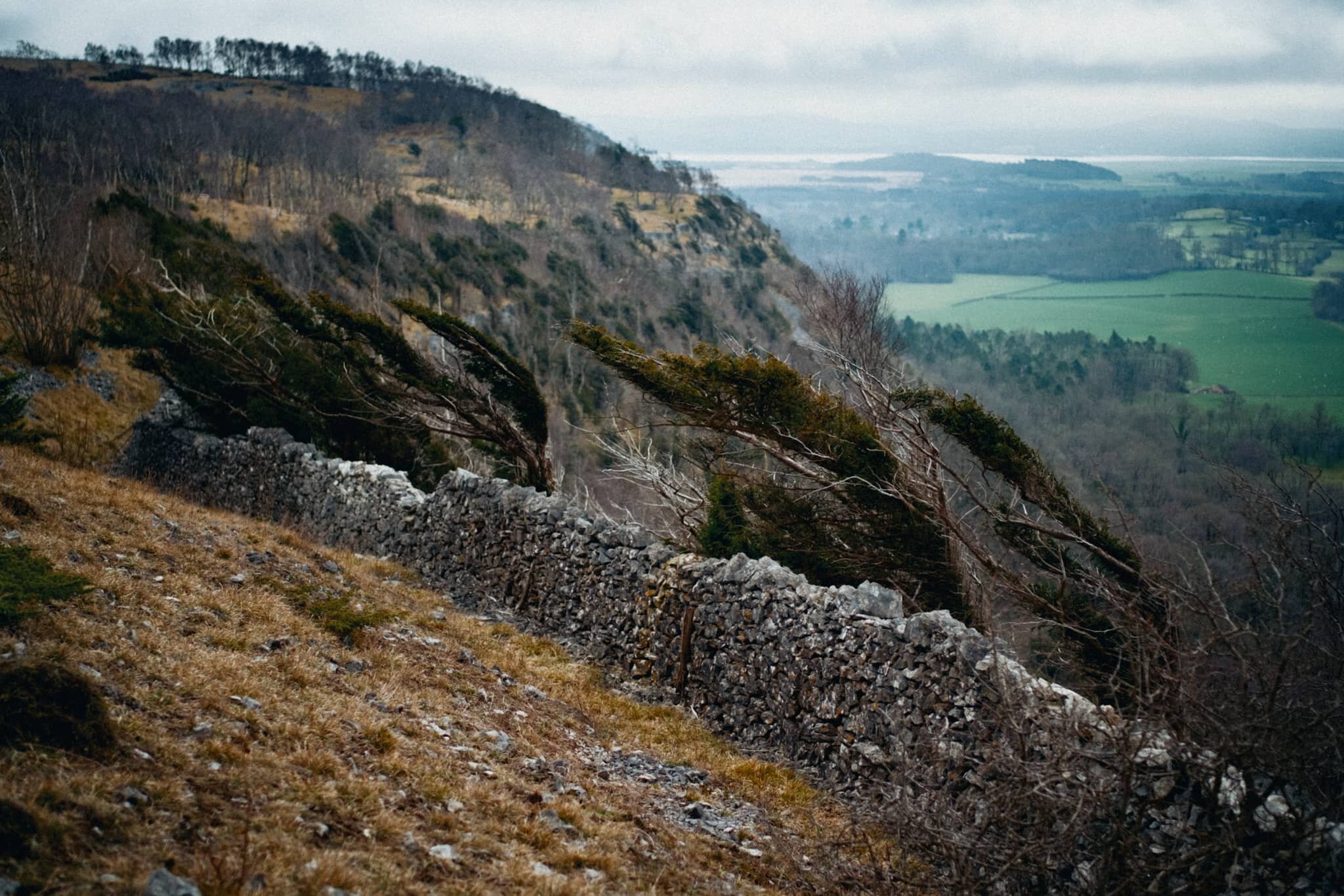
A wall prevents you from getting near the edge, lest you tumble towards the valley floor. Wind-blasted trees give an indication of what the conditions can be like on the fell.
More wind-blasted silver birch with moody skies.
Just one example of the almost impossibly perfect wall-like structure of the limestone pavements found near the Whitbarrow Nature Reserve.
Whitbarrow Nature Reserve is a limestone woodland, featuring all manner of flora that survives in the acidic soil conditions and changeable weather.
My ultra-wide 9mm lens had some fun following various tree trunks and branches for more unusual compositions.
We found this weird tree that appeared to have a separate tentacle-like trunk growing out of it. I got close and low with my 9mm lens to follow the line of this trunk.
A rather unusual tree, to my experience; the trunk is almost tendon-like in its structure. Google thinks this is Hesperocyparis macrocarpa, a Monterey cypress tree.
The way back to The Row through the Township Plantation. We’ll be back, Whitbarrow…
Pandemic Peregrinations: Kendal Fell, Cumbria, Spring
Spring has sprung.
Spring has sprung.
After a relatively dry and bright week, we were very much hoping for similar if not better for the weekend. Saturday came around and we were grateful. A proper spring day.
We took the opportunity to get some shopping in by hiking from the front door to Plumgarths Farm Shop via Helsfell Nab. Then, after acquiring the necessary meat, bread, and tasty beverage, we hiked up Cunswick Scar and back towards Kendal Fell into the town.
All in all, another solid 16,000+ steps or so.
There were so many birds singing, dappled light scanned across the land, the grass is getting green, people were out and about with smiles on their faces… a change is coming.
All photos shot on my Fujifilm X-T2 using my three lenses: a Samyang 35mm f/1.2, a Laowa 9mm f/2.8, and a Pentax SMC 55mm f/2.0. Developed using RNI’s Kodachrome film profiles.
I can rarely resist taking a photo of this house whenever I walk by. I believe the date stone on it says 1669 AD, making it around 350-years old. Crazy.
Hiking up towards Helsfell Nab, you pass some of these allotments that enjoy tremendous views towards the Far Eastern Fells. Plenty of people on their plots busy working away.
Another favourite composition of mine I can rarely resist. Give me dry stone walls, an open gate, and an all-encompassing view.
Just before we reached the track directly underneath Helsfell Nab, I stopped for this quick shot as I noticed the sun scanning light across the rolling fields above Kendal.
Large disused barns that mark the point where the footpath turns sharply and ascends up and around Helsfell Nab. What a dream it would be to own and convert these into housing. Imagine the views.
Over the bridge that crosses the A591, another photo that I just have to stop and shoot.
To get to Plumgarths you have to come off the footpath towards Cunswick Scar and make your way through Helsfell Farm.
These beauties will be let out onto the fields any day now.
Our primary destination: Plumgarth’s Farm Shop.
Lisabet nipped inside whilst I waited. We’re fortunate to be able to afford, and have access to, local produce here in Cumbria.
We also nabbed ourselves a couple of flat whites and nipped across the road into the gardens of the Cumbria Wildlife Trust to enjoy. The entrance to the Trust features these magnificent trees.
After shopping and hot beverage refreshments, we took the footpath beyond Plumgarth’s up Cunswick Scar via this steep wooded track. It’s usually quite muddy, and thus slippy, but thankfully a lot of the mud had dried out enough for ample traction.
Looking back the way we came. Can’t wait for this to start looking a lot greener. After reaching the top of Cunswick Scar, we were not prepared for what we saw across the Lyth Valley…
Check that out. Not only was the atmosphere clear enough to get a good glimpse of the Lake District fells, but the remnants of a temperature inversion had caused these “waterfalls” of clouds to spill over and around the fells. Absolutely incredible scenes.
And we weren’t the only ones enjoy this Spring Equinox epicness.
Cumbria being what it is, there’s always plenty of fell runners about.
Up on Kendal Fell we pause to look back and gawp once again at the incredible conditions playing out on the Lakeland fells.
Making our way back down Kendal Fell, with sprawling views across the town to enjoy.
You know what I’m like with winding drystone walls…
An absolutely beautiful day.
Benson Knott high above Kendal, getting more verdant by the day.
A lovely display of flowers high up one of the walls down Beast Banks. Google thinks this is Aubrieta deltoidea, sometimes known as lilacbush, purple rock cress, or rainbow rock cress.
Always gotta get a shot in of the Kendal Town Hall clock tower.
Pandemic Peregrinations: Serpentine Woods, Spring, Cumbria
Step 1 of the government’s Spring COVID-19 Response Plan is in action.
Step 1 of the government’s Spring COVID-19 Response Plan is in action.
Students have gone back to school and in theory by the 29th of March people will be allowed to meet outdoors in bigger groups.
The UK has also recently passed the vaccine milestone of 25 million people.
There is a… careful optimism in the air. The weather appears to be brightening and drying up, and the days are getting longer.
I know, personally, that I’m feeling a growing urge to be in the outdoors and for longer.
Thankfully, and fortunately, Lisabet and I have been able to plan some holidaying and exploring within the UK for 2021 (finger’s crossed). We’re looking at the Northumberland coast in the summer, and two areas of Scotland in the autumn.
Let’s hope all goes well with the vaccination programme and easing of restrictions.
In the meantime, here’s some photos of a recent post-work wander Lisabet and I enjoyed, taking in the sights, sounds, and smells of Serpentine Woods, above Kendal. Can’t wait until this place is filled with wild garlic blossom.
All photos taken on my Fujifilm X-T2 using a Samyang 35mm f/1.2 lens. Developed using RNI’s Kodachrome film profiles.
This bookshop hasn’t been in operation here since 2013, but this wonderful signage is still attached to the building.
Heading up Finkle Street with the setting sun creating a lovely warm glow on the horizon. The name of the street comes from the Old Norse vinkl, meaning “elbow”. Appropriate.
As we start to head up Beast Banks, I look back for a shot of Kendal Town Hall as it catches some golden light.
Part way up Beast Banks, I took another look back down for one of my favourite views in Kendal.
Kendal has proper lovely buildings.
On the entrance to Serpentine Woods we found this lovely patch of flowers in the shade and thought, “Bluebells? Already?!” Turns out, probably not. Google thinks they’re alpine squill, Scilla bifolia.
There was a time when I was overly concerned with achieving maximum exposure in my photos, attempting to capture as much highlight and shadow information as possible. Then later, a variety of complex editing and blending methods would be used to eke out as much dynamic range in an image as possible. These days, I’m much content to let a blown out highlight remain so, especially when shooting right into the sun. It’s the sun, of course it’s bright.
Serpentine Woods is filled with charming little scenes like this.
I love that soft light you get in the woods, especially when the last of the day’s light is dipping below the horizon.
One of my favourite little spots in Serpentine Woods: the Unnecessary Gate.
One of the aforementioned sculptures: a ladybird on the edge of a bench.
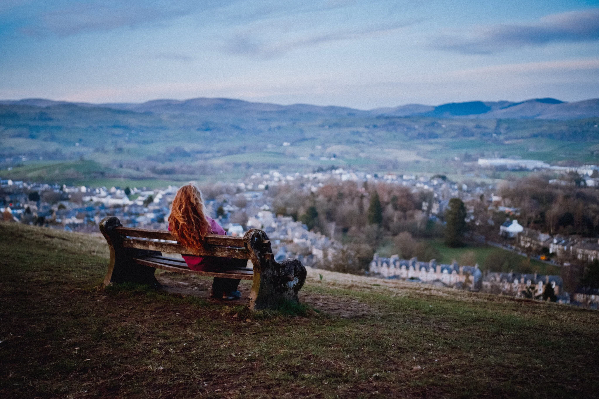
Once you pop out of the top of Serpentine Woods, an old bench invites you to rest and take in the view across Kendal towards the Eastern Lake District fells. Lisabet happily did so.
Vines weaving over a tree trunk like a novice knitter.
Not entirely sure what this sculpture is supposed to represent…
A lovely little sculpture of a rat perched on some limestone as we leave Serpentine Woods.
Back out the woods, we branch off Beast Banks towards Garth Row, passing by this view of Kendal near Castle Howe.
It’ll be a fine day when the Brewery Arts Centre is back open again.
Pandemic Peregrinations: Helsington, Cumbria, Spring
We’ve definitely had better light conditions recently.
We’ve definitely had better light conditions recently.
Nevertheless, Lisabet and I embarked on a solid 15 km hike today. From the front door, down the A6, through Helsington Laithes up to Scout Scar, south towards Helsington Church, through Berry Holme Farm, across the A591 to Hawes Bridge, and back north through the fields to Kendal.
It’s a good day when you get 20,000+ steps in and lots of photos.
All photos shot on a Fujifilm X-T2 using my three lenses: a Samyang 35mm f/1.2, a Laowa 9mm f/2.8, and an adapted Pentax SMC 55mm f/2.0. Developed using RNI’s Kodachrome film profiles.
Catkins belonging to the common hazel tree, or Corylus avellana. Always good to see these, a sign of spring.
Here’s a thing: did you know there’s such a job/profession as Lichenologist? Isn’t that wonderful? And such a crucial organism, too.
An appeasing group of common yew, Taxus baccata. Most parts of the tree is poisonous… just so you know.
Some structure we found when wandering south through Helsington Barrows. Potential apocalypse shelter?
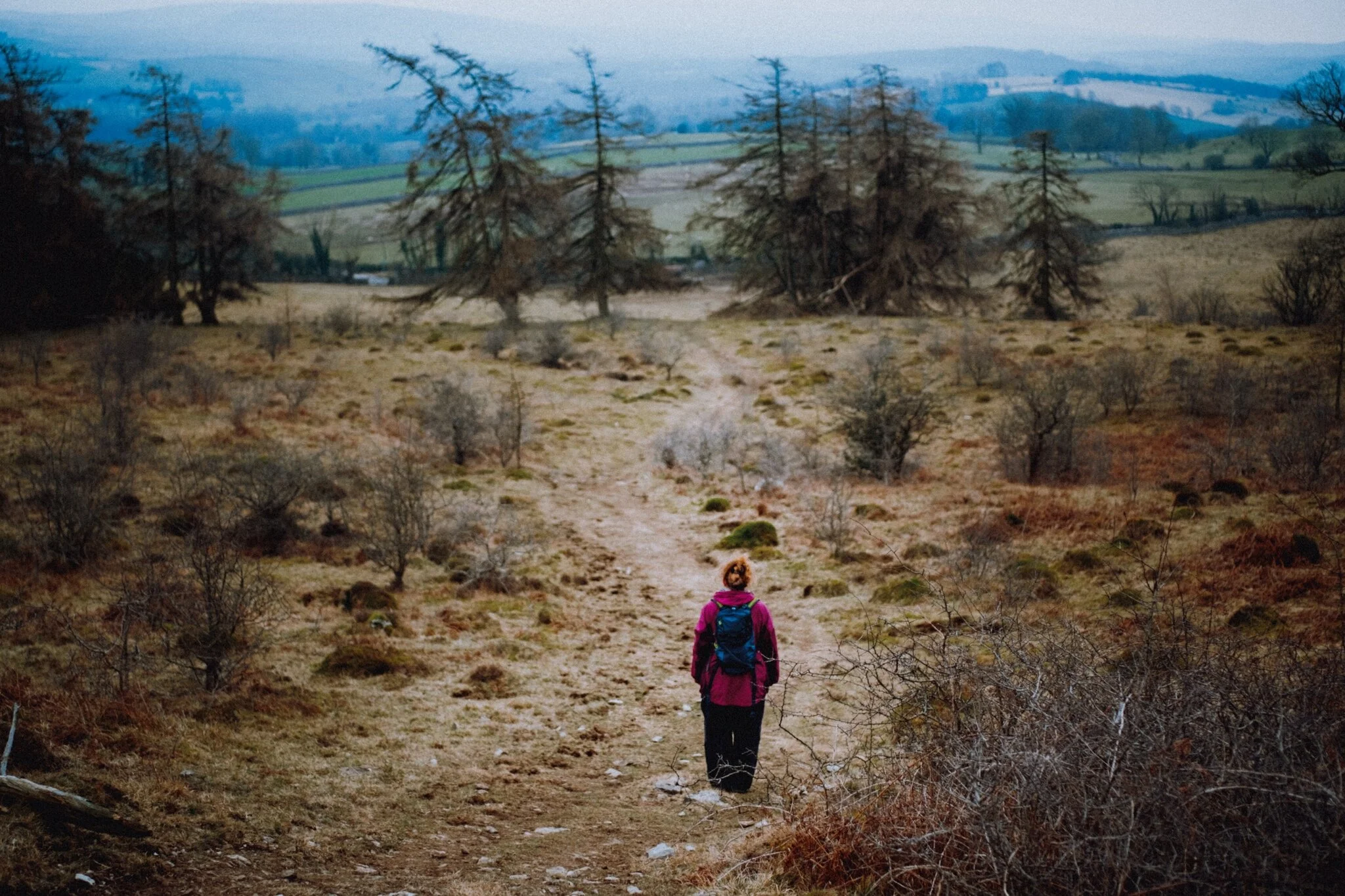
Lisabet drinking in the views south from Helsington Barrows. It was a rather hazy day.
The way towards Helsington Church.
A rather beautiful tree.
The textures of a particularly gorgeous and large oak in the grounds of Berry Holme Farm.
Holstein cows happily munching away. Won’t be long until they’re let out onto the fields.
The lane back down the valley. This is where we cross the A591 and heads towards Hawes Bridge.
Hawes Bridge. Never get sick of this place. Thankfully the limestone around the gorge was dry enough to get close to the falls.
The point where the River Kent is forced through a narrow limestone passage, gouging out a mini-gorge in the process. The water was super clear.
Don’t get too close to the ledges…
The other side of Hawes Bridge. This is was also our spot for a brief rest and an apple.
Further up the River Kent, where conditions are more calm. Plenty of sheep around too, and we’re starting to see lambs appear in the fields around here.
The way forward. Nearly back at Kendal.
Near Scroggs Wood there were plenty of Mallard ducks and swans milling about the river shore.
My first sighting of cherry blossom this year.
Pandemic Peregrinations: Mosedale, Lake District, Spring
My Dad’s been vaccinated.
My Dad’s been vaccinated.
This is a relief for me as Dad’s a Type II Diabetic and thus Clinically Extremely Vulnerable.
As he’s in our Support Bubble we went to check in on him this weekend, spending a large part of the day in the valleys of the Northern Fells near where he lives.
The Northern Fells is an area of the Lake District Lisabet and I have barely touched but we’re still starting to get round to it. South of Carrock Fell and Caldbeck Common, on Blencathra’s eastern flank, one can find two valleys ripe for hiking. On this occasion we picked Mosedale, and what a beautiful valley it is.
Mosedale is a west-east valley that begins life underneath Knott (710 m/2,330 ft) and its subsidiary top Coomb Height. Here the two rivers Grainsgill Beck and Blackhazel Beck join together underneath Knott and flow eastward, which has historically gouged out a steep valley with a flat floor.
The main path through the valley is on its southern flank, which gently ascends before reaching Bowscale Tarn. We chose the northern track through the valley this time, just to check out the scope of Mosedale. I think Lisabet and I will definitely return to hike the southern path.
The sun was out, white fluffy clouds were in the sky, a very light wind caressed our faces… it was a glorious day for a Lake District spring hike.
Photos taken on my Fujifilm X-T2 using my three lenses: a Samyang 35mm f/1.2, a Laowa 9mm f/2.8, and a Pentax SMC 55mm f/2.0. Developed using RNI’s Kodachrome film profiles.
I agree that this photo isn’t all that interesting, but I largely shot it to record probably Britain’s smallest footpath sign. Barely knee height!
Dad, with his own Fujifilm camera setup, enjoying the glorious sights and wonderful light conditions.
Our first real sight of the full extent of the Mosedale valley. Absolutely beautiful.
A composition shot across the valley towards Mosedale’s southern flank. Hidden by the “lip” near top-centre is Bowscale Tarn.
At Roundhouse, roughly halfway along Mosedale. Here the valley starts to pinch as we near the head towards Coomb Height, the fell in the distance on the right.
There’s quite a bit of scree around the head of Mosedale, including some sizeable boulders. This one caught my eye for the unusual patch of heather growing out of it.
I went for wee scramble off the track to nab a composition of some of the scree and vegetation.
As the valley pinches tighter the track runs right alongside the river, allowing for compositions straight down the cascades towards Coomb Height.
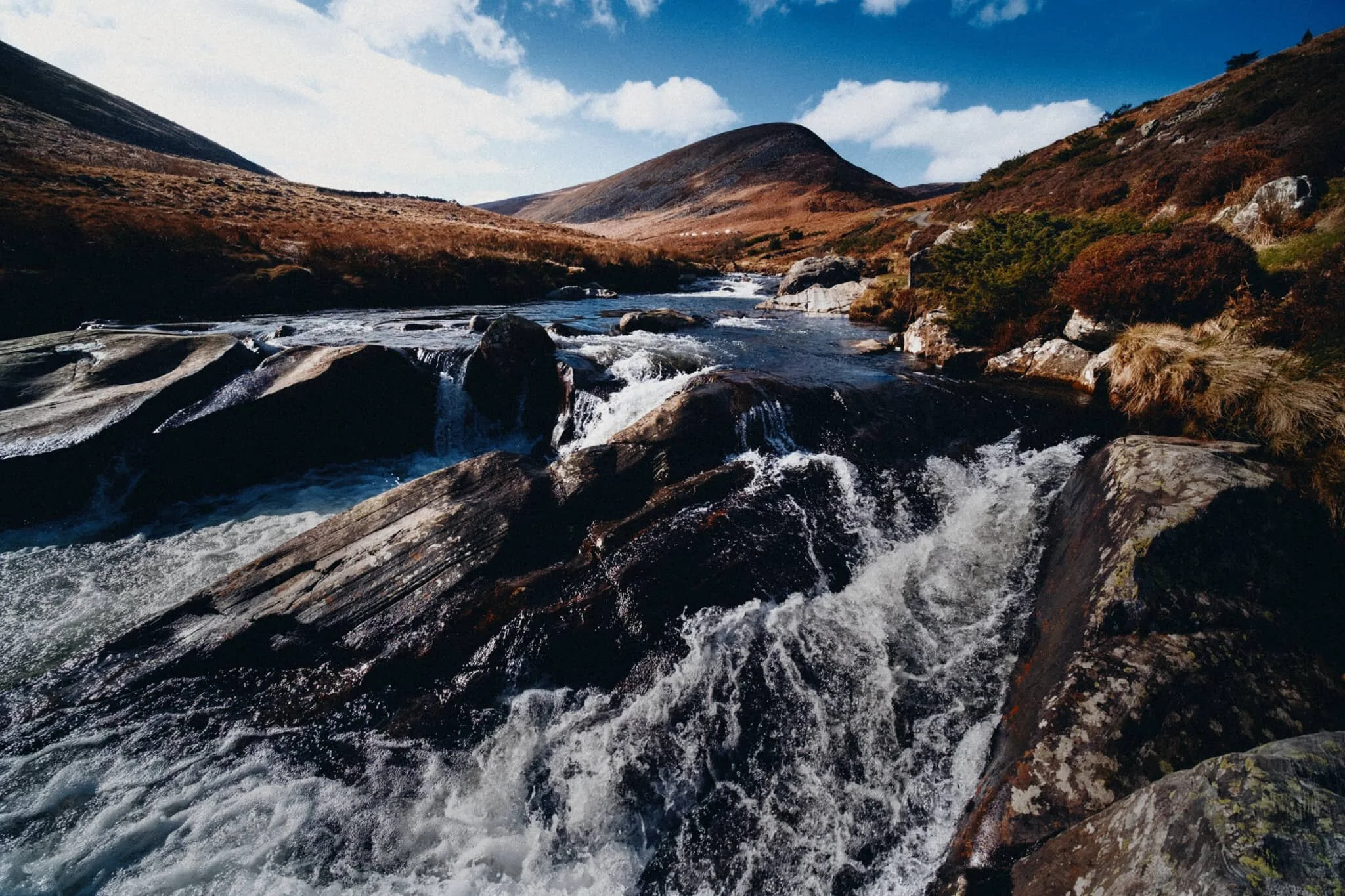
We found a particularly powerful section of the river as it gets forced between several large boulders. I went scrambling into the river to line up some compositions featuring Coomb Height, the river, and the textures of these gorgeous boulders.
A bit more precariously close to the fast rapids but arguably a better shot as a result.
One of those moments where it feels great to be out in nature.
Here we’d reached the head of the Mosedale, where Grainsgill Beck and Blackhazel Beck meet. This is Grainsgill Beck, which cuts out a gill on the northern side of Coomb Height. The fell to the right is Milton Hill. Grainsgill Beck saw a lot of mining activity in the 19th and 20th century.
Lisabet went seeking for the perfection composition of a particularly powerful cascade on Grainsgill Beck.
Back at the foot of the valley is Mosedale village, which is rather idyllic and a true Cumbrian rural paradise.
Mosedale village is almost impossibly quaint, complete with a red phone booth and a GR-era post box.
The long back to the car, crossing Mosedale Common and entering Caldbeck Common. Lisabet pulling way ahead, leaving me and Dad flagging behind. She’s got a proper good stride on her.

Pandemic Peregrinations: Lower Borrowdale, Lake District, Spring
The Four Step Plan to “normality” has been announced.
The Four Step Plan to “normality” has been announced by the government.
From the 8th March 2021 students will return to schools, colleges, and universities, and there will be a small loosening of social contact restrictions. Then from 29th March 2021 there is a further easing of social contact restrictions, primarily around meeting people outside. Outdoor sporting recreation will be allowed again, and you can start to travel within the country.
Step 2 from the 12th April 2021 sees non-essential business opening once again.
By 17th May 2021, Step 3 reduces even more restrictions on social contact, with most legal restrictions on outdoor meetings being lifted (except for gatherings of over 30 people).
And finally, by 21st June, all social contact restrictions will be lifted and all remaining businesses will be free to trade again.
At least, that’s the plan. Apparently guided by “data not dates”. Let’s see what happens.
In the meantime, Lisabet and I drove 9-miles north for a wander down the lovely Lower Borrowdale valley. We had intended to ford the river and take the public bridleway up and over Borrowdale Edge into Bretherdale, a valley we’ve never explored before. In any case, that didn’t happen; the stepping stones to ford the river had a sizeable gap right in the middle, and there was no way we were jumping across.
Instead, we simply enjoyed a valley bottom walk, all the way from the head of Lower Borrowdale to where it joins the Lune Gorge and the M6 motorway that runs through it.
All in all, about a 16 km hike, 24,000+ steps.
And lots of photos.
Photos taken on my Fujifilm X-T2 using my Samyang 35mm f/1.2, Laowa 9mm f/2.8, and my new Pentax SMC 55mm f/2.0 lens (a vintage lens from the 70s that my Dad recently got me). All developed using RNI’s Kodachrome film profiles.
Our arrival at Lower Borrowdale saw misty fells, with cloud cover clinging to the fell tops. Fortunately these conditions didn’t last long and the sun soon started to burn away the morning mist.
A local farmer making his way back out of the valley after feeding some his flock up on Borrowdale Edge.
The way down to the bottom of Lower Borrowdale. The rather vertiginous looking fell in the distance is Greenside Crag (485 m/1,591 ft).
Plenty of Swaledales about, giving us The Look.
Looking back at Greenside Crag as the sun finally breaches the cloud cover and strikes across the face of the fell.
Still plenty of water about in the valley, with lots of puddles giving me an opportunity to snap some reflections. Here’s one of Winterscleugh (464 m/1,523 ft).
After an unsuccessful attempt to find a way to the Bretherdale public bridleway via the northern side of Lower Borrowdale, we decide instead to simply walk the valley all the way to its exit at the Lune Gorge.
At least the smaller becks were full of water.
A dilapidated old barn next to trees covered in unusually bright lichen.
Swaledales wearily guarding their food. The sweet summery scent of hay was wonderful.
Swaledale higher up the fellside.
There were some wonderfully gnarly trees up the fellside of Lower Borrowdale.
These two trees had some wonderful shapes to my eye, so I got my ultra wide 9mm lens out for a more unusual composition.
A dead tree providing some wonderful textures.
Down the green lonnin (lane) to the Lower Borrowdale farm. Glorious sunshine.
Plenty of chickens about at Lower Borrowdale farm. Very friendly and inquisitive creatures.
A farm “shop”.
A male mallard and his harem head back to the safety of Lower Borrowdale farm.
That’s right. A curving drystone wall. I can’t resist.
Up the wooded lane where the Lower Borrowdale valley exits out into the Lune Gorge.
The Howgills in the distance finally make an appearance, our signal to turn back.
A pretty bridge with the Whinfell Common fells in the distance.
A proper idyllic farmyard scene.
Probably my favourite shot of the bunch. Swaledales enjoying the hay feed, my lovely Lisabet striding ahead, and the fells beyond. Lovely. Spring is coming.