
Stanley Ghyll Force, Lake District, Spring
After a sobering return from a beautiful week in the Highlands, it was time for a beautiful little jaunt in Eskdale.
After a sobering return from a beautiful week in the Highlands, it was time for a beautiful little jaunt in Eskdale.
I was also due to hang out with me Dad again. After arriving at Dad’s, he suggested checking out Stanley Ghyll Force, one of the Lake District’s largest waterfalls. I were game for that!
Stanley Ghyll Force is located in Eskdale, a gorgeous valley in the southwestern corner of the Lake District. The last―and only―time I visited Stanley Ghyll Force was back in 2017. I know this because I shot the waterfall with a Sigma dp0.
Back then, I was all on me own attempting to navigate a tricky gorge. However, on that occasion, I was able to get right to the bottom of the falls for some cracking.
A lot has changed in the intervening 5-6 years. For a start, you can’t get to the bottom of the falls anymore. The path has eroded and collapsed to the point that it’s too dangerous. Instead, the Lake District National Park have created an alternative route that scales up the sides of the gorge so that you can get above the falls. In addition, they’ve also cut back hectares of invasive rhododendron and constructed a fantastic viewing station above the gorge.
We enjoyed some fantastic light, and I had a grand day out with me Dad.
All photos taken on my Fujifilm X-T2 using my Vivitar “Series 1” 28‒105mm f2.8‒3.8 zoom, Super Ozeck 80mm‒210mm f4.5 zoom, and Laowa 9mm f2.8 ultra-wide prime lenses. RAWs developed in Capture One for iPad, edited in Affinity Photo 2 for iPad.
Stanley Ghyll Force, Lake District, Spring by Ian Cylkowski is licensed under CC BY-NC-SA 4.0![]()
![]()
![]()
![]()
The gorge that contains Stanley Ghyll Force is wonderfully mossy and vibrant. Here, a pocket of light illuminates a boulder field exposed in the woodland.
We passed a small tributary beck that was catching some wonderful light in the gorge.
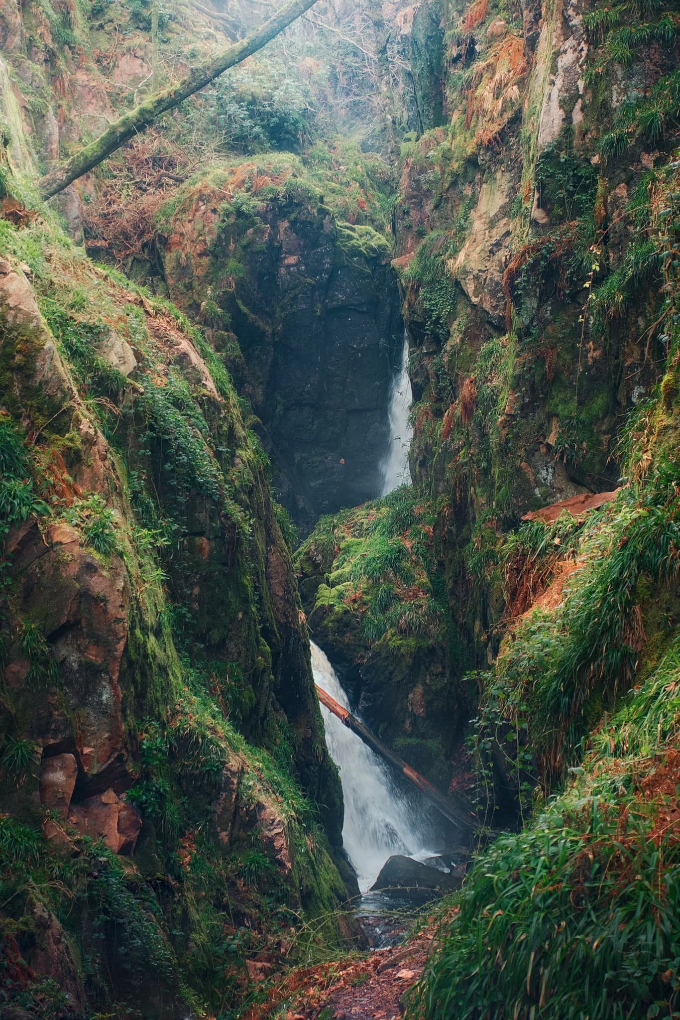
Eventually, the glory of Stanley Ghyll Force came into view. This was as close as we were allowed to get to it. Still some absolutely crackin’ light flooding into the gorge though.
After hiking up the new path made by the National Park, we found the new viewing station to check out the views it offered. And… wow. A sheer 150ft drop pulls your down the gorge and towards Stanley Ghyll Force. What a sight.
We followed the return track back down to the valley. As we did, me and Dad spotted some incredible light playing out on the distant Eskdale fells, and stopped to shoot photos like crazy.
Did you like these photos?

Mallerstang & Smardale, Cumbria, Summer
The British summer heatwave has arrived.
The British summer heatwave has arrived.
I took the opportunity for a long overdue stay over at my Dad’s, so that we could enjoy a lovely wander in the glorious British sunshine during the weekend.
After considering the potential busyness of the Lake District and Yorkshire Dales, we agreed to two outings: the first in the beautiful Mallerstang valley, and the second in Smardale.
Technically Mallerstang falls in the Yorkshire Dales these days, but it is often ignored in favour of some of Dales’ more popular southern hotspots. Smardale, especially Smardale Gill, is a remote and deep valley just outside Kirkby Lonsdale. It features a gorgeous viaduct crossing the valley, the Smardale Gill Viaduct.
In between each excursion, we visited Kirkby Stephen for delicious food.
A crackin’ weekend.
All photos taken on my Fujifilm X-T2 using my Vivitar “Series 1” 28–105mm f2.8–f3.8 zoom and my Laowa 9mm f/2.8 prime. RAWs developed in Capture One for iPad, finished in Affinity Photo.
Mallerstang
Parking up near Aisgill in Mallerstang, I can never ignore this road’s view towards Wild Boar Fell.
Not a bad view if you’re on the Settle–Carlisle line, eh?
Our goal on this hike around Mallerstang was to get onto the Pennine Bridleway and eventually towards the Water Cut sculpture. Along the way, we diverted to get a view of Hell Gill Force, which with the lack of rain looked rather pitiful.
Happy cows staring quizzically at us from across the beck.
A dry Hell Gill Beck reveals the riverbed formations its been carving. Further up the beck as you go up the fellside, the river has cut an impressive gorge that I’d like to explore one day.
Various parts of the Mallerstang valley have been fenced off from livestock, allowing meadows to flourish full of flowers.
Up on the Pennine Bridleway! This is a section of the bridleway known as A Pennine Journey, once walked and described by famed walker Alfred Wainwright.
An oystercatcher (Haematopus ostralegus), unusually high up and inland compared to its preferred breeding grounds near the coast.
As well as oystercatchers, and plenty of sheep, circling above us were Northern Lapwings (Vanellus vanellus), noisily warding us away from their chicks/nest.
Our destination comes into view, and the panorama starts to open up.
This sculpture, found on the Pennine Bridleway, is called “Watercut” by Mary Bourne. The watery gap that divides the sculpture utilises the changing sky to echo the ever-changing flow of water.
It’s hard to resist playing with the cut for photographic compositions.
Across the valley, Wild Boar Fell rises steeply into the sky at 2,323 ft (708 m) high.
The Pennine Bridleway continues down the valley, with Mallerstang Edge above. We elected to trace our footsteps back to the car.
Swarth Fell and the many gills that cut into its fellside.
Smardale Gill
After refuelling with drink and food at Kirkby Stephen, we parked up at Smardale to walk through the nature reserve towards the epic Smardale Gill Viaduct.
Flies followed and pestered us all the way. Nevertheless, Dad managed to spot and nab a superb photo of a toad, and we finally reached the viaduct, granting us views such as this.
Smardale Gill Viaduct was built in 1861, crossing the Pennines to carry coke to the iron and steel furnaces in the Barrow area and West Cumberland. It carried the railway 90 feet (27m) high above the valley and was constructed of locally quarried sandstone. The viaduct has 14 arches of 30 feet span, and a total length of 553 feet (c170m).
High above us, passing clouds created gorgeous gradients of light and shadow across the fellsides.
In the distance is Green Bell, one of the Howgills near Ravenstonedale.
The line was closed in 1962, after British steelmaking finished. For over twenty years the viaduct stood disused, deteriorating from lack of maintenance and exposure to the weather. British Rail wanted to demolish it but instead Eden District Council listed it. In 1989 the Northern Viaduct Trust was setup and in the Autumn of 1992 it was formally handed over to the Trust as a permissible footpath. It has required repair work numerous times since, and still does.
Did you like these photos?
Mallerstang & Smardale, Cumbria, Summer by Ian Cylkowski is licensed under CC BY-NC-SA 4.0![]()
![]()
![]()
![]()