Pendragon & Lammerside Castles, Mallerstang, Yorkshire Dales, Winter
If the weather’s not going to improve, time to go somewhere that suits it.
If the weather’s not going to improve, time to go somewhere that suits it.
Regular readers of this site may know that Mallerstang, technically part of the Yorkshire Dales, is one of my favourite places in Cumbria. Typically my hikes in the valley explore the region south of Wild Boar Fell. However towards the northern part of the valley, as it starts to flatten out, one can find a historical gem: Pendragon Castle.
Unbeknown to both myself and Lisabet, there is another castle ruin further north of Pendragon, known as Lammerside Castle. So, we picked out a hike we could do that would take in both Pendragon and Lammerside Castles, and perhaps also check out Wharton Hall.
Although the forecast suggested skies would brighten up as the day went on, above Mallerstang the sky was resolutely cloudy and grey. No biggie. It just added to the mood of the scenes.
All photos taken on my Fujifilm X-T2 using my Vivitar “Series 1” 28–105mm f2.8–3.8, Super Ozeck 80–205mm f4.5, and Laowa 9mm f2.8 lenses. RAWs converted in Capture One for iPad, developed in RNI Films, finalised in Affinity Photo 2 for iPad.
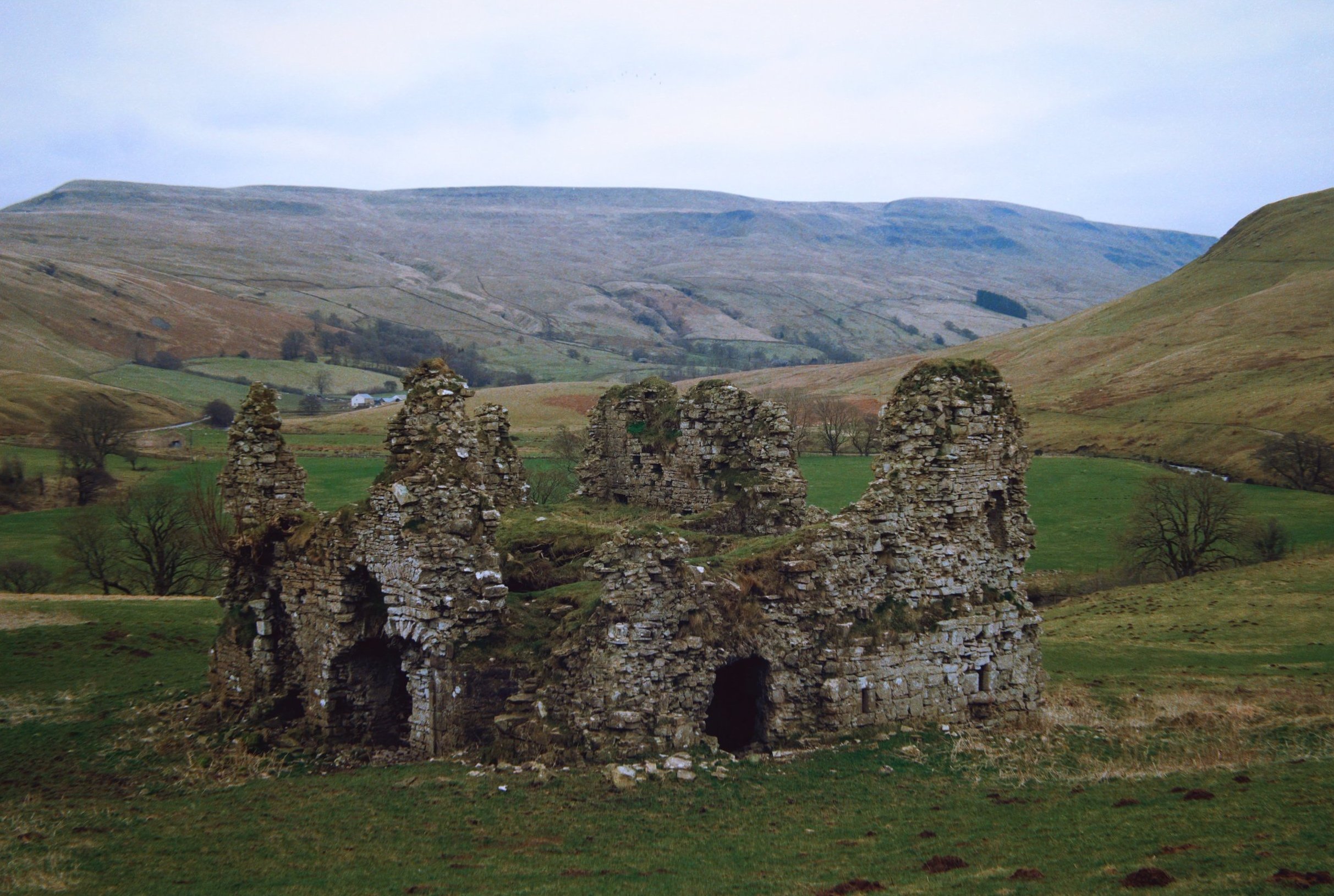
The ruins of Pendragon Castle, looking particularly moody with the bare branches eerily pointing towards it.
It’s been about a decade since I last explored the ruins of Pendragon castle. This was in the prime of HDR days, where I didn’t go anywhere without a tripod and shot almost exclusively with an ultra-wide lens. With experience and developed eyes, I could spot compositions I’d never seen before.
Zooming in tighter, I pick out a delightful composition involving the crumbling ruins of Pendragon castle framing the shapely peak of Wild Boar Fell.
Circumnavigating the ruins, I look for compositions involving the ruins and the fell on the other side of the valley, Mallerstang Edge.
Legend says that the castle was built by Uther Pendragon, father of King Arthur. More accurately, the castle was built in the 12th century by Ranulph de Meschines, a Norman magnate.
A winding drystone wall leading to a fell? I couldn’t say no…
Even better if it’s a winding drystone wall involving castle ruins.
Following the Pennine Bridleway towards Lammerside Castle, I equip my 80–205mm lens for long tele shots of the distant Northern Pennines.
Eventually the ruins of Lammerside Castle come into view, seemingly not as grand as Pendragon Castle.
In the valley below us, sheep mill about aimlessly. One in particular spots me and gives me a good hard stare.
By the River Eden, swimmers warm up after a spot of outdoor swimming in what must be an icy cold river.
Scanning around and above the ruins, I can see incredible compositions revealing themselves to me.
The winner from the day. Some of the 2nd storey of the ruins survive, but nature is quickly reclaiming it. In the distance, Mallerstang Edge lines the top of the frame.
Time to slap on the 9mm ultra-wide. The closest crumbling wall looks like a human head, don’t you think?
The largest surviving archway into the ruins. I didn’t want to risk heading inside though.
This was about as far as I dared venture into the ruins. Amazing that the stonework has survived this long.
Compared to Pendragon Castle, not much is known about Lammerside Castle. It was probably built, similarly, in the 12th century but considerably fortified in the 14th century to protect against Scots raiders.
I could easily bang my head against the top of this archway. Makes you realise how much smaller people used to be.
Above Wharton Hall as we turned to head back, Lisabet quickly made friends with the local horses.
At Bullghyll farm, a friendly chicken hops up onto the wall for a friendly greeting.
A meandering beck snakes down from Birkett Knott above.
Following the Pennine bridleway back to Pendragon Castle, the magnificent peak of Wild Boar Fell makes its presence known once again.
Gnarly trees beautifully frame Cocklake Barn as we near the return to Pendragon Castle, 16,000 steps later.
Did you enjoy these photos?

Mallerstang & Smardale, Cumbria, Summer
The British summer heatwave has arrived.
The British summer heatwave has arrived.
I took the opportunity for a long overdue stay over at my Dad’s, so that we could enjoy a lovely wander in the glorious British sunshine during the weekend.
After considering the potential busyness of the Lake District and Yorkshire Dales, we agreed to two outings: the first in the beautiful Mallerstang valley, and the second in Smardale.
Technically Mallerstang falls in the Yorkshire Dales these days, but it is often ignored in favour of some of Dales’ more popular southern hotspots. Smardale, especially Smardale Gill, is a remote and deep valley just outside Kirkby Lonsdale. It features a gorgeous viaduct crossing the valley, the Smardale Gill Viaduct.
In between each excursion, we visited Kirkby Stephen for delicious food.
A crackin’ weekend.
All photos taken on my Fujifilm X-T2 using my Vivitar “Series 1” 28–105mm f2.8–f3.8 zoom and my Laowa 9mm f/2.8 prime. RAWs developed in Capture One for iPad, finished in Affinity Photo.
Mallerstang
Parking up near Aisgill in Mallerstang, I can never ignore this road’s view towards Wild Boar Fell.
Not a bad view if you’re on the Settle–Carlisle line, eh?
Our goal on this hike around Mallerstang was to get onto the Pennine Bridleway and eventually towards the Water Cut sculpture. Along the way, we diverted to get a view of Hell Gill Force, which with the lack of rain looked rather pitiful.
Happy cows staring quizzically at us from across the beck.
A dry Hell Gill Beck reveals the riverbed formations its been carving. Further up the beck as you go up the fellside, the river has cut an impressive gorge that I’d like to explore one day.
Various parts of the Mallerstang valley have been fenced off from livestock, allowing meadows to flourish full of flowers.
Up on the Pennine Bridleway! This is a section of the bridleway known as A Pennine Journey, once walked and described by famed walker Alfred Wainwright.
An oystercatcher (Haematopus ostralegus), unusually high up and inland compared to its preferred breeding grounds near the coast.
As well as oystercatchers, and plenty of sheep, circling above us were Northern Lapwings (Vanellus vanellus), noisily warding us away from their chicks/nest.
Our destination comes into view, and the panorama starts to open up.
This sculpture, found on the Pennine Bridleway, is called “Watercut” by Mary Bourne. The watery gap that divides the sculpture utilises the changing sky to echo the ever-changing flow of water.
It’s hard to resist playing with the cut for photographic compositions.
Across the valley, Wild Boar Fell rises steeply into the sky at 2,323 ft (708 m) high.
The Pennine Bridleway continues down the valley, with Mallerstang Edge above. We elected to trace our footsteps back to the car.
Swarth Fell and the many gills that cut into its fellside.
Smardale Gill
After refuelling with drink and food at Kirkby Stephen, we parked up at Smardale to walk through the nature reserve towards the epic Smardale Gill Viaduct.
Flies followed and pestered us all the way. Nevertheless, Dad managed to spot and nab a superb photo of a toad, and we finally reached the viaduct, granting us views such as this.
Smardale Gill Viaduct was built in 1861, crossing the Pennines to carry coke to the iron and steel furnaces in the Barrow area and West Cumberland. It carried the railway 90 feet (27m) high above the valley and was constructed of locally quarried sandstone. The viaduct has 14 arches of 30 feet span, and a total length of 553 feet (c170m).
High above us, passing clouds created gorgeous gradients of light and shadow across the fellsides.
In the distance is Green Bell, one of the Howgills near Ravenstonedale.
The line was closed in 1962, after British steelmaking finished. For over twenty years the viaduct stood disused, deteriorating from lack of maintenance and exposure to the weather. British Rail wanted to demolish it but instead Eden District Council listed it. In 1989 the Northern Viaduct Trust was setup and in the Autumn of 1992 it was formally handed over to the Trust as a permissible footpath. It has required repair work numerous times since, and still does.
Did you like these photos?
Mallerstang & Smardale, Cumbria, Summer by Ian Cylkowski is licensed under CC BY-NC-SA 4.0![]()
![]()
![]()
![]()

Mallerstang, Yorkshire Dales, Autumn
One of my favourite things to do is to show my Dad new places to hike and photograph.
One of my favourite things to do is to show my Dad new places to hike and photograph.
So on Sunday my Dad came down to visit and we headed out to Mallerstang—perhaps my favourite Yorkshire Dales valley—for a hike full of vistas, beautiful light, and pretty waterfalls.
I think, judging from his exclamations, he rather enjoyed it.
All shots taken on a Fujifilm X-T2 with a Fujinon XF 18–55mm f/2.8–4.0 lens using a customised Classic Chrome film profile.
Hell Gill Force, finally with a good bit of water flowing.
The beautiful profile of Wild Boar Fell (708 m/2,323 ft) with some clear late-afternoon light streaking across it.
We took a route through Mallerstang that I’d personally never done before, from Hell Gill Force and up onto Slade Edge, which is a small limestone plateau that rises above the middle of the valley.
Slade Edge offers wonderful vistas, both towards Wild Boar Fell on the western side and Mallerstang Edge on the east. Here, my eye spies a meandering drystone wall and I can’t resist the photo.
We got some delightful light shows on this hike. The expansive views of Mallerstang, with Angerholme Wold on the left and Mallerstang Edge on the right. In the distance, the North Pennines.
Across the valley to the gashes and crags of Wild Boar Fell, with High White Scar on the left and The Nab on the right, both towering above Aisgill Farm.
A solitary barn near Hanging Lund, below the slopes of Mallerstang Edge. Sunlight escaping from between the clouds scans across the fellside.
Back near Cotegill Bridge, I took this shot of the Settle-Carlisle railway line with Wild Boar Fell above. I then realised that I were surrounded by parked cars and plenty of people, setting tripods and cameras and step ladders. Why? Probably trainspotters, waiting for a steam train coming down the line.
A nice little waterfall near Cotegill Bridge, with some rather vivid yellow spongey moss everywhere.
Last light of the day, and probably my best shot.

Mallerstang, Yorkshire Dales, Spring
We set out for a hike recently in the expansive and quiet valley of Mallerstang, in the northwestern corner of the Yorkshire Dales.
It’s getting hot in here.
The MetOffice confirmed that Spring 2020 has been the sunniest UK spring on record. By 27th May, Spring in the UK had already recorded 573 hours of sunshine, beating the previous record set in 1948 of 555.3 hours.
We set out for a hike recently in the expansive and quiet valley of Mallerstang, in the northwestern corner of the Yorkshire Dales. The day started out overcast and cooler, so we originally planned out quite a long route, hiking up towards the Pennine Bridleway to get the views and check out the Bridleway’s sculptures. But soon the clouds cleared, the temperatures rose to around the mid-20s, and the wind died so we broke the hike in half.
Mallerstang is a favourite of ours. It tends to get overlooked by many folk, who are often attracted to the main honeypots of the Yorkshire Dales, such as Ingleton’s waterfalls or the Ribblehead Viaduct. Mallerstang is a fairly long valley, about 6 miles long, and features two prominent ridges on each side of the valley: Mallerstang Edge (660 m/2,165 ft) to the east and Wild Boar Fell (708 m/2,323 ft) to the west, both distinctively flat-topped and beautifully sculpted. The valley’s also full of fascinating waterfalls including Hellgill Force, the biggest one.
All photos shot on a Fujifilm X-T2 with a 16–50mm f/3.5–5.6 lens using a customised Classic Chrome film simulation.
The Settle-Carlisle railway line travels through Mallerstang. Would love to take a train ride along this scenic route some day. A simple composition, utilising the rail track as a leading line to point straight towards Wild Boar Fell.
Hellgill Force, normally a thundering roar, reduced to a couple of rivulets dribbling down to the gorge.
Further up Hell Gill Beck the views really open up looking towards Wild Boar Fell.
Up on Pennine Bridleway, our goal is in sight. Overhead the clouds dissipate and we clearly make out the escarpment of the Northern Pennines.
This sculpture, found on the Pennine Bridleway, is called “Watercut” by Mary Bourne. The watery gap that divides the sculpture utilises the changing sky to echo the ever-changing flow of water. To the right is the flat-topped Mallerstang Edge.
It’s a brilliant concept.
Looking down the Pennine Bridleway as it descends into Mallerstang. One day, we’ll finish the route.
The sky clears, the temperatures rise, but we’ve made back to the road towards the car. A classic Yorkshire Dales composition featuring a narrow road, dry stone walls, and a shapely fell.