
Ambleside, Lake District, Winter
Temperatures have plunged.
Temperatures have plunged.
The nigh persistent rain of November and December has given way to a sub-zero climate and clearer conditions. Much better.
With a bright Saturday forecast, Lisabet and I ventured into the heart of the Lake District and major tourist hotspot, Ambleside. We wanted to do two walks: one, a small circular of Stock Ghyll Force, the other bigger hike up to High Sweden Bridge.
Despite being in the middle of a blisteringly cold winter in the Lake District, Ambleside was as busy as ever. This town never gets any rest.
All photos taken on my Sony α7ii using my SMC Pentax-M 28mm F3.5 and SMC Pentax-M 55mm f2.0 prime lenses, plus my Vivitar “Series 1” 70–210mm f2.8–4.0 zoom. RAWs developed in Lightroom, edited in Photoshop.
Ambleside, Lake District, Winter by Ian Cylkowski is licensed under CC BY-NC-SA 4.0![]()
![]()
![]()
![]()
A misty shot from the top of Stock Ghyll Force. Made by stacking five landscape 28mm shots, top to bottom, for a wider field of view.
The classic view of Stock Ghyll Force, currently in its more barren winter finery.
After stopping for delicious hot brews at Force Cafe, we followed the trail back down to the town. By the side of the road, this still life-esque scene revealed itself to me, and so quickly I quickly nabbed a composition.
From the town centre, it’s easy enough to find the route to the High Sweden Bridge trail. Given the direction of the low sun, we opted instead to take the trail anti-clockwise, which we’ve never done before, to get more side light.
The old packhorse bridge itself, with my Lisabet providing a nice colour contrast as she strolls across it. As I’ve mentioned on this site elsewhere, the name “High Sweden Bridge” might seem unusual, given this is located in the Lake District, England. The “sweden” aspect originally comes from the Old Norse sviðin (pronounced “swee-thin”), the past participle of svíða, meaning “to burn” or “to singe”. In this context, it refers to the clearing of land by burning.
Looking up Scandale, admiring the light beams scanning across the face of High Pike (656 m/2,152 ft).
Heading back down the higher eastern side of the Scandale valley, I equipped my 70–210mm lens for some tight and distant compositions. Fully zoomed in, I was able to pick out the mist clearing from the summits of the Langdale Pikes, on the right, and Bowfell on the left.
My 70–210mm also has a macro mode, which I used to try and capture these beautiful and tiny Cladonia pyxidata lichen.
Lake District sheep get all the best views.
Did you enjoy these photos?
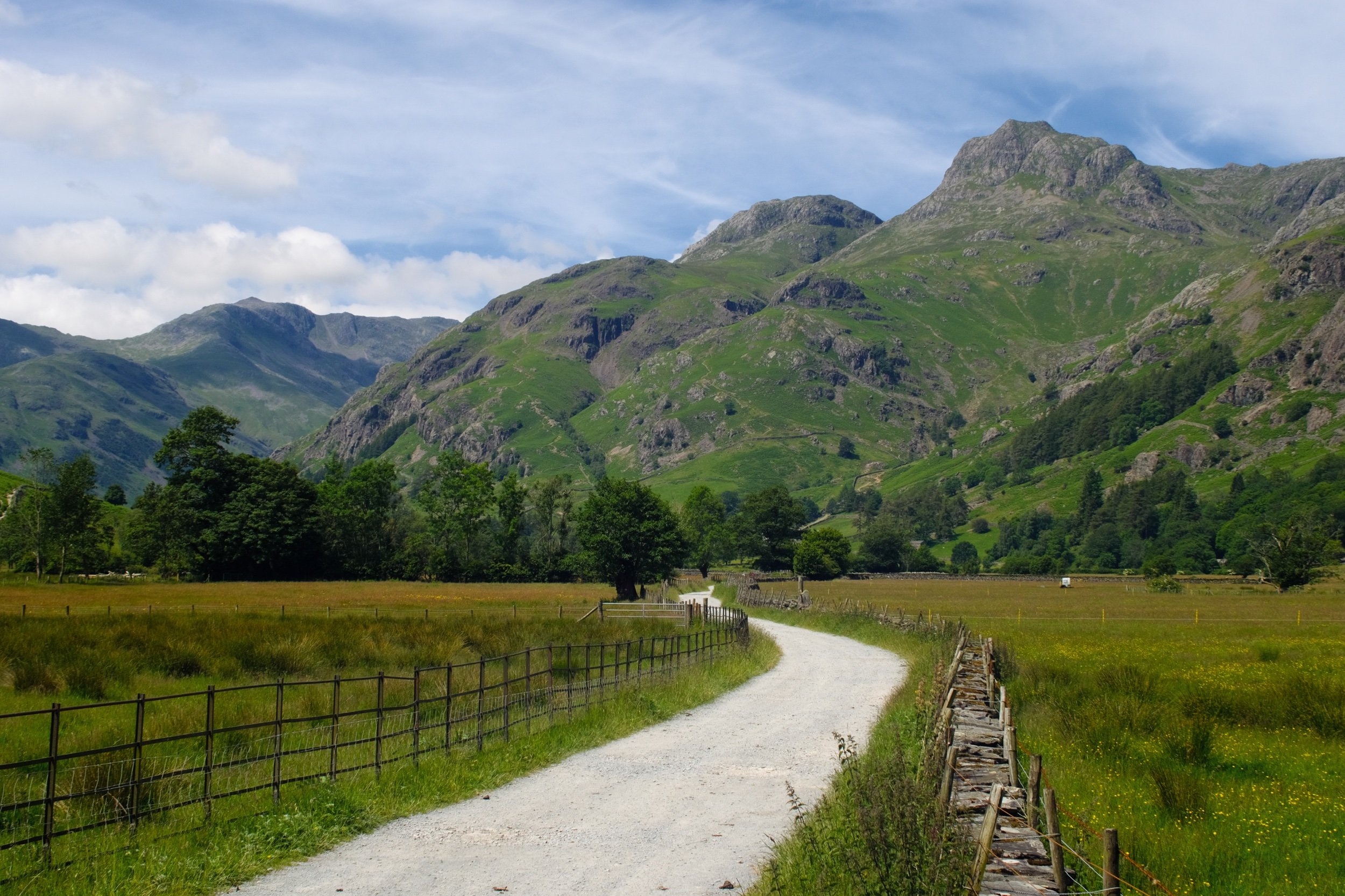
Great Langdale, Lake District, Summer
It has been far too long since I’ve been to Great Langdale.
It has been too long since I’ve been to Great Langdale.
In fact, from what I can make out, the last time I visited Great Langdale was November 2020. That’s bad.
And a shame. Great Langdale is one of my favourite places in the whole of the Lake District.
Thankfully I have some time off whilst I transition between jobs, and the UK summer is in full swing. It was time to reacquaint myself with some of the Lake District’s most recognisable peaks.
Great Langdale did not disappoint. My goodness.
All photos shot on my Fujifilm X-T2 using my Vivitar “Series 1” 28–105mm ƒ/2.8–3.8 zoom lens. Images made 90% in-camera using the Velvia film simulation, finished off in Affinity Photo.
I managed to get some parking at the LDNPA’s official car park, right in the heart of the Great Langdale valley. Merely stepping out of the car park offers you scenes like this.
A true Lake District scene: towering craggy fells, stone walls and cottages, green grass, Herdwick sheep.
There were plenty of ewes and their lambs freely milling around the roads and lanes in the valley.
The first leg of the hike I wanted to explore was to head east towards Oak Howe. This part of Great Langdale is heavy with summer meadows and at this time of the year they’re brimming with flowers. Plus, you get panoramas like this.
I threw my lens wide open and got down low to snap the Langdale Pikes high above the fields and fields of buttercups.
Oak Howe cottage, with Oakhowe Crag towering above, itself a subsidiary top of Lingmoor Fell.
One of my favourite spots in Great Langdale, shot near Oak Cowe cottage next to Great Langdale Beck. The Langdale Pikes looking as epic as ever.
For the second leg of the hike, I traced my steps back west, capturing compositions of the Langdale Pikes along the way.
The fist-like crags of the Langdale Pikes to the right, Bowfell to the left.
Whitegill Crag stands protectively over the valley floor and its inhabitants.
Rossett Farm with Thorn Crag and Loft Crag above, like axe heads thrust into the sky.
The western aspect of Great Langdale features its highest fells, accessible via the fell in the middle of this photo known as “The Band”. To the left is Crinkle Crags (859 m/2,818 ft) and to the right is Bowfell (902 m/2,959 ft).
Some kind of rose, I think? I couldn’t tell you which one but it were pretty, just sitting there in the hedgerow.
As I head closer to Stool End Farm, Pike o’ Blisco (705 m/2,313 ft)—south of Crinkle Crags—makes its presence known.
A pied wagtail (Motacilla alba yarrellii) sits atop a drystone wall long enough for me to focus and nab this shot.
A side valley that branches off the main Great Langdale valley, Mickleden, features this great wall of rock known as Rossett Crag, peaking at Rossett Pike (651 m/2,136 ft).
The road to Stool End Farm, which marks the beginning of many popular ascents up to the likes of Bowfell, Crinkle Crags, and beyond.
The western aspect of the Langdale Pikes peaks at Pike o’ Stickle (709 m/2,326 ft), before dropping sharply down to the valley floor.
Heading back east towards the car, this part of the Langdale Pikes is very popular with rock climbers who fancy tackling some tricky climbs.
I love this place.
Did you like these photos?
High Sweden Bridge, Lake District, Spring
It was nice to get a bit of altitude.
It was nice to get a bit of altitude.
I think the last time we hiked the High Sweden Bridge circular was back in June of 2020, just as the UK was starting to come out of the first COVID-19 Lockdown. Wow. Time flies, eh?
With this weekend due to continue its favourable weather conditions, we followed Saturday’s hike around Brough Castle with a longer, more strenuous hike up to High Sweden Bridge in Scandale, above Ambleside. I tell you something: it was so good to finally see the Lakeland fells clearly.
All photos shot on my Fujifilm X-T2 using my Fujinon 23mm f/2.0 and my adapted Pentax SMC 55mm f/2.0 prime lenses. Images developed in RNI Films’ Velvia 100F film profile.
On this occasion we elected to park at one of the free lay-bys before you get into Ambleside proper. This would give us a few extra 1,000 steps or so.
Wansfell Pike (486.9 m/1,597 ft) above Ambleside, clear as a bell in the beautiful light.

We soon found the steep lane that climbs up into Scandale, and the views quickly improved from “This is pretty” to “Bloody hell!”
On the way up, a cute little Robin (Erithacus rubecula) made its presence known to us atop a drystone wall. Didn’t fly or away or anything. Happy to chill and let us take photos.
Soon, High Pike came into our sight, lit up like a beacon in the spring Lake District sun.
Higher and higher the trail went. Astonishingly clear views towards Rydal Water, Loughrigg, Silver How, and the Langdale Fells were enjoyed.
My lovely Lisabet, perched on the ancient packhorse bridge known as High Sweden Bridge.
After crossing High Sweden Bridge, it was time to ascend up the Scandale fell side in order to find the ridge that let back down into Ambleside.
The full extent of Scandale opened up before us. On the eastern side of the valley, a minor footpath continues up the valley to link with Scandale Pass, which takes you onto Kirkstone Pass should you so wish.
When crossing the stile, I paused at the summit of the climb to snap this obvious composition of the drystone wall leading all the way to High Pike.
The Coniston fells come back into view after finding the open ridge back down into Ambleside.
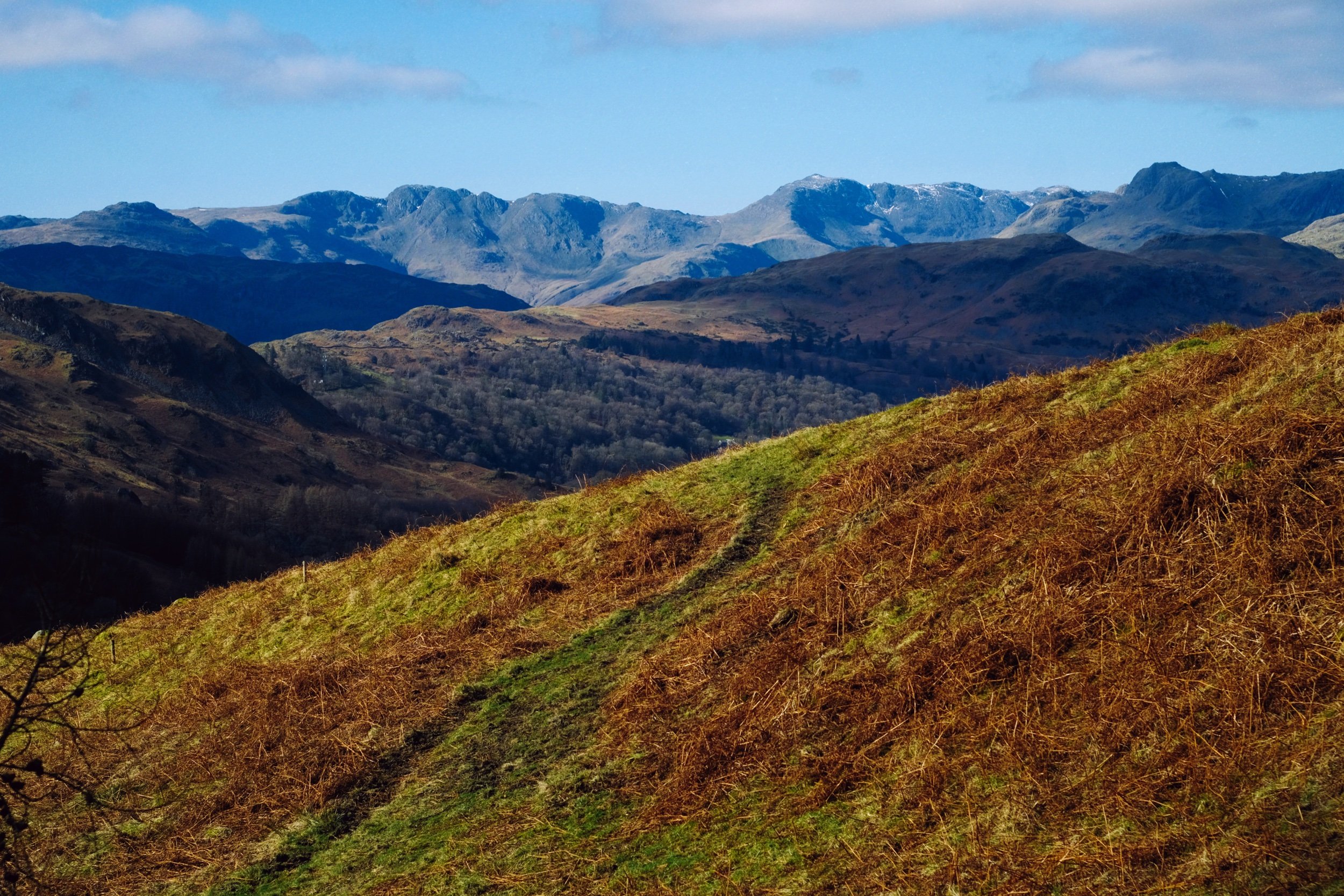
The wonderfully craggy profile of the Langdale Pikes, Bowfell, and Crinkle Crags.
A minor sheep track branches off the main trail, heading towards Nab Scar. The skyline of the fells is impossible to resist a photo.
One last peek at the Langdale Pikes before we drop down the fellside into Ambleside.

The long ridge of Wetherlam sinks beneath the bulk of Loughrigg as we descend.
What a fantastic and bizarre looking tree.

Near Low Sweden Bridge, a flock of young Kendal Rough Fells peacefully graze on the new grass.
What a crackin’ day.