
Trotternish Peninsula, Isle of Skye, Scotland, Spring
The last series of photos from our Skye spring 2024 trip.
The last series of photos from our Skye spring 2024 trip.
There’s a part of me that doesn’t want to post these, because it concludes in a way that we’re no longer on Skye.
And that is always painful.
For this post, I’ve assembled a rag-tag of photos taken from around Skye’s Trotternish peninsula that didn’t really fit in with other posts. This includes:
Duntulm Bay, with the epic ruins of Duntulm Castle perched on top of cliffs of volcanic sill
The ridiculously clear views we got from near the Flodigarry coast, across the sea to the Torridon mountains on the mainland
I hope you enjoy these photo as much as I enjoyed seeing and taking them.
All photos shot on my Sony α7ii using my Pentax SMC 28mm F3.5 prime lens and Vivitar “Series 1” 70–210mm f2.8–4.0 zoom lens. RAWs developed in Lightroom, then edited and finalised in Photoshop.
Trotternish Peninsula, Isle of Skye, Scotland, Spring by Ian Cylkowski is licensed under CC BY-NC-SA 4.0![]()
![]()
![]()
![]()
The epic ruins of Duntulm Castle, perched on top of basalt cliffs nearly 100ft above the surf. Southwest of the ruins, the coast is made of volcanic sill intrusions, criss-crossing joints that make for wonderful compositions.
Further west away from the castle ruins we could even spot across the sea here, known as the Little Minch, the islands of Lewis and Harris. I couple of crystal clear rock pools helped me create some sort of coherent composition from the chaos of rock joints.
Closer to the castle ruins, the sun broke out from the clouds above the Quiraing, giving fantastic side light to this scene. These ridged tufts of grass made for a nice compositional leading line into the scene.
From Flodigarry, above Loch Langaig, a small ruin made for a nice composition, mimicking the shape of the distant mountains.
We were astounded when stopping at Flodigarry to see crystal clear views across the sea towards the Torridon mountains on the mainland. So clear you almost felt you could reach out and touch the mountains.
Further along the mainland, the unmistakable shape of Slioch (“the spear”), above Loch Maree, is immediately apparent, standing 3,219 ft above the sea.
Did you enjoy these photos?

Sleat Peninsula, Isle of Skye, Scotland, Spring
Skye’s Sleat peninsula often gets overlooked.
Skye’s Sleat peninsula often gets overlooked.
It’s understandable why. When the island contains wonders such as the Cuillins, the Quiraing, the Storr, the Fairy Pools and more, why would you go to the extreme south/south-west of the island?
In my experience, Sleat is where you take photos from, not of. While the peninsula does have some lovely coastline, arguably it’s finest aspect is the views you can get from its southern and northern shores.
Looking south across the Sound of Sleat one can enjoy immense views of the Knoydart mountains, such as Ladhar Bheinn, Meall Buidhe, and Luinne Bheinn.
Over the peninsula onto its northern shores, Sleat harbours beautiful beaches and craggy coastlines, punctuated by bonny little crofting settlements, such as Tarskavaig, Tokavaig, and Ord. These places get unparalleled views across Loch Eishort towards the entire Cuillins range.
My advice: Give yourself a day to explore Sleat. You won’t regret it.
All photos taken on my Sony α7ii using my Rokinon 14mm f2.8 ED AS IF UMC and Pentax SMC 28mm F3.5 prime lenses, and my Vivitar “Series 1” 70–210mm f2.8–4.0 zoom lens. RAWs developed in Lightroom then edited and finalised in Photoshop.
Sleat Peninsula, Isle of Skye, Scotland Spring by Ian Cylkowski is licensed under CC BY-NC-SA 4.0![]()
![]()
![]()
![]()
Just north of Armadale there’s a stretch of coastline known as Bàgh a' Mhuilinn (“Bay of the Mill”). Here, one can play around with incredible rock formations and the Knoydart mountains in the distance.
The geology around Armadale is largely comprised of Lewisian Gneiss, which are some of the oldest rocks on Earth; roughly 3.0–1.7 billion years old! In the distance the main peak in the Knoydart is Ladhar Bheinn (“peak of the hoof”).
From near Armadale you can take the single-track winding road over the Sleat peninsula towards its northern shores. Along the way, though, magnificent views of the Cuillins reveal themselves. We stopped to nab some photos from above Loch Dhùghaill because who can say no to this?!
Arriving at Tarskavaig Bay, Lisabet and I quickly wandered off to explore and photography. I found this fascinating person-high crag on the beach, and clambered within its nooks and crannies looking for compositions. These are Lewisian Gneiss again, but have been squashed and stretched so much that they've become very fine-grained and have lots of cracks. They also have minerals like chlorite and epidote in them.
Away from the massive crag I head towards the more expansive beach, with fantastic clear views towards the Cuillins. I find another otherworldly rock formation and seek to compose along with the winding channels towards the Cuillins.
Moving on from Tarskavaig, we continue up the northern shore of Sleat to Tokavaig. At Tokavaig Bay, one can find the ruins of Dùn Scaich castle, formerly owned by Clan MacDonald of Sleat, a branch of the Clan Donald or MacDonald. With my long zoom lens, I can really compress the distant views, capturing the ruins of the castle as well as the mighty Blàbheinn mountain in the distance.
Dùn Scaich castle sits atop a crag on the Tokavaig coast, given near 360 views of its surroundings. It would’ve once been possible to enter the ruins across the arched footpath, but the floor of it has collapsed. The fortress is alternatively referred to as the "Fortress of Shadows." It is famously associated with the legend of the warrior woman Scáthach, who is said to have resided there, giving the castle its name.
Further long the coastline from the castle ruins are several sheer cliffs that offer unimpeded views across Loch Eishort to the entire Cuillins range. Here, my Lisabet stands perilously close to the edge of one cliff, providing a sense of scale.
The view you can enjoy from Tokavaig’s cliffs. The small trio of islands in the loch are called Eilean Ruairidh, translating as “Isle of the Red King”. There was once a fort here too. From this view, it’s clear to view the geological differences between the Black Cuillins, towards the left, and the Red Cuillins towards the right. The Red being smoother and made of granite, and the Black being more jagged and made of gabbro.
Further along the coastline we arrive at Ord, where one can take the minor road back over the Sleat peninsula to its southern shores. Before we did, we explored the bay here too. At Ord, you can find crags on the beach where old rocks meet some younger rocks called quartzites, and the younger rocks are found underneath the older ones, which is a bit unusual. The quartzites have some cool features, like cross-bedding (patterns in the rock) and folding (where the rock has been bent).
From Ord I once again equipped my 70-210mm zoom lens for some tighter compressed compositions. I lined up the small rocky islands just off the bay to lead towards the Strathaird coastline and Blàbheinn looming above everything.
Did you enjoy these photos?
Barnard Castle, County Durham, Spring
Apologies for the delay since my last post.
Apologies for the delay since my last post.
Things have been on the change again, personally. Also, this last week I’ve endured a rather nasty stomach bug. The less said about that the better.
A couple of weekends ago, Lisabet and I decided to move away from countryside-based adventures and check a wee little town you may have heard of (if you’re British and follow the news): Barnard Castle.
The charming historical town gained unfortunate notoriety in 2020 when Dominic Cummings, the chief advisor to the British Prime Minister, was found to have traveled there with his family during the first UK lockdown of the COVID-19 pandemic. Given his close contact with the infected Prime Minister, Cummings was at a substantial risk of carrying the virus himself (he exhibited symptoms the following day). Media accusations of violating lockdown rules emerged, to which Cummings explained that he had driven to the town to test his eyesight in order to reassure his wife of his ability to drive them back to London the next day.
Regardless of all of that, Barnard Castle sits in a beautiful area, which we explored to also take in the sights of the ruins of Eggleston Abbey.
A moody day for photography.
All photos taken on my Fujifilm X-T2 using my Vivitar “Series 1” 28–105mm f2.8–3.8 zoom and Laowa 9mm f2.8 prime lenses. RAWs developed in Capture One for iPad, edited and finalised in Affinity Photo for iPad.
Barnard Castle, Country Durham, Spring by Ian Cylkowski is licensed under CC BY-NC-SA 4.0![]()
![]()
![]()
![]()
The circular round tower of the Barnard Castle itself, one of the main features of the ruins that still stands. Daffodils lined the path around the ruins on a moody day.
Barnard Castle, the town, is chock-full of yards (alleys) like this, which always draw my eye for a photo.
We found the streets of Barnard Castle to be well kept, with plenty of independent shops and eateries, occasionally peppered with some more mainstream brands.
Below the castle ruins this handsome bridge caught a sliver of golden afternoon light.
We followed the country road from Barnard Castle to Egglestone Abbey. The moody and changeable day followed us. Here a table-tomb pointed towards some of the last standing walls of the abbey ruins.
The abbey was constructed in the late 12th century by Premonstratensian monks. Like all other abbeys in England, it was dissolve din 1540 by King Henry VIII’s Dissolution of the Monasteries.
These days the ruins are in the custody of English Heritage, and access is free. I highly recommend a visit if you’re ever in the area.
Did you like these photos?
Pendragon & Lammerside Castles, Mallerstang, Yorkshire Dales, Winter
If the weather’s not going to improve, time to go somewhere that suits it.
If the weather’s not going to improve, time to go somewhere that suits it.
Regular readers of this site may know that Mallerstang, technically part of the Yorkshire Dales, is one of my favourite places in Cumbria. Typically my hikes in the valley explore the region south of Wild Boar Fell. However towards the northern part of the valley, as it starts to flatten out, one can find a historical gem: Pendragon Castle.
Unbeknown to both myself and Lisabet, there is another castle ruin further north of Pendragon, known as Lammerside Castle. So, we picked out a hike we could do that would take in both Pendragon and Lammerside Castles, and perhaps also check out Wharton Hall.
Although the forecast suggested skies would brighten up as the day went on, above Mallerstang the sky was resolutely cloudy and grey. No biggie. It just added to the mood of the scenes.
All photos taken on my Fujifilm X-T2 using my Vivitar “Series 1” 28–105mm f2.8–3.8, Super Ozeck 80–205mm f4.5, and Laowa 9mm f2.8 lenses. RAWs converted in Capture One for iPad, developed in RNI Films, finalised in Affinity Photo 2 for iPad.
The ruins of Pendragon Castle, looking particularly moody with the bare branches eerily pointing towards it.
It’s been about a decade since I last explored the ruins of Pendragon castle. This was in the prime of HDR days, where I didn’t go anywhere without a tripod and shot almost exclusively with an ultra-wide lens. With experience and developed eyes, I could spot compositions I’d never seen before.
Zooming in tighter, I pick out a delightful composition involving the crumbling ruins of Pendragon castle framing the shapely peak of Wild Boar Fell.
Circumnavigating the ruins, I look for compositions involving the ruins and the fell on the other side of the valley, Mallerstang Edge.
Legend says that the castle was built by Uther Pendragon, father of King Arthur. More accurately, the castle was built in the 12th century by Ranulph de Meschines, a Norman magnate.
A winding drystone wall leading to a fell? I couldn’t say no…
Even better if it’s a winding drystone wall involving castle ruins.
Following the Pennine Bridleway towards Lammerside Castle, I equip my 80–205mm lens for long tele shots of the distant Northern Pennines.
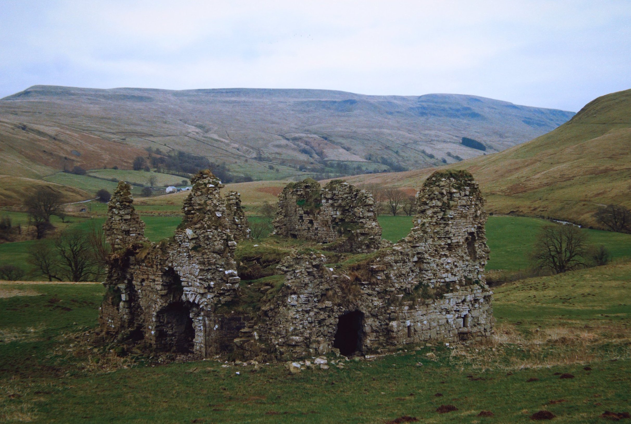
Eventually the ruins of Lammerside Castle come into view, seemingly not as grand as Pendragon Castle.
In the valley below us, sheep mill about aimlessly. One in particular spots me and gives me a good hard stare.
By the River Eden, swimmers warm up after a spot of outdoor swimming in what must be an icy cold river.
Scanning around and above the ruins, I can see incredible compositions revealing themselves to me.
The winner from the day. Some of the 2nd storey of the ruins survive, but nature is quickly reclaiming it. In the distance, Mallerstang Edge lines the top of the frame.
Time to slap on the 9mm ultra-wide. The closest crumbling wall looks like a human head, don’t you think?
The largest surviving archway into the ruins. I didn’t want to risk heading inside though.
This was about as far as I dared venture into the ruins. Amazing that the stonework has survived this long.
Compared to Pendragon Castle, not much is known about Lammerside Castle. It was probably built, similarly, in the 12th century but considerably fortified in the 14th century to protect against Scots raiders.
I could easily bang my head against the top of this archway. Makes you realise how much smaller people used to be.
Above Wharton Hall as we turned to head back, Lisabet quickly made friends with the local horses.
At Bullghyll farm, a friendly chicken hops up onto the wall for a friendly greeting.
A meandering beck snakes down from Birkett Knott above.
Following the Pennine bridleway back to Pendragon Castle, the magnificent peak of Wild Boar Fell makes its presence known once again.
Gnarly trees beautifully frame Cocklake Barn as we near the return to Pendragon Castle, 16,000 steps later.
Did you enjoy these photos?

Llansteffan, Carmarthenshire, South Wales, Autumn
Did you know that Wales is home to the most castles per square mile of any country in Europe?
Did you know that Wales is home to the most castles per square mile of any country in Europe?
Certainly during our stay in South Wales we visited our fair share of them, mostly in ruins, such as Dinefwr and Castell Carreg Cennen, and Llandovery castle.
Heading south towards Carmarthen Bay, where the Avon Twyi pours out into the Bristol Channel, one can find the sleepy little village of Llansteffan with yet another magnificent fort perched on a cliff top overlooking the bay. The village’s name means “Llan of St. Stephen”. You’ll find a lot of place names in Wales start with the prefix Llan; it refers to sanctified land occupied by Christian monks or communities, almost always named in honour of a Saint.
After checking out the ruins of Llansteffan Castle, we ambled along the beach below the castle, where I gawped and photographed the local geology.
All photos shot on my Fujifilm X-T2 using my Vivitar “Series 1” 28–105mm f2.8–3.8 zoom and Laowa 9mm f2.8 prime lenses. RAWs converted in Capture One for iPad, then developed and finalised in Affinity Photo for iPad.
Llansteffan, Carmarthenshire, South Wales, Autumn by Ian Cylkowski is licensed under CC BY-NC-SA 4.0![]()
![]()
![]()
![]()
A rather shapely tree that caught my eye on the way up to Llansteffan Castle.
From outside the castle ruins the views overlooking Carmarthen Bay were rather splendid.
The ruins of Llansteffan Castle. It sits on the site of a much older Iron Age fort, showing that Llansteffan has been inhabited for millennia.
The Normans built a castle here in the 12th century. Like a lot of castles here in South Wales it passed hands often between the Welsh and the English. By the 14th century it was described as being in a poor state.
One thing that struck in particular about these ruins were all the wasps. They were everywhere, tucked into various nooks and crannies of the stonework.
We braved the disconcerting hum of wasps all around us to explore this building for a composition whilst the light was particularly sympathetic.
Down on the beach below the castle, things were thankfully a lot more peaceful.
Historical glaciation and millennia of coastal erosion from the sea have exposed millions of years of geology history. Here Llansteffan would’ve been at various times a desert, at the bottom of a sea, and everything in between, with different rocks forming and deposited at various stages. Fascinating.
To quote Natural Resources Wales: “The bedrock geology of this area […] is dominated by Devonian Old Red Sandstone characterised by mudstones, siltstones, sandstones and conglomerates which were deposited in fluvial environments, such as meandering channels and floodplains. The rocks around Llansteffan include important exposures of calcrete (which is a fossil soil indicative of an arid or semi-arid environment). Overlying the Old red Sandstone is a classic sequence of Carboniferous rocks including shallow-marine carbonates (Carboniferous Limestone), shallow-marine and fluvio-deltaic deposits (Millstone Grit), and lacustrine, delta plain sediments and coal (Coal Measures).”
The exposure of Old Red Sandstone is clearer towards Scott’s Bay, where plenty of people were chilling with their pets, nestled into the crags.
I was beguiled by the shapes, forms and colours of the cliff rocks. Imagining the millions of years of this land, and how different the local landscape would’ve looked, makes my head spin!
A tighter composition reveals the joins and seems of various types of rocks as beautiful late afternoon light highlights the textures.
Llansteffan Castle and its dominating position above the village and the surrounding farmland.
Did you enjoy these photos?
The Castles of Lllandeilo, South Wales, Autumn
We’re in South Wales for a fortnight!
We’re in South Wales for a fortnight!
It feels great to relax and have a proper break from the severely challenging year we’ve had.
Arriving at our holiday property Friday evening—after a gruelling 5-hour drive in the lashing rain—we woke up Saturday deciding to explore the area nearby where we’re staying around Llandeilo.
Llandeilo is a small town on the western edge of the Brecon Beacons National Park. It’s proper bonny. Evidence of Roman occupation from around 74AD has been discovered here; later on, the settlement was named after a famous Celtic monk—Saint Teilo—with the Welsh word llan meaning a church or monastery, hence the name Llandeilo (pronounced Shan-DAY-loh).
Owing to the long and rich Christian and royal history in the area, there are lots of castles nearby. We explored just two of them: Dinefwr and Castell Carreg Cennen, both impressive in their own right.
After Friday’s insane amount of rain, conditions on the Saturday were thankfully dry and epic.
All photos shot on my Fujifilm X-T2 using my Vivitar “Series 1” 28–105mm f2.8–3.8 zoom and Laowa 9mm f2.8 prime lenses. RAWs converted using Capture One for iPad, developed and finished in Affinity Photo for iPad.
The Castles of Llandeilo, South Wales, Autumn by Ian Cylkowski is licensed under CC BY-NC-SA 4.0![]()
![]()
![]()
![]()
Dinefwr Castle
Below the Dinefwr estate woods, beautiful autumn light and foliage wraps this gorgeous house.
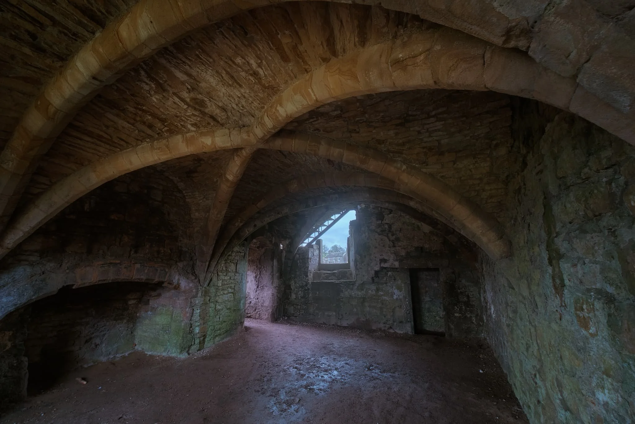
Inside the keep of Dinefwr Castle (pronounced din-EH-vor). The advantage of a 9mm ultra-wide lens is that you’re able to capture a massive field of view in tight compositional situations like this.
Despite being largely built in the 13th century, a lot of the castle is still standing tall and strong.
It’s easy to see why a castle was built here. It’s position on a hill allows for extensive views over the Twyi valley.
It’s possible to climb up the battlements for even more extensive and panoramic views. Autumn colours are just starting to appear in South Wales at the moment.
Up on the highest point of the ruins, looking over the battlements and keep across the Twyi valley on a cloudy and windy day. Truly moody.
The winding stairway leading up is narrow and challenging, especially as the steps themselves are smooth and insubstantial. Amazing how much smaller people were back then.
There’s been a castle at this site since the mid-12th century, but most of present ruins can be attributed to the work of Rhys Gryg in the early 13th century. The castle came into English hands by the end of the 13th century courtesy of King Edward I of England.
By the end of the 15th century the castle came into the hands of Sir Rhys ap Thomas, who began the process of rebuilding and improving the castle. Sir Rhys was a favourite of King Henry VII, largely due to Rhys’ crucial involvement in the Wars of the Roses.
In the distance to the right you can see the turrets of Newton House, built in the 17th century with massive renovations in the 19th century. Around the time of Newton House’s construction, Dinefwr Castle was modified to serve as a summer house.
The castle and its environment were relatively quiet, with most people opting to check out Newton House instead, further to the north. As such, Lisabet and I had ample opportunity to properly explore and photograph the site.
Within the Dinefwr Estate woodland, I spied some gnarly trees covered in moss and quickly sought to make a composition of this gorgeous scene.
The sun appeared from the clouds once again, bathing this house in the woods in autumnal light.
Newton House and its turrets, a wonderful autumnal and historic scene.
Castell Carreg Cennen
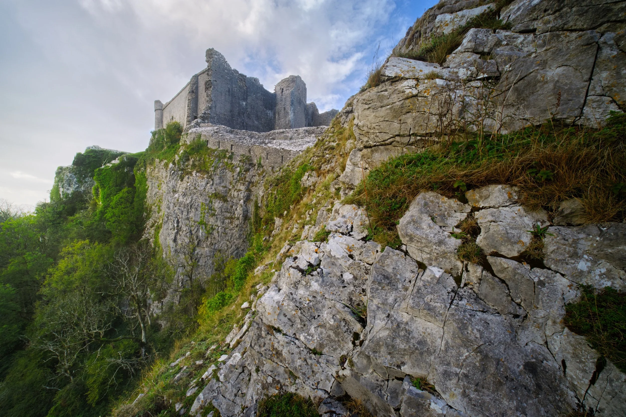
For our second trip for the day, we drove south east of Llandeilo into the Brecon Beacons National Park. Here one can find the impressive ruins of Castle Carreg Cennen, perched atop a high and might limestone crag above the River Cennen.
Rather then head straight into the ruins, Lisabet and I opted to scout around the shoulders of the crag. That’s how we found this ridiculous scene, with the castle perched on the limestone crag and a sheer 300ft drop down.
During our afternoon visit here the weather was much more inconsistent, alternating between brilliant bursts of light and sudden downpours. Whilst I was negotiating my way through the ruins, the sun once again burst through the racing clouds, illuminating this scene.
Castell Carreg Cennen was built in the 12th century, much like Dinefwr Castle, and similarly was claimed by the English through the conquest of King Edward I of England. These days the castle and its land is privately owned by the farm underneath it.
Frankly, one of the most stupendous and visually arresting castles I’ve ever seen.
Back at the farm beneath the castle ruins, a small herd of English Longhorn cows came to graze. Incredible creatures.
A beautiful shaggy coat with those imposing curling horns.