Durham, County Durham, Autumn
My first time in Durham.
My first time in Durham.
On the day of our anniversary proper, we woke up nice and early for a full day exploring the historical city of Durham.
I’d never visited the city before. Durham didn’t let me down. The day was bright and clear, bouncing golden light off Durham’s architecture, both modern and ancient.
Though our itinerary was kinda loose, a definite desire was to explore the epic Durham Cathedral, part of a UNESCO World Heritage site with Durham Castle.
Though our day was unfortunately cut short as I unexpectedly developed a stomach bug, what we did manage to see inspired to visit again.
All photos taken on my Sony α7ii using my Pentax SMC 28mm F3.5 and Rokinon 14mm f2.8 ED AS IF UMC prime lenses. RAWs were developed in Lightroom using Cobalt Image’s Sony profiles, with extra help from Photoshop and Photomatix.
Durham, County Durham, Autumn by Ian Cylkowski is licensed under CC BY-NC-SA 4.0![]()
![]()
![]()
![]()
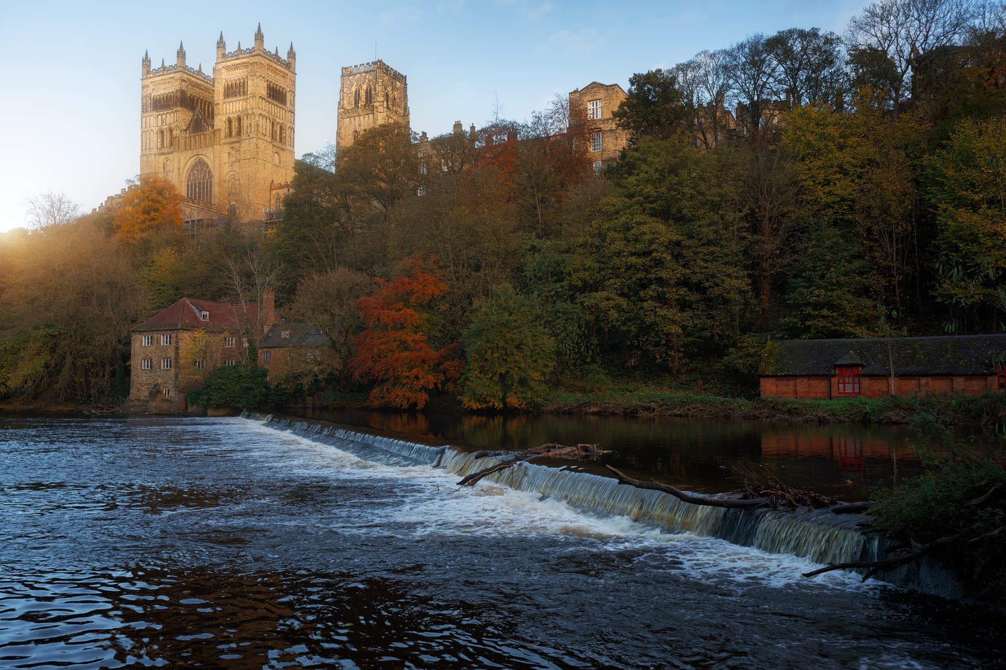
A weir at the River Wear. Clear and low autumnal light makes Durham’s buildings glow gold.
I moved into the shadows on Saddler Street, so I could pick out my compositions where the golden autumnal light was landing in interesting places. Saddler Street is one of Durham’s older roads, originally called Saddlergate.
Branching off Saddler Street is Elvet Bridge. There are numerous little “vennels”, or alleyways, that branch off Elvet Bridge. This was, Drury Lane, was home to a particularly picturesque cafe that we stopped for a brew at. I had to record this ridiculously timeless scene.
Soon we headed towards our main destination of the day: the massive Durham Cathedral, standing tall since the 11th century.
You enter the cathedral first via the Galilee Chapel. Constructed in 1170 CE, this part of the cathedral now serves as the resting place of St. Bede. Saint Bede (673-735) was an English monk and scholar renowned for his work Historia ecclesiastica gentis Anglorum, which provides invaluable insight into the history of Britain and the spread of Christianity among the Anglo-Saxon tribes.
After sorting out our entrance, we paid for the tower climb. Here you can ascend all 325 steps, 218 ft, to enjoy some immense views over Durham. I felt like a drone taking these photos! This is the view looking east.
The other side of the Central Tower gave us more extensive views looking west, pops of autumn colour here and there.
The nave of the cathedral, with its central ribbed vault obscured by the lighting fixtures assembled for an upcoming light show. The nave wouldn’t have looked much different compared to 900 years ago, except their wouldn’t be any seating.
Home to the Cathedra, the choir stalls, the organ, and the high altar, the Quire is where daily worship takes place.
This is the South Transept, from where you would access the Central Tower and climb its 325 steps. It features the Prior’s clock, constructed by Prior Castell in the late 15th or early 16th century.
The High Altar in the Quire. This would’ve been one of the earliest parts of cathedral to be constructed. Monks in the 11th century were seeking a place to hide from Vikings raids as they carried the relics of Saint Cuthbert.
The Chapel of the Nine Altars, built in the 13th century to accommodate the increasing number of pilgrims visiting the cathedral. Since St. Cuthbert’s shrine was seated here, Durham Cathedral has been an important place of worship for Christian pilgrims for centuries.
The Bishop’s Throne, built by Bishop Thomas Hatfield in the 14th century, with his tomb below it.
The light and stained glass windows around the Chapel of the Nine Altars was just astounding.
From around the Cloister, made more famous in modern times as one of the filming sets in the Harry Potter movies.

This is the Monks’ Dormitory, completed around 1404, and nowadays is home to the Cathedral Library, part of Durham Cathedral Museum. This was originally built as sleeping quarters for the Durham Priory monks.
The museum was truly fascinating and, much like the Faith Museum in Bishop Auckland, contained artefacts of faith and religious importance in the area from beyond Roman Times. This place lead to the Great Kitchen, which now houses a sacred part of the museum: Saint Cuthbert’s treasures and coffin.
Kingsgate Footbridge, completely resplendent in autumn colours. Our next goal was to locate the riverside footpath and take a wander along the river bend.
University boat racing was alive and well on the river as the sun began to set.
The woodland deep in the gorge was filled to the brim with incredible autumn colours.

From Prebends Bridge, the boat racing was in full flow, surrounded by vivid autumn foliage.
Putting Prebends Bridge in context of the river, the setting sun bursting from just above the trees.
And finally, Durham Cathedral from the riverside, catching the last of the light and glowing bright.
Did you enjoy these photos?
Bishop Auckland, County Durham, Autumn
An anniversary break.
An anniversary break.
Celebrating 11 years together, Lisabet and I enjoyed a lovely short break in County Durham area.
It’s a part of northern England that I guess can feel neglected or forgotten about. To the northwest you have the North Pennines and southwest are the Yorkshire Dales. Southeast is the North York Moors and further Northeast is the coast and Newcastle-upon-Tyne.
But there is an enormous amount of history in County Durham.
We stayed in Bishop Auckland, 10-minutes away from Durham. Bishop Auckland has a lot to offer, especially with the ongoing improvements courtesy of the ambitious Auckland Project. Upon arriving on the outskirts of the town, we head straight for its historic heart and took to exploring the Auckland Tower, the new Faith Museum, and the grounds of the castle.
We barely scratched the surface. But the just means more to explore for next time.
All photos taken on my Sony α7ii using my Pentax SMC 28mm F3.5 and Rokinon 14mm f2.8 ED AS IF UMC prime lenses. RAWs developed in Lightroom using Cobalt Image’s Fuji Classic Neg profile.
Bishop Auckland, County Durham, Autumn by Ian Cylkowski is licensed under CC BY-NC-SA 4.0![]()
![]()
![]()
![]()
Bishop Auckland Town Hall, with its unusual French-style mansard pavilions. It was opened in the mid-19th century, but by the 1970s it was abandoned then scheduled for demolition in the 1980s. Local campaigning saved the building and, after restoration work, it was reopened in the 1990s.
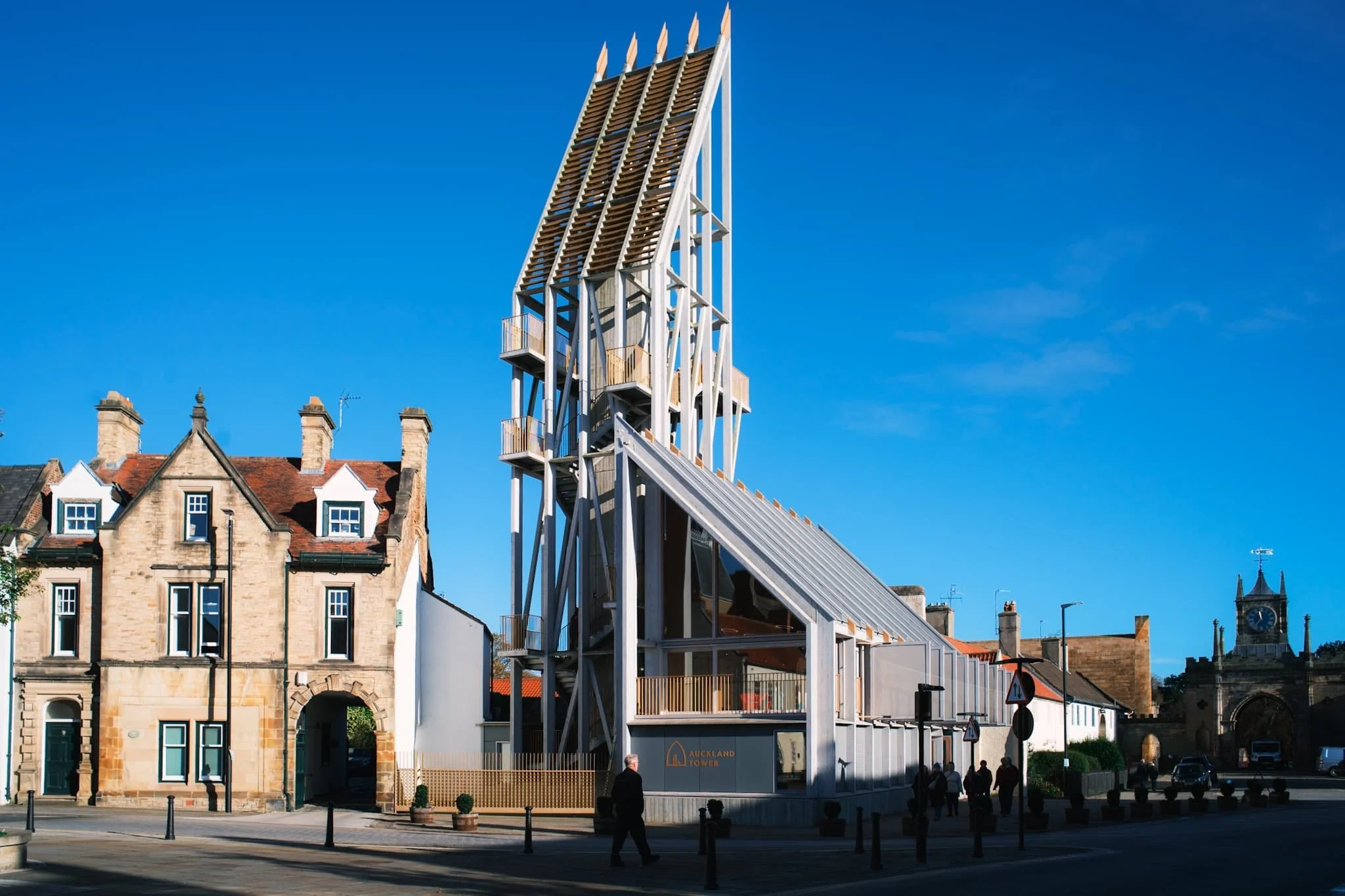
One of the new striking buildings courtesy of the Auckland Project. This is Auckland Tower. Its design is inspired by medieval wooden siege engines, which were propped against castle and fort walls to help invading armies breach defences. Adopting and inverting that same intention, the Auckland Tower borrows the design of those historic constructs to allow visitors to “breach” the castle’s history and allow people to freely explore.
A gallery on the 1st floor of the tower beautifully sets out the story and history of Bishop Auckland the surrounding area. The town was the seat of the powerful Prince Bishops of Durham since 1183 CE. Even before then, a Roman presence was in the area with a fort at nearby Binchester.
Visitors are encouraged to climb up the tower and enjoy the panoramic views on offer, which we duly did. St. Anne’s Church and the Town Hall are on the right, with the town centre through to the left.
From the top of the tower, a view to the east shows the castle gatehouse, built by Sir Thomas Robinson of Rokeby for Bishop William Trevor in 1760 CE. Beyond, the walled gardens and Auckland Park show the last of their autumnal splendour.
The grand entrance to the grounds of Auckland Castle. Inside the castle we paused for lunch in the new cafe, before seeking out the new Faith Museum.
The start of the journey into the Faith Museum. This place is fantastic, a real treasure for history geeks everywhere especially those who have an interest in the history of human faith. Being in County Durham, there is of course a lot of information about the beginnings and development of Christianity in the area, but there’s also heaps of artefacts and info about faith practised in the area during Roman times and before.
Punctuated along the main gallery were these wonderful archway tapestries that I couldn’t resist making a composition of.
Back outside, we soaked in the clear autumn air and explored the castle grounds.
We wandered around the town centre, where a different side of Bishop Auckland could be seen. Much like many other towns through the UK, the high street has seen better days. Hopefully, the Auckland Project will help rejuvenate things.
I love a pub with a mock Tudor facade. Though a pub has been on this site since the 16th century, this particular building was constructed in 1900.
Did you enjoy these photos?
Barnard Castle, County Durham, Spring
Apologies for the delay since my last post.
Apologies for the delay since my last post.
Things have been on the change again, personally. Also, this last week I’ve endured a rather nasty stomach bug. The less said about that the better.
A couple of weekends ago, Lisabet and I decided to move away from countryside-based adventures and check a wee little town you may have heard of (if you’re British and follow the news): Barnard Castle.
The charming historical town gained unfortunate notoriety in 2020 when Dominic Cummings, the chief advisor to the British Prime Minister, was found to have traveled there with his family during the first UK lockdown of the COVID-19 pandemic. Given his close contact with the infected Prime Minister, Cummings was at a substantial risk of carrying the virus himself (he exhibited symptoms the following day). Media accusations of violating lockdown rules emerged, to which Cummings explained that he had driven to the town to test his eyesight in order to reassure his wife of his ability to drive them back to London the next day.
Regardless of all of that, Barnard Castle sits in a beautiful area, which we explored to also take in the sights of the ruins of Eggleston Abbey.
A moody day for photography.
All photos taken on my Fujifilm X-T2 using my Vivitar “Series 1” 28–105mm f2.8–3.8 zoom and Laowa 9mm f2.8 prime lenses. RAWs developed in Capture One for iPad, edited and finalised in Affinity Photo for iPad.
Barnard Castle, Country Durham, Spring by Ian Cylkowski is licensed under CC BY-NC-SA 4.0![]()
![]()
![]()
![]()
The circular round tower of the Barnard Castle itself, one of the main features of the ruins that still stands. Daffodils lined the path around the ruins on a moody day.
Barnard Castle, the town, is chock-full of yards (alleys) like this, which always draw my eye for a photo.
We found the streets of Barnard Castle to be well kept, with plenty of independent shops and eateries, occasionally peppered with some more mainstream brands.
Below the castle ruins this handsome bridge caught a sliver of golden afternoon light.
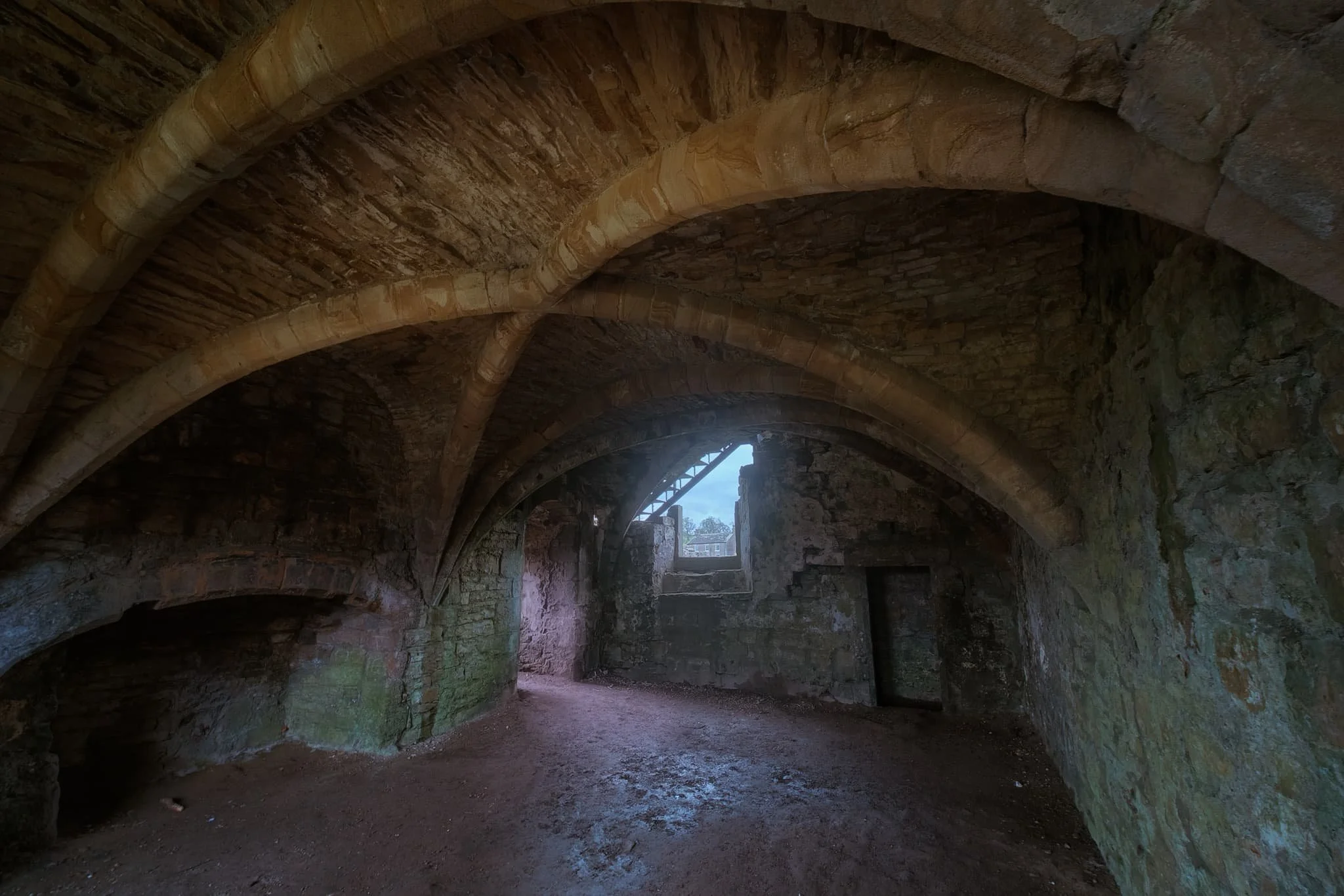
We followed the country road from Barnard Castle to Egglestone Abbey. The moody and changeable day followed us. Here a table-tomb pointed towards some of the last standing walls of the abbey ruins.
The abbey was constructed in the late 12th century by Premonstratensian monks. Like all other abbeys in England, it was dissolve din 1540 by King Henry VIII’s Dissolution of the Monasteries.
These days the ruins are in the custody of English Heritage, and access is free. I highly recommend a visit if you’re ever in the area.
Did you like these photos?
North Pennines Waterfalls, County Durham, Summer
Woohoo for a week off! With the Lake District as rammed as it is at the moment, let’s go somewhere a l’al bit different.
Woohoo for a week off! With the Lake District as rammed as it is at the moment, let’s go somewhere and l’al bit different.
The North Pennines AONB (Area of Outstanding Natural Beauty) is a favourite of ours but remains relatively untouched by us. We’ve explored arguably the jewel of the North Pennines, High Cup Nick, many times. But another absolutely stunning part of the area is the three main waterfalls: High Force, Low Force, and Cauldron Snout.
Long-time followers of this blog may remember our last excursion to High Force and Low Force, last year. The two waterfalls are a geology student’s dream and truly spectacular. But the third waterfall, Cauldron Snout, is often missed out on compared to the other two. That’s because it’s many miles further up the River Tees, near Cow Green Reservoir. Like High Force and Low Force, Cauldron Snout is the result of the outflow of Cow Green Reservoir passing over the whin sill; a layer of prehistoric super-hard dolerite volcanic rock that has left pillars and columns. The waterfall has eroded the softer rock around, leaving the harder columns of whin sill standing.
Cauldron Snout “only” drops about 60 m, all in all, but does so steeply down 180 m of the gorge, making it one of the longest waterfalls in England. The last time we visited it was many years ago in between Christmas and New Year, and a lot of the rock around the waterfall was covered in ice, making it a treacherous task to navigate. This time, we managed to scramble all the down alongside the waterfall. It was immense.
All photos shot on my Fujifilm X-T2 using my three prime lenses: a Samyang 35mm f/1.2, a Laowa 9mm f/2.8, and an adapted Pentax SMC 55mm f/2.0. Images developed using one of RNI Film’s Kodachrome profiles, finished in Affinity Photo.
Low Force is probably the easiest of the three to access, being less than a kilometre’s walk from the Bowlees Visitor Centre. Regardless, it’s an impressive sight and sound.
My lovely Lisabet, already on the case and getting some compositions in.
I clambered around the columns and cliffs of whin sill to get to the northern bank of the Tees for this view of the main falls of Low Force. The morning’s light was wonderful and I didn’t want to miss out.
The twin falls of Low Force. Not necessarily all that tall, but powerful and loud.
The conditions and light were beautiful. Not too harsh. Autumn’s definitely on the way.
One gentleman decided that a dip in the waterfall was in order.
Fair play to him.
The Pennine Way heads along this footbridge, which crosses the River Tees below. It’s an old ‘un, too, so all the signage requests people cross it one at a time.
The lower aspect of Low Force shot from the southern banks of the Tees after we crossed the bridge.
After I spotted this young lass climbing the statues, I think she looked rather… sheepish?
A tighter composition of the main falls of Low Force, trying to convey the sheer power of these waterfalls. The redness in the water comes from all the peat the river carries from the high moorlands of the North Pennines.
Looking back at the northern bank of the River Tees, with more people finding their now to the waterfalls. Best get a move on.
Lisabet doing her best to capture all the splendour around her.
Love all the signs of autumn starting to appear.
Looking forward to all the rusty colours of autumnal ferns.
After trekking the Pennine Way along the southern side of the River Tees, we crossed another old footbridge and took these steep steps up towards the road. A visit to High Force beckoned us.
The woodland above the Tees is still lush.
After paying our entrance fee (£2 per adult, very reasonable), we followed the path through the woodlands of the Raby Estate. Already, we could hear the booming sound of the giant waterfall, High Force.
The first glimpse of High Force and the gorge it’s created. The excitement builds…
And there she is, plunging 70 ft off a cliff into the deep pool below. What a sight.
We scrambled down to the boulder field left behind by the receding waterfall, each of us seeking our own photographic compositions of the waterfall.
Of course, mine predominately featured all the wonderful shapes of the boulders.
After thousands and thousands of years, as the waterfall carves its way back up the River Tees, it’s left behind boulder with fascinating shapes and textures.
Plenty of other folk were clambering around the boulders for better views of the awesome High Force.
Nature makes you feel closer.
Due to the COVID-19 Pandemic, the High Force trail is a one-way system now, so we hiked up the steep steps out of the gorge and navigated through the Raby Estate woods back to the car. My lovely Lisabet, looking as stunning as ever.
Upper Teesdale has a similar “feel” to a Yorkshire Dales valley, to me.
After a break for lunch, we drove a few miles west and parked at Cow Green Reservoir, seeking out Cauldron Snout. Along the way, views across the reservoir can be had of Meldon Hill (767 m/2,517 ft).
We crossed the dam for views over the reservoir and below to the Tees. Clouds of midges were out in full force.
Looking down onto the Tees from the top of the dam. You can just make out to the left the top of Cauldron Snout before it crashes down into the valley.
Cow Green Reservoir was constructed in the late 1960s to supply the industries of Teeside with a constant supply of water.
The reservoir essentially acts as a river regulator, ensuring the River Tees is always flowing with water even during dry conditions.
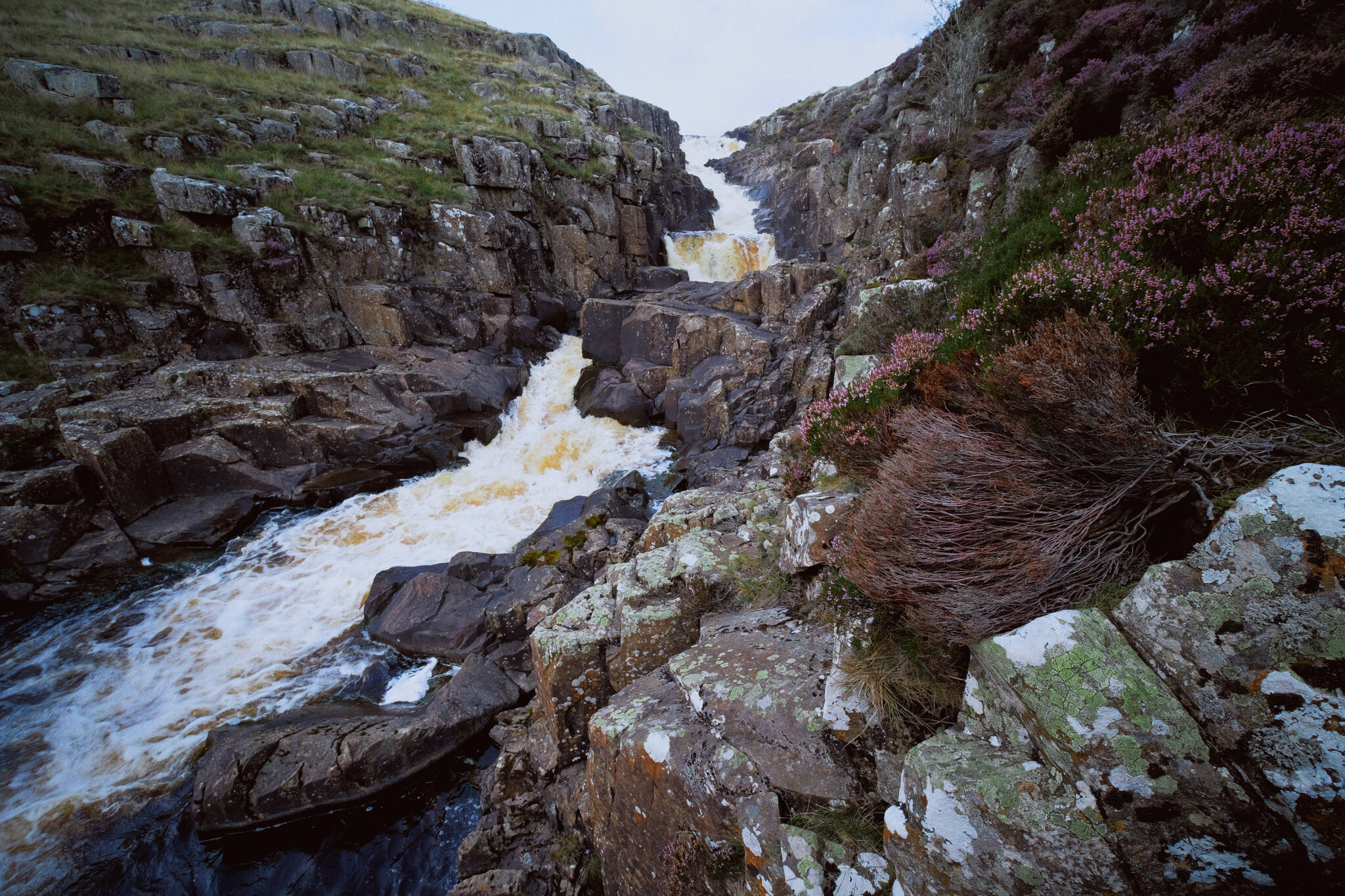
And here’s the top of Cauldron Snout. The Pennine Way is to left, but it isn’t really a “path” as such as navigating and scrambling down the side of the gorge created by the waterfall.
But doing so enables you to get right next to the falls for cracking views like this. A man perched at the top of the falls helps provide a sense of scale.
With the heather in bloom, they provided wonderful pops of colour around the waterfall.
Scrambling down the gorge was exhilarating, and definitely something that would not have been possible for my condition 5-years ago.
As the gorge sheltered us from the wind, this provided the necessary moist and still conditions for clouds of midges to form everywhere. They duly took advantage and started ravaging our bare flesh.
Near the bottom of Cauldron Snout now, and we can start to understand the scale of these falls.
The bottom of Cauldron Snout, which climaxes with this beautiful fanned curtain of a waterfall.

Teesdale Waterfalls, North Pennines, Autumn
On the final day of our mini-break we decided to enjoy a proper good hike around Upper Teesdale.
On the final day of our mini-break we decided to enjoy a proper good hike around Upper Teesdale.
We’ve been to Upper Teesdale a few times before, mostly for quick excursions to the epic High Force waterfall. But now we’re fitter and healthier, we felt capable of more, so we parked at the Bowlees Visitor Centre and took in lots of waterfalls around Upper Teesdale.
Upper Teesdale sits within Country Durham near the border with Cumbria, and is also entirely within the North Pennines Area Of Outstanding Natural Beauty (AONB). As well as enjoying the protections of being with in the AONB it’s also a SSSI (Site of Special Scientific Interest), for its diverse range of habitats and being one of the most important botanical areas in Britain; Upper Teesdale features a vast mixture of nationally rare flora, including some that are essentially relicts of the last glacial era.
As cool as all this is, Lisabet and I were here for waterfalls and vast open landscapes. Within a relatively small area we were able to visit Summerhill Force (in Gibson’s Cave), Low Force, High Force (from above), and Bleabeck Force. The area is a veritable treasure trove of watery delights!
All photos shot on a Fujifilm X-T2 with a Fujinon XF 18–55mm f/2.8–4.0 using a customised Classic Chrome film profile.
A few metres from the Bowlees car park we chanced upon our first waterfall, which we initially thought was Summerhill Force itself. A pleasant little drop.
After trekking back to the Visitor Centre, then across the road and down into the woods, the canopy opens up and we are treated to the spectacular site of Low Force.
In actuality, half a kilometre upstream, this is Summerhill Force, which drops over a large limestone overhang known as Gibson’s Cave.
The rock here is Whin Sill, the exact same rock found at the head of High Cup Nick (you can read about our hike up to this epic valley here). The rock is extremely hard and resists erosion, forming columns and tessellating block pavements.
Not one of the tallest waterfalls, at only 18 ft high, but Low Force is certainly powerful and a damn impressive site.
Around the falls, the woods start changing colour. Autumn is coming.
You can more clearly see the rigid column structures that the Whin Sill rock is known for. Fellow hikers in the background provide a good sense of scale.
What I love about Low Force is that it’s very easy to get right next to the falls, and really feel the roaring power of the water as it crashes down, carving out chunks of land.
The upper section of Low Force. Just a delightful scene, on what turned out to be a beautiful day of clear light.
Soft light in the woods around Low Force.
After crossing Wynch Bridge (carefully, it’s a suspension bridge built in the 1830s), you can catch site of another set of cascades with Low Force in the distance.
Low Force, this time from its southern banks, with soft light highlighting the central pillar that separates the falls.
On our way to High Force I catch some Swaledale sheep mucking around on a raised boulder.
The epic High Force, and my first time photographing the waterfall from above. The falls plunge a sheer 70ft through the hard Whin Sill rock in the area. A truly awe-inspiring site.
Looking straight down the sheer 70 ft drop of High Force. Definitely a weak-knee moment.
From above High Force and looking back into the gorge the waterfall has been cutting for thousands of years.
We sat right next to the Tees above High Force for our picnic lunch. The red-brown colour in the water is from all the peat the river carries from the moorland of the North Pennines.
Families enjoy the sites and sounds of the Tees, hopping between boulders or pausing for food and drink.
Beyond High Force the landscape of Upper Teesdale really opens up, and we can make out some of the peaks of the North Pennines.
Our final destination in Upper Teesdale: Bleabeck Force.
It was lovely to see so much heather (Calluna vulgaris) in Upper Teesdale.
A dead Juniper tree (Juniperus communis) enveloped by a boulder.
A somewhat rundown farmstead, still apparently in habitation.