
Lawson Park, Coniston, Lake District, Autumn
We had opportunity this weekend to visit somewhere a little different.
We had opportunity this weekend to visit somewhere a little different.
As we move from Summer to Autumn—with the increase in stormy downpours apparent—the quality of light improves drastically. But before the legendary Lake District autumnal colours arrive, we’re in peak fruit and berry harvesting season. What better way to observe and learn about growing fruit and vegetables than a tour of Lawson Park above Coniston Water?
A small dwelling has been sited on Lawson Park since the 14th century, when the Cistercian order of monks at Furness Abbey emparked the land here and leased out their building to charcoal burners for use in iron smelting.
The ownership of the building and land has changed hands multiple times over the centuries. By the late 1800s and early 1900s, a succession of tenant farmers lived in the farmhouse, kept livestock and worked the hard uneven land around Lawson Park. The last tenant farmer here vacated the property in the 1950s. England’s Forestry Commission bought the property and house in 1947. Liverpool Community College leased the house from the 1970s for use as outdoor and agricultural educational visits.
By 2000, Grizedale Arts director Adam Sutherland leased the farmhouse with his partner Karen Guthrie. At that time the place was little more than a spartan stone house filled with bunk beds including no central heating. They began the process of renovating the farmhouse and creating the gardens that now lushly surround the area, including the help of Japanese rice farmers in 2007.
It’s a fascinating story and I felt very honoured to have the opportunity to photograph it.
Photos taken on my Fujifilm X-T2 using my Vivitar “Series 1” 28–105mm f2.8–3.8 zoom and Laowa 9mm f2.8 prime lens. RAWs converted with Capture One for iPad, developed in RNI Films, and finished in Affinity Photo for iPad.
Lawson Park, Coniston, Lake District, Autumn by Ian Cylkowski is licensed under CC BY-NC-SA 4.0![]()
![]()
![]()
![]()
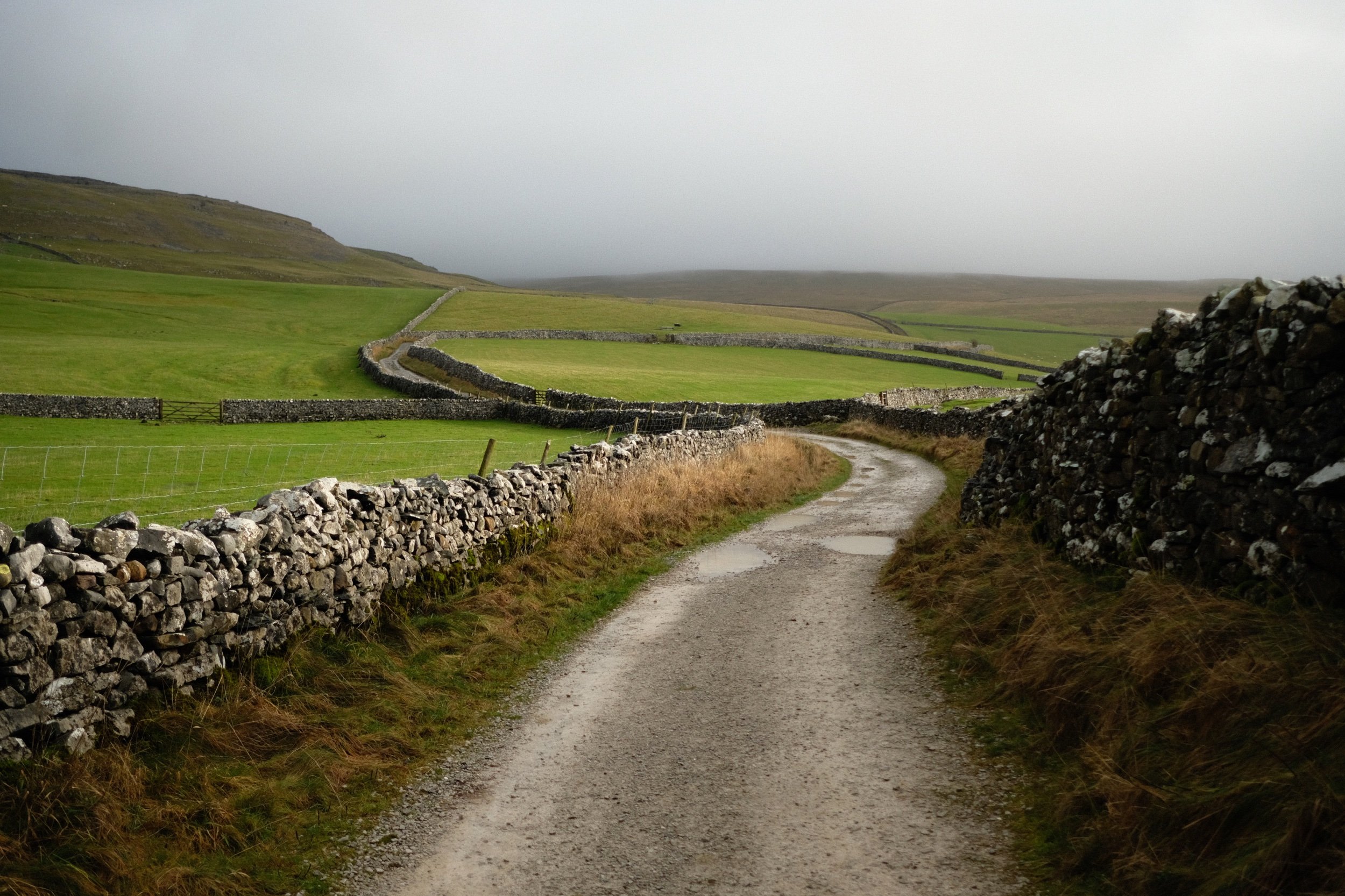
Lawson Park has no large-scale parking so we had to park at Brantwood ½ mile away and walk along the narrow East of Lake Road before taking the track up towards Lawson Park. That meant we got to enjoy lovely views of Coniston Water and the Coniston Fells in gorgeous light.
Upon locating the forestry track we climbed higher and higher towards Lawson Park. The views over Coniston Water towards the Coniston Fells, and the Old Man of Coniston (802 m / 2,632 ft) in particular, get better and better.
The light and especially the atmospheric clarity were astonishing. I almost felt I could reach across the lake and touch the fells.
Active coppicing around Lawson Park is still very much evident.
The ferns are beginning to turn colour into their autumnal rust.
Inside Lawson Park house. They’ve done a magnificent job bringing up the building to spec.
Not a bad place to spend a dark evening in.
Above the living room is a study room with books galore. Visitors were free to peruse through what they liked.
Of course, the house enjoys magnificent views towards the Coniston fells.
The flowers around the farmhouse were teeming with pollinators.
Karen Guthrie, Residential Warden of Lawson Park. It’s her learnings and vision that have shaped the gardens and land around Lawson Park into the thriving, sustainable, and environmentally-friendly place it is now.
Her guided tour around the land of Lawson Park and her work managing it was fascinating. This included these boardwalks laid to navigate through some of the bogs, made with local larch.
Karen and the other Grizedale Arts folk were keen to onboard and involve young and precocious artistic talent for various projects around Lawson Park, such as this hut built by art students.
A conifer, Picea alcoquiana, native to Japan and very reminiscent of Japanese bonsai trees.

These hydrangea were humming with insect pollinator activity. Even Karen was surprised.
Lawson Park’s vantage point is sensational, here picturing Yew Pike above Coniston village. To the right, an arts sculpture known as The Err, reminiscent of the Bowderstone above Borrowdale.
A simple larch archway in the farmhouse gardens, which will eventually be covered in creeping vines.
Two young lads make drawings of the view before them.
The Kitchen Gardens complete with polytunnels. Fruit and veg grown here feeds the residents and visitors of Lawson Park and supplies ingredients to nearby Farmer’s Arms in Lowick.
The public footpath back through the woods towards Brantwood, the former home of John Ruskin.
The Yewdale fells catch some of the reappearing late afternoon light as we head back to Brantwood.
Did you like these photos?
Crina Bottom, Yorkshire Dales, Winter
Temperatures are still down but conditions are rather contentious at the moment.
Temperatures are still down but conditions are rather contentious at the moment.
That didn’t stop us from throwing caution to the bitterly cold wind! After examining my 90 million weather apps plus satellite radars, it looked to me that the further east we went, the better our chances for drier conditions.
To the Yorkshire Dales!
We settled on a hike up to Crina Bottom from Ingleton. We did plan on an additional hike from Horton-in-Ribblesdale to Hull Pot, but we unfortunately ran out of time. Nevertheless, Crina Bottom is lovely. It’s famed for its wonderful view of Ingleborough right above the farmstead (a shot of which you can see here). Unfortunately for us on this day, the cloud base level wasn’t due to lift anywhere above 500–600m, and Ingleborough is 726 m high.
Nevertheless, the low winter light was beautiful, casting isolated golden light across the landscape, drawing long shadows, and the low cloud level made for more minimalist landscape compositions.
All photos shot on my Fujifilm X-T2 using my Fujinon 23mm f/2.0 prime lens. Images were made 95% in-camera, with a final curve adjustment in Pixelmator Photo and framing in Darkroom.
We found a spare lay-by off the Ingleton–Hawes road, and already the light was looking gorgeous.
There’s a sparseness to a winter landscape that’s dramatic and beautiful.
It’s only 2.5 miles from the start of this track, known as Fell Lane, to the mountain that is Ingleborough. As such, it’s rather steep in places.
Beautiful golden light greets us as we enter the high-walled portion of Fell Lane.
Across the valley, Twistleton Scar gets drenched in light. Chunks of the drystone wall are still collapsed after Storm Arwen.
Around this part of the track you’d normally expect to see the shoulders of Ingleborough. Not today.
Looking across the fields to the winding walls that guide Fell Lane.
Over the fields towards the Aire Gap and beyond to the Forest of Bowland, the clouds race across the sky and the sun punches through where it can.
Crina Bottom, a remote farmstead that was fairly recently on sale. I think it’s been purchased now. No doubt it will see lots of hikers who use this bridleway to ascend Ingleborough.
Just imagine a giant flat-topped mountain framed in between those trees…
The last time we hiked up to Crina Bottom was August 2017, when I was shooting with my Sigma dp0. Definitely a different world in the winter.
We decided there wasn’t really any point attempting an impromptu hike up to Ingleborough, given that it was completely engulfed in clouds, so we made our merry way back down Fell Lane.
Random bit of fleece, probably from a Swaledale sheep, snagged in the barbed wire.
The long lonnin (lane) back down to Ingleton.
The shadow of Twistleton Scar makes an appearance as storm approaches us from across the Forest of Bowland.
Beautiful Ingleton lay before us near the bottom of Fell Lane. Hmm… a flapjack sounds good about now…
We decided on a wee extra wander into Ingleton town proper to procure a few groceries from the Co-op before hiking back up to the Ingleton–Hawes Road. Ingleton is in a wonderful setting.
Deepdale, Lake District, Autumn
Grisdale keeps evading us.
Grisedale keeps evading us.
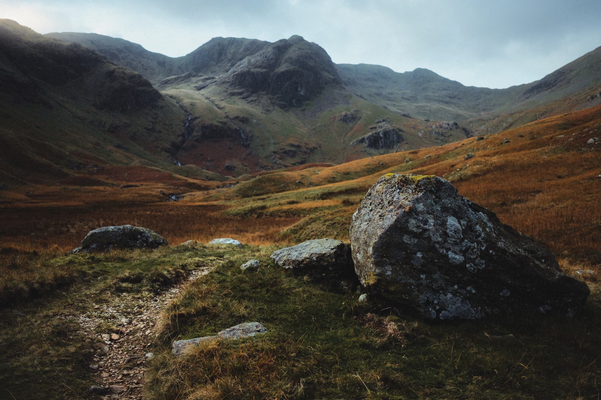
After meticulously scanning the weather forecasts and satellite radars, Dad and I embarked initially on a lovely hike up one of my favourite valleys: Grisedale.
Last time rain fended us off. This time, a running/trials event blocked all the car parks in Patterdale and Glenridding. No matter, that’s why you should have a back up plan! Instead, we drove back towards Brothers Water and pulled up in a little-used layby. This was the start of the hike into Deepdale.
Although no less splendorous compared to Grisedale—featuring as it does the magnificent fell of Greenhow End at its head—it’s certainly not as good to walk. Large patches of Deepdale are often submerged in water and super boggy to boot. This means lots of bog-hopping.
Nevertheless, a crisp yet blowy autumnal day greeted us and Dad and I were treated to delicious light and wonderful colours.
All photos taken on my Fujifilm X-T2 using my three prime lenses: a Fujinon 23mm f/2.0, a Laowa 9mm f/2.8, and an adapted Pentax SMC 55mm f/2.0. Developed in Lightroom using my own Classic Chrome-based preset, finished in Affinity Photo.
An autumnal Arnison Crag (433 m/1,421 ft) above Greenbank Farm. And some actual blue skies!
Closer to the farm, my beloved Herdwick sheep come into view and the sun illuminates the scene.
Passing through the farm, we followed the track towards the valley. As the wind was blowing a hooley, the clouds above passed intermittently across the sun, allowing beautiful spotlighting of light.
As we pass Deepdale Hall, Latterhaw Crag below and the back of St. Sunday Crag (841 m/2,759 ft) come into view, drenched in golden autumnal light.
It’s always important to remember: don’t forget to look behind you. Otherwise I would’ve missed this lovely composition.
Aureate light highlights the boulders that line the cascades of Coldcove Gill.
Rowan berries provide a nice colour contrast against the icy cold waters of Coldcove Gill.
Behind us, the tops of Angletarn Pikes (567 m/1,860 ft) and Place Fell (657 m/2,156 ft) are treated to similarly gorgeous light.
Finally, the crown jewel of Deepdale comes into view: Greenhow End. A magnificent fist of a fell, here being treated to some delicious side lighting.
A clump of boulders blocking the trail provided a lovely scene with Greenhow End in the distance.
We’ve reached that stage of autumn all the bracken and fern turns a beautiful rusty shade.
My Dad, doing what he does best: awkwardly posing (love ya, really).

At various points, the “trail” gets close enough to Deepdale Beck, allowing for compositions such as this.
Dad and I spotted this boulder, and immediately made out the face-like structure in its forms. So, I lined up this composition involving Angletarn Pikes.
Dad, enjoying the light play above us.
I spotted a cluster of boulders and glacial erratics, so I whipped out my ultra-wide lens to nab some more unusual and striking compositions.
I got real close to the glacial erratic, noting its wonderful lines, textures, and colours. I elected for a near-far ultra-wide composition, showcasing the strata in the boulder and Greenhow End above.
One of my favourite compositions from the whole hike. Just a perfect balance of light, contour, simplicity, and colour.
The head of Deepdale gets considerably boggier and impassable. That’s the point I usually turn back. Thankfully the views on the way back are no less splendid.
Place Fell providing the ultimate subject as the farm track makes a lovely leading line.
Sunlight bathes this field in warm light, leaving the fell in relative darkness. A circumstance of light and lines that I couldn’t ignore.
The farm track back to the main road. Almost impossibly idyllic.
Hunger was setting in. Time to grab some lunch.
After he was quite done grimacing at my camera, I managed to snap a nice warm candid photo of me Dad.
A lovely lunch was had at one of the Lake District’s most famous pubs: the Kirkstone Pass Inn, which has been in operation at the top of Kirkstone Pass (454 m/1,489 ft) since 1496 CE. What a lovely day out with Dad.

Pandemic Peregrinations: Helsfell Nab, Kendal, Cumbria, Winter
The Pandemic Peregrinations are back.
The Pandemic Peregrinations are back.
On the 4th of January 2021 the UK entered its 3rd National Lockdown due to rising COVID-19 cases and a new—more infectious—variant ravaging its way through the nation.
The British public are being urged to stay home at all times, save for one lot of exercise a day and essential shopping. I’m back working remotely from home again, and we’re only heading out to get some manner of exercise in, plus occasionally shopping for food.
Winter has well and truly arrived.
We decided to combine both an essential food shop with our day’s exercise today, so we hiked up Kendal Fell via Helsfell Nab, aiming towards the wonderful Plumgarths Farm Shop.
Despite the lockdown plenty of people were enjoying sledging in the somewhat slushy and frozen snow slopes of Kendal Fell. We carefully dodged the kids and adults alike whizzing passed us in their sleds, and continued on an occasionally perilously slippy walk to Plumgarths and back.
Lots of sheep about, too.
In other news—as of Saturday 9th January 2021—3,017,409 people in the UK tested positive with the virus, with 82,624 recorded deaths.
Stay safe and warm, everyone.
All photos shot with a Fujifilm X-T2 using my Samyang 35mm f/1.2 lens. Developed using RNI’s Kodachrome film profile.
Fresh snow everywhere.
Winter has well and truly arrived.
We made friends with this gorgeous girl, who was exploring the winter landscape.
We really had to watch our footing on most of the walk. Most of the snow had either frozen over or was heavily compacted, making it all rather slippery.
A wintery Kendal town.
There were plenty of sheep around the lower slopes of Kendal Fell. Not sure of the breeds, probably a lot of North England Mules.
You’re never far from the countryside in Kendal.
I love the quizzical expressions sheep give you.
Managed to snap this young lass as she sped down the slopes of Kendal Fell.
Our way forward.
It was nice to see families out enjoying the “snow”.
My lovely Lisabet keeping up, despite slippery conditions.
Navigating through the woodland below Helsfell Nab.
As we gain height the views open up and the cloud shelf lowers.
We skirt around the lower slopes of Cunswick Fell to head towards Plumgarths Farm Shop. A beautiful Cumbrian winter scene.
The lonely track towards High Helsfell Farm.
Our destination for the day: Plumgarths Farm Shop. It’s a small place, so Lisabet went in to get supplies and I stayed out.

Deepdale, Lake District, Winter
Winter has arrived.
Winter has arrived.
We’ve been watching as temperatures in Cumbria have steadily dropped from the tens to near freezing point.
By around the 3rd December snow started to fall across the high fells of the Lake District and the Yorkshire Dales, followed by some ground level snow on the 4th.
Lisabet and I ventured straight into the Lakes on the Saturday to see if we could get some snowy mountain action whilst the snow was still around.
A lot of it had melted in the dale bottoms, resulting in some delightful cascades and waterfalls, but we were happy to see a fair bit of snow still clinging to the higher peaks of the Lake District.
We hiked into Deepdale, a small tributary valley off Patterdale, just north of Kirkstone Pass. The nice thing about Deepdale is you’ll rarely find a lot of people there. The not-so-nice thing is that the hiking can be laborious, as there’s not much of a path through the valley and there’s a fair bit of bog to navigate.
But what awaits you at the head of Deepdale is the magnificent hulking form of Greenhow End, a beautiful fell.
All photos taken on my Fujifilm X-T2 using both my Samyang 35mm f/1.2 and Laowa 9mm f/2.8 lenses. Photos shot using a customised Pro Negative Standard film profile.
Booting up. Love that anticipation and excitement when you’re getting ready for a hike, thinking about what scenes and light awaits you.
There were plenty of Herdwicks around the valley bottoms, fattening up for the winter. Probably all now pregnant, too.
Deepdale is quite a desolate and featureless valley, save for the wonderful crags at its head. There are a few glacial erratics lying about, though, that you can play with compositionally. I found this large boulder with a clear crack running through it, which I used in this focus-stacked photo to point towards Greenhow End.
Another group of rocks and boulders housed this little pool that I framed in another composition towards Greenhow End. A single frame shot at f/22 with my ultra-wide 9mm Laowa lens.
A tighter composition of the magnificent Greenhow End, with some gorgeous late-afternoon winter sun light.
I found another large boulder with some interesting moss, lichen, and trackline markings.
Another boulder I found had this very interesting crack running right through that, from certain angles, sort of reminded me of PacMan…
Heading back out of the valley I found more interesting arrangements of boulders to utilise compositionally, also positioning Deepdale Beck as a leading line towards Angletarn Pikes.
A tighter 35mm composition of Angletarn Pikes allows me to also features some of the old barns and farm houses of Wall End.
My lovely Lisabet, capturing a composition of one of her favourite stone bridges.
Herdwicks have such characterful faces.

Part 2: Lancaster Canal’s “Northern Reaches”, Cumbria, Spring
The final stretch of Lancaster Canal.
The final stretch of Lancaster Canal.
In case you haven’t seen it you should check out my first photo blog about the Lancaster Canal, which contains the history of this iconic and important canal system.
The following day Lisabet and I decided to revisit the canal’s “Northern Reaches”, this time heading north from Millness Bridge (Nº 164) in Crooklands instead of south. This stretch is the final waterway of Lancaster Canal, which ends at Stainton somewhat abruptly. There are ambitions to re-water the canal for a quarter of a mile north of Stainton towards Kendal, and work has begun on repairing and upgrading Stainton Aqueduct after Storm Desmond wreaked havoc in December 2015.
All photos shot on a Fujifilm X-T2 with a 16–50mm f/3.5–5.6 lens using a customised Classic Chrome film simulation.
Looking back on Crooklands Bridge (Nº 166), which carries the B6385 over it. Another scorching hot day with barely any wind means very low water levels in the canal and pristine reflections.
Bulls and bullocks paddle in the waters of Lancaster Canal to cool down and have a sip.
Honestly, I were tempted to join them.
I kept waiting for this bull to look at me for this photo but it adamantly refused.
Not sure it’s possible to get a more bucolic scene of English rural idyll.
Old Hall Bridge (Nº 167) with almost perfect reflections; beyond you can just make out the slopes of Scout Hill (284 m/931 ft). On the banks before this bridge Lisabet and I were enthralled by a grey heron (Ardea cinerea), fishing in the waters of Lancaster Canal.
The end of Lancaster Canal at Stainton.
The next stretch of Lancaster Canal from Stainton, which has been relaid with lining and blocks. Not quite filled up yet, and of course it currently remains unconnected.
After Sellet Hall Bridge (Nº 173) the newly restored Lancaster Canal ends once again, totally dried up and reclaimed by nature.
Nature closing in on the 200-year old structures of Lancaster Canal.