
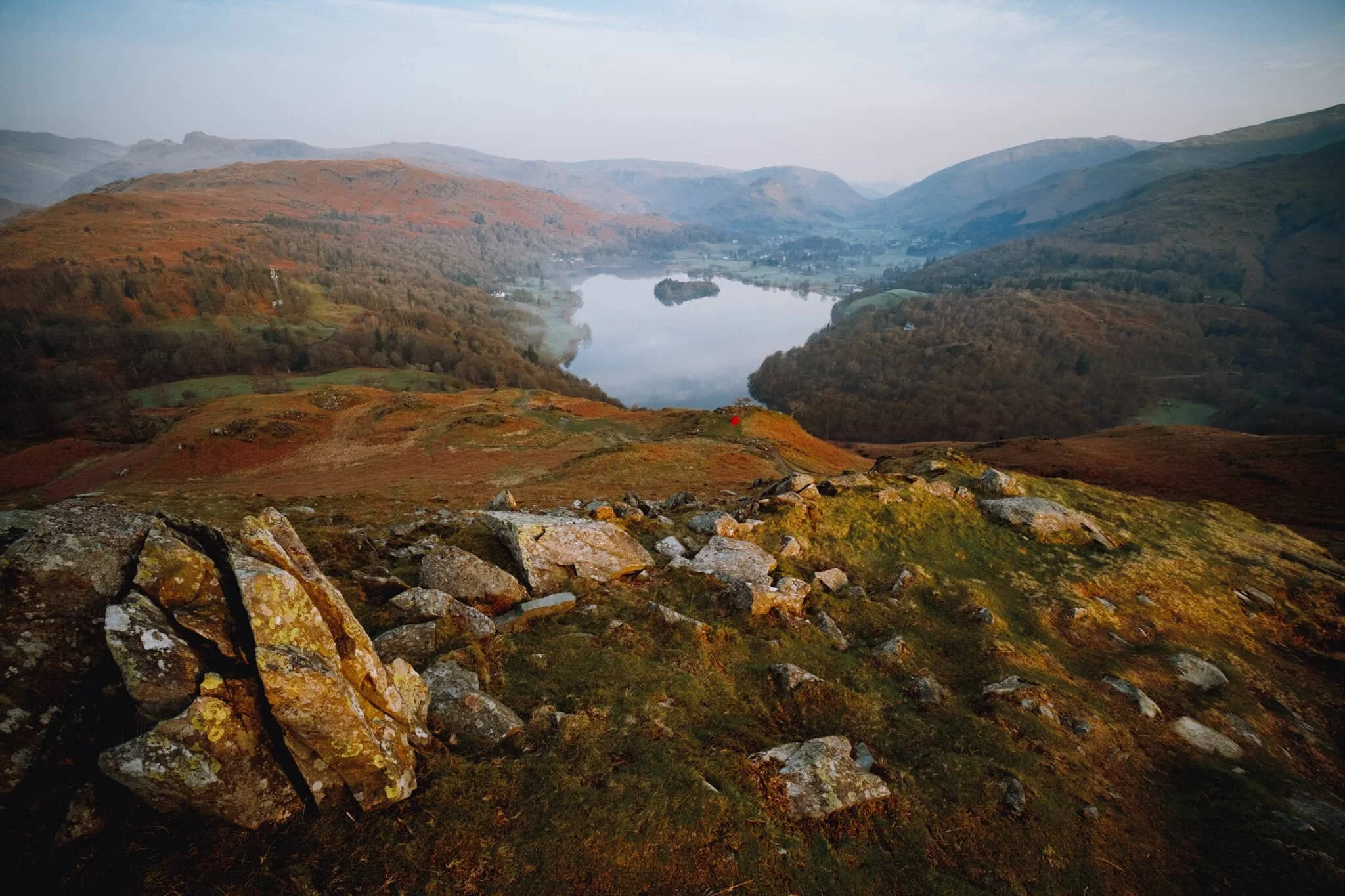
Grasmere, Lake District, Winter
The winter lurgy has struck.
The winter lurgy has struck.
Following a lovely hike around Ambleside, Lisabet came down with a rather nasty cold and I followed suit soon after.
We’re both at the tail end of this bug now, but with depleted energy levels as can be expected. A crisp, clear, and super cold Sunday greeted us, so we set off towards the impossibly bonny village of Grasmere for a wee waltz around the area.
All photos shot on my Sony α7ii using my Pentax SMC 28mm F3.5 and Pentax SMC 55mm f2.0 prime lenses. RAWs developed in Lightroom and edited in Photoshop.
Grasmere, Lake District, Winter by Ian Cylkowski is licensed under CC BY-NC-SA 4.0![]()
![]()
![]()
![]()
The trail in the direction of Allan Bank enjoys wonderful views towards Helm Crag and Seat Sandal. Here, the latter of the two fells is stroked by golden afternoon light across its flanks.
Across the vale, the craggier yet smaller Helm Crag receives similar treatment from the emerging winter sun.
Heading down the hill towards Goody Bridge, the snowcapped Great Rigg on the right is illuminated. Love the rusty colours some of the Lake District and Scottish fells turn in the autumn and winter.
Expansive views from the Allan Bank trail lead to Seat Sandal being bathed in afternoon winter sun.
A timeless route back to the village centre. There’s no need to hurry.
Did you enjoy these photos?
Grasmere Sports & Show, Lake District, Summer
Back for the first time in 2 years.
Back for the first time in 2 years.
Time for something rather different from me.
If you’re a long-time follower of my blog or work (hello, and thank you!) you’ll know I’m mostly about the landscapes, nature, architecture, and travel.
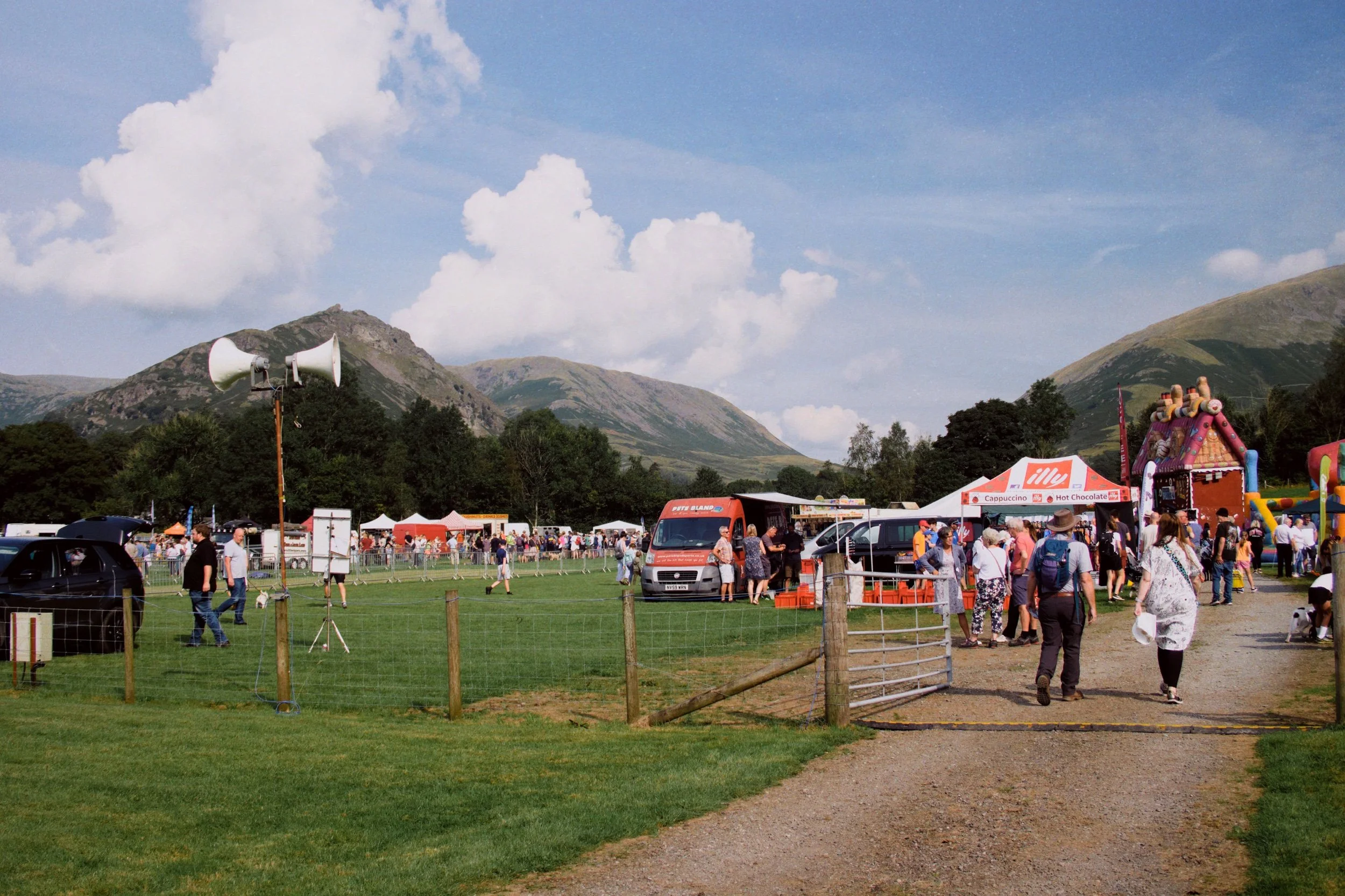
This weekend, however, we were given the opportunity to attend the Grasmere Sports & Show event. Lisabet’s work place sponsored the event and had free tickets going, which we gladly took. We also met up with me Dad there and made a day of it.
The Annual Grasmere Lakeland Sports event has been a regular annual affair since 1868, unbroken save for the two World Wars and, more recently, the COVID-19 global pandemic.
It hosts traditional Cumberland Wrestling, for a variety of age brackets, fell running, hound trailing, and loads more. A true celebration of traditional Lake District sports.
In addition, there are dog shows—for pros and amateurs alike—bands, a beer tent, and loads of stalls hosting street food, artisans, and charitable organisations.
It was a beautiful summer’s day, and everyone seemed happy to be back at one of the Lake District’s most eagerly anticipated calendar events.
All photos were shot on my Fujifilm X-T2 using my Vivitar “Series 1” 28–105mm f2.8–3.8 zoom lens. RAW files converted in Capture One for iPad then developed in RNI Films.
Grasmere Sports & Show, Lake District, Summer by Ian Cylkowski is licensed under CC BY-NC-SA 4.0![]()
![]()
![]()
![]()
A grand summer’s day was afoot for the event.
Fat Cat Brass kicked off the show with a variety of tunes, old and new.
The show’s setting in Grasmere is spectacular, especially on a glorious summer’s day.
Falconry & Cumberland Wrestling
The Ridgeside Falconry display was excellent. Kids were challenged to come onto the field and make a tunnel with their arms.
A hawk or eagle, can’t remember which, would then fly through the tunnel to nab some food.
A Turkey Vulture (Cathartes aura), incredible creature.
Next up was the Under 10s Cumberland Wrestling.
The lass in the proper wrestling costume was so good. She’d go on to win Silver.
The starting backhold position involves the wrestlers standing chest to chest, grasping each other around the body with their chins on their opponent's right shoulder. The right arm of each contestant is positioned under his opponent's left arm.
Once the grip is taken the umpire gives the signal to start the contest by calling "en guard", then "wrestle".
The wrestlers attempt to unbalance their opponent, or make them lose their hold. If any part of a wrestler's body touches the ground aside from their feet then they lose.
Manoeuvres include lifting throws known as "hipes", twisting throws such as "buttocks" and trips like the inside click, cross click, back heel or outside stroke.
If both wrestlers fall down at once the last to hit the ground is deemed the winner. If it’s unclear who hit the ground first the fall is disqualified and must be started again. This is known as a "dog fall".
A win can also be achieved if either wrestler loses their grip on the other while the opponent still retains their hold.
Another lass in the wrestling costume. She had a true fighter’s spirit, so determined.
Smaller than most she faced, but more than made up for it with technique and determination.
Limbs flying akimbo.

Mohawk lad put up a good fight, but he was facing the ultimate winner of the tournament.
Quite proud of nabbing this shot.
These kids will only get better and better.
From the same wrestling club, now facing each other in the ring.
A semi-final bout.
There were a few hard falls taken by various wrestlers. All handled it well.
The bout for 3rd and 4th place. Little lass takes a fall on her bonce.
Nevertheless, she gets back up…
…and wins Bronze with this fall.
The bout for gold and silver. Two at the top of their game.
Ultimately, the young lad takes Gold after a hard-fought bout.
The winner.
The podium for the Under 10s.
We stayed for a few more bouts in the Up To 12s category.

Quite a few hang gliders were enjoying the sights above Grasmere.
The Dog Show
The Dog Show! Starting with the pups. Warning: adorable dogs ahead.
One of my favourite shots of the day.
Plenty to entertain the kids and the young-at-heart alike.
We rested up on a bank for a spot of lunch, taking in the atmosphere of the event.
Classic cars on show. Me Dad will be able to tell you what these are.
It was good to do something different.
Did you like these photos?
Easedale, Lake District, Autumn
And just like that, it starts to feel like winter.
And just like that, it starts to feel like winter.
This past weekend, temperatures suddenly plunged 5–8°C, bringing in clear and frosty days with freezing cold nights. On the Sunday, a crystal clear blue-sky day greeted us, so we donned our gloves and hats and made our way into the Lake District. Our goal: a lovely autumnal hike from Grasmere, up to Easedale Tarn via Sourmilk Ghyll, and back down into Far Easedale before returning to Grasmere.
A good 10km hike with some solid ascension.
The last of the autumn colours were evident in the rust-coloured bracken and the leaves littering the footpaths. Just one of those days where it feels great to be outside and alive.
All photos taken on my Fujifilm X-T2 using two of my prime lenses: my Fujinon 23mm f/2.0, and an adapted Pentax SMC 55mm f/2.0. Images lightly developed in Lightroom from Classic Chrome RAW files, finished in Affinity Photo.
It doesn’t take long before a clear view of Helm Crag (405 m/1,329 ft) comes into view.
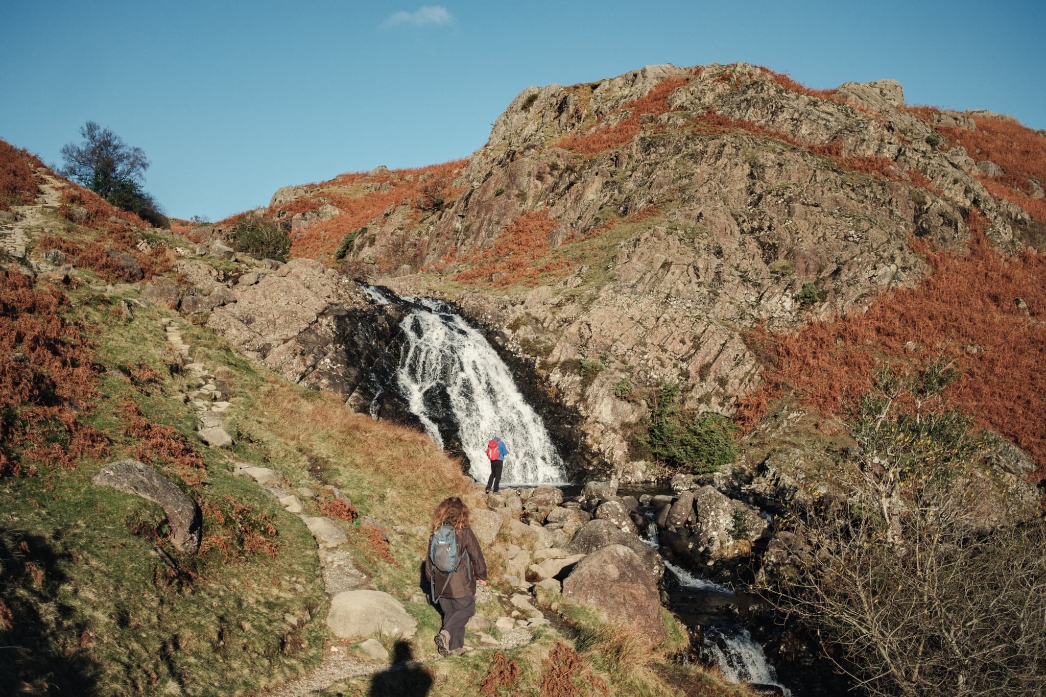
The trail takes us into Easedale where the arresting sight of Sourmilk Ghyll towered by Tarn Crag (551 m/1,808 ft) and High Raise (762 m/2,500 ft) comes into view.
To our right are the slopes of Helm Crag. Though not a tall fell by Lake District standards, it is deceptively steep.
Across the beck, chunky Herdwick tups graze in the fields below Helm Crag.
Further along the trail, another field beneath Helm Crag was home to some Herdwick lambs with their darker fleeces.
The first goal of the day: Sourmilk Ghyll, with Ecton Crag rising protectively above it.
The waterfalls are an impressive sight. Sourmilk Ghyll was probably named for its bright white water contrasted against the dark ravine it tumbles down.
Above and beyond the falls, the footpath climbs to Easedale Tarn with the imposing face of Tarn Crag directly above it.
Tarn Crag and Slapestone Edge plunge directly into the deep, dark, and cold waters of Easedale Tarn. Fancy a swim?
The view looking back the way we came is no less impressive, taking in Helm Crag, Heron Pike (612 m/2,008 ft), Great Rigg (766 m/2,513 ft), and Fairfield (873 m/2,864 ft).
Adventurous hikers have the option of taking the path all the way around Easedale Tarn and up towards Codale Tarn on the way to High Raise. For us, we crossed the beck flowing out of Easedale Tarn and followed the less-travelled path towards Far Easedale.
One or two clouds joined us on our hike, casting their shadows across Cockly Crag and Greathead Crag.
Look back at the loosely pitched footpath we took from Easedale Tarn.
As the path started to descend down into Far Easedale, more clouds darkened the fellside of Gibson Knott.
My lovely Lisabet leading the way, with the sun drowning the fells in warm light.
Our destination is the valley bottom of Far Easedale, directly underneath Gibson Knott and Horn Crag, at Stythwaite Steps.
To the east, a more slender profile of Helm Crag can be seen. We could not have asked for better light conditions on this day.
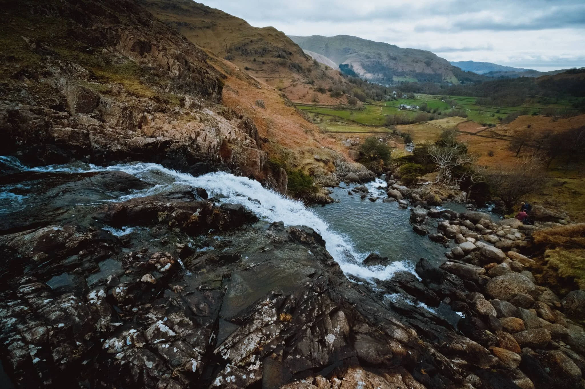
The valley bottom at Far Easedale, following the line of Far Easedale Gill towards Pike of Carrs. Time for lunch!
Post-lunch, we followed the craggy trail east back towards Grasmere. This giant boulder above us gained our interest, largely for the addition of a drystone wall perched on top of it!
The Far Easedale path back to Grasmere is definitely more rough and wild, but that just made for more interesting scenes.
Gradually, the path increases in quality as it navigates around giant boulders and ancient barns.
A true Lake District scene: Herdwick sheep and the fells.
This lovely lady had no issues at all posing for us as we snapped away.
Looking back, beyond the ancient Brimmer Head Farm to the waterfall and Easedale fells.
Nearing Grasmere, views of Heron Pike and Rydal Fell soon come into view. Gotta love this time of year for the low angles of light.
Across Broadgate Meadows, the peak of Seat Sandal is darkened by the clouds above. Back to the car park we go.
Easedale, Lake District, Spring
It’s been quite a few years since we’ve been to Easedale.
It’s been quite a few years since we’ve been to Easedale.
In fact, looking through my archives, it’s been four years and a month. Today, Lisabet and I decided we were due for a revisit.
Easedale is a small valley to the northwest of Grasmere village. There are one or two country houses, plus a couple of farms, but arguably its main feature is the waterfall at its head: Sourmilk Gill. This waterfall drops 70-metres as several cascades in between the two towers of Brinhow Crag and Elton Crag. From a distance, with the brilliant white water set against the dark rocks, it’s easy to see why the waterfall has been named such.
Beyond Sourmilk Gill one can extend the walk further to the source of the gill, Easdale Tarn, a picturesque mountain lake dominated by the looming face of Tarn Crag.
We took the standard “tourist” route through Easedale and up alongside Sourmilk Gill towards Easedale Tarn. After a snack, we crossed the gill and followed the boggy path to Stythwaite Steps, the entrance to the floor of the Far Easdale valley. I’d personally never been here before and was delighted by the sights. It’s hard to ignore the bold face of Horn Crag rising above the valley. We then followed the track southwest, rejoining Easedale and back into Grasmere.
All in all a beautiful walk, helped with another lovely day of weather.
All photos shot on my Fujifilm X-T2 using my three prime lenses: a Samyang 35mm f/1.2, a Laowa 9mm f/2.8, and an adapted Pentax SMC 55mm f/2.0. All developed using RNI’s Kodachrome film profiles.
Picturesque Grasmere village. I never tire of the scene looking down Broadgate towards Heron Pike (612 m/2,008 ft).
Only in the countryside…
You bet we bought some of Maisie’s flapjacks. Delicious they were, too. Thank you, Maisie!
As we climb up the path towards Sourmilk Gill, the views over to the Fairfield fells reveal themselves.
The milky-white waters of Sourmilk Gill, with Elton Crag looming above like a giant knuckly first punching defiantly into the sky.
Getting as close to the plunge pool as I dare, with my lovely Lisabet above.
One of my favourite scenes around Grasmere, following the milky-white waters as they tumble down towards Easedale.
Beyond the falls we followed the path up to Easdale Tarn. And though the tarn is pretty, the views back towards Helm Crag and the Fairfield fells is equally wonderful.
The upper section of Sourmilk Gill as it gently meanders to where it will ultimately tumble down to Easedale.
Easedale Tarn, with Tarn Crag’s (551 m/1,808 ft) rounded face high above.
A rather beautiful wind-swept tree leaning away from the waters of Easdale Tarn and Tarn Crag above.
After writing off venturing further towards another tarn above, known as Coledale Tarn, we head back towards the outflow of Easedale Tarn and cross the gill.
One last look back at the bulky head of Tarn Crag.
After carefully navigating the boggy path on the northern side of Sourmilk Gill, we follow the steps down to Far Easedale, known as Stythwaite Steps.
At the floor of the Far Easedale valley, I located a couple of massive boulders I found interesting. I lined up some compositions involving their wonderful colours, textures, and patterns.
Far Easedale. A beautiful valley, with Horn Crag demanding your attention.
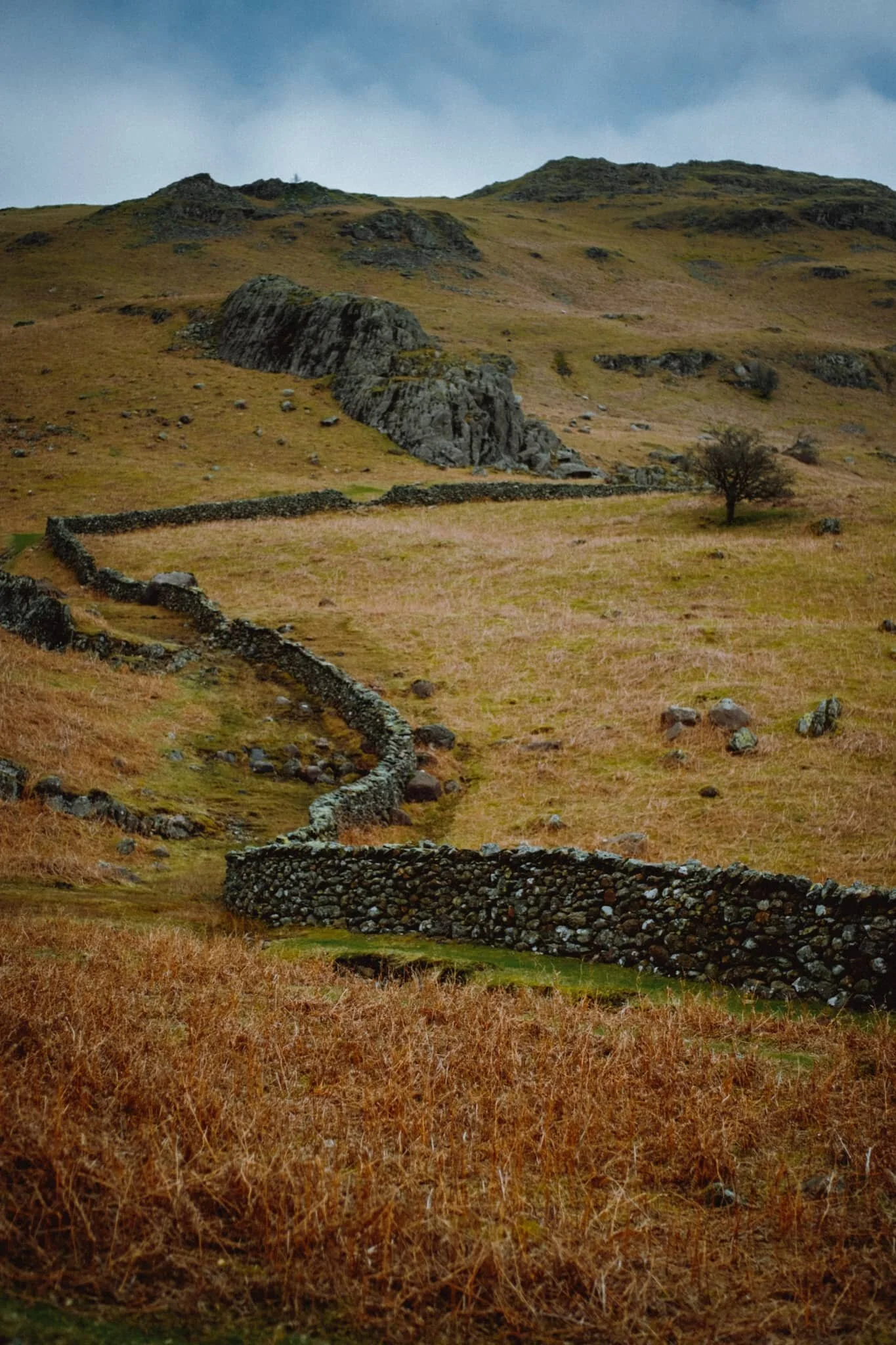
“Ian, look! A winding drystone wall.” Lisabet knows me too well.
Brimmer Head Farm. This is referenced on the OS Map in an old-style Blackletter typeface, indicating historical interest. Turns out that there’s a building in the farm that dates back to 1574, reputedly the oldest house in Grasmere.
Another look back at Sourmilk Gill as the path out of Far Easedale rejoins Easedale near the Lancrigg Hotel.
Lisabet taking in the sights before we head down the lane.
Towards the end of our hike the cloud base had lifted off the higher fells above Grasmere, revealing their comely shapes.
Heron Pike above the village, catching some rays. Sheep peacefully graze in the common alongside Broadgate. A day that makes you feel truly grateful.
Loughrigg Fell, Lake District, Spring
Step 1 of the UK Government’s Spring 2021 COVID-19 plan has been completed.
Step 1 of the UK Government’s Spring 2021 COVID-19 plan has been completed.
From Monday 29th, more people can now meet outside, outdoor recreation activities are permitted again, and the “Stay at home” ruling has relaxed to “Stay local”.
I’ve taken some time off work before and after the Easter weekend in order to recuperate. I’ve been feeling burned out for quite a while now. So what did we do on our first full day off?
We woke up at 5am for a sunrise hike up Loughrigg Fell (335 m/1,099 ft).
We’ve only ever been up Loughrigg once before, again for sunrise, back at the tail end of summer 2020. The fell really isn’t that tall in Lake District terms, but it covers a decently large area, which opens up a wide variety of views to shoot.
On this hike, we were greeted with the remnants of a temperature inversion clinging to the waters of Grasmere as well some of the valley bottoms. We only saw three other people around the fell; in fact, there were more sheep! Couldn’t have asked for better conditions.
All photos taken on my Fujifilm X-T2 using my three lenses: a Samyang 35mm f/1.2, a Laowa 9mm f/2.8, and an adapted Pentax SMC 55mm f/2.0. Photos developed using RNI’s Kodachrome film profiles.
The calm waters of Grasmere, reflecting Helm Crag (405 m/1,329 ft) and Seat Sandal (736 m/2,415 ft). The remnants of a temperature inversion lent a beautiful misty atmosphere.
We wound our way up through Deerbolts Wood to find the main footpath up Loughrigg Fell.
As we began ascending the main footpath up Loughrigg Fell the views quickly opened up. From Loughrigg Terrace the temperature inversion was more visible, and I couldn’t resist this composition of the mist clinging to the valley, with Nab Scar (455 m/1,493 ft) looming above.
Although the sun had risen, from our location it was still trapped behind a low bank of cloud. By this point of the hike up Loughrigg, the sun was beginning to peek above the clouds, its light glowing through this solitary tree resolutely rooted to the fellside.
More sunrise light as the sun rose above the cloud base. We passed this occupied tent on our way up. A nice spot, for sure, but technically they’re not allowed to wild camp.
Beautiful Wetherlam (763 m/2,502 ft) finally receiving some of the sunrise light, as the mist in the valleys starts to burn off.
Nearly at the summit of Loughrigg, we look back to this cracking view of Grasmere, its namesake village, and the Central Fells.
The summit of Loughrigg Fell. With the sun clearly above the clouds, beautiful golden light drenched across the rolling folds of the fell.
A Herdwick ewe, enjoying the morning light. Not a bad view to chill out whilst chewing the cud, eh?
Another Herdwick ewe, lower down the slope. It’s a sheep’s life in the Lake District.
This Herdwick ewe, closer to us, was much more vocal. Probably warning the others about our presence.
The summit of Loughrigg is wonderfully craggy. My ultra-wide 9mm lens was able to fill the frame with this crag and also take in the extensive view towards Windermere.
We carefully picked our way back down the wet northern slopes of Loughrigg, stopping for the occasional photo along the way. This area of the fell was extensively mined for slate in the Victorian era, now long abandoned. Its remnants make for interesting compositions towards Nab Scar and Rydal Water.
This is Rydal Cave, formerly Loughrigg Quarry, and completely man-made. You can often find ducks and fish milling about in the shallow pools of the cave.
It’s not often one gets Rydal Cave all to oneself, so we ventured in for some photos.
Now back onto Loughrigg Terrace, the going is much easier as we saunter gently back towards the car through White Moss Woods. This particular aspect of Loughrigg Fell is called Ewe Crag.
An old barn, long fallen into disrepair and nature quickly reclaiming it.
Into White Moss Woods with gorgeous golden morning light streaming in.
Still a fair bit of colour in the woods. Soon, White Moss Woods will be absolutely full of bluebells. Give it a month or so.

Loughrigg, Lake District, Autumn
There are several Wainwrights that are considered key or “core” Wainwrights.
There are several Wainwrights—that is, Lake District peaks written about in Alfred Wainwright's seven-volume Pictorial Guide to the Lakeland Fells—that are considered key or “core” Wainwrights.
They include the likes of Catbells, Helvellyn, Scafell Pike, and the Old Man of Coniston.
You could also argue that Loughrigg Fell should be included as a core Wainwright, too. And in all my years of living in Cumbria I’ve never once been up this relatively small yet sprawling fell.
So, at 5:00am this morning, we changed that.
Loughrigg Fell, or just Loughrigg, is one of the smaller Lake District fells, measuring only 335 m or 1,099 ft (compare this to England’s highest peak, Scafell Pike, coming in at 978 m/3,209 ft). However, its mass covers a surprisingly large area near Central Lakeland. To its north are two lakes: Grasmere and Rydal Water. To its west the fell overlooks Loughrigg Tarn followed by Elter Water. East, the River Rothay runs through a shallow depression, and south of Loughrigg is England’s largest lake: Windermere.
Because the fell covers such a large area there are many ways to access its numerous crags and the summit. We arrived at a lay-by near the shore of Grasmere and set off for the fell at around 6:45am. We took the route through Penny Wood onto Grasmere “beach” and then up into Deerbolts Wood, before joining Red Bank and taking the steep pitched path up onto Loughrigg’s various nobbly crags.
The morning was clear and glorious, and we watched as the rising sun slowly lit up the various peaks you can make out from around the shoulders of Loughrigg, such as Wetherlam and the Langdale Pikes. By the time we hit the summit the sun had risen and was covering the rolling crags of Loughrigg in golden light.
What a cracking morning.
All photos shot on a Fujifilm X-T2 with a XF 18–55mm f/2.8–4.0 lens using a customised Classic Chrome film profile.
Looking back down the steep pitched path that was our route up to the summit of Loughrigg. Silver How (395 m/1,296 ft) starts catching the soft pre-sunrise light.
Loughrigg features lots of lovely crags from which you can take your pick of compositions towards the distant fells. Here I pointed the camera towards the Langdale Pikes as they started to glow.
I find another or Loughrigg’s crags, surrounded by autumnal fern, which I use to point towards Wetherlam as it glows pink.
Higher up we can better make out the Langdale Pikes and Crinkle Crags (859 m/2,818 ft) as more of the land is bathed in warm sunrise light.
Another crag offers a framing and leading device for a composition towards Dunmail Raise, north of Grasmere village.
My lovely Lisabet takes a pew on some crag and enjoys the views as more of the fells light up in the sunrise glow.
A beautiful Herdwick yow (ewe) stares at us curiously with its smiling face. Behind her are the glowing slopes of Lingmoor Fell (469 m/1,539 ft).
The Rydal Fells, which ultimately lead up to Fairfield (873 m/2,864 ft).
Looking up the undulating folds towards the summit of Loughrigg, marked by a trigpoint.
I wanted to capture the criss-crossing and layering of the land as the sun rose over the fells.
Looking back at the route up to the summit of Loughrigg. In the distance is Grasmere village and the fells north of it: Helm Crag, Steel Fell, and Seat Sandal.
From the summit of Loughrigg you can finally make out some of Windermere lake.
From the summit you can enjoy a clear view of Wetherlam (763 m/2,502 ft), which I shot from the summit’s crags.
Probably my favourite photo from the whole hike.
Another ewe enjoys the views from one of Loughrigg’s crags.
The rolling craggy landscape of Loughrigg as the walking trails meander towards Windermere.
Lisabet inches closer for a better snap of the ewe and her lamb.
Incredible views from Loughrigg towards Elter Water and Wetherlam above.
Up in the Lakeland Fells autumn has arrived as the fern on the fell slopes turn a beautiful rusty colour.
A lone Herdwick ewe munches on the bracken in a steep gully below the rolling crags of Loughrigg.
Near Loughrigg’s northeastern slopes you can find increasing evidence of quarrying. Here we found a deposit of slate, forming a little mound of its own.
Tracking the outcrops of rhyolite and basaltic andesite towards the Scandale fells.
Lisabet pauses to enjoy the views as we navigate our way down the slopes of Loughrigg.
Back onto the main path that circumnavigates Loughrigg, known as the Loughrigg Terraces, we find Rydal Cave. This is a man-made cave; created as consequence of quarrying slate for roofing material.
A pool has filled Rydal Cave, offering crisp reflections that I played around with.
We spotted teeny little fishes in the pool too! Couldn’t say what they were, though.
Back on the main path around Loughrigg and looking up at Ewe Crag.
Into the woods alongside the River Rothay we chanced upon a couple of Herons. One of them flew off almost immediately but this one, hunched up, stayed on its perch long enough for me to get this quick snap.
In Penny Wood we notice that Grasmere is offering some crisp reflections of Silver How, which clamber down to get shots of.
All in all a 10/10 morning.