
Hull Pot, Yorkshire Dales, Winter
A month since my last post.
A month since my last post.
I do apologise.
The weather in January has been, well, shocking to say the least. We endured three named storms: Henk, Isha, and Jocelyn. Isha, in particular, was one of the most powerful storms the British Isles have seen since 2000.
Additionally, we’ve had periods of below freezing temperatures, resulting in widespread ice.
It’s been… interesting.
Thankfully, the weekend just gone, it was nice enough for us to finally head out. We chose the Hull Pot route from Horton-in-Ribblesdale in the Yorkshire Dales. I had an inkling that there’d still be some snow liggin’ about in the Dales, contributing to a water-saturated landscape and, hopefully, a waterfall flowing into Hull Pot.
And we finally saw it.
All photos taken on my Sony α7ii using my Pentax SMC 28mm F3.5, Pentax SMC 55mm f2.0, and Rokinon 14mm f2.8 ED AS IF UMC prime lenses. RAWs developed in Lightroom, edited and finalised in Photoshop.
Hull Pot, Yorkshire Dales, Winter by Ian Cylkowski is licensed under CC BY-NC-SA 4.0![]()
![]()
![]()
![]()
The characteristic drystone walls of the Yorkshire Dales remained steadfast in the face of all the snow we’ve had recently, resulting in these snowdrifts piled up against them.
Our way forward. We knew on this day that there’d only be 2-3 hours of good light, and boy was it dramatic.
Looking back at where we came from. We were very much on the edge of two weather systems. Conditions over Horton-in-Ribblesdale saw blue skies and puffy clouds, but closer to Pen-y-Ghent it was blowy, dark, and stormy, giving us epic light.
A good sign: A small waterfall where there usually isn’t at Horton Scar. Above, Pen-y-Ghent fights with the dark and stormy clouds.
Further up the bridleway, the site of an extinct waterfall below Pen-y-Ghent, which is now obscured by clouds laden with snow. A burst of sun to our right picks out the details in the land.
And there she is, finally ticked off my bucket list. England’s largest natural hole, Hull Pot, with Hull Pot Beck tumbling down 60ft into the chasm. As mentioned before on this blog, Hull Pot is a large cave where the roof has collapsed, which has resulted in this massive chasm below Pen-y-Ghent. With my ultra-wide 14mm equipped, I was able to capture the entire scene.
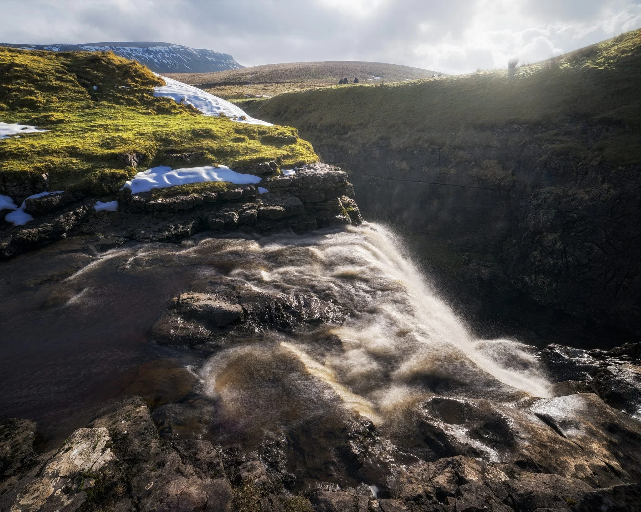
We clambered as close to the waterfall as possible as it crashed over the edge into Hull Pot. As I had no tripod, I shot this with my ultra-wide 14mm at f/22, taking multiple exposures of the same scene. In post, I then averaged the exposures together that gave me that long exposure effect on the water.
Looking up Hull Pot Beck and its many cascades. By the normal way of things, this beck is dry as it usually disappears into the maze of caves beneath Pen-y-Ghent before it reaches Hull Pot. With all the rain and snow we’ve had, the beck was able to complete its route, crashing 60ft down into Hull Pot and re-emerging at the surface nearer Horton-in-Ribblesdale.
A different view of Hull Pot from its eastern end. Two boulders balance precariously on the lip of the pot.
At around 450 m/1,476 ft above sea level, a few snow patches have lingered around the edges of Hull Pot, allowing for some interesting compositional leading lines.
A particularly clean snow patch nearer the falls gives me an idea for a composition involving Pen-y-Ghent in the distance. Fellow hikers milling about the edge of Hull Pot give you a sense of scale of this place.
Heading back down to the village, signs were clear that the best of the day’s light were done as the storm clouds rolled in. We were thankful to get what we did, though.
Did you enjoy these photos?

Ambleside, Lake District, Winter
Temperatures have plunged.
Temperatures have plunged.
The nigh persistent rain of November and December has given way to a sub-zero climate and clearer conditions. Much better.
With a bright Saturday forecast, Lisabet and I ventured into the heart of the Lake District and major tourist hotspot, Ambleside. We wanted to do two walks: one, a small circular of Stock Ghyll Force, the other bigger hike up to High Sweden Bridge.
Despite being in the middle of a blisteringly cold winter in the Lake District, Ambleside was as busy as ever. This town never gets any rest.
All photos taken on my Sony α7ii using my SMC Pentax-M 28mm F3.5 and SMC Pentax-M 55mm f2.0 prime lenses, plus my Vivitar “Series 1” 70–210mm f2.8–4.0 zoom. RAWs developed in Lightroom, edited in Photoshop.
Ambleside, Lake District, Winter by Ian Cylkowski is licensed under CC BY-NC-SA 4.0![]()
![]()
![]()
![]()
A misty shot from the top of Stock Ghyll Force. Made by stacking five landscape 28mm shots, top to bottom, for a wider field of view.
The classic view of Stock Ghyll Force, currently in its more barren winter finery.
After stopping for delicious hot brews at Force Cafe, we followed the trail back down to the town. By the side of the road, this still life-esque scene revealed itself to me, and so quickly I quickly nabbed a composition.
From the town centre, it’s easy enough to find the route to the High Sweden Bridge trail. Given the direction of the low sun, we opted instead to take the trail anti-clockwise, which we’ve never done before, to get more side light.
The old packhorse bridge itself, with my Lisabet providing a nice colour contrast as she strolls across it. As I’ve mentioned on this site elsewhere, the name “High Sweden Bridge” might seem unusual, given this is located in the Lake District, England. The “sweden” aspect originally comes from the Old Norse sviðin (pronounced “swee-thin”), the past participle of svíða, meaning “to burn” or “to singe”. In this context, it refers to the clearing of land by burning.
Looking up Scandale, admiring the light beams scanning across the face of High Pike (656 m/2,152 ft).
Heading back down the higher eastern side of the Scandale valley, I equipped my 70–210mm lens for some tight and distant compositions. Fully zoomed in, I was able to pick out the mist clearing from the summits of the Langdale Pikes, on the right, and Bowfell on the left.
My 70–210mm also has a macro mode, which I used to try and capture these beautiful and tiny Cladonia pyxidata lichen.
Lake District sheep get all the best views.
Did you enjoy these photos?
Ulverston, Cumbria, Winter
It’s been a while since my last post.
It’s been a while since my last post.
Apologies.
I hope every one has had a nice and/or peaceful Christmas.
Following the arctic blast at the beginning of December, the UK has been wet. Two storms washed over the British Isles—Elin and Fergus—bringing with them intense winds and lots of rain.
Being in Cumbria, we got the bulk of the rain.
Finally, on Boxing Day, clear skies and cool temperatures greeted us. We immediately donned gear and head out to the Furness Peninsula of Cumbria. It was time to hike up the Hoad above Ulverston.
It felt good to finally get out and about.
All photos taken on my Sony α7ii, using my Pentax SMC 28mm F3.5 and Pentax SMC 55mm f2.0 prime lenses, plus my Vivitar “Series 1” 70–210mm f2.8–4.0 zoom lenses. RAW images edited in Lightroom using RNI Films’ Kodachrome film profiles, finalised in Photoshop.
Ulverston, Winter, Cumbria by Ian Cylkowski is licensed under CC BY-NC-SA 4.0![]()
![]()
![]()
![]()
Locating the path from Ford Park, we followed it gently up towards the Hoad. Along the way, this group of trees presented a wonderful framing composition of the Hoad.
The trail quickly grew steeper, which also provided fantastic views. From the shoulder of Hoad Hill, the wet autumn and December are evident in the flooded fields near the coast of the Leven Estuary.
Near the top of the hill, as the trail levelled out, we could start making out the Lakeland fells above the Furness hills. The particularly rounded fell centre-right is Wetherlam (763 m/2,502 ft).
Near the monument, outcrops of Bannisdale Slate gave me a wonderful opportunity for some compositions involving the Hoad.
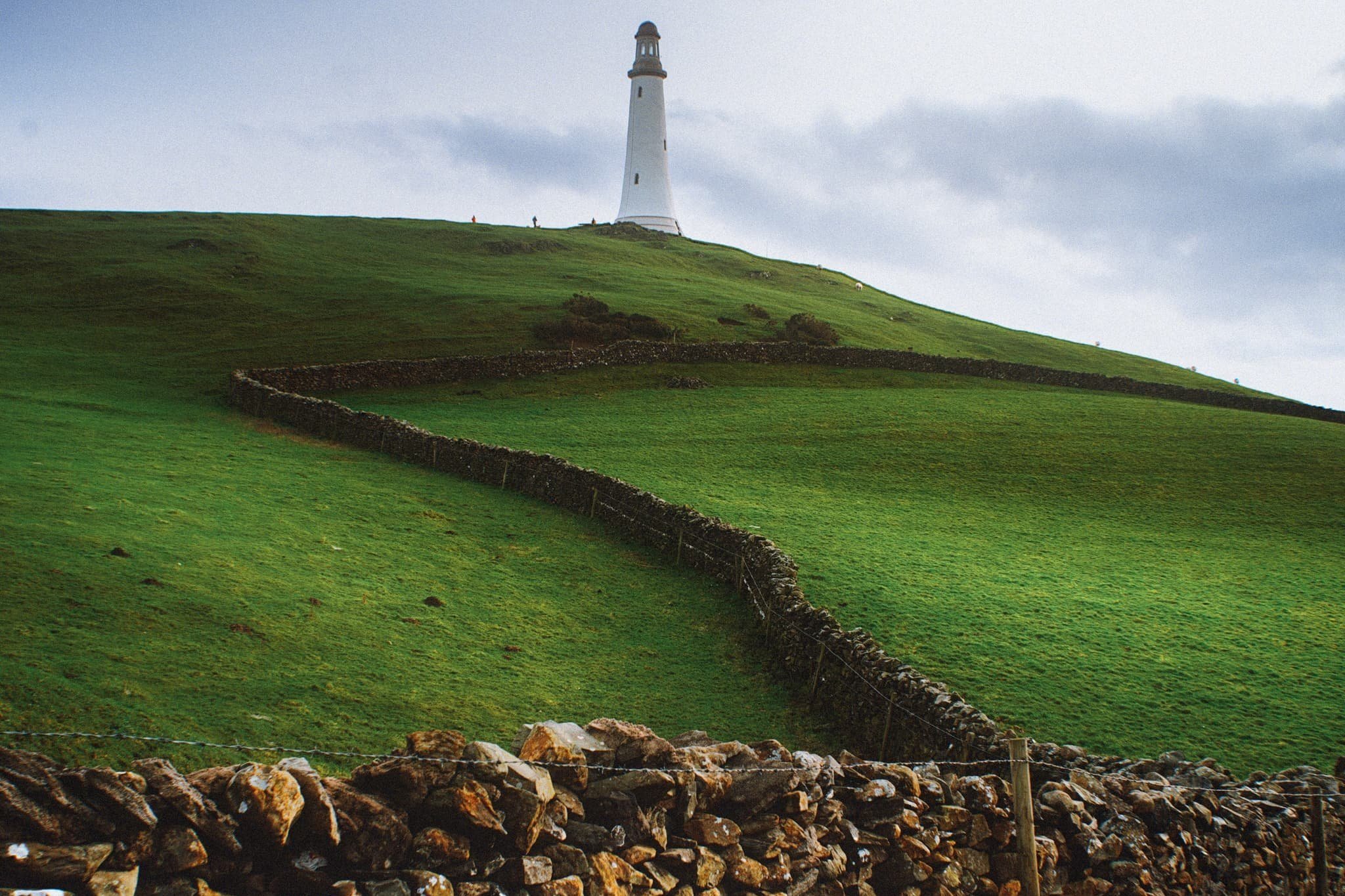
The Hoad goes by a few names. It’s officially known as the Sir John Barrow Monument, but is also known locally as “the Pepperpot”.
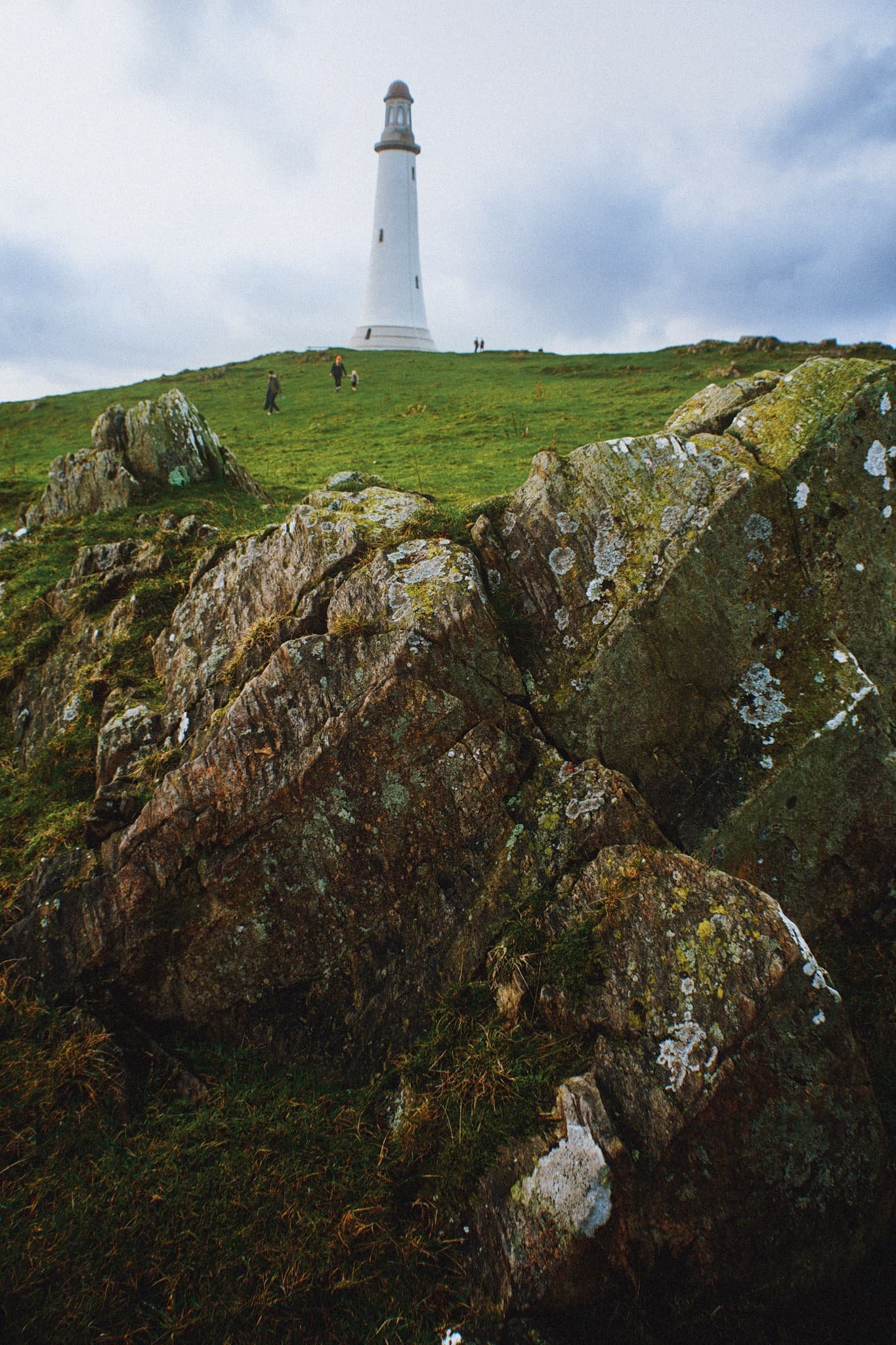
The Hoad was built in 1850 at a cost of £1,250, roughly £138,000 in today’s money. It was built to commemorate Sir John Barrow, who was a founding member of the Royal Geographical Society, and born in Ulverston. Though it looks like a lighthouse, it has never functioned as one.

The views from the Hoad are extensive and panoramic. Plenty of folk were out and about, enjoying a Boxing Day waltz and soaking in the views from the Hoad.
With my 70–210 mm equipped, I was able to pick small sections of Ulverston town. Here, looking southwest from the Hoad, the winding A590 road provides a focal point for the busy architectural landscape of Ulverston.
The view north from the Hoad couldn’t be more different. Rolling countryside, drystone walls, and sheep give way to the mighty Coniston Fells.
Northeast of Hoad Hill, another small hill provides sustenance to yet more sheep. In the distance, the Windermere fells partially obscure the Kentmere fells.
The way back to Ulverston town. You know me, I can’t resist a winding path.
A winding drystone wall catches my eye for a nice composition involving the Hoad.
Back in Ulverston, a wall mural tells the story of Sir John Barrow.
Did you enjoy these photos?
Arnside, Cumbria, Summer
I hope everyone had a lovely Summer Solstice.
I hope everyone had a lovely Summer Solstice.
When it comes to nature and the Summer Solstice, Lisabet and I are fortunate to have a variety of options on our doorstep. With a clear and cloudless evening ahead we decided on the expansive views offered at Arnside.
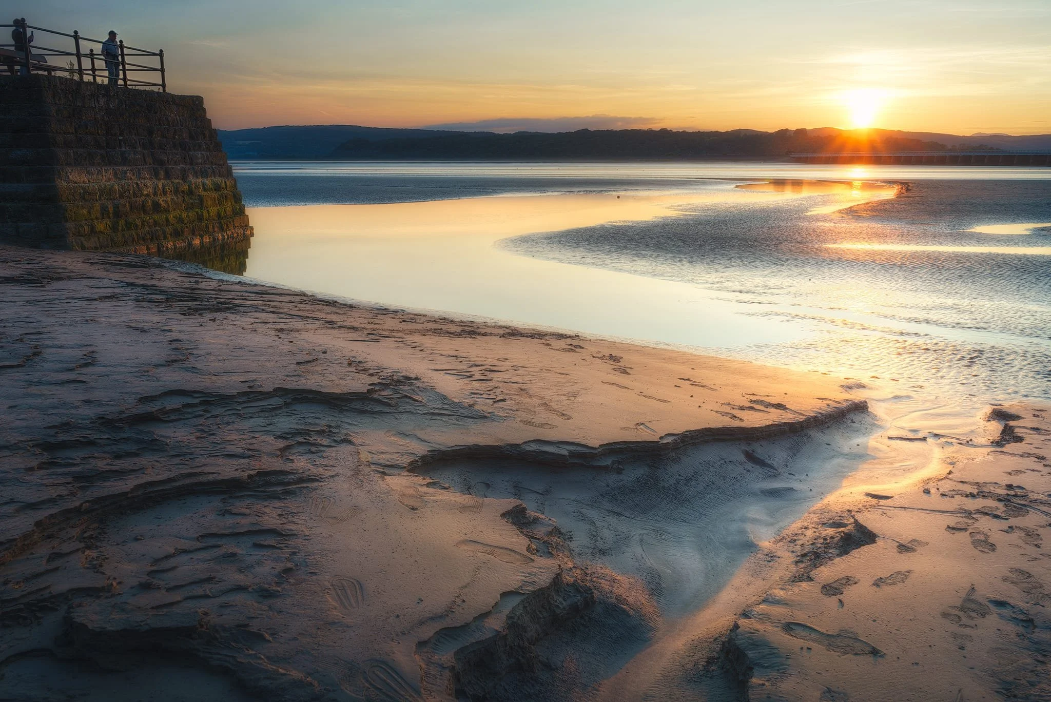
Arnside is a proper bonny seaside village located on the banks of the Kent Estuary, which eventually spills out into Morecambe Bay. Arnside features a ½ km long viaduct that carries trains across the estuary, and Arnside Tower; a peel tower, built in the 14th/15th century. Another curiosity is the Arnside Bore, a very fast rising tidal bore that occurs most high tides. People often watch the bore from the shoreline, marvelling at the faster-than-walking speed of the tide as Morecambe Bay refills the Kent Estuary every high tide.
For our evening, we just took a gentle meandering stroll along the shoreline of Arnside, enjoying the light and scenes as the sun set on the longest day of the year.
All photos taken on my Sony α7ii using my Sony FE 28–70mm f3.5–5.6 OSS zoom and Rokinon 14mm f2.8 ED AS IF UMC prime lenses. RAWs were developed in Lightroom, processed in Photomatix, and finalised in Photoshop.
Arnside, Cumbria, Summer by Ian Cylkowski is licensed under CC BY-NC-SA 4.0![]()
![]()
![]()
![]()
The gentle curves of the Arnside shoreline catches the golden sunset light, serving as a leading line towards the Arnside Viaduct and the distant Lake District fells beyond.
Probably my favourite shot of the evening. A small channel in the sand provides a nice leading line towards the sunset as onlookers from the pier enjoying the solstice.
Beached buoys provide a nice foreground subject as the sun gently sinks behind the fells.
A tighter composition focusing on this tidal channel as it reflects the fiery sunset light.
Back on the road, I equip my ultra-wide for this composition in the dying light of the day.
Did you enjoy these photos?
Longridge Fell, Lancashire, Summer
Being in nature with your best bud is one of life’s greatest treasures.
Being in nature with your best bud is one of life’s greatest treasures.
I recently had the privilege of heading Down South (and by Down South, I mean, Preston) to spend a weekend with my best mate, Fie. With the prospect of a gloriously sunny British summer’s day ahead, we decided on a wee little excursion up Longridge Fell, east of Preston.
I’ve not been up Longridge in, perhaps, over a decade. The one and only time I hiked Longridge Fell was to capture the sunset from the summit with another good friend of mine, Bamber. This was very early on in my photography journey, so I was very unsteadily shooting HDR photos.
In fact, here’s the photo:
This was shot on the 7th August, 2012.
So yeah, it’s been nearly a decade.
Longridge Fell is the most southerly hill in England that has the word “fell” in its name. As you may have read previously in this blog, “fell” in Northern English dialects refers to a hill or a mountain, and can be traced from the Old Norse word fjall, which means “mountain”.
The fell’s name is quite literal as it truly is a long ridge, rising from the town of Longridge to its summit in 4.5 miles. Researching Longridge Fell caused me to learn a new word, which I’m always happy with: cuesta. This is a Spanish word and geographically refers to a hill or ridge with a gentle slope on one side, and a steep slope on t’other, which Longridge Fell definitely fits.
On this day, and for this walk, we started from Jeffrey Hill car park, which is already 200m-ish a.s.l. Only another 150m worth of ascension was needed to reach the summit.
The day was gloriously clear with nary a cloud in the sky. Like in Cumbria, Lancashire has seen barely a drop of rain in a good month or so. As a result, the fell—though normally boggy—was remarkably dry. This didn’t stop Fie from managing to sink one of her shoes into a surprise bog…
All photos shot on my Sony α7ii using my Sony FE 28–70mm f3.5–5.6 OSS zoom and Vivitar “Series 1” 70–210mm f2.8–4.0 zoom lenses. RAWs developed in Lightroom for iPad, then finalised in Affinity Photo 2 for iPad.
Longridge Fell, Lancashire, Summer by Ian Cylkowski is licensed under CC BY-NC-SA 4.0![]()
![]()
![]()
![]()
Across the rushes, grass, and valley, the nose of Totridge Fell (496 m/1,627 ft) on the southern edge of the Forest of Bowland becomes apparent.
As we level out near the summit Fie does her best meerkat impression, scoping out the view of the Ribble Valley.
Looking back west along the drystone wall. The clear atmosphere means we can easily pick out the city of Preston, and also Blackpool Tower 20-odd miles away.
Now equipped with my 70–210mm lens, I spot a composition of three solitary trees over the wall, seemingly standing guard over the Ribble Valley.
The moorland that makes up most of Longridge Fell allows for more minimalist landscape compositions, even in the peak of the summer day.
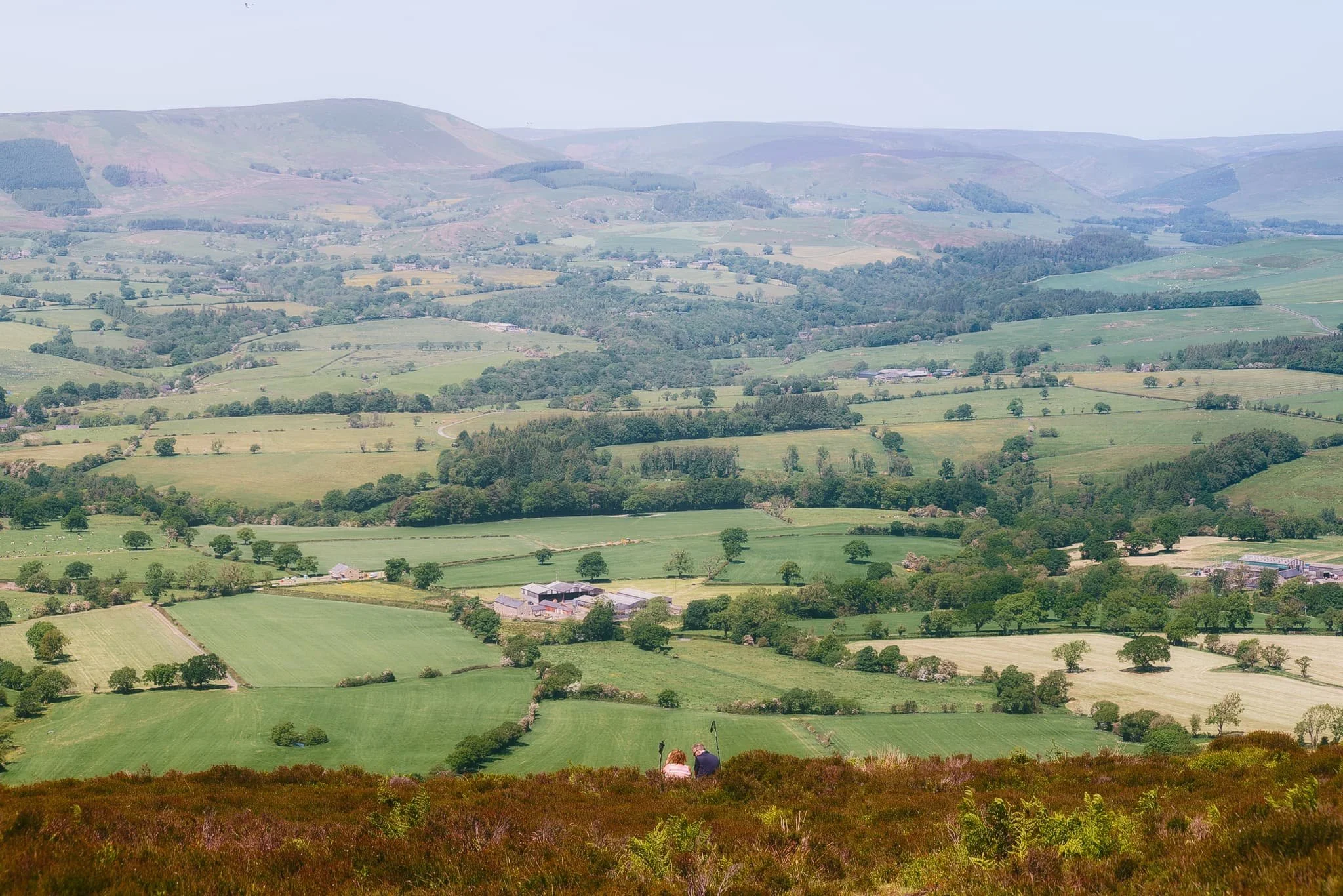
Looking down the sheer drop from near the summit, I spy a couple resting in the heather and bracken, enjoying the view across the valley towards the Forest of Bowland.
From the summit of Longridge Fell, I line up a composition looking east along the drystone wall and the forest edge.
Rather than simply heading back the way we came, we cut through the woodland on top of Longridge Fell. This allowed for some beautiful deep woodland compositions as the summer sun penetrated the trees in atmospheric ways.
One last look back at the summit, across all the ferns and picking out the solitary tree I shot earlier.
Did you enjoy these photos?

Cunswick Scar, Cumbria, Winter
The first snow of the season has arrived.
The first snow of the season has arrived.
Fortunately—living where I do—there are plenty of quick routes one can take from the town centre to ascend some nearby hills and check out the expansive wintery views.
The Lake District fells? Howgills? Barbondale fells?
They did not disappoint.
Atmosphere was clean and clear. You could almost reach out and touch the mountains.
All photos taken on my Fujifilm X-T2 using my Vivitar “Series 1” 28–105mm f2.8–3.8 zoom lens. Shot using the Classic Chrome film simulation, edited in Capture One for iPad and finalised in Affinity Photo 2 for iPad.
Cunswick Scar, Cumbria, Winter by Ian Cylkowski is licensed under CC BY-NC-SA 4.0![]()
![]()
![]()
![]()
We’ve had a week of sub-zero temperatures, resulting in snow. It’s also largely been dry and completely clear, so it was no wonder lots of other people (and their furry friends) were out and about enjoying the views.
My lovely Lisabet, enjoying the beautiful light and atmosphere of the Kentmere fells.
For others, the outdoors are best enjoyed whilst exercising.
Up on the summit of Cunswick Scar, the Coniston Fells positively glow with snow.
Zooming out to capture the entire expanse of the Lake District fells. Not all of it covered in snow as of yet.
However, looking towards the Howgills… wow. Clouds washing over them like a waterfall. Glorious light, highlighting the beautiful contours of the Howgills.
Navigating the steep path around Helsfell Nab towards these barns was… tricky. A popular trail means compacted snow that became frozen over and over again.
Only about 1pm at this point, but already the sun was setting and drenching the land in warm winter light.
Back down to the beautiful Auld Grey Town.