
Cunswick Scar, Cumbria, Winter
The first snow of the season has arrived.
The first snow of the season has arrived.
Fortunately—living where I do—there are plenty of quick routes one can take from the town centre to ascend some nearby hills and check out the expansive wintery views.
The Lake District fells? Howgills? Barbondale fells?
They did not disappoint.
Atmosphere was clean and clear. You could almost reach out and touch the mountains.
All photos taken on my Fujifilm X-T2 using my Vivitar “Series 1” 28–105mm f2.8–3.8 zoom lens. Shot using the Classic Chrome film simulation, edited in Capture One for iPad and finalised in Affinity Photo 2 for iPad.
Cunswick Scar, Cumbria, Winter by Ian Cylkowski is licensed under CC BY-NC-SA 4.0![]()
![]()
![]()
![]()
We’ve had a week of sub-zero temperatures, resulting in snow. It’s also largely been dry and completely clear, so it was no wonder lots of other people (and their furry friends) were out and about enjoying the views.
My lovely Lisabet, enjoying the beautiful light and atmosphere of the Kentmere fells.
For others, the outdoors are best enjoyed whilst exercising.
Up on the summit of Cunswick Scar, the Coniston Fells positively glow with snow.
Zooming out to capture the entire expanse of the Lake District fells. Not all of it covered in snow as of yet.
However, looking towards the Howgills… wow. Clouds washing over them like a waterfall. Glorious light, highlighting the beautiful contours of the Howgills.
Navigating the steep path around Helsfell Nab towards these barns was… tricky. A popular trail means compacted snow that became frozen over and over again.
Only about 1pm at this point, but already the sun was setting and drenching the land in warm winter light.
Back down to the beautiful Auld Grey Town.
Did you enjoy these photos?
Bowderdale, Howgills, Cumbria, Summer
Today required… flexibility.
Today required… flexibility.
My initial plan for the day was to get up early and head to Kentmere for a lovely walk around the valley and its fells. It’s usually a trial to access Kentmere; the road to it from Staveley is long and narrow with few passing places. Then, once you’re at Kentmere, the only place to park is outside the church, fit for maybe 4–5 cars.
Welp, after an interesting challenge driving the narrow road all the way to Kentmere—dodging and manoeuvring past cars and tractors—I arrived at the church to find it completely full of cars.
At 9 o’clock in the morning on a work day.
So that scuppered those plans. What to do instead? I contemplated trying for Longsleddale instead, but that’s an even longer valley with a narrow one-in-one-out road.
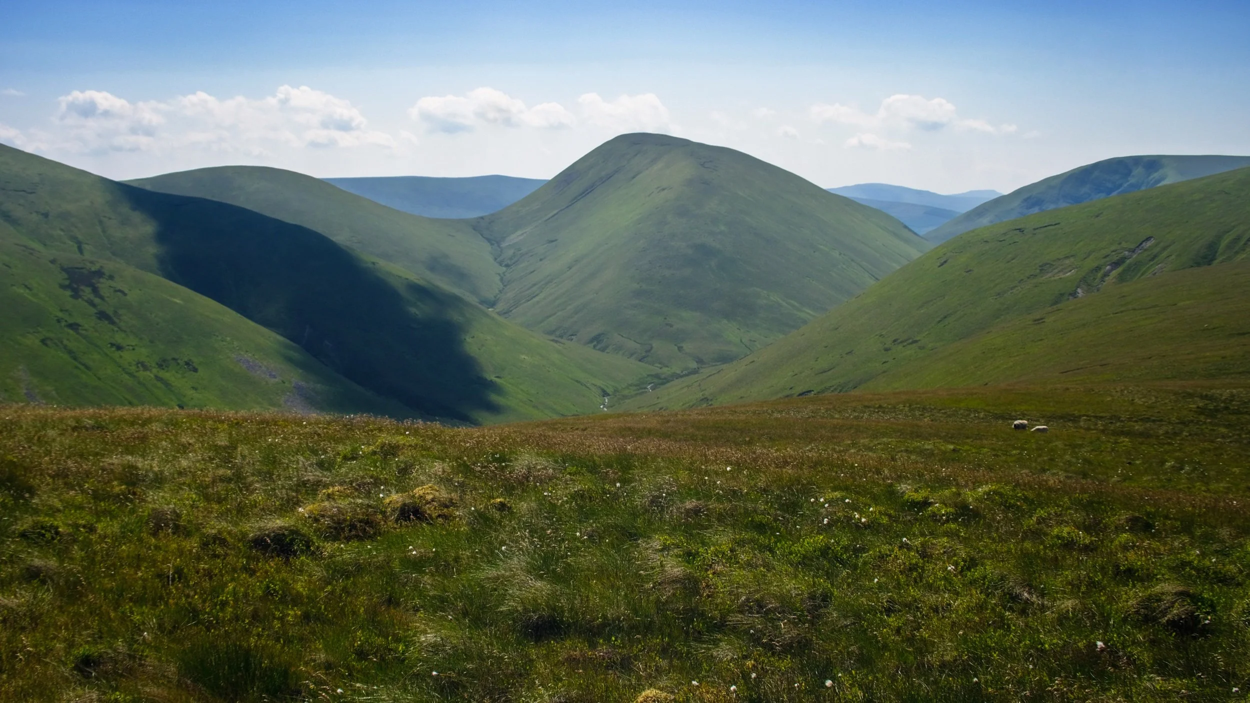
I realised that we’ve reached the time of year where the Lake District is always going to be busy, no matter where you go or when. So instead I navigated back to Kendal and took the A685 towards the Howgills. As I was approaching them, thinking of where to explore, I remembered the Bowderdale valley in the northern Howgills. It’s been a long time since I walked in that valley; time to revisit! In fact, it has been exactly four years to the day since I last explored Bowderdale.
Bowderdale is a long north-to-south valley in the northern part of the Howgills. It’s very quiet compared to the Howgills near Sedbergh. It’s also the source of the River Lune, which winds its way north out of the valley, turns sharply west, then gouges its way south where it has carved out the impressive Lune Gorge that now houses the M6 motorway.
I initially fancied a simple hike down the valley bottom. However, the closer to the valley I got, the more I was attacked by a variety of biting flies and insects. I quickly abandoned this idea and retraced my steps back to where the trail connects with the Dales High Way. This would take me up and over West Fell and I would see what I could see of Bowderdale from above.
Turned out to be a good idea! The weather was glorious.
All photos taken on my Fujifilm X-T2 using my Vivitar “Series 1” 29–105mm f2.8–f3.8 zoom lens. Images made 90% in-camera using the Velvia film simulation, finished off in Affinity Photo.
From my car outside Bowderdale village, the scenery was already looking bucolic.
The country lane to Bowderdale village and ultimately Bowderdale itself. The fell in the distance is West Fell (542 m/1,778 ft), which flanks the western side of the valley.
As I was passing through Bowderdale village I could hear some scuffling on the road behind me. I was being followed by a small flock of sheep! I wonder if they were mistaking me for a local farmer or shepherd?
It felt like I was playing a game of Grandma’s Footsteps/Red Light, Green Light/Statues with the sheep. I would turn to look at them, and they’d stop and suddenly find the grass very interesting.
Leaving Bowderdale village, the path climbs up and I catch my first glimpse of Yarlside (639 m/2,096 ft), all the way down Bowderdale.
This was as far as I got on the trail towards the valley bottom, before I was mobbed by biting insects. Time to retrace and look for a different route.
I instead elected for the Dales High Way, which take me up and over West Fell above Bowderdale. Here’s the scene looking back at my progress.
As I near the summit of West Fell, the views west towards Bush Howe above the Langdale valley open up.
On the West Fell ridge, Yarlside comes into view again and the temptation to get a better look proves strong.
Above Yarlside a solitary puffy cloud catches my eye.
Another cloud makes its presence known above Randygill Top.
I neared the eastern edge of West Fell to get a sense of the drop down to Bowderdale.
On the western side of West Fell, East Grain and West Grain join underneath Cobles (534 m/1,751 ft) to become Langdale Beck, which has carved out this beautiful valley.
Looking back north along the shoulder of West Fell to admire the view and track my progress.
It must be noted that this route is probably best tackled in the summer. The trail from the village to West Fell isn’t properly paved, and the fell top shows signs of bogs. This will be a wet and muddy experience in any other season.
Another look west towards Langdale before I crest the summit of West Fell and examine the scene.
The trail drops off West Fell and carries on towards Hazelgill Knott (578 m/1,896 ft) and beyond to the rest of the Howgills. That would be for another day. It was getting awfully hot.
Yarlside in full, which marks the head of Bowderdale. The path at the bottom of Bowderdale skirts around the western flank of Yarlside before dropping down Cautley Spout, one of England’s tallest waterfalls.
I returned to Bowderdale village, and ultimately my car, via the same route, snapping this beautiful bucolic scene.
Bowderdale, Howgills, Cumbria, Summer by Ian Cylkowski is licensed under CC BY-NC-SA 4.0![]()
![]()
![]()
![]()
Did you like these photos?
Howgills & Yorkshire Dales, Winter
The week leading to these photos and this post has been… frustrating.
The week leading to these photos and this post has been… frustrating.
On Monday my left shoulder grew progressively stiff and painful. By the evening I was in a lot of pain and I ultimately did not get a second of sleep. Looks like I did another one of my favourite Fit-During-My-Sleep-And-Discolate-A-Limb-Whilst-Shredding-Muscles.
So most of this week has been spent fighting pain and keeping the shoulder immobilised. Apart from the constant pain and lack of sleep being exhausting, it’s also boring.
By the weekend, I’d finally got my pain levels under control and was starting to regain movement in my shoulder. Sunday arrived bright and clear, with blue skies promising a beautiful day. Lisabet took us for a drive through Sedbergh and the Yorkshire Dales, occasionally parking up for short walks and photo snaps. I really needed it.
All photos shot on my Fujifilm X-T2 using my Fujinon 23mm f/2.0. Images developed using RNI Films’ Velvia 100F emulation.
One of my favourite views of the Howgills can be shot from the A684, as you crest the hill past Lily Mere. It felt so good to finally see a clear blue sky after all the storms we’ve endured.
Happily there’s a couple of lay-bys alongside this part of the A684 where one can park and snap some glorious photos. Onwards into the Yorkshire Dales.
Beyond Sedbergh and heading further into the Yorkshire Dales, another viewpoint of the Howgills can be obtained, now looking at their southeastern profile. This is a little area known as Tom Croft Hill.
Further into the Yorkshire Dales, closer to Hawes, we stopped off at the small layby near Holme Heads Bridge for a wee jaunt to check out the beautiful Cotter Force. It was lovely to see the waterfall with a decent amount of water flowing through it.

Everywhere we look, signs of spring are arriving.
When you’re in the Yorkshire Dales, you can always count on an abundance of bare stone barns dotted about the land.
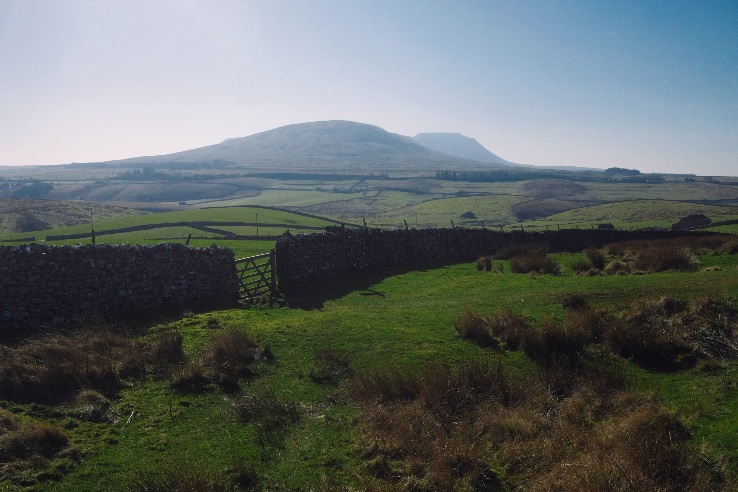
We skirted around the town of Hawes and hopped onto Blea Moor Road, which ultimately takes you to Ingleton and back onto the A65. Views of the magnificent fell Ingleborough entice you all the way along the road.
The area around the Ribblehead Viaduct was jammed with cars. Thankfully, we managed to find a small space to park up and snap some photos of this incredible architectural feat, situated underneath the highest peak of the Yorkshire Dales, Whernside.
Whernside’s eastern face, with a smidge of snow still clinging on. Barely a cloud in the sky.
Howgills, Yorkshire Dales, Summer
It was time to come back to the Howgills.
It was time to come back to the Howgills.
Back in April this year, 2021, Lisabet and I made our first hike up onto the Howgills, summiting Winder (473 m/1,552 ft), the fell that directly overlooks the beautiful Yorkshire Dales town of Sedbergh. It wasn’t hard, during that hike, to gawp at the next fell along the ridge from Winder, namely Arant Haw at 605 m. We vowed to return and tackle Arant Haw.
Today was that day.
The forecast was for clear skies and pushing 20°C, but when we arrived at Sedbergh for around 9am it was relatively chilly and cloudy. As we began our ascent up the Dales High Way up into the Howgills—and the views opened up—it became apparent that the cloud base still hadn’t quite cleared the fell tops. This resulted in amazing light and weather conditions, significantly slowing down our hiking progress (but all for good reason).
After a proper good pull, we managed to summit Arant Haw as well as add on the smaller fell of Crook on the way back down.
What a crackin’ day.
All photos shot on my Fujifilm X-T2 using two of my prime lenses: a Samyang 35mm f/1.2 and a Laowa 9mm f/2.8. Developed with RNI Films’ Kodak Portra 160 profile.
The way marker indicates the Dales High Way, the main trail that takes you up into the Howgills from Sedbergh. The fell on the left is Crook.
This was the kind of light show we were subject to on our way up the Howgills. The cloud base was clinging to the top of the Garsdale and Dent fells, and as the sun was rising they were swirling as they burning off.
Shapely Winder from the Dales High Way. Not our destination for the day.
A fell runner and her anxious dog passed us on their way across Settlebeck Gill and up Crook.
Plenty of lambs and young sheep around the Howgills, warily watching us we disturbed their grazing.
It wasn’t long before we spotted more people heading up the trail behind us. We weren’t in a rush. The light and views were too good to miss.
The view looking up Settlebeck Gill. That little hill in the distance with the trail running over it? That’s our destination: Arant Haw.
Looking down Settlebeck Gill, the light and views just get better and better.
The small Frostrow Fells catching the morning light, whilst the Dent fells recede in shadow. Astounding.
The steep folds of Settlebeck Gill, leading down to Sedbergh and the Barbondale fells beyond.
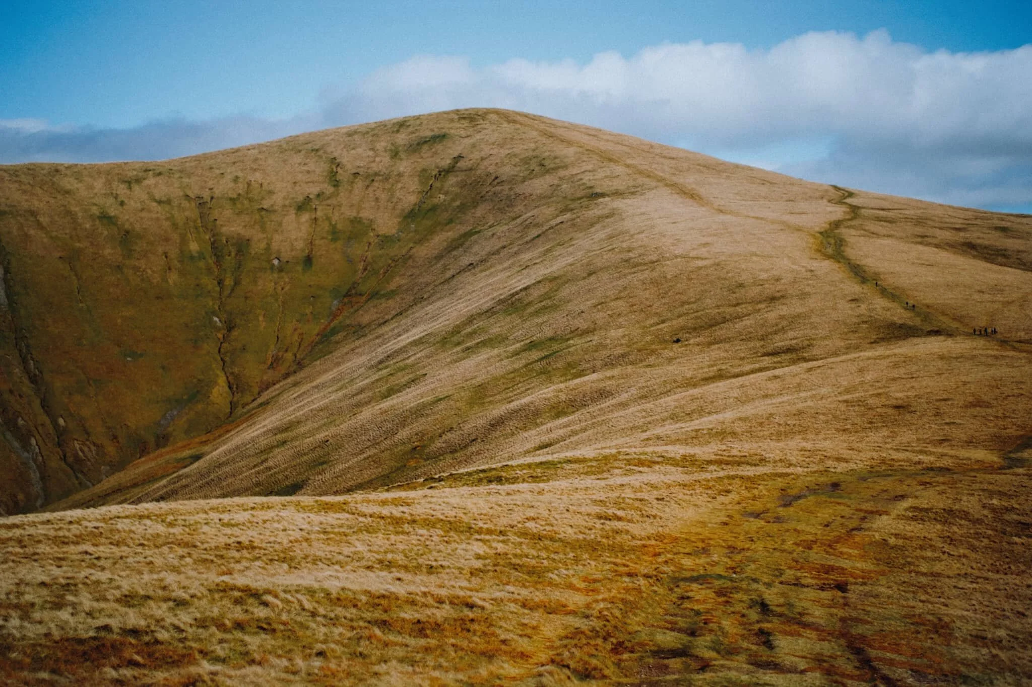
After reaching the plateau above Settlebeck Gill, our destination becomes immediately obvious: Arant Haw.
Looking back to Winder, morning light scanned across the fells and I waited for it to reach the summit of Winder before snapping this composition.
The view north from the summit of Arant Haw. Good heavens.
The views north from Arant Haw take in a succession of Howgills peaks and valleys, felltops such as Calders (674 m/2,211 ft), Bram Rigg Top (672 m/2,205 ft), The Calf (676 m/2,218 ft, highest point of the Howgills), and White Fell (636 m/2,086 ft). The clouds clung to the felltops as the day brightened
Looking down the gill of Swarth Greaves Beck eastwards. Views for miles and miles.
Just astounding.
The western spur that juts out from Arant Haw gives you an indication of the steepness of the fell’s western face.
Zooming in more, I love this arrangement of horizontal and diagonal lines created by the fells and gills.
Time to head down Arant Haw. The conditions looking back to Winder and Sedbergh were starting to brighten up significantly.
The little knobbly fell to the right is our next destination: Crook. There’s not any “official” path to the fell, but that’s no major bother anyway. The Howgills is all Open Access Land.
Swaledale and Rough Fell sheep enjoy the views towards Garsdale as much as we do, it seems.
Even though Crook is only 450 m high or so, the views from its summit are no less impressive.
From Crook it was even possible to make out the back of Wild Boar Fell in Mallerstang, looking northeast.
Looking back up to Arant Haw from around Crook summit, the light getting brighter and brighter.
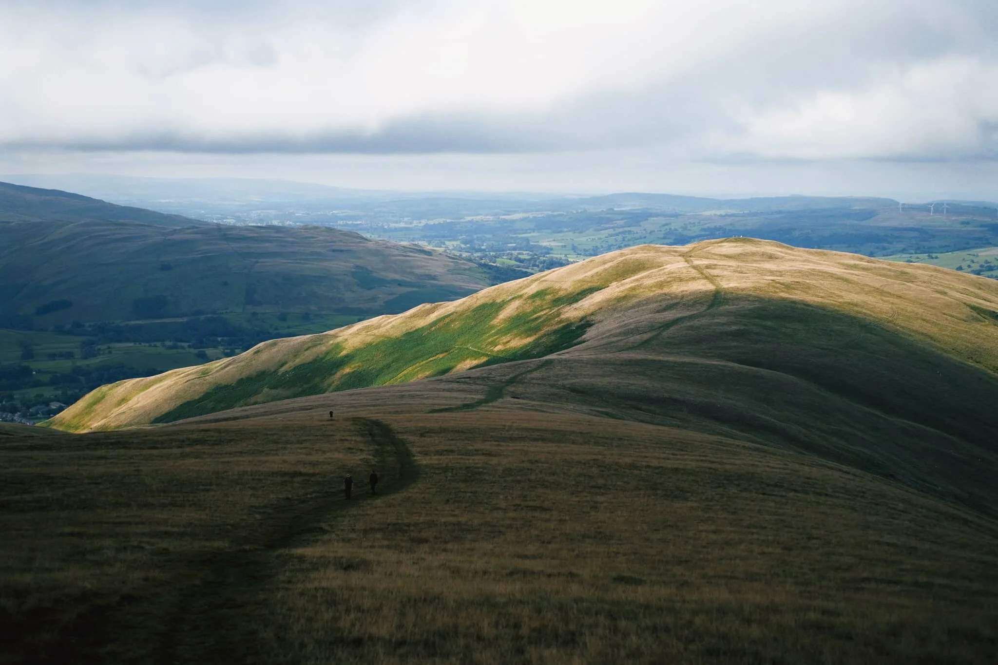
It was time to come off the Howgills, Lisabet leading the way ahead. We decided on the Soolbank route off Crook, heading down into Settlebeck Gill.
Once we were alongside the banks of Settlebeck Gill, it was simple enough to follow the gill all the down until you could cross and rejoin the Dales High Way back into Sedbergh.
Settlebeck Gill is an impressive sight. The little people hiking the Dales High Way give an indication of scale.
The way back down into Sedbergh, the fells now free of clouds.
Sedbergh, Yorkshire Dales, Summer
After Saturday’s hike around Cunswick Fell for some glorious summer scenes, we sought more near the beautiful town of Sedbergh.
After Saturday’s hike around Cunswick Fell for some glorious summer scenes, we sought more near the beautiful town of Sedbergh.
I’ve commented before about the beauty of the Howgills and how Lisabet and I have barely touched them. The comely bumps and folds of these hills will see more of our footsteps in due course. But for this occasion I found a lovely hike that took us up towards the foot of the Howgills, through a couple of farms, and across some incredible wildflower meadows. We then joined the River Rawthey near Buckbank Farm and followed the river all the way back to the town.
A nice 5-mile circular, all in all.
Conditions, light, and scenes could not have been more cooperative for photography. The wildflower meadows beneath the Howgills were glorious.
All photos taken on my Fujifilm X-T2 with my Samyang 35mm f/1.2 lens. Images were made 80% in-camera using a customised Velvia film simulation, with minor edits in Lightroom and Affinity Photo afterwards.
The first of many wildflower meadows above Sedbergh we encountered, with Middleton Fell (609 m/2,000 ft) in the distance.
In the next field a few young bullocks and cows were giving us an inquisitive stare or two. We gingerly navigated around them, giving them plenty of room, but I did manage to fire off one photo.
The views across to Garsdale immediately started to open up. What glorious scenes.
Making our way northeast on the trail towards Ghyll Farm, the fell Crook (461 m/1,513 ft) momentarily darkens under the shade of a passing cloud.
I couldn’t keep my eyes off the sprawling views towards Garsdale. We really do live in a beautiful country.
I spotted this trio of trees with pleasing spacing between them, so I framed up for a composition with Soolbank in the gap.
A field full of buttercups and Knott (429 m/1,407 ft) bulging in the distance. Our destination is the stile over the wall, just to the right of centre.
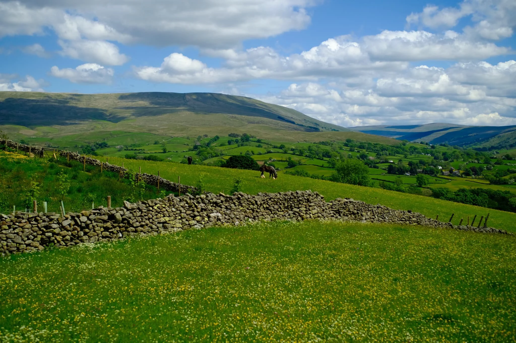
Just one of many meadows in the foothills of the Howgills, brimming with buttercups. Above, clouds pass over Baugh Fell (678 m/2,224 ft), painting their own shadows onto the hill.
I paused at the top of climbing over the stile to capture this expansive and awe-inspiring view of Baugh Fell and Garsdale, with the characteristic drystone walls of Northern England and a horse grazing for good measure.
Some of the farm houses underneath the Howgills are a good two or three centuries old.
I largely don’t bother with focus stacking anymore. Opened this one all the way to f/1.2, focused on the fell and let the lens do the rest. All the buttercups. This would make a good smartphone wallpaper, actually.
After navigating through Stone Hall Farm we aimed for Buckbank Farm, which would allow us to join the River Rawthey. But not before taking a photo of this frankly ridiculous scene towards two of the southern Howgills, Crook and Knott, with meadows full of buttercups.
Approaching Ellerthwaite Farm, which would lead us to Buckbank and thus the River Rawthey.
Following on from Buckbank Farm we joined the bridleway southwest, which broadly follows the River Rawthey. Our next destination to look out for was Straight Bridge, which we would climb underneath to stay on the bridleway towards Sedbergh.
I always enjoy cows and bulls giving me The Stare…
Cows, trees, the Howgills, and fluffy clouds. A true Northern English summer country scene.
An interesting tree stump provided me with a lovely subject to frame in this composition.
The farm of Scrooge House with its fields of buttercups and the Howgills behind.
After pausing for a spot of packed lunch, we followed the bridleway by the river all the way towards New Bridge.
A rich and vibrant scene of summer colour I spotted by one of the becks that flows into the River Rawthey.
The way back to Sedbergh town. You’ve got to admit, it’s a proper lovely town, isn’t it?
Winder, Howgills, Cumbria, Spring
We’ve neglected the Howgills for too long.
We’ve neglected the Howgills for too long.
On this Good Friday we elected to stay away from the Lake District, expecting visitor numbers to sharply increase. We did want to stay within the same council area, though. So we ventured east over the M6 and into Sedbergh, the beautiful bookish town at the foot of the Howgills.
It might be reasonable to state that the Howgills as a landscape tends to get overlooked, or even ignored, in favour of nearby neighbours such as the Lake District and the Yorkshire Dales. Lisabet and I have certainly been guilty of this assumption. But the Howgills has a lot of beautiful wandering to offer, and we’ve barely scratched the surface.
We exited the town onto Joss Lane, which leads onto the Dales High Way. Then it was a simple matter of following this footpath and its incredible views of Settlebeck Gill all the way onto the plateau, before turning back sharply to reach the summit of Winder (473 m/1,552 ft).
A glorious spring’s day was in full effect, with clear and deep blue skies all around.
And there are many more of the Howgills to check out.
All photos taken on my Fujifilm X-T2 using a Samyang 35mm f/1.2 lens and an adapted Pentax SMC 55mm f/2.0. Developed using RNI’s Kodachrome film profiles.
Sedbergh is a beautiful little town.
After exiting Joss Lane we merged onto the Dales High Way, soaking in the beautiful spring sun as we did.
There were plenty of others out and about on the Howgills too, and on such a beautiful day I don’t blame them.
Looking back the way we came.
A well-positioned bench offers walkers a rest and a view of the Dentdale fells.
We were keen to stay on the main footpath, but others elected to ascend the Winder summit as quickly as possible.
With every step the panorama opened up more and more. It was hard to maintain a forward momentum up the fell path when these views commanded our attention behind us all the time.
The way forward. Nary a cloud int’ sky.
Here we’re nearing the first main plateau of the Dales High Way, which also signalled us to take a sharp left in order to reach the summit of Winder.
One last look back down, with the full extent of Settlebeck Gill below, the Sedbergh countryside in the middle distance, and the Dentdale fells of the Yorkshire Dales in the background.
Fell ponies grazing peacefully on the flanks of Green Mea.
What a sight. The Dales High Way carries on around the flank of Arant Haw (605 m/1,985 ft), a beautifully sculpted fell with a precipitous southwestern face.
Our destination meant turning away from the Dales High Way, back to the southwest towards Winder. Along the way I keep snapping the views over to the heart of the Yorkshire Dales.
Across Settlebeck Gill is Winder’s easterly neighbour, Crook (461 m/1,513 ft). Far in the distance are the Mallerstang fells.
And… summit. On a clear day, such as we enjoyed, the views take in the Lake District fells and even Morecambe Bay, 32 km away.
After a flapjack and some water whilst sheltered underneath the trig point from the wind, we followed the track back down the southwestern shoulder of Winder.
Layers upon layers of hills and valleys in the Howgills. In fact, that’s where the Howgills get their name from. “How” comes from the Old Norse haugr meaning “hill”, and “gill” comes from the Old Norse gil meaning a “narrow valley”.
The winding track back to Sedbergh via Lockbank Farm. The round mound in the distance is Aye Gill Pike (556 m/1,824 ft).
Ostensibly looking back at the way we came, but more than I shot this composition for the winding drystone wall. That’s right.
So many lambs around. Always a wonderful sight to see and sound to hear.
Swaledale lambs, being adorably playful.
My lovely Lisabet, enjoying a drop of Sherry in her friend’s garden post-walk.