Bowscale Tarn, Lake District, Summer
We kicked off Father’s Day weekend by revisiting the Mosedale valley in the Northern Fells of the Lake District.
We kicked off Father’s Day weekend by revisiting the Mosedale valley in the Northern Fells of the Lake District.
The last time we hiked Mosedale was back in March of this year, during a visit to my Dad’s. It was our first time in this quiet valley and we were floored with the sights and views. The nice weather probably helped.
This time we endeavoured to hike the public bridleway up Mosedale’s southern side. Following this takes you all the way to Bowscale Tarn and, if you want, onwards up to Bowscale Fell (702 m/2,303 ft). Adventurous fell walkers can then extend this hike by venturing further south to summit Blencathra itself (868 m/2,848 ft).
We decided not to summit Bowscale Fell this time round; the humidity was proving quite draining. Nevertheless, Bowscale Tarn was delightful. It’s flanked on all sides except the north by sheer walls of crag. The tarn is reportedly 60 ft deep and—so the legend goes—is home to a pair of talking, immortal fish.
The more you know!
All photos shot on my Fujifilm X-T2 using my three prime lenses: a Samyang 35mm f/1.2, a Laowa 9mm f/2.8, and an adapted Pentax SMC 55mm f/2.0. Images 80% developed in-camera using a customised Provia film simulation, with minor finishing edits in Lightroom and Affinity Photo.
After parking up at the small car park, generously provided by the Quaker Meeting Hall, I had to quickly snap this photo. It’s such an English Lake District village scene.
Tiny Mosedale village, nestled underneath Carrock Fell (661 m/2,169 ft).
Onto the public bridleway near Bowscale hamlet and up we go! We certainly weren’t the only ones on this trail, and nor should we expect to be given it’s summer in the Lake District. Nevertheless, this part of the national park definitely sees fewer visitors.
The flat-bottomed floor of Mosedale, perfectly sculpted by historical glaciers.
Looking back, I spot Lisabet nabbing a photo of a bee on some thistle. The cloudy conditions increased the humidity of the day, and soon we were rather damp in sweat.
Plenty of Swaledale ewes about in Mosedale, with their spring lambs getting to know the valley and the fells.
Around this part of the bridleway, the gradient starts to increase as we near Bowscale Tarn. I paused to catch me breath briefly, and looked back to shoot the light scanning across the shoulder of Bowscale Fell.
Bowscale Tarn is near. The bridleway skirts around this moraine “lip” that keeps the water where it is. Ahead is the wall known sensibly as Tarn Crags.
We made it to the tarn, preceded by fellow hikers and families enjoying the delights of nature.
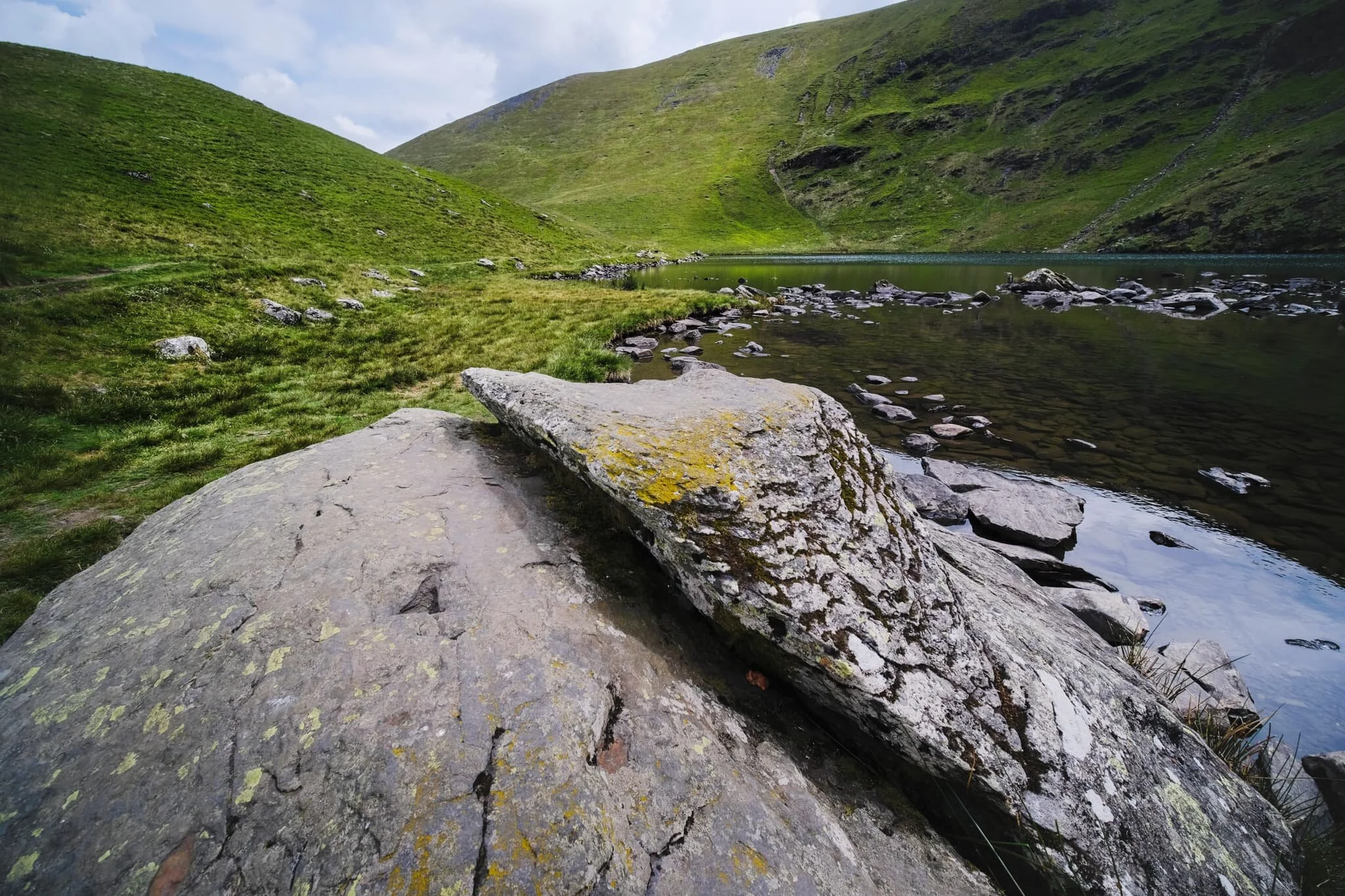
An unnamed gill cuts through the crags of Bowscale Fell and drops into the deep and dark water of Bowscale Tarn.
Near the outflow of the tarn, which drops to the valley floor as Tarn Sikes, one can find some impressive boulders offering compositional interest.
A wider view of Bowscale Tarn, surrounded by Tarn Crags. The summit of Bowscale Fell is just up and to the left.
Lisabet and I gingerly navigated around the shore of the tarn, picking out photos along the way. Underneath Tarn Crags, I looked back to the outflow of the tarn and made this composition incorporating the distant summit of Carrock Fell.
Even on the steep slopes of Tarn Crags, you’ll find ewes and their lambs.
This part of the shoreline marks the end of our way around the tarn. A brief opening in the clouds above softly illuminates the scene.
There were plenty of kids hopping, skipping, and jumping around the rocks and boulders of the tarn.
After pausing for lunch, it was time to head back down. I equipped my 55mm lens for some longer perspectives, including this one of Lisabet and the northern side of Mosedale.
Salutations to the splendour of nature? Or stretching her shoulders and back out?
After following the clear, yet admittedly steep, path directly back down to the valley floor, we paused at the footbridge to admire this view all the way back up Mosedale.
Roundhouse Farm marks the point where we join the path on the northern side of Mosedale and head back east to the car. The earliest parts of the farm date back to 1702 AD.
Swaledales were being smart and sought shelter from the sun underneath the trees and in the shade of the drystone walls. They look about ready for a good clipping (shearing).
Behold! Some blue sky at last!
The full extent of Mosedale from near the village. What a crackin’ day.
Pandemic Peregrinations: Mosedale, Lake District, Spring
My Dad’s been vaccinated.
My Dad’s been vaccinated.
This is a relief for me as Dad’s a Type II Diabetic and thus Clinically Extremely Vulnerable.
As he’s in our Support Bubble we went to check in on him this weekend, spending a large part of the day in the valleys of the Northern Fells near where he lives.
The Northern Fells is an area of the Lake District Lisabet and I have barely touched but we’re still starting to get round to it. South of Carrock Fell and Caldbeck Common, on Blencathra’s eastern flank, one can find two valleys ripe for hiking. On this occasion we picked Mosedale, and what a beautiful valley it is.
Mosedale is a west-east valley that begins life underneath Knott (710 m/2,330 ft) and its subsidiary top Coomb Height. Here the two rivers Grainsgill Beck and Blackhazel Beck join together underneath Knott and flow eastward, which has historically gouged out a steep valley with a flat floor.
The main path through the valley is on its southern flank, which gently ascends before reaching Bowscale Tarn. We chose the northern track through the valley this time, just to check out the scope of Mosedale. I think Lisabet and I will definitely return to hike the southern path.
The sun was out, white fluffy clouds were in the sky, a very light wind caressed our faces… it was a glorious day for a Lake District spring hike.
Photos taken on my Fujifilm X-T2 using my three lenses: a Samyang 35mm f/1.2, a Laowa 9mm f/2.8, and a Pentax SMC 55mm f/2.0. Developed using RNI’s Kodachrome film profiles.
I agree that this photo isn’t all that interesting, but I largely shot it to record probably Britain’s smallest footpath sign. Barely knee height!
Dad, with his own Fujifilm camera setup, enjoying the glorious sights and wonderful light conditions.
Our first real sight of the full extent of the Mosedale valley. Absolutely beautiful.
A composition shot across the valley towards Mosedale’s southern flank. Hidden by the “lip” near top-centre is Bowscale Tarn.
At Roundhouse, roughly halfway along Mosedale. Here the valley starts to pinch as we near the head towards Coomb Height, the fell in the distance on the right.
There’s quite a bit of scree around the head of Mosedale, including some sizeable boulders. This one caught my eye for the unusual patch of heather growing out of it.
I went for wee scramble off the track to nab a composition of some of the scree and vegetation.
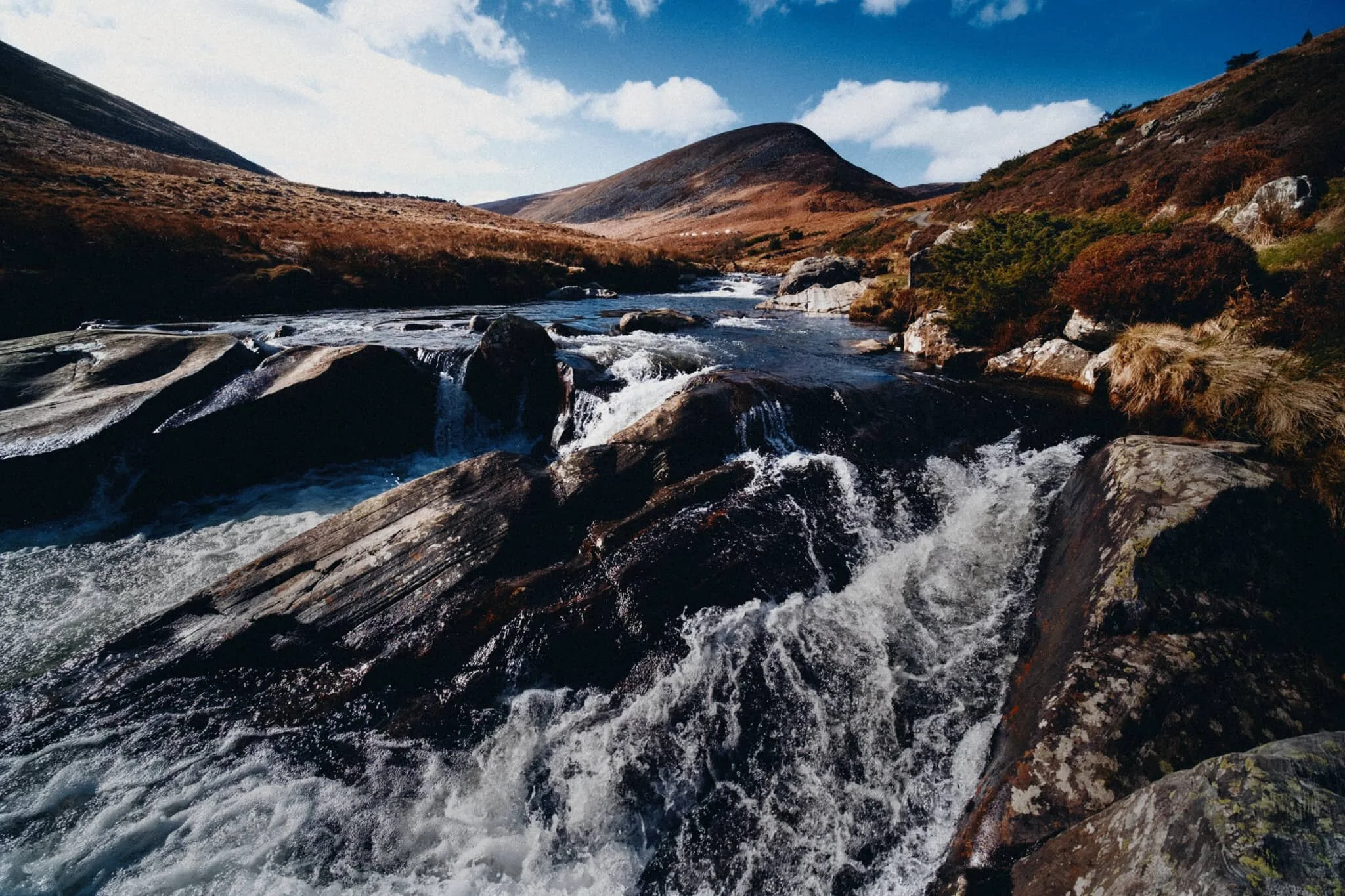
As the valley pinches tighter the track runs right alongside the river, allowing for compositions straight down the cascades towards Coomb Height.
We found a particularly powerful section of the river as it gets forced between several large boulders. I went scrambling into the river to line up some compositions featuring Coomb Height, the river, and the textures of these gorgeous boulders.
A bit more precariously close to the fast rapids but arguably a better shot as a result.
One of those moments where it feels great to be out in nature.
Here we’d reached the head of the Mosedale, where Grainsgill Beck and Blackhazel Beck meet. This is Grainsgill Beck, which cuts out a gill on the northern side of Coomb Height. The fell to the right is Milton Hill. Grainsgill Beck saw a lot of mining activity in the 19th and 20th century.
Lisabet went seeking for the perfection composition of a particularly powerful cascade on Grainsgill Beck.
Back at the foot of the valley is Mosedale village, which is rather idyllic and a true Cumbrian rural paradise.
Mosedale village is almost impossibly quaint, complete with a red phone booth and a GR-era post box.
The long back to the car, crossing Mosedale Common and entering Caldbeck Common. Lisabet pulling way ahead, leaving me and Dad flagging behind. She’s got a proper good stride on her.

Wasdale & Wastwater, Lake District: A Winter Series
There’s something special about the Western Lake District for me…
A famous Wasdale peak, Yewbarrow (628 m/2,060 ft), with the only road going in and out of the valley curling its way towards the fell’s foot.
There’s something special about the Western Lake District for me…
Because the area is naturally more difficult to access, on account of all the mountains, the Western Lakes tends to be more unfrequented whilst still containing some of the most epic scenery in all of the Lake District.
Lisabet and I took a short 1-week break at the beginning of February to recharge, after what turned out to be a somewhat hectic Christmas “break”. We stayed in a tiny little village south of Cockermouth town called Deanscales, and our home was a 17th-century converted farmer’s cottage, complete with stone floor, beamed ceilings, thick walls and more.
In most ways, it was the perfect place for us to recuperate.
Thankfully, the weather turned increasingly beneficial for us as the week progressed, and so one day we made our way towards the southwestern area of the Lake District, to what I consider to be my favourite place in England: Wasdale.
Wasdale hosts a few claims to fame: it features England’s deepest lake (Wastwater, 258 ft), England’s highest mountain (Scafell Pike, 978 m/3,209 ft), and possibly England’s smallest church (St. Olaf’s). The view from near the foot of Wastwater towards Wasdale Head was also once voted Britain’s Favourite View.
We took our time around this incredible place, visiting the powerful Ritson’s Force, the perfectly glaciated Mosedale, and of course checking out all of the views and compositions of Wasdale’s various fells and peaks.
Please enjoy this series of Wasdale and Wastwater in the winter. I hope my love of this place is conveyed in these photographs.
Feel free to tap/click on each image for a bigger view, and to download any for personal use as a desktop/phone wallpaper.
All photos taken on my Fujifilm X-T2 with a Fujinon XC16–50mm f/3.5–5.6 OIS lens. Editing and colour grading all my own.
The iconic pyramidal peak of Great Gable (899 m/2,949 ft), from near Lingmell House.
The Wasdale Head Inn, formerly the Wastwater Hotel, which has served travellers for over 200 years. The Pillar range of fells loom above.
Ritson’s Force, named after the Wasdale Head Inn’s most famous historical landlord, Will Ritson. The falls were very much in spate, their sound thunderous and their colour a wonderful hue of aquamarine.
The upper part of Ritson’s Force, which begins life in the crag wall of Pillar above Mosedale. “Force” comes from the Old Norse foss, meaning “waterfall”.
Looking down from the upper section of Ritson’s Force. I really wanted to capture the water’s incredibly clarity and colour, as well as its power as the falls cut through the gill.
A shot of the light emerging from the overcast sky, which hit the slopes of Lingmell as we climbed back out of the gill containing Ritson’s Force. I tried to use the trees as a framing device.
My wonderful Lisabet, looking tiny in the face of Pillar’s (892 m/2,927 ft) sheer southern wall. A small band of light escaped from the clouds behind us to hit the wall.
Making our up the side of the Mosedale valley, with the hulking crags of Red Pike (826 m/2,710 ft) in front of us. Another beam of light from the clouds behind us scans down the crags.
The full view of Lingmell (807 m/2,648 ft) from high up the side of Mosedale. The Scafell peaks, though much taller, sit behind Lingmell and were cloaked in cloud.
Zooming in from Mosedale to shoot some of that gorgeous light escaping the clouds and hitting the slopes of Lingmell and Scafell. I also loved framing the shot with all these diagonal lines crossing up and down.
The full extent of the peaceful Mosedale valley, looking towards the crag wall of Pillar. Mosedale is a tributary valley that branches off the main Wasdale valley, and is a beautiful example of a smooth glaciated valley.
Great Gable (left) and Great End (right, 910 m/2,990 ft) catching some of the brief light shows above Wasdale.
The View that was once voted Britain’s Favourite View, shot from roughly halfway along Wastwater’s northwestern shore, with my little Lisabet exploring the waters.
The Wastwater Screes is a sheer wall of crag that plunges straight into the dark lake of Wastwater. An awe-inspiring sight, no matter when you see them.
As the sun started to set, more light escaped from underneath the cloud shelf and a beam scraped along the face of Buckbarrow (423 m/1,388 ft) as we neared our car. Wasdale still hosts these Victorian-era sign posts that I find so endearing.
Looking back at the old sign post as another beam of light hits one of the many crags that surround Wastwater.
I’d be delighted if you were to share this page of these photos on your favourite social media/website of choice.