
Hodbarrow Nature Reserve, Cumbria, Autumn
Time for somewhere a little different.
Time for somewhere a little different.
For a little while now we’ve had our peripheral vision on a little-known nature reserve in southwest Cumbria: Hodbarrow Nature Reserve.
Today was the day to visit and explore it.
The nature reserve occupies the site of a former iron ore mine, which was in operation until the 1960s. The RSPB purchased the nature reserve in 1986, and are managing the area to sustain numbers of terns, wintering red-breasted mergansers, as well as wintering teals, coots, little grebes, redshanks and dunlins, and breeding great crested grebes. They are also looking to re-establish the nationally rare natterjack toad.
While parts of eastern Cumbria and North Yorkshire were looking cloudy and rainy, the southwest Cumbrian coast at Millom was thankfully sunny and clear, with gorgeous painterly high-altitude clouds aiding our photos.
Photos taken on my Fujifilm X-T2 using my Vivitar “Series 1” 28–105mm f2.8–3.8 zoom and Laowa 9mm f2.8 prime lenses. Images are 90% made in-camera using Shark & Palm’s “Kodak Ektar 100” film recipe. Finalised using Affinity Photo 2 for iPad.
Hodbarrow Nature Reserve, Cumbria, Autumn by Ian Cylkowski is licensed under CC BY-NC-SA 4.0![]()
![]()
![]()
![]()
What became immediately obvious to me and Lisabet upon our arrival was how quiet the nature reserve was. Absolutely delightful.
Beautiful “brush stroke” clouds decorated the skies above the flooded “lagoon” of the nature reserve.
The fell that commands your attention all around the nature reserve is Black Combe, an isolated Lake District fell of 600m high.
However, further into the distance are the Coniston fells, looking sublime as the clouds cast painterly shadows across the slopes of the fells.
An old abandoned lighthouse, possibly abandoned in favour of the newer one further southeast of the nature reserve. The little stub of a building in the distance to the right is the ruins of a windmill. The old windmill was used by Hodbarrow Iron Ore Mine to store gunpowder, used for blasting, between 1855 and 1880, when a purpose-built facility was built.
A clearer panorama of the Coniston fells.
A crackin’ composition I couldn’t resist. The old lighthouse reflected in the lagoon with the hump of Black Combe in the distance.
The crags of Hodbarrow Point, subject to constant erosion by the tides of the Duddon Estuary, itself connected to Morecambe Bay.
Beautiful strokes of painterly clouds adorn the skies above Black Combe. Attached to the nature reserve’s lagoon is the Hodbarrow Marina.
An old couple enjoy the views across the Duddon Estuary as feathery clouds streak across the sky.
As we approached the newer lighthouse, I noticed lots of large puddles nearby the enticed me to try my hand at a reflection composition. Not bad.
The “lagoon” of the nature reserve is protected from the sea by this beautiful sea wall, built in 1905.
Faded grandeur. Plus the streaky clouds enabled an ultra-wide composition as they “pointed” towards the lighthouse.
From the top of the sea wall, the ever-stretching expanse of Haverigg beach comes into view.
Looking along the sea wall all the way back to the Furness peninsula.
A simple scene, but beautiful nonetheless.
I enjoy the way the curve of the lagoon is mirrored in the curves of the clouds above.
After lunch, we re-emerged into the nature reserve with considerably more cloud cover. The Lakeland fells, however, were still looking magnificent.
The clouds grew larger and tighter around the sun. That would be it for the day.
Did you enjoy these photos?

Brockholes Nature Reserve, Lancashire, Winter
Recently I had the joy and honour of staying over at my best friend’s place in Preston, Lancashire.
Recently I had the joy and honour of staying over at my best friend’s place in Preston, Lancashire.
I lived in Preston for many years, leaving in 2012 to move further up north in Kendal, Cumbria. As such, it’s been a decade since I’ve seen Preston. The city has changed a lot.
Well, let’s be accurate. Some parts of the city, around the thriving University of Central Lancashire, have changed dramatically as the University continues to steer the economic direction of the city. Other parts of the city, away from the University, have barely changed or—worse—have totally degraded.
Both scenarios were a shock to see.
To cap off a lovely weekend, my friend and I had a wee waltz around the Brockholes Nature Reserve, located on the eastern outskirts of Preston. The Nature Reserve is situated in the flood plains of the River Ribble, and features the UK’s first floating visitor centre. The weather was pretty terrible all weekend, but thankfully during our hike it brightened up enough to actually snap some photos, in between the furious downpours.
All photos shot on my Fujifilm X-T2 using my Fujinon 23mm f/2.0 and Laowa 9mm f/2.8 prime lenses. Developed in Lightroom and finished in Affinity Photo.
As we left the car park to walk the 3-mile “Discovery” trail around Brockholes, the clouds above did not promise settled conditions.
Thankfully, the unsettled conditions resulted in this wonderfully clear double rainbow arching over the ponds.
Nearing the floating visitor village the sun broke out behind us, illuminating the landscape whilst another dark squall approaches overhead.
The floating visitor village was designed by Adam Khan Architects, built by Price & Myers, and opened to the public in 2011. It houses shops, an exhibition area, an activity room for schools and community groups, a restaurant and a conference centre.
After knocking back an espresso with a flapjack, it was time for one last prowl around this magnificent feat of architecture.

Whitbarrow, Lake District, Summer
It was time to continue exploring a “local” fell.
It was time to continue exploring a “local” fell.
The first time Lisabet and I checked out Whitbarrow was only a few months ago, March in fact. Considering it’s just a few miles west of Kendal, it’s incredible that we’d never hiked up the fell in all our time living round here.
Our spring hike gave us a nice little introduction to the potential of Whitbarrow. Now we’re in the summer, we ventured up once again with a slightly different—and longer—route.
In particular, after summiting Lord’s Seat we took the trail through the Nature Reserve part of Whitbarrow to find a landscape more akin to a tropical jungle!
All photos shot on my Fujifilm X-T2 using two of my prime lenses: a Samyang 35mm f/1.2 and an adapted Pentax SMC 55mm f/2.0. Images made 75% in-camera using a customised Classic Chrome film simulation, with some finishing edits afterwards in Snapseed and Affinity Photo.
The area around Whitbarrow seems to be a veritable treasure trove for wild food foragers! Near where we parked, we found a hedge full of sloe or blackthorn, Prunus spinosa. Anyone fancy making some sloe gin?
The hike up and through the Township Plantation to get onto the fell gave us an indication of how fecund Whitbarrow was in comparison to March. Ferns everywhere.
Despite only being the first day of August, some of the abundant fern was already changing into its autumn colours.
A silver birch surrounded by multi-hued fern caught my eye as we approached the open limestone fellside of Whitbarrow.
The soft transition of light between the highlighted ferns and tree trunks compared to the gloom of the inner woodland.
Pretty purple heather is starting to blossom. A sure sign that late summer is coming.
We exited the Township Plantation and followed the trail east up onto the open fell.
Looking back at the woodland we navigated through to get onto the open fellside.
This is where you start to see some fantastic limestone formations and glacial erratics ahoy. My lovely Lisabet providing a sense of scale here. In the distance, a little to the right, you can just make out the unmistakeable shape of Ingleborough in the Yorkshire Dales.
Young cows up on the fell didn’t want to give me and my camera too much attention.
The wonderful contortions of the common juniper, Juniperus communis.
I followed Lisabet on a trail northwards, to see how the views opened up towards the Lake District fells. The clarity was rather lovely.
Lisabet checking out some of the more shapely trees around the northern edge of Whitbarrow. Additionally, a view of the Langdale Pikes could clearly be made out.
We retraced our steps and picked out a trail heading south towards the Flodder Allotment part of Whitbarrow. The path took us through a silver birch plantation near Horse Pasture Wood.
This is the way to the summit of Whitbarrow, known as Lord’s Seat. There were plenty of other hikers around the fell, though certainly not enough to make the area feel busy.
As we gain height the views of the surrounding fells open up. A young family play around the limestone escarpment that forms a natural boundary for the Nature Reserve. In the hazy distance lies the Howgills.
Approaching the wind-blasted summit and cairn of Lord’s Seat, which also serves as a signal to take a rest for water and a snack.
The view south from Lord’s Seat. Rather lovely isn’t it? To the right is the coastal village of Arnside with Arnside Knott above it, and in the far distance is the edge of the Yorkshire Dales.
We closed in on the limestone wall that serves as a natural perimeter of the Whitbarrow Nature Reserve. I couldn’t resist these curving shapes offered by a pair of juniper trees set against the escarpment.
There are plenty of trees that grow out of the limestone wall, which then get blasted by the wind, resulting in remarkable scenes like this.
We finally found the trail that heads into the Whitbarrow Nature Reserve and took it northwards to eventually rejoin our original path. I’ve never seen a place like it! Very much like a jungle.
As we neared the Township Plantation once again, the Nature Reserve opened up and we found this beautiful world of limestone columns, stunted trees, and the floor carpeted in flowers. Like a lost world.
Two pillars of limestone, putting me in mind of a bee hive or something. Incredible.
Roudsea Wood & Mosses, Cumbria, Spring
Time for somewhere a little different.
Time for somewhere a little different.
Cumbria being what it is, a sparsely-populated county full of nature, there’s a fair few Nature Reserves never mind the actual Lake District National Park. We’ve explored a few of them previously, for example Foulshaw Moss and Watchtree. This time we ventured south of Windermere and Newby Bridge, beyond the pretty village of Haverthwaite.
This is Roudsea Wood & Mosses Nature Reserve.
The Reserve is located on the eastern side of the Levens Estuary, west of Cartmel. Roudsea Wood is one of Britain’s most important woodland sites, combining varied geology (limestone and slate) with alluvial soils and fens. This has created a woodland full of bio- and geodiversity. Just east of the woods are the bogs of Roudsea Moss, an important area of peat and wildlife, especially Ospreys.
Further west of the Nature Reserve one can hike the Cumbria Coast Way towards the Levens Estuary itself, an extension of the humongous mudflats and sands of Morecambe Bay.
Roudsea: a place of bog, woodland, and sea.
Definitely one for Lisabet and I to keep coming back to.
All photos shot on my Fujifilm X-T2 using my three prime lenses: a Samyang 35mm f/1.2, a Laowa 9mm f/2.8, and an adapted Pentax SMC 55mm f/2.0. Developed using RNI’s Kodachrome film profiles.
Around Roudsea Mosses, the bogs are home to isolated clusters of Scots Pines, making for rather minimalist compositions.
Pleasing to the eye, especially the sense of distance.
The bogs of Roudsea Moss are thankfully easy to navigate courtesy of these boardwalks. They also enable compositions by offering a leading line.
Back into the woods we go.
Delightful tree textures to photograph.
Upon entering the Woodland Trail the geography quickly changes from open bog to a limestone woodland. Lisabet and I spotted this otherworldly scene consisting of tree branches snaking around a limestone outcrop.
There were barely any clouds on our outing, allowing for the sun to penetrate through the canopy of the woodland.
More snake-like tree trunks and branches, with the addition of fungi, which Lisabet was happy to find.
This part of Roudsea Woods was a lot more green, and we were happy to see the beginnings of bluebells appearing on the woodland floor.
Just a moment, when the light caught only this tree.
Flora blossoming everywhere.
An early Bluebell. We’ll be seeing more of these in the various woods around Cumbria within the next fortnight or so.
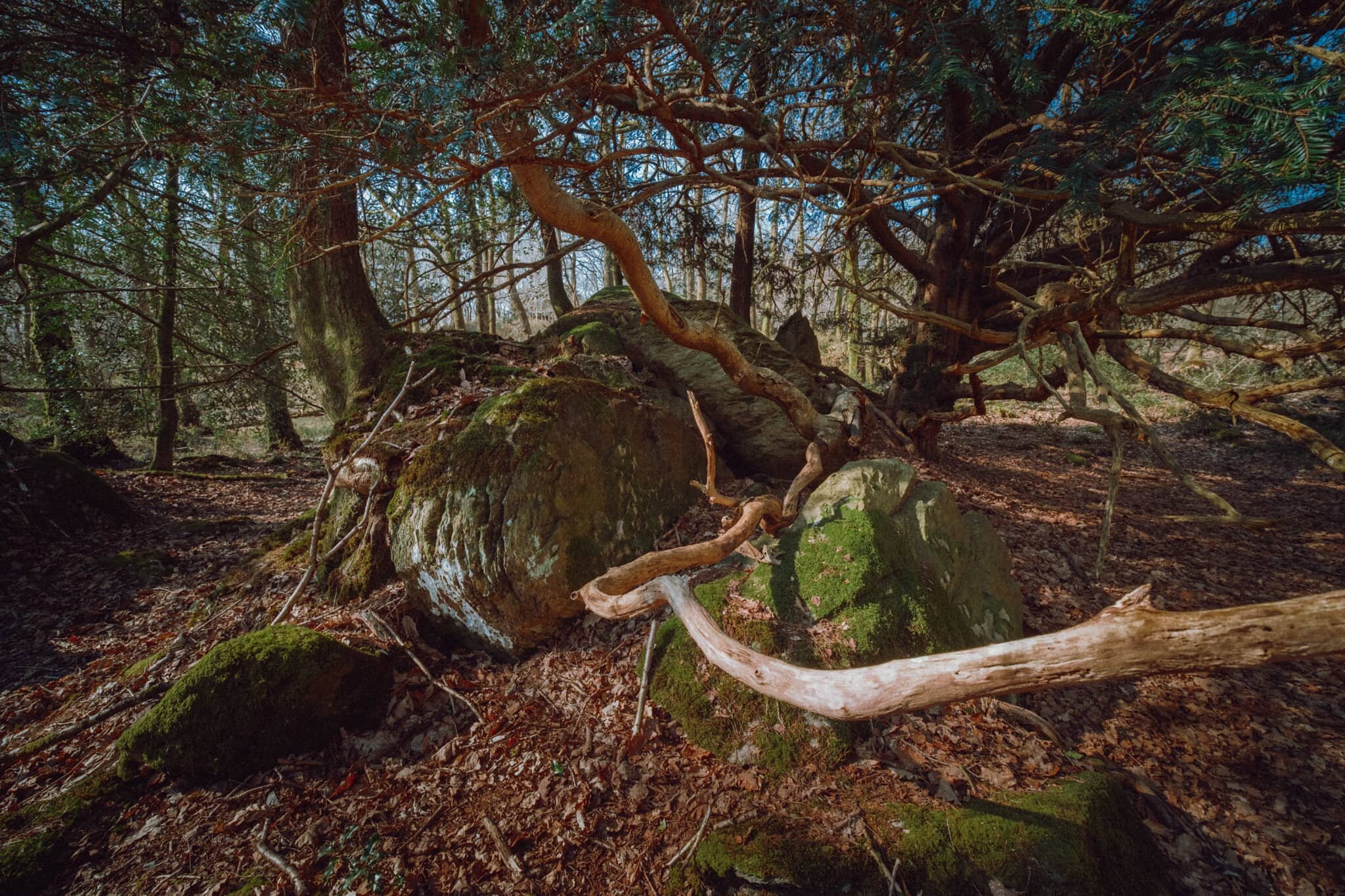
A weird configuration of a limestone outcrop with a tree root system slowly enveloping it.
Tendrils of wood everywhere, gorgeous textures abound.
After completing the Woodland Trail, we joined the Cumbria Coast Way west towards the Levens Estuary. I knew there would be sand and mudflats ahoy as the estuary is linked to Morecambe Baby, but I had no idea there were these rocky outcrops along the coast.
I was transfixed when I saw these rocks and their beautiful lines, textures, and patterns. I had to come get some compositions in.
We were blessed with a rather beautiful, if hazy, day to be exploring this area of South Cumbria.
Looking back across Levens Estuary towards How Barrow and the Cartmel fells.
An almost impossibly perfect composition that I couldn’t resist on our way back to the car.
Pandemic Peregrinations: Whitbarrow, Cumbria, Spring
I’ve often gazed longingly at Whitbarrow Scar from afar.
I’ve often gazed longingly at Whitbarrow Scar from afar.
Finally we decided to clamber around it.
Whitbarrow (215m/705ft) is a limestone hill, much like its neighbour Scout Scar, with whom I’m much more familiar with. Whitbarrow is further west of Scout Scar across the Lyth Valley, but covers a much larger area. When viewed from the A590 south of the fell, Whitbarrow presents some sheer and imposing cliff faces that I instantly fell in love the first time I saw them. I resolved to one day wander around the contours of Whitbarrow. Today was that day.
Whitbarrow is definitely not as easy to access as Scout Scar. Whereas Scout Scar can be reached with ease from the tiny car park near its northern edge (or walked to directly from Kendal), Whitbarrow has no official car park nearby and is surrounded only by tiny villages and hamlets. We elected to park in one of the laybys off the A5074, then walk into the village of The Row to find the footpaths up onto Whitbarrow.
We spent a good 2-3 hours around Whitbarrow and quickly got the distinct impression that this was a fell that we could return to time and time again, and still not see all of that. The fell is quite vast and varied. Its western flank drops down steeply to the valley floor at Whitbarrow Scar, but does so more smoothly compared to Scout Scar’s vertical cliffs. The eastern part of Whitbarrow is a protected Nature Reserve, featuring limestone shelves, limestone pavements full of clints and grikes, and lots of woodland.
We managed to summit the fell at Lord’s Seat and made a small loop back towards The Row. There is still a lot to more explore of Whitbarrow, and I look forward to returning again.
All photos shot on my Fujifilm X-T2 using my three prime lenses: a Samyang 35mm f/1.2, a Laowa 9mm f/2.8, and a converted Pentax SMC 55mm f/2.0. Developed using RNI’s Kodachrome film profiles.
As we started to ascend out of The Row, the views across the Lyth Valley towards the Far Eastern Lake District fells quickly opened up. We were blessed with another lovely day of weather.
There is considerably more woodland on and around Whitbarrow compared to Scout Scar.
From the woodland near The Row known as the Township Plantation, we branched off west towards the cliffs of Whitbarrow Scar. We wanted to see what the views towards the Lake District fells were like.
The way forward, with some runners up ahead. The sky was a lot more dramatic today, but still thankfully dry.
Now that’s a view. The Langdale Pikes towards the right, Wetherlam and the Coniston fells towards the left. Dappled light everywhere. Glorious scenes.
The cliffs north of Whitbarrow Scar with the Eastern Lake District fells in the distance.
Just amazing views of the Kentmere and Longsleddale fells.
Near Bell Rake the land drops away sharply, exposing these silver birch to the consistent westerly winds.
One of many glacial erratics around Whitbarrow, physical testament to the fell’s ice age history.
After summiting at Lord’s Seat we followed the “spine” south from the summit, taking in the views towards Morecambe Bay along the way.
Getting closer to the precipitous drop of Whitbarrow Scar.
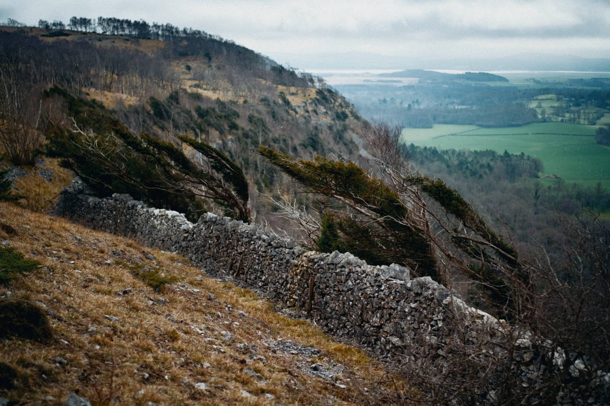
A wall prevents you from getting near the edge, lest you tumble towards the valley floor. Wind-blasted trees give an indication of what the conditions can be like on the fell.
More wind-blasted silver birch with moody skies.
Just one example of the almost impossibly perfect wall-like structure of the limestone pavements found near the Whitbarrow Nature Reserve.
Whitbarrow Nature Reserve is a limestone woodland, featuring all manner of flora that survives in the acidic soil conditions and changeable weather.
My ultra-wide 9mm lens had some fun following various tree trunks and branches for more unusual compositions.
We found this weird tree that appeared to have a separate tentacle-like trunk growing out of it. I got close and low with my 9mm lens to follow the line of this trunk.
A rather unusual tree, to my experience; the trunk is almost tendon-like in its structure. Google thinks this is Hesperocyparis macrocarpa, a Monterey cypress tree.
The way back to The Row through the Township Plantation. We’ll be back, Whitbarrow…