
Grisedale, Lake District, Winter
Happy New Year, everyone! Here’s to a peaceful and gentler 2024.
Happy New Year, everyone! Here’s to a more peaceful and gentle 2024.
Though I’ve enjoyed time off work between Christmas and New Year, it’s not exactly been pleasant. Storm Gerrit washed across the UK, rendering most days miserably wet. There were even tornado warnings, largely unheard of in the UK.
On New Year’s Eve we learned that New Year’s Day promised much nicer conditions, and so we endeavoured to rise early and head into the Lake District for a solid yomp on the first day of 2024.
Conditions were certainly nicer, though you can never predict weather in the Lake District 100%. Hiking along the valley bottom of Grisedale towards the valley’s head, we were washed with wave after wave of fine drizzle. Thankfully, it never rained that hard, and in between the downpours we still managed to nab some glorious photos.
All photos taken on my Sony α7ii using my Pentax SMC 28mm F3.5 and Pentax SMC 55mm f2.0 prime lenses. RAWs developed in Lightroom using RNI Films’ Kodachrome film profiles, finalised in Photoshop.
Grisedale, Lake District, Winter by Ian Cylkowski is licensed under CC BY-NC-SA 4.0![]()
![]()
![]()
![]()
A sign of things to come. St. Sunday Crag (841 m/2,759 ft), rising above a sodden landscape with stormy clouds above.

Much of the first half of hiking into the valley comprised of dodging waves of drizzle. When one cleared up for long enough, I snuck this shot of Eagle Crag and Dollywaggon Pike (858 m/2,815 ft) battling with the low clouds.
Arriving closer to the turning point, we contemplated the condition of the trail on the other side of the valley. The hike in, on the south of the valley, is thankfully paved but had still been rendered in parts as a beck due to all the rain. I knew that the northern path back down the valley wasn’t in as good nick. So, from here, we turned back the same way we came in.
Thankfully, this was also when conditions started to clear up and the Helvellyn range of fells began to reveal themselves.
Eagle Crag with Nethermostcove Beck roaring down the fellside. A project was started in 2021 to return the valley’s main river, Grisedale Beck, back to its original “wiggly” form. To quote the Friends of the Ullswater Way: “As with many rivers in the UK, Grisedale Beck has historically been straightened and reinforced so that fields can be drained to improve grazing. This work was undertaken over 200 years ago and since then we have learned a lot about how straightened and reinforced rivers can negatively affect wildlife and increase flood risk. It should be noted that, despite the historic changes made to the river at the project site, this is still not particularly good grazing land, being very rough pasture and quite boggy in areas.”
Heading back down the valley, we kept turning back at the beautiful view at the head of Grisedale. Primarily to check on any incoming rain washing over the fells, but also to gawp at them. I enjoyed this composition as the trail seemingly leads across the image towards Nethermostcove Beck on the right. Pure mood.
One of the few pines left in the valley points a vibrant branch towards the beautifully cracked glacial erratic.
As the cloud cover finally starts to lift, Falcon Crag and Tarn Crag emerge from behind Dollywaggon Pike.
Light finally breaks through the clouds as we retreat further down the valley.
The beck streaming down from Blind Cove provides a nice leading line towards the vertical face of St. Sunday Crag.

The fells become obscured again. Another wave of rain heads towards us.
As another squall washes over us, I look across to the northern side of Grisedale and spot these bright becks cascading down the fellside. I very quickly nab a photo.
Soon, we near the foot of the valley and the rains were finally done for the afternoon. Look at that mountain backdrop.
Heading back towards the car, the hulking mound of Place Fell catches the warm winter light across its crags.
We elected for the scenic route back to Kendal, heading north out of Patterdale, through Matterdale, and onto the A65. That way we could turn off to head down St. John’s in the Vale and join the A591 back to Kendal. I kept my camera out, with the 55m attached to it, and grabbed this epic scene of Blencathra from the passenger’s side.
Down St. John’s in the Vale, I kept snapping happily, praying that at least one of the shots rendered sharp. Here, the deep cleft of Beckthorns Gill cuts into various crags of Clough Head.
Further south on the A591, near Thirlmere, Fisherplace Gill cuts a deep fissure within the crags of the Helvellyn massif. The farmhouses below look miniscule in comparison.
The distinctive shape of Browncove Crags, a subsidiary top of Helvellyn, with another deep gill caused by Helvellyn Gill.
Did you enjoy these photos?

Sedbergh, New Year's Day, Cumbria, Winter
Happy New Year everyone!
Happy New Year everyone!
I hope you all had a merry time with those you love (which can also just be yourself). What are your goals for 2023? Let’s hope this year’s a little more… boring, shall we say?
To kick of 2023, Lisabet and I ventured east to Sedbergh. It’s been raining a lot in December, but we were hoping there’d be a teeny little break in the rain around lunchtime. And, incidentally, we had a table booked at the gorgeous Dalesman Country Inn for a New Year’s Sunday Roast.
We picked a trail that ran past the famous Sedbergh School, and down towards the River Rawthey. Here you join the Dales High Way and head east, past the Pepperpot and the ruins of Akay House, all the way to the New Bridge and back into Sedbergh, ready for a Sunday Roast.
Ultimately, we still got wet. But I did manage to get a few decent shots.
All photos taken on my Fujifilm X-T2 using my Vivitar “Series 1” 28‒105mm f2.8‒3.8 zoom lens. RAWs developed in Capture One for iPad, then tweaked and finished in Pixelmator Photo for iPad and Affinity Photo 2 for iPad.
Sedbergh, New Year's Day, Cumbria, Winter by Ian Cylkowski is licensed under CC BY-NC-SA 4.0![]()
![]()
![]()
![]()
Sedbergh’s full of these beautiful little yards and alleys that are always so photogenic.
Plenty of Sedbergh’s yards are still cobbled, too. In the distance you can just make out the now-rusty hues of the southern Howgills.
The graveyard of St. Andrew’s Church as you head towards the grounds of Sedbergh School. The present church dates from around 1500AD, but material from earlier churches here have been incorporated into the current building.
Over towards Baugh Fell (678 m/2,224 ft), the heavens opened and dumped their liquid shipment all over the fell.
Just up the river bank along the Dales High Way is the Pepperpot. The story of its origin has been lost in the mists of time. One legend states that it was constructed as an isolation house for a local land owner’s daughter who had Tuberculosis. The ruins of this building were reconstructed in 2019 and the building has been given to the local community.
As the Pepperpot is perched on an isolated drumlin, it enjoys lovely views around Sedbergh. I enjoyed the way the trees and drystone walls created wandering lines across the frame all the way up to Holme Fell on the left.
A vertical photo of the same compositional idea.
Across the valley towards the Howgills, Arant Haw catches a little bit of afternoon winter light.
Into Akay Woods, a piece of mosaic flooring and a couple of these stone archways are all that remains of Akay House.
Before the heavens opened up again, I managed to sneak a clear view of the Howgills from the Rawthey footpath. The members of the Howgills seen here, from left to right, are Crook (461m/1,513ft), Sickers Fell (498m/1,633ft), and Knott (429m/1,407ft).
After all the rain we’ve had, the River Rawthey was absolutely gushing with water. At the weir near New Bridge, the curves of the weir and the water caught my eye and I lined up a composition. Turned out quite nice!
Paused at New Bridge to snap these mossy branches above a raging River Rawthey.
Did you enjoy these photos?
Scout Scar, New Year’s Day, Lake District, Winter
Happy New Year everyone! Here’s to a joyous and—hopefully—more globally positive 2022.
Happy New Year everyone! Here’s to a joyous and—hopefully—more globally positive 2022.
The weather has been… weird. In fact, the UK set a new temperature record for New Year’s Eve, reaching as high as 16.5ºC. That is uncharacteristically warm. Temperatures maintained their elevated levels on New Year’s Day, too, but high winds also arrived. After a decent lie in, Lisabet and I decided on a local favourite to enjoy the first day of the new year: Scout Scar.
The last time we went up Scout Scar was almost exactly a month ago, and conditions could not have been more different. For New Year’s Day we took the time-honoured route up Captain French Lane and onto Brigsteer Road, following that all the way to the back of Scout Scar. Then, it’s a simple exercise of following the trail up the gentle slope of Scout Scar all the way until you reach it’s precipitous drop down to the Lyth Valley.
The wind was roaring all around us and views were obscured by haze and low cloud covering the Lake District fells. However, the sun was trying its hardest to burst out in between the rushing clouds. There were other sounds that were less familiar as we approached the summit… more rhythmical, and human. Turns out that Drum Nation Kendal had arrived at the summit for a joyous New Year’s Day drum performance on the fell.
Unexpected? Absolutely. But very awesome.
All photos taken on my Fujifilm X-T2 using two of my prime lenses: a Fujinon 23mm f/2.0 and an adapted Pentax SMC 55mm f/2.0. All images made in-camera using a customised Classic Chrome recipe, with finalisations made in Apple Photos, Pixelmator, and Darkroom.
Heading up one of the steeper roads in Kendal, Captain French Lane.
Crossing over the A591 via Brigsteer Road, cars struggling to drive straight in the powerful crosswinds.
Looking back to Kendal, and you barely make out the slopes of Benson Knott, Kendal’s most prominent fell.
The Scout Scar landscape is one of limestone and sparse clusters of small trees.
Plenty of other folk were heading up Scout Scar for a New Year’s Day yomp, despite the roaring wind.
As we crested onto the plateau of Scout Scar, it became clear there was an immense light show occurring over the Lyth Valley and the Kent Estuary.
My lovely Lisabet, fighting the storm near the cliff edge at Hodgson’s Leap to nab some crackin’ light.
The swirling clouds, full of moisture, suffused the sunlight, and drenched the winter limestone landscape in golden light.
Away from the sun, the view north along Hodgson’s Leap to the “mushroom” on the summit of Scout Scar is always a good ‘un.
The sun catches the cliffs of Scout Scar briefly, whilst the Lyth Valley and the the Lakeland Fells remain shrouded in dark foreboding clouds.
We work our way north along the cliffs of Scout Scar, taking in whatever views we could find, and generally enjoying the dramatic conditions.
It’s a long way down…
A reminder of what was happening behind us. A lot of the Lyth Valley was still flooded after recent downpours.
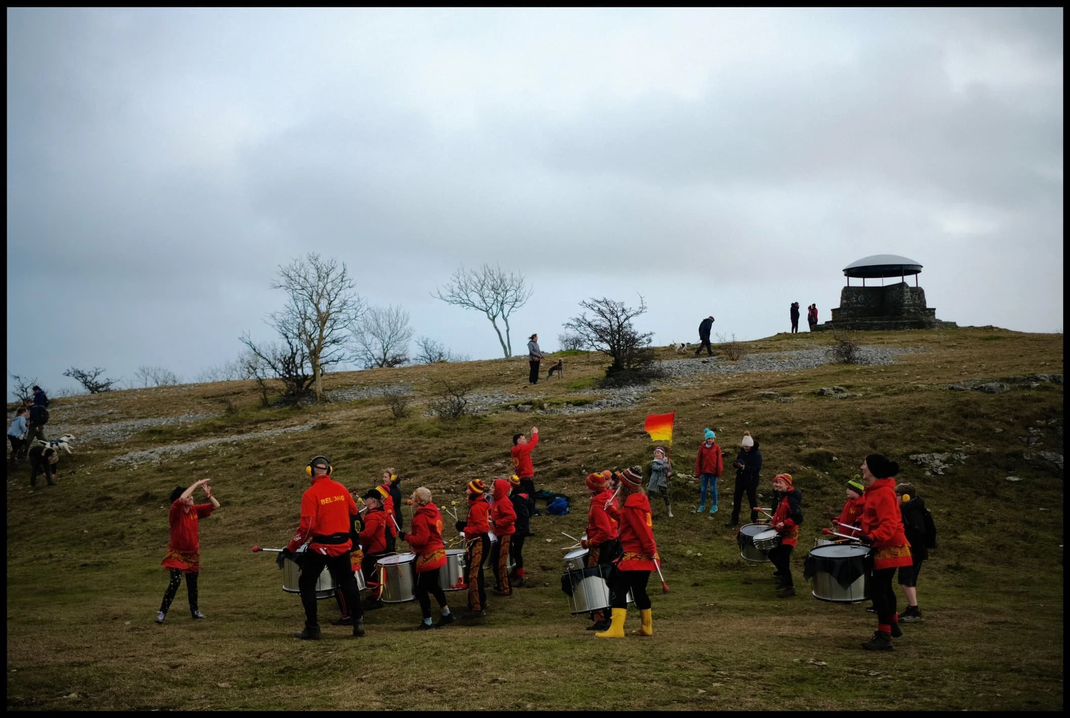
Our ears prick up at a more unfamiliar sound near the Scout Scar summit. Was that… drumming?
Why yes, yes it is!
Drum Nation Kendal, the epitome of fun, competing with the wind on volume.
Everyone was having so much fun.
Gathering round for the finale.
One last look at the spectacular light show over the Lyth Valley and Kent Estuary.
The legacy of Postman Pat in Kendal. Did you know?