
Brough Castle, Cumbria, Spring
My shoulder’s starting to feel well enough for some more energetic and long-distance hikes.
My shoulder’s starting to feel well enough for some more energetic and long distance hikes.
With the weather forecast finally looking nice for the weekend, we spent Saturday with my Dad and took him to the historic village of Brough in Cumbria. Here one can find the impressive ruins of the 11th century Brough Castle.
The castle was built on the site of an older Roman fortification, called Verterae. The fort was in use until the 5th century. After William the Conqueror’s subjugation of England in 1066, his son—William Rufus—built Brough Castle in 1092 on top of the old Roman fort after successfully invading Northern England. The site of the old fort and castle overlooks Stainmore Pass and the River Eden, an important strategic stronghold.
Over the ensuing centuries, Northern England became a battle ground between the Kings of Scotland and England. In time, Brough Castle came into the hands of Clifford family. In particular, Lady Anne Clifford completely restored the castle in the 17th century, alongside a number of other properties within her vast estate. A fire broke out in 1666, gutting the castle. It fell into decline shortly afterwards, intermittently being stripped of stone for other constructions.
Brough Castle is now managed by English Heritage, who look after the ruins. We enjoyed a wander around these historical ruins, followed by a brief jaunt further along the Pennine Bridleway. Unfortunately, after February’s storms, most of this part of the bridleway was boggy and thick with greasy mud. We bailed on this occasion and resolved to do the hike again during drier conditions.
All photos taken on my Fujifilm X-T2 using my three prime lenses: a Fujinon 23mm f/2.0, a Laowa 9mm f/2.8, and an adapted Pentax SMC 55mm f/2.0. Images developed using RNI Films’ Fortia SP film profile.
The route to Brough Castle enjoys spectacular clear views towards the Northern Pennines. No wonder this area has been used to build fortifications for so long.
And there she is. This is the southeastern profile of the castle, showing Clifford’s Tower and its 17th-century windows.
A young family ahead of us excitedly entered the grounds.
Once in the grounds of the ruins, it was time to don my ultra-wide lens for some vast compositions of the castle.
This composition was shot underneath the 12th-century arch, with a view towards the 17th-century Keep in the distance. A mind-boggling sense of time and history.

These hall ranges were last modified in the 14th-century. To the right, high up, is the high wall of the gatehouse.
At the other end of the site, we approached the imposing Keep. It was last modified by Lady Anne Clifford in the 17th-century, and she lived in it for a period during 1665.
The Keep, originally built in the 12th-century, enjoys excellent panoramic views to the River Eden.
The Gatehouse and ranges from the Keep. I don’t know why, but this photo puts me in mind of Machu Picchu.
In the neighbouring fields, horses graze peacefully. In the distance, the flat-topped Wild Boar Fell in Mallerstang can be made out.
What magnificent structures. Their remains tell a story 1,000-years old.
I made one more ultra-wide composition of the inner and outer ranges as the light was so good.
After exiting the ruins, we located the Pennine Bridleway and followed the trail west towards the River Eden.
The views quickly open up and we are afforded lovely scenes looking back at the ruins of Brough Castle.
Looking south across the fields to the Mallerstang valley, flanked by Wild Boar Fell and Mallerstang Edge.
Though the day was sunny and clear, there was a strong and bitingly cold wind. This meant the sun made intermittent appearances, variously scanning across the land in many patterns. Upon spotting this composition, I lined everything up and simply waited for the sun to break free of the clouds again to highlight the castle ruins.
It’s easy to see why there’s been a fort of some kind here since the Ancient Roman times.
The fields will soon fill up lambs once again.
Spring is on her way.
North Pennines Waterfalls, County Durham, Summer
Woohoo for a week off! With the Lake District as rammed as it is at the moment, let’s go somewhere a l’al bit different.
Woohoo for a week off! With the Lake District as rammed as it is at the moment, let’s go somewhere and l’al bit different.
The North Pennines AONB (Area of Outstanding Natural Beauty) is a favourite of ours but remains relatively untouched by us. We’ve explored arguably the jewel of the North Pennines, High Cup Nick, many times. But another absolutely stunning part of the area is the three main waterfalls: High Force, Low Force, and Cauldron Snout.
Long-time followers of this blog may remember our last excursion to High Force and Low Force, last year. The two waterfalls are a geology student’s dream and truly spectacular. But the third waterfall, Cauldron Snout, is often missed out on compared to the other two. That’s because it’s many miles further up the River Tees, near Cow Green Reservoir. Like High Force and Low Force, Cauldron Snout is the result of the outflow of Cow Green Reservoir passing over the whin sill; a layer of prehistoric super-hard dolerite volcanic rock that has left pillars and columns. The waterfall has eroded the softer rock around, leaving the harder columns of whin sill standing.
Cauldron Snout “only” drops about 60 m, all in all, but does so steeply down 180 m of the gorge, making it one of the longest waterfalls in England. The last time we visited it was many years ago in between Christmas and New Year, and a lot of the rock around the waterfall was covered in ice, making it a treacherous task to navigate. This time, we managed to scramble all the down alongside the waterfall. It was immense.
All photos shot on my Fujifilm X-T2 using my three prime lenses: a Samyang 35mm f/1.2, a Laowa 9mm f/2.8, and an adapted Pentax SMC 55mm f/2.0. Images developed using one of RNI Film’s Kodachrome profiles, finished in Affinity Photo.
Low Force is probably the easiest of the three to access, being less than a kilometre’s walk from the Bowlees Visitor Centre. Regardless, it’s an impressive sight and sound.
My lovely Lisabet, already on the case and getting some compositions in.
I clambered around the columns and cliffs of whin sill to get to the northern bank of the Tees for this view of the main falls of Low Force. The morning’s light was wonderful and I didn’t want to miss out.
The twin falls of Low Force. Not necessarily all that tall, but powerful and loud.
The conditions and light were beautiful. Not too harsh. Autumn’s definitely on the way.
One gentleman decided that a dip in the waterfall was in order.
Fair play to him.
The Pennine Way heads along this footbridge, which crosses the River Tees below. It’s an old ‘un, too, so all the signage requests people cross it one at a time.
The lower aspect of Low Force shot from the southern banks of the Tees after we crossed the bridge.
After I spotted this young lass climbing the statues, I think she looked rather… sheepish?
A tighter composition of the main falls of Low Force, trying to convey the sheer power of these waterfalls. The redness in the water comes from all the peat the river carries from the high moorlands of the North Pennines.
Looking back at the northern bank of the River Tees, with more people finding their now to the waterfalls. Best get a move on.
Lisabet doing her best to capture all the splendour around her.
Love all the signs of autumn starting to appear.
Looking forward to all the rusty colours of autumnal ferns.
After trekking the Pennine Way along the southern side of the River Tees, we crossed another old footbridge and took these steep steps up towards the road. A visit to High Force beckoned us.
The woodland above the Tees is still lush.
After paying our entrance fee (£2 per adult, very reasonable), we followed the path through the woodlands of the Raby Estate. Already, we could hear the booming sound of the giant waterfall, High Force.
The first glimpse of High Force and the gorge it’s created. The excitement builds…
And there she is, plunging 70 ft off a cliff into the deep pool below. What a sight.
We scrambled down to the boulder field left behind by the receding waterfall, each of us seeking our own photographic compositions of the waterfall.
Of course, mine predominately featured all the wonderful shapes of the boulders.
After thousands and thousands of years, as the waterfall carves its way back up the River Tees, it’s left behind boulder with fascinating shapes and textures.
Plenty of other folk were clambering around the boulders for better views of the awesome High Force.
Nature makes you feel closer.
Due to the COVID-19 Pandemic, the High Force trail is a one-way system now, so we hiked up the steep steps out of the gorge and navigated through the Raby Estate woods back to the car. My lovely Lisabet, looking as stunning as ever.
Upper Teesdale has a similar “feel” to a Yorkshire Dales valley, to me.
After a break for lunch, we drove a few miles west and parked at Cow Green Reservoir, seeking out Cauldron Snout. Along the way, views across the reservoir can be had of Meldon Hill (767 m/2,517 ft).
We crossed the dam for views over the reservoir and below to the Tees. Clouds of midges were out in full force.
Looking down onto the Tees from the top of the dam. You can just make out to the left the top of Cauldron Snout before it crashes down into the valley.
Cow Green Reservoir was constructed in the late 1960s to supply the industries of Teeside with a constant supply of water.
The reservoir essentially acts as a river regulator, ensuring the River Tees is always flowing with water even during dry conditions.
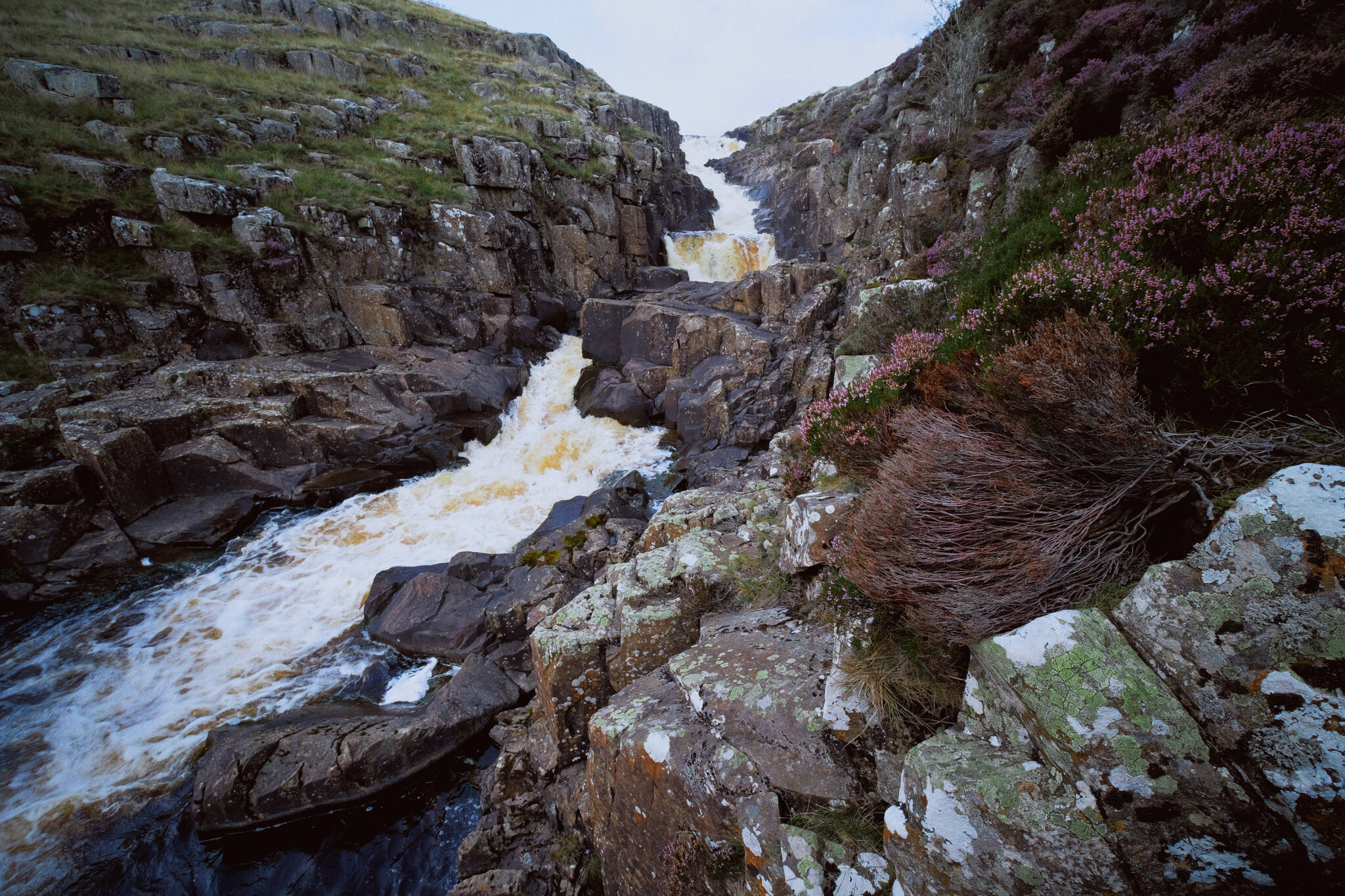
And here’s the top of Cauldron Snout. The Pennine Way is to left, but it isn’t really a “path” as such as navigating and scrambling down the side of the gorge created by the waterfall.
But doing so enables you to get right next to the falls for cracking views like this. A man perched at the top of the falls helps provide a sense of scale.
With the heather in bloom, they provided wonderful pops of colour around the waterfall.
Scrambling down the gorge was exhilarating, and definitely something that would not have been possible for my condition 5-years ago.
As the gorge sheltered us from the wind, this provided the necessary moist and still conditions for clouds of midges to form everywhere. They duly took advantage and started ravaging our bare flesh.
Near the bottom of Cauldron Snout now, and we can start to understand the scale of these falls.
The bottom of Cauldron Snout, which climaxes with this beautiful fanned curtain of a waterfall.

Teesdale Waterfalls, North Pennines, Autumn
On the final day of our mini-break we decided to enjoy a proper good hike around Upper Teesdale.
On the final day of our mini-break we decided to enjoy a proper good hike around Upper Teesdale.
We’ve been to Upper Teesdale a few times before, mostly for quick excursions to the epic High Force waterfall. But now we’re fitter and healthier, we felt capable of more, so we parked at the Bowlees Visitor Centre and took in lots of waterfalls around Upper Teesdale.
Upper Teesdale sits within Country Durham near the border with Cumbria, and is also entirely within the North Pennines Area Of Outstanding Natural Beauty (AONB). As well as enjoying the protections of being with in the AONB it’s also a SSSI (Site of Special Scientific Interest), for its diverse range of habitats and being one of the most important botanical areas in Britain; Upper Teesdale features a vast mixture of nationally rare flora, including some that are essentially relicts of the last glacial era.
As cool as all this is, Lisabet and I were here for waterfalls and vast open landscapes. Within a relatively small area we were able to visit Summerhill Force (in Gibson’s Cave), Low Force, High Force (from above), and Bleabeck Force. The area is a veritable treasure trove of watery delights!
All photos shot on a Fujifilm X-T2 with a Fujinon XF 18–55mm f/2.8–4.0 using a customised Classic Chrome film profile.
A few metres from the Bowlees car park we chanced upon our first waterfall, which we initially thought was Summerhill Force itself. A pleasant little drop.
After trekking back to the Visitor Centre, then across the road and down into the woods, the canopy opens up and we are treated to the spectacular site of Low Force.
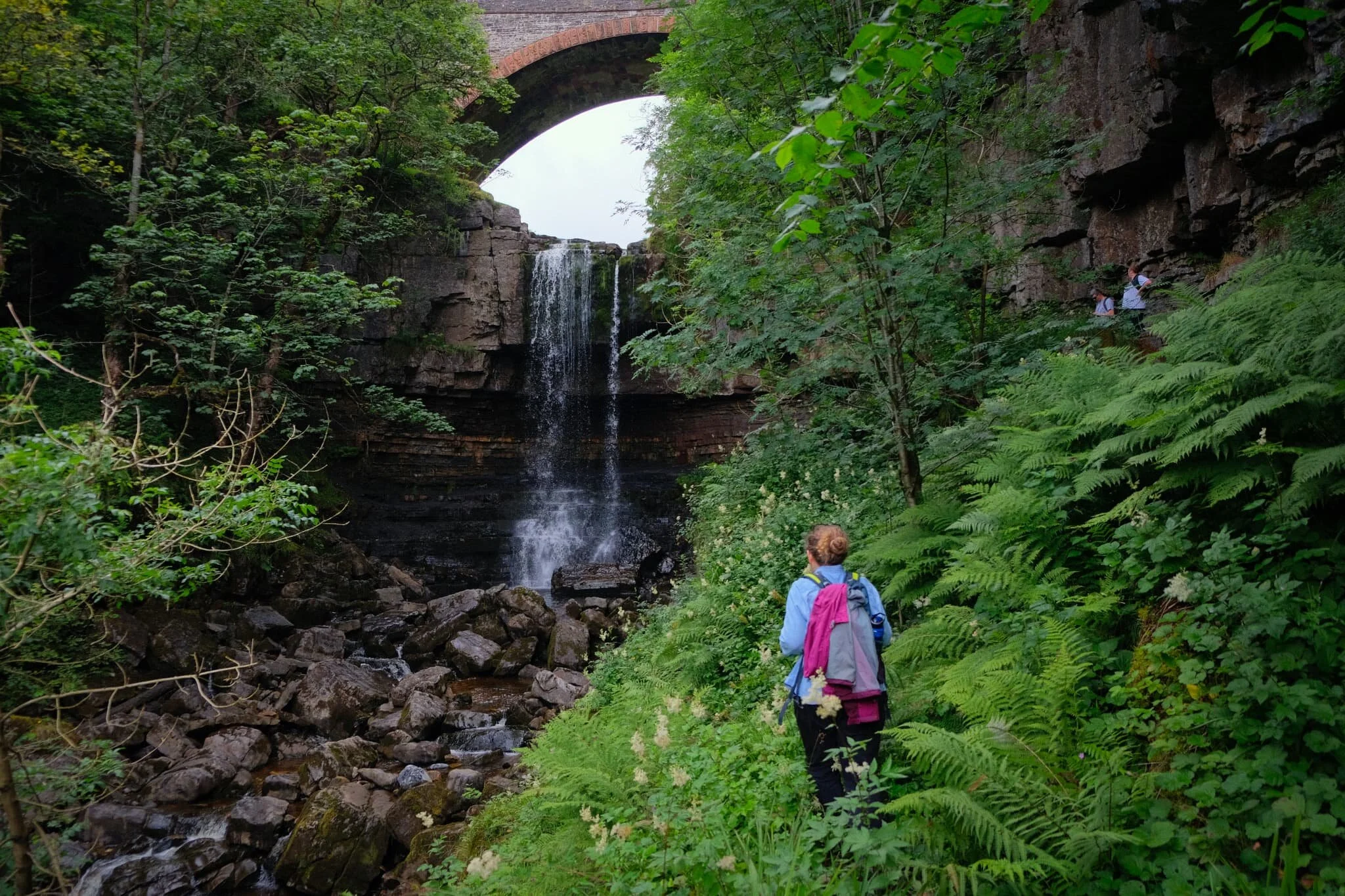
In actuality, half a kilometre upstream, this is Summerhill Force, which drops over a large limestone overhang known as Gibson’s Cave.
The rock here is Whin Sill, the exact same rock found at the head of High Cup Nick (you can read about our hike up to this epic valley here). The rock is extremely hard and resists erosion, forming columns and tessellating block pavements.
Not one of the tallest waterfalls, at only 18 ft high, but Low Force is certainly powerful and a damn impressive site.
Around the falls, the woods start changing colour. Autumn is coming.
You can more clearly see the rigid column structures that the Whin Sill rock is known for. Fellow hikers in the background provide a good sense of scale.
What I love about Low Force is that it’s very easy to get right next to the falls, and really feel the roaring power of the water as it crashes down, carving out chunks of land.
The upper section of Low Force. Just a delightful scene, on what turned out to be a beautiful day of clear light.
Soft light in the woods around Low Force.
After crossing Wynch Bridge (carefully, it’s a suspension bridge built in the 1830s), you can catch site of another set of cascades with Low Force in the distance.
Low Force, this time from its southern banks, with soft light highlighting the central pillar that separates the falls.
On our way to High Force I catch some Swaledale sheep mucking around on a raised boulder.
The epic High Force, and my first time photographing the waterfall from above. The falls plunge a sheer 70ft through the hard Whin Sill rock in the area. A truly awe-inspiring site.
Looking straight down the sheer 70 ft drop of High Force. Definitely a weak-knee moment.
From above High Force and looking back into the gorge the waterfall has been cutting for thousands of years.
We sat right next to the Tees above High Force for our picnic lunch. The red-brown colour in the water is from all the peat the river carries from the moorland of the North Pennines.
Families enjoy the sites and sounds of the Tees, hopping between boulders or pausing for food and drink.
Beyond High Force the landscape of Upper Teesdale really opens up, and we can make out some of the peaks of the North Pennines.
Our final destination in Upper Teesdale: Bleabeck Force.
It was lovely to see so much heather (Calluna vulgaris) in Upper Teesdale.
A dead Juniper tree (Juniperus communis) enveloped by a boulder.
A somewhat rundown farmstead, still apparently in habitation.
Ashgill Force, North Pennines, Summer
With the easing of lockdown restrictions in the UK, it’s my experience that tourism in the UK has never been busier.
With the easing of lockdown restrictions in the UK, it’s my experience that tourism in the UK has never been busier. It’s likely a result of a declining aviation industry and the extra hassle involved in holidaying abroad.
This means that Lisabet and I have been actively looking for alternative locations for hikes, photography, and exercise, as the Lake District and the Yorkshire Dales—the two National Parks we are sandwiched between—are absolutely chock full.
That’s no bad thing, though. A cursory look through Instagram’s #HiddenCumbria hashtag alerted us to a waterfall that we’d never heard of before: Ashgill Force.
This waterfall, just south of Garrigill in the North Pennines, is mightily impressive even when fairly dry. The waterfall crashes 55 ft over a rocky shelf, set in a deep gorge, and framed by Ashgill Bridge that carries the B6277 over it. There’s plenty to see even before you get to the falls too.
All photos shot on a Fujifilm X-T2 with a Fujinon XF 18–55mm f/2.8–4.0 lens using a customised Provia film profile. All these photos are 95% SOOC (straight out of camera).
The day started off pretty wet, but I could see the cloud cover was lifting and breaking.
Just outside Garrigill village the views soon started to open up.
Heading down to the South Tyne Trail, which we’ll follow alongside all the way to Ashgill Force.
This was a rather pleasant discovery! Just below Windshaw Bridge the South Tyne river has cut a fine gorge out.

Fascinating rock formations formed by the South Tyne river.
Further up the river a series of small cascades can be found, each more delightful than the next.
Gorgeous light play around these little cascades as the peeped in and out of the clouds.
A proper lovely scene.
Could do with more water though.
The waterfall is beautifully framed by the gorge it’s set in and the bridge above it.
Ashgill Force, though relatively dry, is still a sight to behold. The waterfall is one of the bigger ones I’ve seen in England, dropping 55 ft (not quite as big as nearby High Force in Country Durham, which drops 70 ft).
Above and beyond the waterfall, Ash Gill is calm and serene.
The B6277, which we followed all the way back to Garrigill. A scene of big sky and expansive landscape.
This part of the North Pennines feels very similar to Swaledale, for me.
Heading down Loaning Head lane, down the valley back to Garrigill.
Back at Garrigill village, now beautifully drenched in sun.
On the way back home, we stopped at the summit of Hartside Pass (1,903 ft) for a bite to eat and to enjoy the massive views back towards the Lakeland Fells.

High Cup Nick, North Pennines, Summer
The last time we hiked up High Cup Nick (trying that saying three times fast) was back in August 2013.
The last time we hiked up High Cup Nick (trying that saying three times fast) was back in August 2013.
Back then I was recovering from a recent mental breakdown.
On today’s hike to this epic chasm, I was stronger and healthier than I’ve ever been.
High Cup Nick, or High Cup Gill, is a short but steep U-shaped glaciated valley that cuts deeply into the North Pennine escarpment. Not only is it a spectacular sight for its sheer drops to the valley floor but it also features these columns and pillars of rock near the head of the valley; in places, these cliffs are 70+ ft high.
These cliffs of columnar dolerite is known as the Whin Sill, and it is exposed at various places throughout the North Pennines and further towards the North East of England. Perhaps two of the most famous examples of the Whin Sill can be found at High Force in County Durham—one of England’s most powerful waterfalls where the water drops off 22 m high Whin Sill cliffs—and at Hadrian’s Wall near Housesteads, Northumberland.
Lisabet and I set off early in the morning to ensure we could park safely at Dufton village, the start of our walk. Nine miles and 20,000+ steps later we returned to the car thoroughly exercised, cameras and phones filled with photos, and our brains filled with wonderful memories and experiences.
All photos taken on my Fujifilm X-T2 with a Fujinon XF 18–55mm f/2.8–4 lens using a customised Velvia film simulation.
A single foxglove (digitalis purpurea) points towards Dufton Pike (481 m/1,578 ft)
That’s right, a drystone wall. You know what I’m when it comes to drystone walls, especially if they give pleasing compositions like this.
A small hut by the side of the old quarry road.
Looking back down the route we’ve taken give us a moment to pause and reflect on the sheer open expanse of the Eden valley.
We’re gaining height. A break in the clouds illuminates Dufton Pike and Knock Pike (398 m/1,305 ft) beyond.
As we round the shoulder of Peeping Hill (510 m/1,673 ft) a look southeast reveals the flat-topped Middletongue Crag (456 m/1,496 ft) being highlighted, with Murton Pike’s (594 m/1,949 ft) gentle slopes looming above.
The first sign of what’s to come. The path continues up to the left but our gaze is fixated towards the steep valley of High Cup Nick and its rim of cliffs.
A small cascade tumbles down from Narrowgate Beacon (656 m/2,152 ft), known as Hannah’s Well.
My eye catches a slither of light scanning along the valley floor of High Cup Nick, highlighting the beautiful curves of the valley and the beck snaking its way towards the Eden valley.
Looking down the sheer drop to the floor and back up the other side.
As we approach the head of High Cup Nick our shooting frequency increases as the views get more and more epic. Here’s some of the Whin Sill cliffs on High Cup Nick’s northwestern flank.
This particular column of Whin Sill is known as Nichol’s Chair, named supposedly after a local cobbler who was challenged to climb the pinnacle then sole and heel a pair of shoes on its top.
Zooming in on the details of these cliffs, whilst the other side of valley gets blasted with light.
We’re not the only ones here. Hikers wander and rest by the head of High Cup Nick, enjoying the sights and views.
8 vertical frames, shot left to right and stitched together into a single panorama, reveal the full striking extent of High Cup Nick. A truly epic view of the “Grand Canyon of North England”.
The Whin Sill cliffs by High Cupgill Head are some of the tallest, around 70+ ft high.
A young couple rest and enjoy the views near the head of High Cup Nick.
After a spot of lunch we had a bit of a scramble down the gill at High Cupgill Head to grab some more views and photos.
Views such as this.
More fellwalkers make their way towards the head of High Cup Nick.
I wanted to show the scale of the Whin Sill cliffs and the precipitous drop in comparison to the tiny figures of people on the Pennine Way.
Streams of lights pour through the various gills in between numerous breaks within the Whin Sill cliff.
Tiny people near the edge of the cliffs at High Cupgill Head.
It’s, unfortunately, time to head back.
I tip-toed near the edge of the valley where Hannah’s Well tumbles down towards the valley floor as Strands Beck. This image is made up of four landscape frames at 18mm, shot from bottom to top, and later stitched together.
My lovely Lisabet enjoys the view back towards the head of High Cup Nick.
One last look back at the epic High Cup Nick.
A pleasant composition involving, yes, a drystone wall, Murton Pike, and some lovely light.
A Swaledale ewe staring me down.