
Sedbergh, New Year's Day, Cumbria, Winter
Happy New Year everyone!
Happy New Year everyone!
I hope you all had a merry time with those you love (which can also just be yourself). What are your goals for 2023? Let’s hope this year’s a little more… boring, shall we say?
To kick of 2023, Lisabet and I ventured east to Sedbergh. It’s been raining a lot in December, but we were hoping there’d be a teeny little break in the rain around lunchtime. And, incidentally, we had a table booked at the gorgeous Dalesman Country Inn for a New Year’s Sunday Roast.
We picked a trail that ran past the famous Sedbergh School, and down towards the River Rawthey. Here you join the Dales High Way and head east, past the Pepperpot and the ruins of Akay House, all the way to the New Bridge and back into Sedbergh, ready for a Sunday Roast.
Ultimately, we still got wet. But I did manage to get a few decent shots.
All photos taken on my Fujifilm X-T2 using my Vivitar “Series 1” 28‒105mm f2.8‒3.8 zoom lens. RAWs developed in Capture One for iPad, then tweaked and finished in Pixelmator Photo for iPad and Affinity Photo 2 for iPad.
Sedbergh, New Year's Day, Cumbria, Winter by Ian Cylkowski is licensed under CC BY-NC-SA 4.0![]()
![]()
![]()
![]()
Sedbergh’s full of these beautiful little yards and alleys that are always so photogenic.
Plenty of Sedbergh’s yards are still cobbled, too. In the distance you can just make out the now-rusty hues of the southern Howgills.
The graveyard of St. Andrew’s Church as you head towards the grounds of Sedbergh School. The present church dates from around 1500AD, but material from earlier churches here have been incorporated into the current building.
Over towards Baugh Fell (678 m/2,224 ft), the heavens opened and dumped their liquid shipment all over the fell.
Just up the river bank along the Dales High Way is the Pepperpot. The story of its origin has been lost in the mists of time. One legend states that it was constructed as an isolation house for a local land owner’s daughter who had Tuberculosis. The ruins of this building were reconstructed in 2019 and the building has been given to the local community.
As the Pepperpot is perched on an isolated drumlin, it enjoys lovely views around Sedbergh. I enjoyed the way the trees and drystone walls created wandering lines across the frame all the way up to Holme Fell on the left.
A vertical photo of the same compositional idea.
Across the valley towards the Howgills, Arant Haw catches a little bit of afternoon winter light.
Into Akay Woods, a piece of mosaic flooring and a couple of these stone archways are all that remains of Akay House.
Before the heavens opened up again, I managed to sneak a clear view of the Howgills from the Rawthey footpath. The members of the Howgills seen here, from left to right, are Crook (461m/1,513ft), Sickers Fell (498m/1,633ft), and Knott (429m/1,407ft).
After all the rain we’ve had, the River Rawthey was absolutely gushing with water. At the weir near New Bridge, the curves of the weir and the water caught my eye and I lined up a composition. Turned out quite nice!
Paused at New Bridge to snap these mossy branches above a raging River Rawthey.
Did you enjoy these photos?

St. Bees, Cumbria, Winter
For our final full day of our mini-break, a trip to the coast was in order.
For our final full day of our mini-break, a trip to the coast was in order.
The weather forecast for the day had the fells of the Western Lake District blanketed in clouds. Instead, the westernmost point of Cumbria seemed like a good alternative.
St. Bees is a small village on the western coast of Cumbria. In comparison to the deep dales and high fells that characterise the Cumbrian landscape, most of Cumbria’s coastline consists of long sandy beaches, stretches of shingle, the occasional dune, and mudflats nearer Morecambe Bay. The exception to this rule lies at St. Bees, where St. Bees Head towers above the coastal village.
St. Bees Head is split into two sections: the South Head (which overlooks St. Bees village, and is known locally as the Tomlin), and the North Head. In between the two headlands is Fleswick Bay, accessible only by foot or sea. The small bay consists of deep shingle underfoot and towering sandstone cliffs in an array of otherworldly and seemingly impossible shapes and arrangements.
It’s been a good few years since we’ve hiked St. Bees Head, and it’s nice to reaffirm that our fitness has greatly improved since the last visit. St. Bees Head, and Fleswick Bay, did not disappoint.
All photos taken on my Fujifilm X-T2 using my three prime lenses: a Fujinon 23mm f/2.0, a Laowa 9mm f/2.8, and an adapted 55mm f/2.0. All images made in-camera using a custom Velvia-based recipe, finished for the web in Pixelmator and Darkroom.
Our destination for the day: St. Bees Head from the shore at St. Bees.

The views open up the minute you step on the cliff path. It’s fair to say that St. Bees Head has seen it’s fair share of erosion.
The cliff path reveals the extent of the St. Bees coastline. Much of the Cumbrian coastline is like this.
The first section up to the top of the South Head is quite the pull.
Yeah, that’s pretty steep. If the path were more wet and muddy, I’d have really struggled.
Thankfully it’s not long before the cliff path levels out, and gorgeous panoramas to St. Bees village and the Lakeland fells open up.

Near the old coastguard lookout, a fantastic view towards the headland’s sheer cliffs and Fleswick Bay beyond is possible. The path used to follow this cliff top quite closely, but erosion has meant the path has moved further inland.
To be safe, we stayed on the inland side of the path. The cliffs surrounding Fleswick Bay become more visible.
Despite the heavy cloud cover, the light conditions were being very cooperative.
Lots of gorse, Ulex europaeus, can be around the cliff tops of St. Bees Head. They’re not quite flowering yet, but those that have offered a nice composition as we neared Fleswick Bay.
The way down to Fleswick Bay nears.
Getting down to Fleswick Bay can be tricky. The path is often muddy, and the deep gill leading out to the bay is lined with moss-covered loose boulders. I did, dear reader, fall on my ass trying to get to the bay.
Our preservation paid off. This is Fleswick Bay and her incredible cliffs.
My lovely Lisabet, providing a sense of scale against the deep red jenga-like cliffs of Fleswick Bay.
It was time to fit my ultra-wide 9mm lens on to nab some expansive compositions of Fleswick Bay’s strange cliff textures.
Millennia of wave action have torn chunks off the cliff face, and smoothed out boulders.
Getting right low and underneath the cliffs with my ultra-wide lens provided some incredible angles.
Most of the sandstone cliffs are wet and constantly dripping water from the grass and soil above.
Our footprints are testament to how soft and deep the shingle goes. Really hard to walk in. We ventured as far out as we dared with the tide making its way in.
What now follows is a celebration of the weird and wonderful textures and patterns of Fleswick Bay’s sandstone cliffs.

This is the deep gill that flows out into Fleswick Bay.
And this is the reason why it’s quite hazardous to navigate your way back onto the cliff path.
But navigate we did. We were the only ones at Fleswick Bay this whole time. Everyone else seemed more interested in sticking to the cliff path.
One last look back at the cliffs of Fleswick Bay before making our way back to St. Bees.
Heading back to St. Bees, the light got better and better and I went on a shooting spree whilst it lasted. In the distance, a think bank of cloud sits on top of the Black Combe fells.
As the sun began its trajectory down into the sea, plenty of people will still heading up and down the cliffs of St. Bees Head.
St. Bees getting drenched in golden wintersun with the dark Muncaster Fells behind.
My lovely Lisabet, striding purposefully on towards St. Bees village as the sun bathed the land in light.
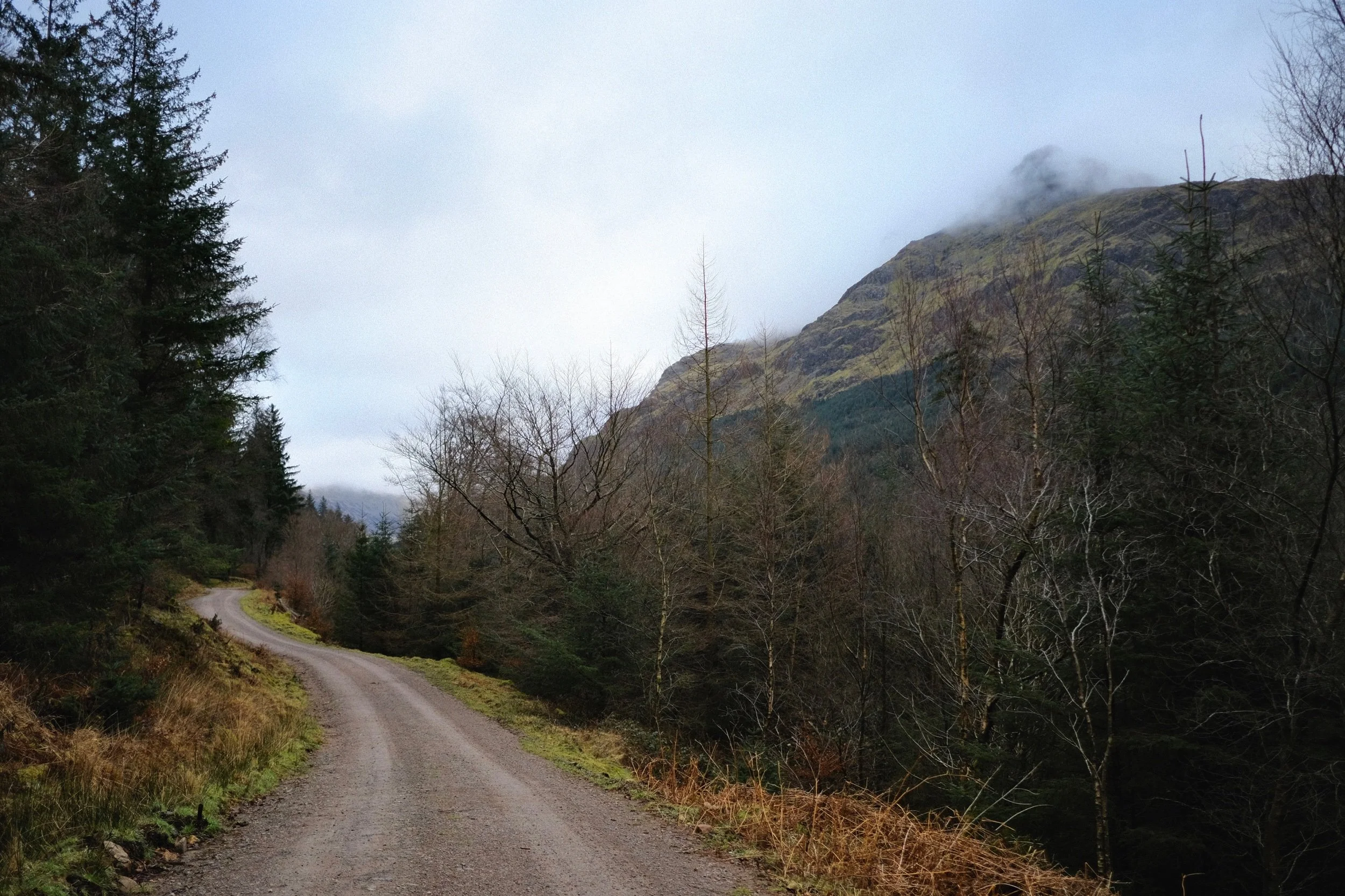
Ennerdale, Lake District, Winter
Compared to Buttermere’s clear blue skies, Ennerdale could not have been more different.
Compared to Buttermere’s clear blue skies, Ennerdale could not have been more different.
I think the last time we were at Ennerdale was in April 2017. Goodness. That’s coming on to 5 years now. It’s one of my favourite places in the Lake District, with a distinctly unique “vibe” compared to any other area in the National Park.
Ennerdale is a long valley by Lake District standards, measuring around 10-miles long. There are no settlements here, save for the Low Gillerthwaite Field Centre, Ennerdale YHA, and Black Sail Hut right at the head. Ennerdale Water sits at the foot of the dale, offering views all the way down the valley towards some of the Lake District’s biggest peaks: Great Gable, Steeple, and (one of my favourites) Pillar.
In 2003 the major landowners of the valley—United Utilities, the National Trust, and the Forestry Commission—joined forces to create the Rewilding Ennerdale partnership and project. The project’s stated goal is:
“[…]to allow the evolution of Ennerdale as a wild valley for the benefit of people, relying more on natural processes to shape its landscape and ecology.”
Ennerdale does have a massively different feel compared to the rest of the Lake District. It feels more Scottish in a way.
Although on this hike we didn’t see much of the sun, the low clouds did interact with the high fells beautifully, creating gallons of drama for us to photograph.
All photos shot on my Fujifilm X-T2 using my three prime lenses: a Fujinon 23mm f/2.0, a Laowa 9mm f/2.8, and an adapted Pentax SMC 55mm f/2.0. Images made 95% in-camera using Øyvind Nordhagen’s “Modern Negative” Fujifilm recipe.
Following the road from the car park, the views open up and reveal the huge Ennerdale fells tussling with the clouds above.
Across Ennerdale Water, Crag Fell slopes down to an abrupt toe known as Angler Crag, before plunging into the deep lake.
This was the most sun we saw all day. Worth it though. Caw Fell, Haycock, and Scoat Fell fight with the clouds.
A closer view of Angler Crag. It is technically possible to complete a circular hike around Ennerdale Water, but the difficulty is in navigating around this awkward crag.
The cloud cover starts to lift a little bit, with Steeple’s shadow suggesting an appearance.
Lots of trees near the lake shore are covered in thick carpets of moss. Beautifully eldritch.
Beautiful light highlights the reaching arms of this moss-covered tree.
Near the Low Gillerthwaite Field Centre, the forest cover recedes a little and we get out first glimpse of the mighty Pillar. My excitement levels build.
We followed the winding forest track towards Middle Bridge, which cross the River Liza. This would signal our way back down the other side of the valley. Pillar gets closer…
Swirling clouds wrestle with the summit of Pillar.
Like a lot of the Lake District, Storm Arwen took casualties in Ennerdale too.
These trees managed to survive…
…but these two giants didn’t, completely uprooted and tossed aside by the powerful winds of Storm Arwen. Incredible.
Middle Bridge offers beautiful views looking all the way down the rest of Ennerdale.
The River Liza tumbles down the valley here in a series of cascades and falls, each with its own sublime turquoise and azure plunge pools. The water clarity was astonishing.
We crossed the Liza via Middle Bridge, and took the official Liza Trail back towards the foot of Ennerdale. But not without another look back at the crystal clear river and its falls.
Navigating the Liza Trail alongside the river back to the Forest path was tricky, given that several chunks of it had been washed away by Storm Arwen. But views like this from the forest trail made up for it.
Ancient sheep enclosures have long been left to be reclaimed by nature.
Ennerdale Forest, growing taller everywhere.

Buttermere, Lake District, Winter
It’s time for a mini-break.
It’s time for a mini-break.
We were planning for a Christmas break away in Scotland. But after the emergence and subsequent rise of the SARS-CoV-2-Omicron variant, we decided to cancel it.
One month on, with the situation more clear—and Lisabet transitioning between jobs—we decided to book a few days off and enjoy a long weekend around West Cumbria. We’ll be based near Cockermouth, but on the way we decided to take the scenic route via the Newlands Pass and into Buttermere. A walk around Buttermere’s gorgeous lake was in order.
And what a decision that was! We were greeted with clear blue skies, no wind, gorgeous light, and crystal-clear reflections. A fantastic way to start out mini-break.
All photos shot on my Fujifilm X-T2 using my three prime lenses: a Fujinon 23mm f/2.0, a Laowa 9mm f/2.8, and an adapted Pentax SMC 55mm f/2.0. Images 95% made in-camera, finished for web in Pixelmator and Darkroom. I used Øyvind Nordhagen’s Modern Negative Fujifilm recipe.
The way down into Buttermere after navigating the beautiful Newlands Pass. With the High Stile range in view, excitement levels build.
Honestly, some church builders have a wonderful sense of setting. This is St. James’ Church in Buttermere. The original chapel was built in 1507, with the more modern construction dating from 1840 and restored in 1930.
First thing’s first, we needed to get down to the shores of Buttermere. But when we did, goodness me… I mean, look at it!
From Buttermere’s southern corner, the views back across the lake to the Grasmoor and Newlands fells were astounding.
Looking down Lorton Vale towards Mellbreak, the main fell that overlooks Crummock Water.
Directly across Buttermere, the Robinson fell crags of High Snockrigg and Goat Crag are illuminated in the late-morning wintersun.
Directly above us, the High Stile range looms over our heads.
Buttermere is ringed by so many distinctive fells, but arguably the one that commands your attention the most is Fleetwith Pike, seen here perfectly reflected in Buttermere’s waters.
I decided to play around with some compositions using my ultra-wide 9mm lens.
The path starts to open up as we near the edge of Burtness Woods directly beneath the High Stile range.
The way ahead, with Fleetwith Pike glowing like one of the Pyramids of Giza.
Across the water from Buttermere’s southwestern shore, Hassness Country House is a veritable beacon in the low wintersun.
The point where we turn away from Fleetwith Pike, towards Buttermere’s northeastern side.
The outflow of Warnscales Beck, looking back towards the Crummock Water fells.
High Crag looming above the Buttermere trail. Though not busy, there were a fair few folk wandering around various parts of the trail with us.
At Gatesgarth Farm, the trail becomes the road around the lake, before eventually rejoining the footpath around the northern shore of Buttermere. Before turning away, I get another look at beautiful Fleetwith Pike.
Couldn’t miss the opportunity to nab a composition of this delightful farm cottage set against the High Stile range.
From Buttermere’s northeastern side, the profile of the High Stile range becomes more apparent. There are three main peaks: High Crag, High Stile, and Red Pike.
One of my favourite compositions and views to be found around Buttermere.
A lone tree along the northeastern shore of Buttermere catches the light, a contrast against the deep shadows of the High Stile range.
The shingle beach of Hassness Crag Wood offered a lovely leading line towards Mellbreak in the distance.
A field of Herdwick, happily grazing underneath the craggy wall of the Robinson/Hindscarth Fells.
A clear view of Mellbreak and its reflection.
In order to carry on walking around the northern shore of Buttermere, you need to navigate through Hassness Tunnel.
Popping out of the tunnel, the view back towards Fleetwith Pike and Haystacks was exquisite.
Time for my ultra-wide lens to nab some compositions of the High Stile range, with the sun setting behind them.
With previous cameras and lenses, I was never able to get a good shot of all three of High Stiles’ peaks. Now, with my 9mm ultra-wide, I was able to get all three of them in and more!
My 55mm was able to zoom right in and capture some of the gorgeous detail on Mellbreak.
One last look at Fleetwith Pike in the sunset light.
What a gorgeous day.

Levens Hall Deer Park, Cumbria, Winter
I hope you like trees.
I hope you like trees.
With other duties and tasks that needed to be completed today, we decided on a lovely 10,000-step walk around the Levens Hall Deer Park. The park was landscaped some 300-odd years ago, around the same time as the gardens of the historic Levens Hall. As such, many of the trees in the park are centuries old and, unfortunately, some of them have suffered after Storm Arwen’s 100mph winds.
Levens Hall Deer Park is home to Black Fallow Deer and a herd of rare-breed Bagot goats. Whilst we didn’t see any of the distinctive goats, we did manage to spot some of the deer, happily chilling and grazing in the grounds.
With the trees devoid of leaves, there were opportunities to focus more on the shape and texture of each tree instead. With the sun out, we got some delicious golden side lighting, which I happily took advantage of with some more unusual close-up compositions.
All photos shot on my Fujifilm X-T2 using my three prime lenses: a Fujinon 23mm f/2.0, a Laowa 9mm f/2.8, and an adapted Pentax SMC 55mm f/2.0. Images made 95% in-camera using Øyvind Nordhagen’s Modern Negative Fujifilm recipe, finished in Pixelmator and Darkroom.
The main lay-by near the park was already full, so we had to drive further up the A6 to find the second, smaller, lay-by. Not a problem, you just follow the mossy and slippery path all the way to park entrance.
A beautiful iron-wrought gate attached to some of the cottages near the park.
Once in the park, it was already shaping up to be a beautiful day.
With their leaves gone, it felt to celebrate the overall shape and “personality” of each tree.
Some of them still appear to have remnants of their autumn foliage on display.
One of many Storm Arwen casualties around the park.
It was nice to see families around enjoying the park too.
It blows my mind to think of the forces involved to rip a strong-looking tree like this in half. What a storm…
If some of the ancient trees suffered, then the surrounding dry stone walls had no chance.
These cottages must have some smashing views of the Deer Park and perhaps beyond the Morecambe Bay.
A tree stump being consumed by fungi provided me with some delightful textures to play with.
The extended loop of the circular park walk involves walking up to Force Falls, crossing the bridge over the river, and following the road back into the other side of the park. I weren’t complaining; Force Falls is always stunning.
The southeastern side of Levens Hall Deer Park was already giving us some beautifully gnarly trees to gawp at.
My lovely Lisabet, in her natural element.
This cottage on returning to the Deer Park caught my eye. Beautifully idyllic, and the light was the cherry on top.
So beautiful. Practically a sculpture in its own right
One of the distinctive aspects of Levens Hall Deer Park is “the Avenue”, which is lined with a variety of ancient trees, particularly oak. Near Park End cottage, a separate branch of the avenue had its own otherworldly collection of trees.
One of my favourite photos from the whole shoot. I’ll probably use this as a phone wallpaper.
I mean, just check out those textures…
After capturing some close-up compositions on my 23mm and 55mm, it was time to whack on the ultra-wide 9mm to really play with those textures, light, and angles.
I really dig this composition, I must say.
Some of the twists and knots in these trees were almost impossibly otherworldly and magical..
It’s not often I do close-up compositions using my ultra-wide lens, but the texture on this tree just called for it.
Anyone else see something of H. R. Giger’s work or style in this tree?
Onwards through the Oak Avenue, with a Storm Arwen casualty lying across. Can’t imagine how old that tree was…
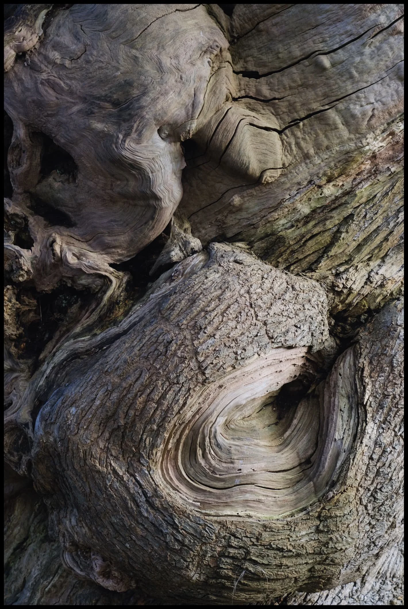
I love the combination of textures here, from whirling and smooth to stubbly and geometric.
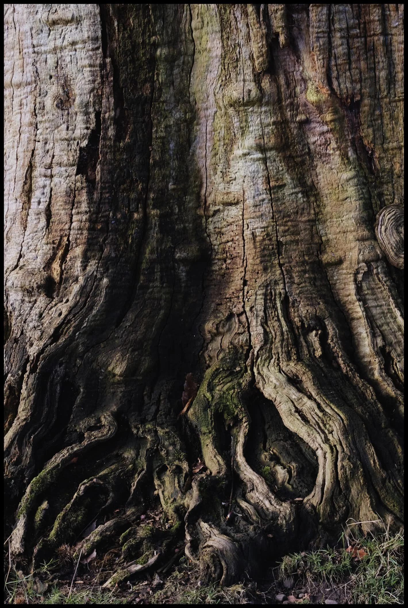
The base and roots of another tree gave me Sleepy Hollow vibes.
My lovely Lisabet, being the Wood Elf that she is, inside a hollow tree.
Looking back down the Oak Avenue we sauntered up, past another destroyed tree.
Nearing the end of our walk, this cluster of trees—all seemingly “looking” in the same direction—caught my eye.

Sometimes you just have to shoot chaos, and let someone else’s brain find something they can point to.

The day was a joy of wonderful soft light and glorious eldritch textures.
More days like this, please.
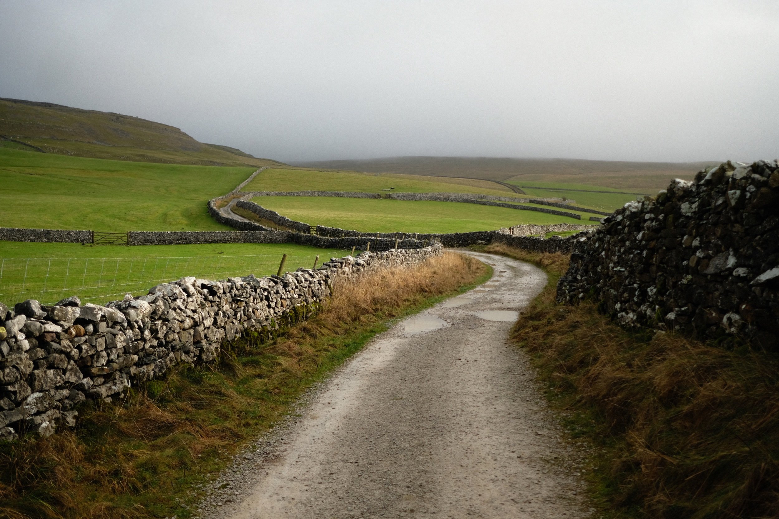
Crina Bottom, Yorkshire Dales, Winter
Temperatures are still down but conditions are rather contentious at the moment.
Temperatures are still down but conditions are rather contentious at the moment.
That didn’t stop us from throwing caution to the bitterly cold wind! After examining my 90 million weather apps plus satellite radars, it looked to me that the further east we went, the better our chances for drier conditions.
To the Yorkshire Dales!
We settled on a hike up to Crina Bottom from Ingleton. We did plan on an additional hike from Horton-in-Ribblesdale to Hull Pot, but we unfortunately ran out of time. Nevertheless, Crina Bottom is lovely. It’s famed for its wonderful view of Ingleborough right above the farmstead (a shot of which you can see here). Unfortunately for us on this day, the cloud base level wasn’t due to lift anywhere above 500–600m, and Ingleborough is 726 m high.
Nevertheless, the low winter light was beautiful, casting isolated golden light across the landscape, drawing long shadows, and the low cloud level made for more minimalist landscape compositions.
All photos shot on my Fujifilm X-T2 using my Fujinon 23mm f/2.0 prime lens. Images were made 95% in-camera, with a final curve adjustment in Pixelmator Photo and framing in Darkroom.
We found a spare lay-by off the Ingleton–Hawes road, and already the light was looking gorgeous.
There’s a sparseness to a winter landscape that’s dramatic and beautiful.
It’s only 2.5 miles from the start of this track, known as Fell Lane, to the mountain that is Ingleborough. As such, it’s rather steep in places.
Beautiful golden light greets us as we enter the high-walled portion of Fell Lane.
Across the valley, Twistleton Scar gets drenched in light. Chunks of the drystone wall are still collapsed after Storm Arwen.
Around this part of the track you’d normally expect to see the shoulders of Ingleborough. Not today.
Looking across the fields to the winding walls that guide Fell Lane.
Over the fields towards the Aire Gap and beyond to the Forest of Bowland, the clouds race across the sky and the sun punches through where it can.
Crina Bottom, a remote farmstead that was fairly recently on sale. I think it’s been purchased now. No doubt it will see lots of hikers who use this bridleway to ascend Ingleborough.
Just imagine a giant flat-topped mountain framed in between those trees…
The last time we hiked up to Crina Bottom was August 2017, when I was shooting with my Sigma dp0. Definitely a different world in the winter.
We decided there wasn’t really any point attempting an impromptu hike up to Ingleborough, given that it was completely engulfed in clouds, so we made our merry way back down Fell Lane.
Random bit of fleece, probably from a Swaledale sheep, snagged in the barbed wire.
The long lonnin (lane) back down to Ingleton.
The shadow of Twistleton Scar makes an appearance as storm approaches us from across the Forest of Bowland.
Beautiful Ingleton lay before us near the bottom of Fell Lane. Hmm… a flapjack sounds good about now…
We decided on a wee extra wander into Ingleton town proper to procure a few groceries from the Co-op before hiking back up to the Ingleton–Hawes Road. Ingleton is in a wonderful setting.