
Brigsteer Park, Lake District, Spring
I wanted to see a lot of bluebells one last time for this year.
I wanted to see a lot of bluebells one last time for this year.
A work colleague tipped me off about Brigsteer Park, a woodland south of its village namesake, Brigsteer. The village sits underneath Scout Scar, and there’s a surprising amount of woodland underneath this fell.
So, Lisabet and I parked up at Helsington St. John’s Church and plotted a route down the fell slope, through a Bee Reserve and into Brigsteer Park for a ruddy good exploration.
All photos taken on my Fujifilm X-T2 using two of my prime lenses: a Fujinon 23mm f/2.0 and an adapted Pentax SMC 55mm f/2.0. Images developed using RNI Films’ Kodachrome film profiles.
The views from the car park Helsington St. John’s church are sublime. All the way across the Lyth Valley to the Lake District fells.
The southern shoulder of Scout Scar and the small road that allows access to Helsington St. John’s Church.
As we navigate the footpaths down the fell slope, Whitbarrow commands your attention directly across the Lyth Valley.
Couldn’t resist a shot of this gorgeous old house, covered in ivy.
A delightful little cottage on Park End Lane just before you enter Brigsteer Park.
Whoever lives at the cottage is a keen gardener. We had to look up what these weird and wonderful plants were. Turns out they’re probably Chilean Rhubarb, Gunnera tinctoria. Also, not actually related rhubarb though you can apparently consume Chilean Rhubarb as you would normal rhubarb.
Looking back at this impossibly idyllic scene before we head into the woods.
It turns out that Brigsteer Park is a proper woodland, thick with growth and full of old trees.
An old tree with its own “cane”.
Look at this old yew tree with its “ligaments” and textures. Isn’t it magnificent?
Another old yew, found further into the woodland.
As we neared the exit, I turned back to snap this scene. Unfortunately, I didn’t see any sign of carpets of woodland here at Brigsteer Park. Perhaps we were in the wrong bit?
Whitbarrow Scar once again commanding our attention from across the Lyth Valley.
After carefully navigating through some young cows and bullocks, we returned to Park End Lane. The gardener’s cottage here, cosily nestled in the woods of Brigsteer.
Everywhere is exploding in colour and wildflowers.
Brigsteer Causeway, which cross the wetter and more swamp-like part of the Lyth Valley.
Brigsteer is such a bonny village.
I mean, come on.
Not a bad place to do the rounds.
As we started climbing the road up back towards St. John’s Church, the views opened to us again. Here you can see right across the Lyth Valley and even the Kent Estuary towards Arnside Knott.
Not a bad way to spend the morning.
Did you like these photos?
Then support me.
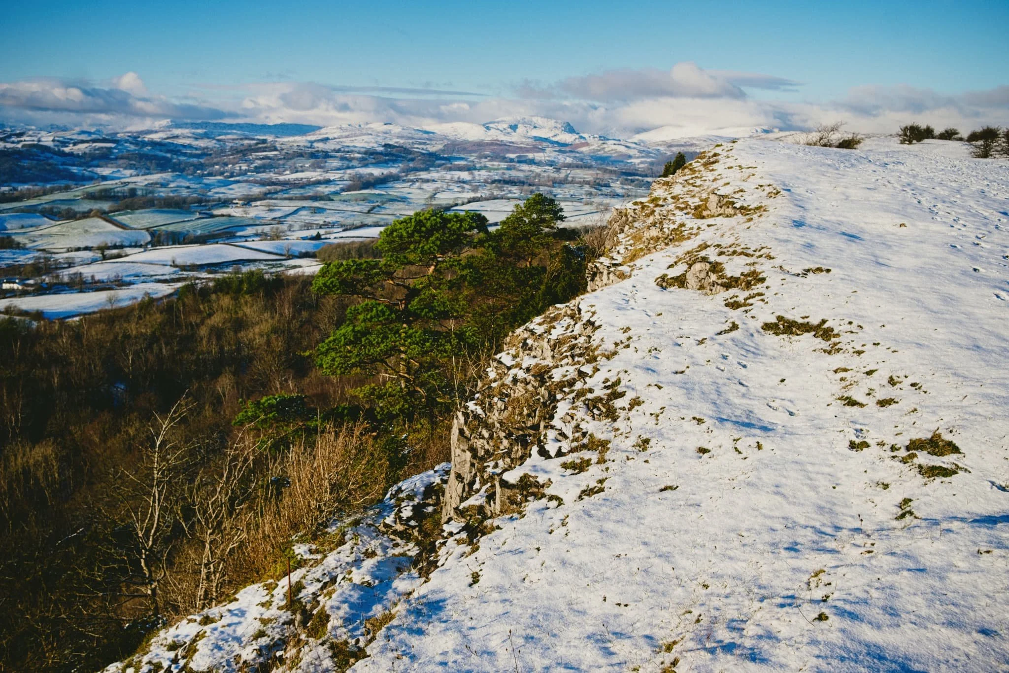
Scout Scar, Lake District, Winter
On Saturday just gone, my Dad celebrated his 68th birthday!
On Saturday just gone, my Dad celebrated his 68th birthday!
Do you know what else happened on that day? Storm Arwen arrived. And it brought with it sustained winds of over 60mph with gusts approaching 100mph. Ultimately it caused power cuts for tens of thousands of homes across the UK as trees were torn from their roots and slammed into power lines.
In Kendal, we were one of the lucky ones. So rather than try to get to Dad’s house for his birthday, which involves driving over the A6 or M6 at altitudes several hundreds of metres above sea level, we postponed the get-together for Sunday.
This was fortuitous because as Saturday blended into Sunday, Storm Arwen left and snow arrived. By the time Dad arrived in Kendal, a fresh coating of powdery snow had packaged Cumbria in wintery goodness. What to do? Go on a walk, of course!
So we hiked up an old favourite, Scout Scar, to get some crackin’ winter views across to the Lakeland fells. And surely we did.
A smashing day all round.
All photos taken on my Fujifilm X-T2 using my Fujinon 23mm f/2.0 prime lens. Images were developed with RNI’s Fortia SP film profile, then finished off in Affinity Photo.
The goal initially was to drive up to, and park at, the main Scout Scar car park. We had to abandon this, though, as the entrance to it was slick with slushy ice and compacted snow. Instead, we navigated up Brigsteer Road and began the hike at the lay-bys behind Scout Scar. Already, the light was looking delicious.
My lovely Lisabet and my Dad, taking in the scenery in their own ways. Far, far in the distance are the comely shapes of the Howgills, covered in fresh snow.
It wasn’t long until we came across our first sledging family, excitedly pulling their sledge back up the fell side for another ride.
As we gain height, the views looking back across Kendal to the Howgills open up. Our excitement builds. The day is crystal clear.
And there they are, the Lakeland fells, covered in the first of 2021’s snow.
Storm Arwen made damn sure there were no autumnal leaves left on the trees. A landscape of auburn and yellow has quickly been replaced with fresh white snow.
My lovely Lisabet, glowing as she does.
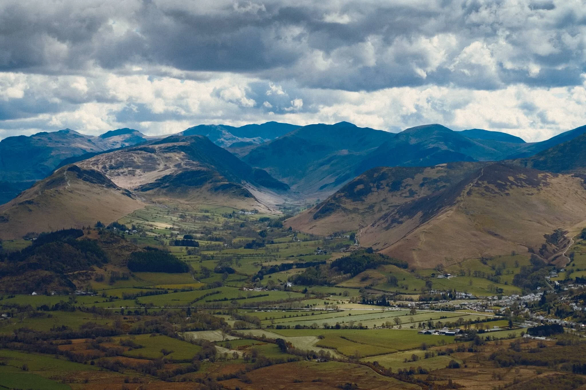
The Kentmere and Longsleddale fells, in particular, were looking absolutely stunning. Mountains really do look taller with snow on them, don’t they?
I’ve been up Scout Scar so many times. I never get sick of the views from its precipice.
Something else I never get sick off: Lisabet’s hair.
Windswept trees, stripped bare of their leaves as the sun begins to set.
As we began our way back down the fell, there were still plenty of people making their way up.
Clouds laden with snow quickly started to form over Kendal.
The setting sun managed to creep underneath the gathering clouds, shooting beams of golden light across the tree tops.
A crackin’ end to a lovely day.
Dodd Woods, Lake District, Spring
After an unusually dry and cold April 2021, the rain has returned.
After an unusually dry and cold April 2021, the rain has returned.
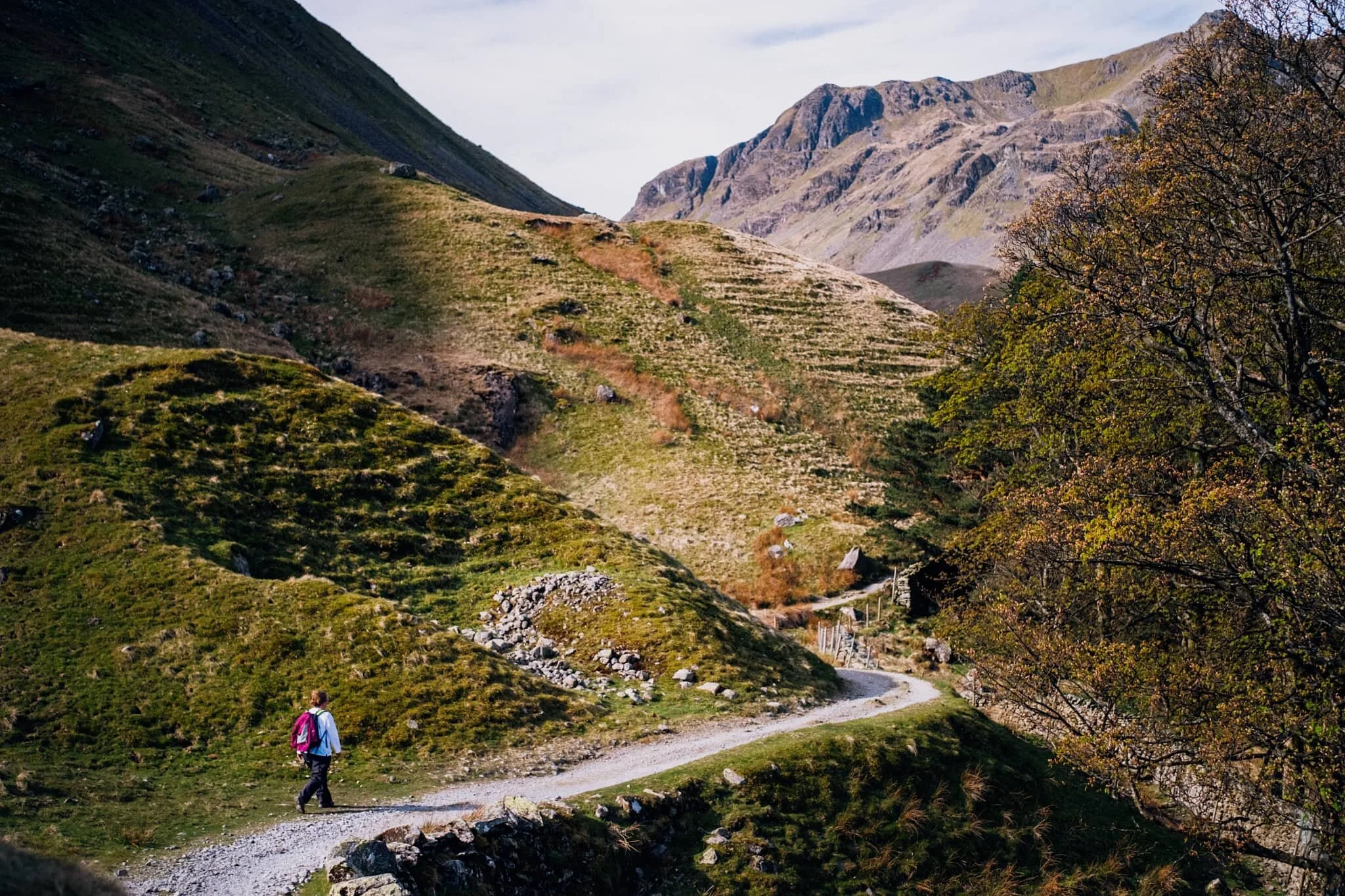
This Bank Holiday Lisabet and I planned on a long hike through the Mallerstang valley in the Yorkshire Dales, a favourite of ours. However, reading all the weather radars and forecasts indicated a lot of rain was on its way through South Lakes and the Yorkshire Dales. By contrast, the northern Lake District looked pretty good. So we changed plans and embarked on a hike up Dodd (502 m/1,647 ft), a small fell that came highly recommended by a friend of mine.
Dodd is part of the Skiddaw range, a massive bulk of fells to the north of Keswick, which tops out at Skiddaw itself at 931 m/3,054 ft asl. Most of the fell is covered in trees as it’s owned by the Forestry Commission but the summit is bald, allowing for extensive views towards either Derwentwater and the Newland Fells or Bassenthwaite Lake and out towards the Solway Firth.
Despite changeable conditions, the car park was extremely busy and we were lucky to get parked where we did. Thankfully there is plenty of signage around Dodd Woods and we simply followed Dodd Summit Trail, snapping happily along the way. There is a lot to be said for roaming around dense woods and the quality of light you get, not to mention the incredulous views you get from around the summit of Dodd.
All photos taken on my Fujifilm X-T2 using two of my prime lenses: a Samyang 35mm f/1.2 and an adapted Pentax SMC 55mm f/2.0. Developed using RNI’s Kodachrome film profiles.
The clarity of light was superb.
Lots of families wandering around Dodd Woods, enjoying the scenery and crisp sun.
I had to line up a composition involving this unusual tree, which had formed a sort of natural arch over the footpath.
Skill Beck, like a lot of rivers in the Lake District at the moment, was very dry and barely a trickle, as it tumbled through the woods.
I love the soft transitions of light and shadow you get in the woods.
We continue upwards, following the Dodd Summit Trail.
About three quarters of the way through the hike, the tree cover starts to open up, letting in more light. I quickly snapped this photo of my lovely Lisabet as she entered a zone of open light.
Underneath Dodd summit I spotted this wonderful crag marked with flecks of vivid orange and red. I wonder if there’s iron ore in the rock around here?
Our first glimpse of the views that Dodd offers. And we weren’t even at the top yet! Absolutely immaculate. Showing Derwentwater and its fells, with the bonny town of Keswick to left.
The Newland Valley and its fells, with the Dodd Summit exit trail below.
Again with that soft woodland light…
I have to remind myself, when I’ve got my head down hiking up a fell, to always look back. Had I not done so, I would’ve missed this! The view all the way back towards the Helvellyn range, and you can even clearly see the Helvellyn (950 m/3,118 ft) summit itself, catching some highlighting!
Bassenthwaite Lake framed by two trees; famously cited as the only “lake” in the Lake District (that is, the only lake with the word “lake” in its name). The atmosphere was so clear you could also make out the Solway Firth and the Galloway mountains in Scotland.
And we reach the summit. Some of the best views of the Northern Lake District I’ve ever seen.
The Lorton Fells and Grisedale Pike. Little hovering spots of light scan across the land.
My lovely Lisabet at the summit, getting those views.
I popped on my 55mm lens to zoom in further and pick out specific scenes from the vast panorama available from the summit of Dodd. The Newland valley and fells, in particular, were looking absolutely splendid.
Lord’s Seat (552 m/1,811 ft) from across Bassenthwaite Lake.
Honestly, I could’ve taken thousands of shots from the summit of Dodd…
Grisedale Pike (791 m/2,595 ft) catching some lovely light above the Whinlatter Forest.
Following the narrow trail back down the slopes of Dodd
As we climb down the wooded fell slopes, the landscape changed from craggy to mossy and grassy.
Lovely light catching the trees and footpath.
Heading our way back down to the car, soft afternoon light blooming through the woods. I liked the tree on the right, looks like a tuning fork.
Grisedale, Lake District, Spring
Grisedale has to be in my top 3 favourite Lake District valleys.
Grisedale has to be in my top 3 favourite Lake District valleys.
I have a fairly troubled history with this place. The last time both Lisabet and I visited it was the middle of summer on a clear and hot day. We hiked all the way from the foot of the valley to Grisedale Tarn and back down. About 7 miles and 1,300 ft of ascent. In mid-20s heat, with no wind or clouds. Whilst being 23/24 stone. I suffered on that walk, and stumbled a lot on the way back down, which angered me.
Now I’m 7-stone lighter, much fitter, and mentally better. It was time to revisit this gorgeous valley, especially as it’s my birthday weekend (38 years on this planet, goodness).
Grisedale is a tributary valley of Patterdale, located in the north-eastern Lake District. Not to be confused with Grizedale Forest, which I’ve also been to. There’s quite a few Grisedale in Cumbria and North Yorkshire, and the etymology is the same: Old Norse gris meaning “pig” or “boar”, and Old Norse dalr meaning “valley”, giving us “valley of the boars”.
Most people access Grisedale for the purposes of summitting Helvellyn via Striding Edge, one of the “classic” Lakeland fells for thrill-seekers. But Grisedale itself has so much to offer, especially the views toward the head of the valley, featuring the craggy faces of Nethermost Pike (891 m/2,923 ft) and Dollywaggon Pike (858 m/2,815 ft), both ultimately subsidiary tops of Helvellyn itself (950 m/3,118 ft).
We arrived good and early, pre-8am. By the time we returned to the car, the car park was full as well as all the lay-bys and roads around Ullswater.
This summer is going to be insanely busy.
All photos shot on my Fujifilm X-T2 using my three prime lenses: a Samyang 35mm f/1.2, a Laowa 9mm f/2.8, and an adapted Pentax SMC 55mm f/2.0. Developed using RNI’s E100G film profile.
Lacing up.
As soon as you pop out of Waterfall Woods, this is the view that greets you. Look at it. One of the best valley backdrops in all of Lakeland.
Lambing is in full flow in the Lake District now. There are plenty of Herdwicks in Patterdale, but in Grisedale there are more Swaledales.
Heading through Elmhow Plantation, when an old stone barn catches our eye for a composition. Especially lovely as we were sitting in the shadow and the morning sun was starting to catch the Helvellyn fells.
Heading through Crossing Plantation as we get closer to the head of Grisedale. Dollywaggon Pike glows like a beacon in the morning sun.
Exiting Crossing Plantation, with the sheer slopes of St Sunday Crag (841 m/2,759 ft) rising to our left.
My lovely Lisabet looking tiny underneath Dollywaggon Pike. The interesting little crag to the left underneath the fell is referred to on OS maps simply as “Post”. The more you know.
Looking back down Grisedale from whence we came. In the distance is the hulking mass of Place Fell (657 m/2,156 ft).
After reaching the head of Grisedale we crossed the tiny footbridge and started our way back down the north-eastern side of the valley. We stopped at Nethermostcove Beck to shoot some compositions looking towards Eagle Crag, as well as for refreshment.
One of the finest scenes in Grisedale.
As we neared the foot of Grisedale, several gates offered some lovely compositions involving the full expanse of the valley. St. Sunday Crag to the left, and the Helvellyn fells to the right.
An older gate, still in use.
Back at the valley bottom, near Waterfall Woods, I attach my 9mm ultra wide lens to use the trees as a frame for this scene.
Roudsea Wood & Mosses, Cumbria, Spring
Time for somewhere a little different.
Time for somewhere a little different.
Cumbria being what it is, a sparsely-populated county full of nature, there’s a fair few Nature Reserves never mind the actual Lake District National Park. We’ve explored a few of them previously, for example Foulshaw Moss and Watchtree. This time we ventured south of Windermere and Newby Bridge, beyond the pretty village of Haverthwaite.
This is Roudsea Wood & Mosses Nature Reserve.
The Reserve is located on the eastern side of the Levens Estuary, west of Cartmel. Roudsea Wood is one of Britain’s most important woodland sites, combining varied geology (limestone and slate) with alluvial soils and fens. This has created a woodland full of bio- and geodiversity. Just east of the woods are the bogs of Roudsea Moss, an important area of peat and wildlife, especially Ospreys.
Further west of the Nature Reserve one can hike the Cumbria Coast Way towards the Levens Estuary itself, an extension of the humongous mudflats and sands of Morecambe Bay.
Roudsea: a place of bog, woodland, and sea.
Definitely one for Lisabet and I to keep coming back to.
All photos shot on my Fujifilm X-T2 using my three prime lenses: a Samyang 35mm f/1.2, a Laowa 9mm f/2.8, and an adapted Pentax SMC 55mm f/2.0. Developed using RNI’s Kodachrome film profiles.
Around Roudsea Mosses, the bogs are home to isolated clusters of Scots Pines, making for rather minimalist compositions.
Pleasing to the eye, especially the sense of distance.
The bogs of Roudsea Moss are thankfully easy to navigate courtesy of these boardwalks. They also enable compositions by offering a leading line.
Back into the woods we go.
Delightful tree textures to photograph.
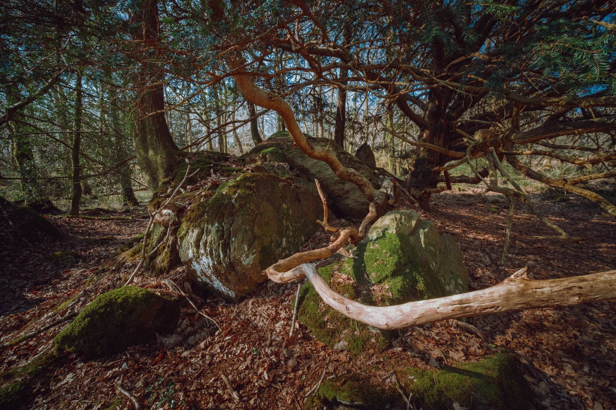
Upon entering the Woodland Trail the geography quickly changes from open bog to a limestone woodland. Lisabet and I spotted this otherworldly scene consisting of tree branches snaking around a limestone outcrop.
There were barely any clouds on our outing, allowing for the sun to penetrate through the canopy of the woodland.
More snake-like tree trunks and branches, with the addition of fungi, which Lisabet was happy to find.
This part of Roudsea Woods was a lot more green, and we were happy to see the beginnings of bluebells appearing on the woodland floor.
Just a moment, when the light caught only this tree.
Flora blossoming everywhere.
An early Bluebell. We’ll be seeing more of these in the various woods around Cumbria within the next fortnight or so.
A weird configuration of a limestone outcrop with a tree root system slowly enveloping it.
Tendrils of wood everywhere, gorgeous textures abound.
After completing the Woodland Trail, we joined the Cumbria Coast Way west towards the Levens Estuary. I knew there would be sand and mudflats ahoy as the estuary is linked to Morecambe Baby, but I had no idea there were these rocky outcrops along the coast.
I was transfixed when I saw these rocks and their beautiful lines, textures, and patterns. I had to come get some compositions in.
We were blessed with a rather beautiful, if hazy, day to be exploring this area of South Cumbria.
Looking back across Levens Estuary towards How Barrow and the Cartmel fells.
An almost impossibly perfect composition that I couldn’t resist on our way back to the car.
Lancaster Canal, Cumbria, Spring
Today was a little more low key.
Today was a little more low key.
The last time Lisabet and I walked the “Northern Reaches” of Lancaster Canal was back in May/June of 2020. You should check those posts out for more of the history of Lancaster Canal, with greater detail about the Northern Reaches.
After a day around Grizedale Forest, we felt a simple walk alongside some of the Northern Reaches of Lancaster Canal was in order. In particular, the section from Millness to Duke’s Bridge, with Farleton Knott in plain sight, is stupendously pretty. And the weather didn’t disappoint either.
All photos shot on my Fujifilm X-T2 using a Samyang 35mm f/1.2 lens with a Marumi Super DHG circular polariser attached. Developed using RNI’s Kodachrome film profiles.
If you ever want to take a boat to explore some of the abandoned Northern Reaches of Lancaster Canal, this is where you do it.
Glorious spring light bleeding through the trees. It’s lovely to see all the leaves on the trees starting to sprout.
Looking back the way we came.
Popping out of the more wooded section of Lancaster Canal reveals the unmistakeable presence of Farleton Knott (265 m/869 ft). Whilst certainly not a large hill, it is nevertheless a striking silhouette.
Closer to Duke’s Bridge, with some cyclists ahead enjoying the day.
Just… a lovely little scene.
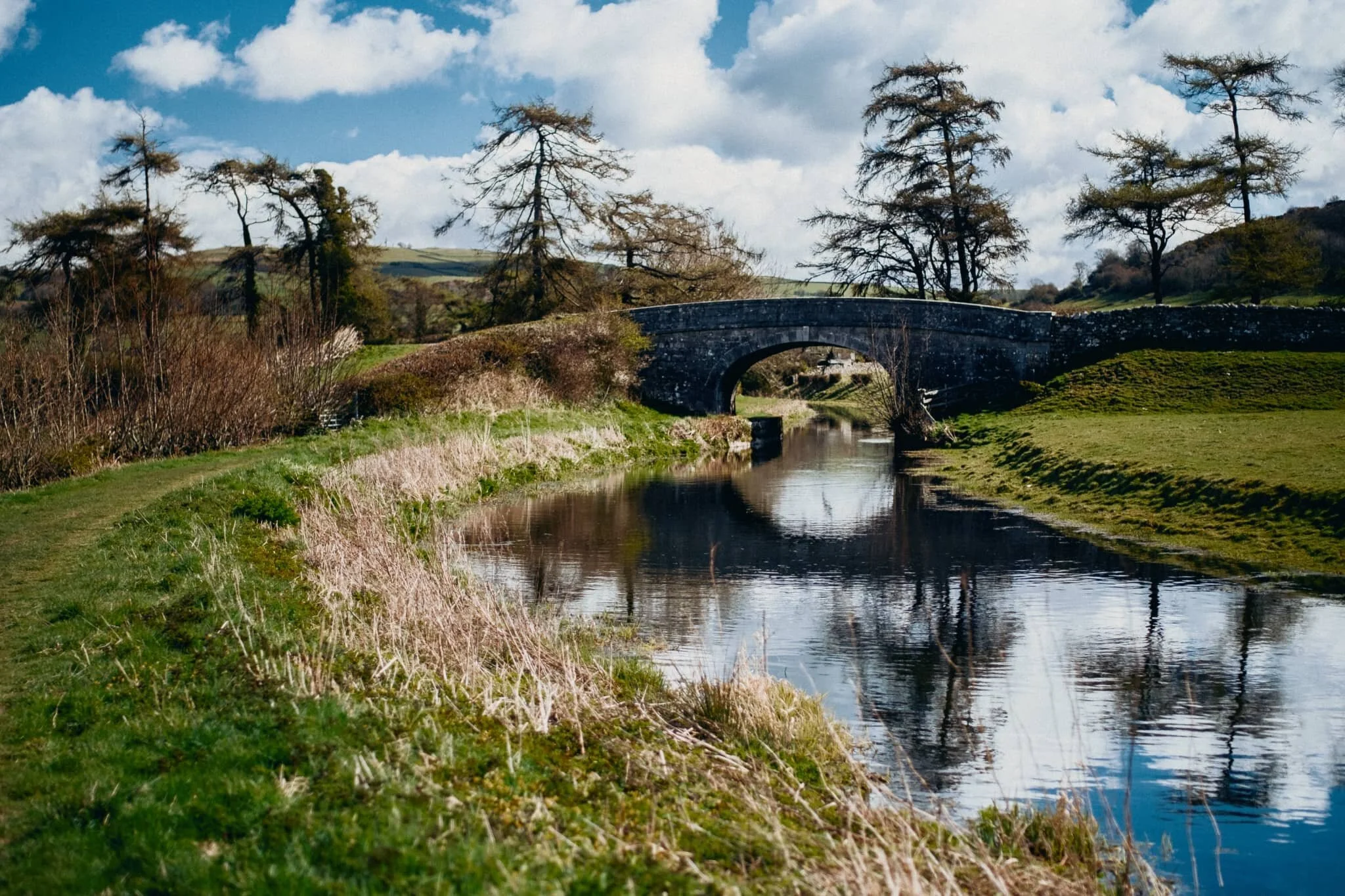
Farleton Turnpike Bridge (Nº 156) just before Duke’s Bridge, which signals the end of this section of the canal (and the path).
Hodgson’s Bridge, (Nº 157).
At Duke’s Bridge the canal opens out into a mooring/turn point area, allowing for some reflections of Farleton Knott.
Looking back all the way down the Canal path from near it’s terminus. Off-photo to my right, a pair of swans were busy building a rather comfortable-looking nest.
I can heartily recommend walking the Northern Reaches of Lancaster Canal for a non-taxing yet visually pleasing wander.