
The Quiraing, Isle of Skye, Scotland, Spring
It’s so hard to ignore the Quiraing when you’re on Skye.
It’s so hard to ignore the Quiraing when you’re on Skye.
Comprising the northernmost aspect of the Trotternish peninsula landslip, the Quiraing is a true marvel. It features sheer cliffs 150 m tall, emotive and otherworldly geological formations such as the Prison, the Needle, and Table, as well as individual peaks formed from ancient landslips such as Cleat and Bioda Buidhe.
We approached the Quiraing from two separate sides. On one day we took the short and steep route into the Quiraing via Flodigarry, the eastern side. On another day we returned and hiked the more conventional tourist route. Both offer equally astounding scenes.
One day, we’ll be able to walk the entire Quiraing, in all its treacherously steep glory.
All photos taken on my Sony α7ii using my Rokinon 14mm f2.8 ED AS IF UMC and Pentax SMC 28mm F3.5 prime lenses. RAWs developed in Lightroom, then edited and finalised in Photoshop.
The Quiraing, Isle of Skye, Scotland, Spring by Ian Cylkowski is licensed under CC BY-NC-SA 4.0![]()
![]()
![]()
![]()
The Quiraing from Flodigarry
At Flodigarry you can find a small car park, fit for 5 or so cars. From here it’s a simple walk to the first loch you’ll come across, Loch Langaig. Above the loch are the block-shaped crags known as Fingal’s Pinnacles, which includes Leac nan Fionn, or “Fingal’s tomb”.
Beyond Loch Langaig, the trail starts to quickly ramp up and you soon arrive directly beneath the impressive Fingal’s pinnacles. Below the pinnacles is Loch Hasco, which I cautiously clambered down to for this breathtaking composition.
We returned to the trail as it began its steep pull towards the cliffs of Meall na Suiramach, the highest peak of the Quiraing. From the side, the Pinnacles reveal a more slender profile that I couldn’t ignore.
Above Loch Hasco and beneath the cliffs of Meall na Suiramach, we took some rest and explored more fascinating rock formations. I found this weird nubbin of rock as the sun crested above the cliffs of the Quiraing.
The conventional Quiraing route
The more “tourist-friendly” way around the Quiraing has seen a lot of infrastructure improvements over the years, including a new car park at the top and better road surfacing. There’s also a new viewing platform, giving people an easy way to get these views.
Along the trail north, chunks of the edge of the Quiraing have been cordoned off due to unstable cliffs and to protect rare flora. From one vantage point, as the sun emerged, I nabbed this composition looking straight down to the valley floor, a mountain sheep looking back at me.
One of the classic views of the Quiraing. It’s been done numerous times, of course, and often better than what I can manage. Nevertheless, I refuse to let another opportunity pass by. It’s such a wonderful scene.
Did you enjoy these photos?

Sleat Peninsula, Isle of Skye, Scotland, Spring
Skye’s Sleat peninsula often gets overlooked.
Skye’s Sleat peninsula often gets overlooked.
It’s understandable why. When the island contains wonders such as the Cuillins, the Quiraing, the Storr, the Fairy Pools and more, why would you go to the extreme south/south-west of the island?
In my experience, Sleat is where you take photos from, not of. While the peninsula does have some lovely coastline, arguably it’s finest aspect is the views you can get from its southern and northern shores.
Looking south across the Sound of Sleat one can enjoy immense views of the Knoydart mountains, such as Ladhar Bheinn, Meall Buidhe, and Luinne Bheinn.
Over the peninsula onto its northern shores, Sleat harbours beautiful beaches and craggy coastlines, punctuated by bonny little crofting settlements, such as Tarskavaig, Tokavaig, and Ord. These places get unparalleled views across Loch Eishort towards the entire Cuillins range.
My advice: Give yourself a day to explore Sleat. You won’t regret it.
All photos taken on my Sony α7ii using my Rokinon 14mm f2.8 ED AS IF UMC and Pentax SMC 28mm F3.5 prime lenses, and my Vivitar “Series 1” 70–210mm f2.8–4.0 zoom lens. RAWs developed in Lightroom then edited and finalised in Photoshop.
Sleat Peninsula, Isle of Skye, Scotland Spring by Ian Cylkowski is licensed under CC BY-NC-SA 4.0![]()
![]()
![]()
![]()
Just north of Armadale there’s a stretch of coastline known as Bàgh a' Mhuilinn (“Bay of the Mill”). Here, one can play around with incredible rock formations and the Knoydart mountains in the distance.
The geology around Armadale is largely comprised of Lewisian Gneiss, which are some of the oldest rocks on Earth; roughly 3.0–1.7 billion years old! In the distance the main peak in the Knoydart is Ladhar Bheinn (“peak of the hoof”).
From near Armadale you can take the single-track winding road over the Sleat peninsula towards its northern shores. Along the way, though, magnificent views of the Cuillins reveal themselves. We stopped to nab some photos from above Loch Dhùghaill because who can say no to this?!
Arriving at Tarskavaig Bay, Lisabet and I quickly wandered off to explore and photography. I found this fascinating person-high crag on the beach, and clambered within its nooks and crannies looking for compositions. These are Lewisian Gneiss again, but have been squashed and stretched so much that they've become very fine-grained and have lots of cracks. They also have minerals like chlorite and epidote in them.
Away from the massive crag I head towards the more expansive beach, with fantastic clear views towards the Cuillins. I find another otherworldly rock formation and seek to compose along with the winding channels towards the Cuillins.
Moving on from Tarskavaig, we continue up the northern shore of Sleat to Tokavaig. At Tokavaig Bay, one can find the ruins of Dùn Scaich castle, formerly owned by Clan MacDonald of Sleat, a branch of the Clan Donald or MacDonald. With my long zoom lens, I can really compress the distant views, capturing the ruins of the castle as well as the mighty Blàbheinn mountain in the distance.
Dùn Scaich castle sits atop a crag on the Tokavaig coast, given near 360 views of its surroundings. It would’ve once been possible to enter the ruins across the arched footpath, but the floor of it has collapsed. The fortress is alternatively referred to as the "Fortress of Shadows." It is famously associated with the legend of the warrior woman Scáthach, who is said to have resided there, giving the castle its name.
Further long the coastline from the castle ruins are several sheer cliffs that offer unimpeded views across Loch Eishort to the entire Cuillins range. Here, my Lisabet stands perilously close to the edge of one cliff, providing a sense of scale.
The view you can enjoy from Tokavaig’s cliffs. The small trio of islands in the loch are called Eilean Ruairidh, translating as “Isle of the Red King”. There was once a fort here too. From this view, it’s clear to view the geological differences between the Black Cuillins, towards the left, and the Red Cuillins towards the right. The Red being smoother and made of granite, and the Black being more jagged and made of gabbro.
Further along the coastline we arrive at Ord, where one can take the minor road back over the Sleat peninsula to its southern shores. Before we did, we explored the bay here too. At Ord, you can find crags on the beach where old rocks meet some younger rocks called quartzites, and the younger rocks are found underneath the older ones, which is a bit unusual. The quartzites have some cool features, like cross-bedding (patterns in the rock) and folding (where the rock has been bent).
From Ord I once again equipped my 70-210mm zoom lens for some tighter compressed compositions. I lined up the small rocky islands just off the bay to lead towards the Strathaird coastline and Blàbheinn looming above everything.
Did you enjoy these photos?

Sligachan, Isle of Skye, Scotland, Spring
I have returned from my fifth visit to Skye.
I have returned from my fifth visit to Skye.
God damn I love that island so much.
What definitely helps, apart from the fantastic scenery, is that for entire week of our stay the weather and light conditions were fantastic.
All in all, I returned to Cumbria with 200+ RAW files of epicness. Where does one start?
For me, with one of my favourite places on Skye: Sligachan.
Sligachan is a small settlement on Skye’s eastern coast, somewhat halfway between two of Skye’s major population centres: Portree and Broadford. There’s not much at Sligachan apart from a hotel and a couple of houses. What it does offer is some of the finest views of the Black Cuillins and Red Cuillins on Skye.
In particular, there are a number of small rivers that run from the Cuillins towards Loch Sligachan, and the underlying geology has enabled some fantastic waterfalls. You’ve just gotta be prepared for some boggy hiking.
I’ve played around these waterfalls many a time, always seeking the “one” winning photo from this area. On this occasion, I’ve come closer than ever before of capturing that special photo from this magical place.
All photos taken on my Sony α7ii using my Pentax SMC 28mm F3.5 and Rokinon 14mm f2.8 ED AS IF UMC prime lenses. RAW files developed in Lightroom, edited and finalised in Photoshop.
Sligachan, Isle of Skye, Scotland, Spring by Ian Cylkowski is licensed under CC BY-NC-SA 4.0![]()
![]()
![]()
![]()
On our first full day on Skye, we first enjoyed the Scorrybreac circular around Portree. Afterwards, we nipped south to visit Sligachan. Whilst Portree was relatively sunny, conditions at Sligachan were significantly different. Stormy skies and powerful freezing winds made for some awe-inspiring conditions. On this occasion this was the best image I could make on this brief visit, the Red Cuillins topped in snow with storm clouds brewing above.
Returning to Sligachan on another day presented a completely different story, with strong sun bursting through the passing, racing clouds. Our first port of call was getting under the Old Sligachan Bridge for a composition of the Black Cuillins.
Afterwards, we began the hike up alongside one of Sligachan’s many rivers, this one being the Allt Dearg Mòr (“Great Red River”). Numerous waterfalls can be found along the river, this one being one of the bigger ones. My ultra-wide 14mm lens was able to capture not only the entirety of the falls and the snow-capped Black Cuillins, but some of the Red Cuillins too.
Beyond the large waterfall, a wide series of falls presented a beautiful composition involving the Black Cuillins as the clouds sank over the mountains.
Getting closer to the falls as I dared, I faced directly towards the sun and attempted a composition of the falls with one of the Red Cuillins, Marsco (736 m/2,415 ft).
A 3-shot 28mm panorama stack from top to bottom enabled this composition of another waterfall with the snowy Black Cuillins darkening above.
Looking back down the river towards the Red Cuillins saw clearer skies. On the left, the wizard’s hat of a mountain is Glamaig (775 m/2,543 ft), catching the light on its smooth flanks. The other Red Cuillin in the distance is Beinn Dearg Mhòr (731 m/2,398 ft)
Back at the Old Bridge, a classic composition involving the bridge and Glamaig proved impossible to resist. In the late 1800s a Gurkha named Harkabir Tharpa scaled Glamaig, starting and finishing at sea level in the bar of the Sligachan Hotel, in 55 minutes. That’s nuts, especially considering most routes up the mountain involved a steep climb on loose scree.
Did you enjoy these photos?

Hull Pot, Yorkshire Dales, Winter
A month since my last post.
A month since my last post.
I do apologise.
The weather in January has been, well, shocking to say the least. We endured three named storms: Henk, Isha, and Jocelyn. Isha, in particular, was one of the most powerful storms the British Isles have seen since 2000.
Additionally, we’ve had periods of below freezing temperatures, resulting in widespread ice.
It’s been… interesting.
Thankfully, the weekend just gone, it was nice enough for us to finally head out. We chose the Hull Pot route from Horton-in-Ribblesdale in the Yorkshire Dales. I had an inkling that there’d still be some snow liggin’ about in the Dales, contributing to a water-saturated landscape and, hopefully, a waterfall flowing into Hull Pot.
And we finally saw it.
All photos taken on my Sony α7ii using my Pentax SMC 28mm F3.5, Pentax SMC 55mm f2.0, and Rokinon 14mm f2.8 ED AS IF UMC prime lenses. RAWs developed in Lightroom, edited and finalised in Photoshop.
Hull Pot, Yorkshire Dales, Winter by Ian Cylkowski is licensed under CC BY-NC-SA 4.0![]()
![]()
![]()
![]()
The characteristic drystone walls of the Yorkshire Dales remained steadfast in the face of all the snow we’ve had recently, resulting in these snowdrifts piled up against them.
Our way forward. We knew on this day that there’d only be 2-3 hours of good light, and boy was it dramatic.
Looking back at where we came from. We were very much on the edge of two weather systems. Conditions over Horton-in-Ribblesdale saw blue skies and puffy clouds, but closer to Pen-y-Ghent it was blowy, dark, and stormy, giving us epic light.
A good sign: A small waterfall where there usually isn’t at Horton Scar. Above, Pen-y-Ghent fights with the dark and stormy clouds.
Further up the bridleway, the site of an extinct waterfall below Pen-y-Ghent, which is now obscured by clouds laden with snow. A burst of sun to our right picks out the details in the land.
And there she is, finally ticked off my bucket list. England’s largest natural hole, Hull Pot, with Hull Pot Beck tumbling down 60ft into the chasm. As mentioned before on this blog, Hull Pot is a large cave where the roof has collapsed, which has resulted in this massive chasm below Pen-y-Ghent. With my ultra-wide 14mm equipped, I was able to capture the entire scene.
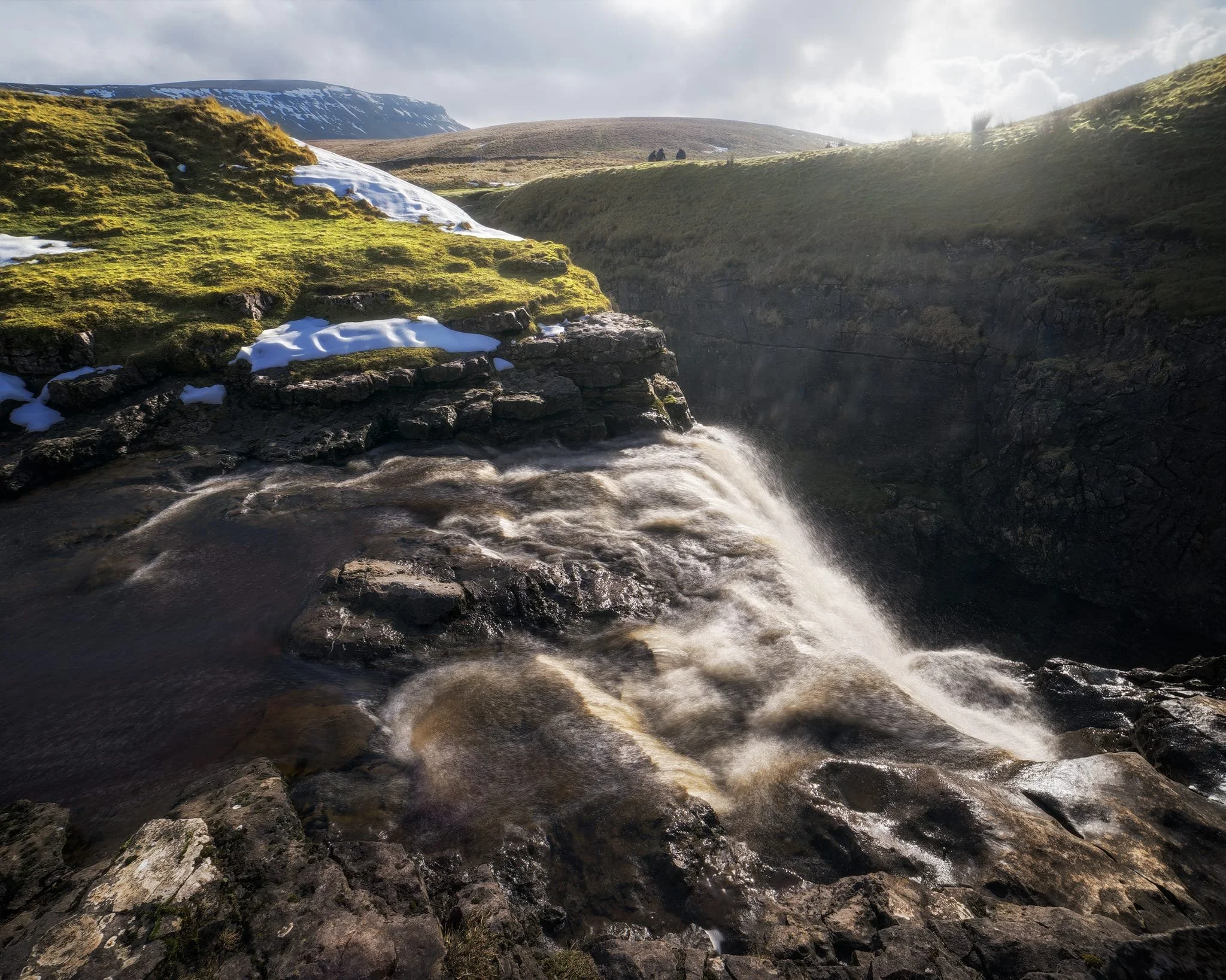
We clambered as close to the waterfall as possible as it crashed over the edge into Hull Pot. As I had no tripod, I shot this with my ultra-wide 14mm at f/22, taking multiple exposures of the same scene. In post, I then averaged the exposures together that gave me that long exposure effect on the water.
Looking up Hull Pot Beck and its many cascades. By the normal way of things, this beck is dry as it usually disappears into the maze of caves beneath Pen-y-Ghent before it reaches Hull Pot. With all the rain and snow we’ve had, the beck was able to complete its route, crashing 60ft down into Hull Pot and re-emerging at the surface nearer Horton-in-Ribblesdale.
A different view of Hull Pot from its eastern end. Two boulders balance precariously on the lip of the pot.
At around 450 m/1,476 ft above sea level, a few snow patches have lingered around the edges of Hull Pot, allowing for some interesting compositional leading lines.
A particularly clean snow patch nearer the falls gives me an idea for a composition involving Pen-y-Ghent in the distance. Fellow hikers milling about the edge of Hull Pot give you a sense of scale of this place.
Heading back down to the village, signs were clear that the best of the day’s light were done as the storm clouds rolled in. We were thankful to get what we did, though.
Did you enjoy these photos?
Durham, County Durham, Autumn
My first time in Durham.
My first time in Durham.
On the day of our anniversary proper, we woke up nice and early for a full day exploring the historical city of Durham.
I’d never visited the city before. Durham didn’t let me down. The day was bright and clear, bouncing golden light off Durham’s architecture, both modern and ancient.
Though our itinerary was kinda loose, a definite desire was to explore the epic Durham Cathedral, part of a UNESCO World Heritage site with Durham Castle.
Though our day was unfortunately cut short as I unexpectedly developed a stomach bug, what we did manage to see inspired to visit again.
All photos taken on my Sony α7ii using my Pentax SMC 28mm F3.5 and Rokinon 14mm f2.8 ED AS IF UMC prime lenses. RAWs were developed in Lightroom using Cobalt Image’s Sony profiles, with extra help from Photoshop and Photomatix.
Durham, County Durham, Autumn by Ian Cylkowski is licensed under CC BY-NC-SA 4.0![]()
![]()
![]()
![]()
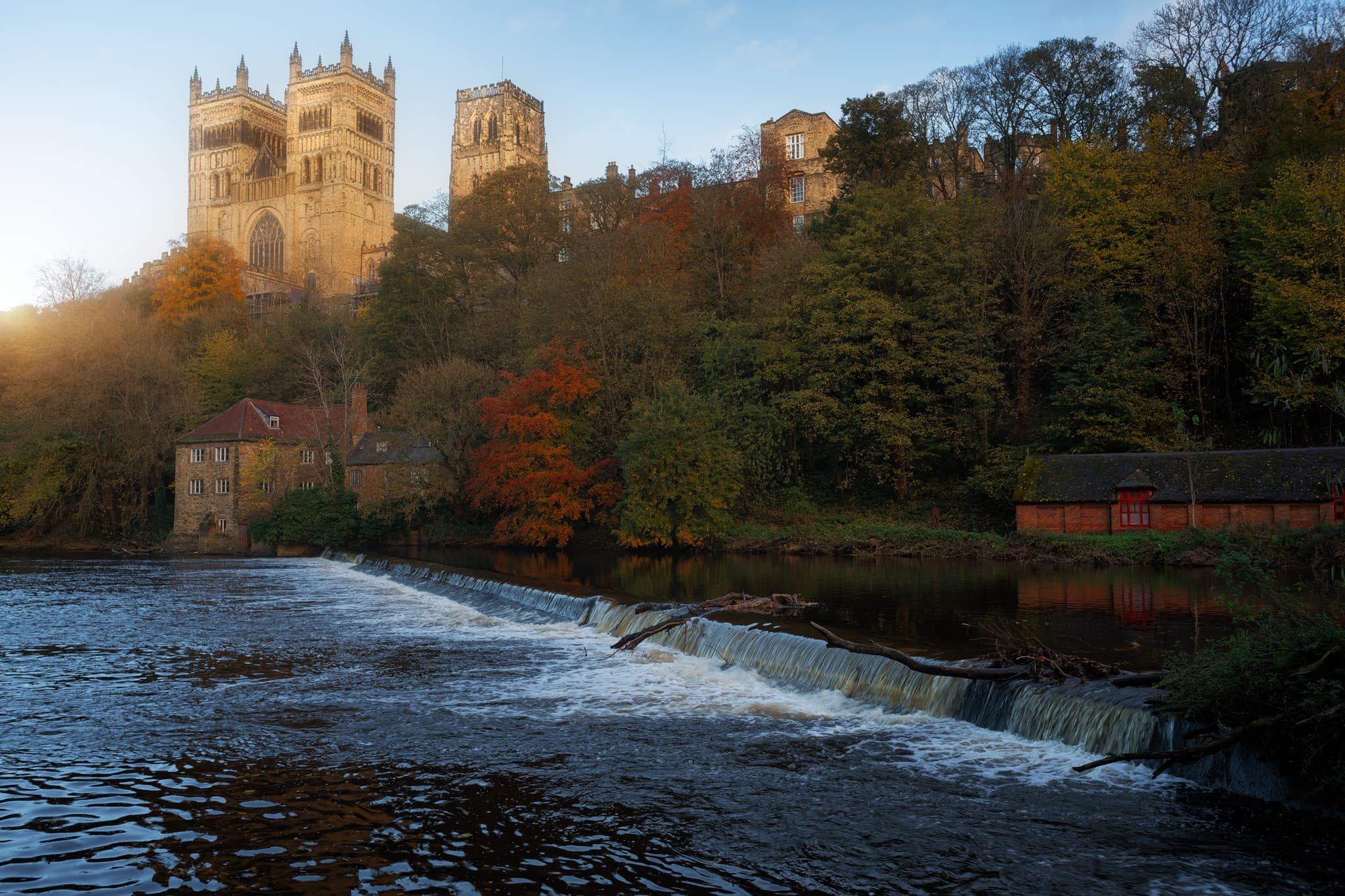
A weir at the River Wear. Clear and low autumnal light makes Durham’s buildings glow gold.
I moved into the shadows on Saddler Street, so I could pick out my compositions where the golden autumnal light was landing in interesting places. Saddler Street is one of Durham’s older roads, originally called Saddlergate.
Branching off Saddler Street is Elvet Bridge. There are numerous little “vennels”, or alleyways, that branch off Elvet Bridge. This was, Drury Lane, was home to a particularly picturesque cafe that we stopped for a brew at. I had to record this ridiculously timeless scene.
Soon we headed towards our main destination of the day: the massive Durham Cathedral, standing tall since the 11th century.
You enter the cathedral first via the Galilee Chapel. Constructed in 1170 CE, this part of the cathedral now serves as the resting place of St. Bede. Saint Bede (673-735) was an English monk and scholar renowned for his work Historia ecclesiastica gentis Anglorum, which provides invaluable insight into the history of Britain and the spread of Christianity among the Anglo-Saxon tribes.
After sorting out our entrance, we paid for the tower climb. Here you can ascend all 325 steps, 218 ft, to enjoy some immense views over Durham. I felt like a drone taking these photos! This is the view looking east.
The other side of the Central Tower gave us more extensive views looking west, pops of autumn colour here and there.
The nave of the cathedral, with its central ribbed vault obscured by the lighting fixtures assembled for an upcoming light show. The nave wouldn’t have looked much different compared to 900 years ago, except their wouldn’t be any seating.
Home to the Cathedra, the choir stalls, the organ, and the high altar, the Quire is where daily worship takes place.
This is the South Transept, from where you would access the Central Tower and climb its 325 steps. It features the Prior’s clock, constructed by Prior Castell in the late 15th or early 16th century.
The High Altar in the Quire. This would’ve been one of the earliest parts of cathedral to be constructed. Monks in the 11th century were seeking a place to hide from Vikings raids as they carried the relics of Saint Cuthbert.
The Chapel of the Nine Altars, built in the 13th century to accommodate the increasing number of pilgrims visiting the cathedral. Since St. Cuthbert’s shrine was seated here, Durham Cathedral has been an important place of worship for Christian pilgrims for centuries.
The Bishop’s Throne, built by Bishop Thomas Hatfield in the 14th century, with his tomb below it.
The light and stained glass windows around the Chapel of the Nine Altars was just astounding.
From around the Cloister, made more famous in modern times as one of the filming sets in the Harry Potter movies.

This is the Monks’ Dormitory, completed around 1404, and nowadays is home to the Cathedral Library, part of Durham Cathedral Museum. This was originally built as sleeping quarters for the Durham Priory monks.
The museum was truly fascinating and, much like the Faith Museum in Bishop Auckland, contained artefacts of faith and religious importance in the area from beyond Roman Times. This place lead to the Great Kitchen, which now houses a sacred part of the museum: Saint Cuthbert’s treasures and coffin.
Kingsgate Footbridge, completely resplendent in autumn colours. Our next goal was to locate the riverside footpath and take a wander along the river bend.
University boat racing was alive and well on the river as the sun began to set.
The woodland deep in the gorge was filled to the brim with incredible autumn colours.

From Prebends Bridge, the boat racing was in full flow, surrounded by vivid autumn foliage.
Putting Prebends Bridge in context of the river, the setting sun bursting from just above the trees.
And finally, Durham Cathedral from the riverside, catching the last of the light and glowing bright.
Did you enjoy these photos?
Bishop Auckland, County Durham, Autumn
An anniversary break.
An anniversary break.
Celebrating 11 years together, Lisabet and I enjoyed a lovely short break in County Durham area.
It’s a part of northern England that I guess can feel neglected or forgotten about. To the northwest you have the North Pennines and southwest are the Yorkshire Dales. Southeast is the North York Moors and further Northeast is the coast and Newcastle-upon-Tyne.
But there is an enormous amount of history in County Durham.
We stayed in Bishop Auckland, 10-minutes away from Durham. Bishop Auckland has a lot to offer, especially with the ongoing improvements courtesy of the ambitious Auckland Project. Upon arriving on the outskirts of the town, we head straight for its historic heart and took to exploring the Auckland Tower, the new Faith Museum, and the grounds of the castle.
We barely scratched the surface. But the just means more to explore for next time.
All photos taken on my Sony α7ii using my Pentax SMC 28mm F3.5 and Rokinon 14mm f2.8 ED AS IF UMC prime lenses. RAWs developed in Lightroom using Cobalt Image’s Fuji Classic Neg profile.
Bishop Auckland, County Durham, Autumn by Ian Cylkowski is licensed under CC BY-NC-SA 4.0![]()
![]()
![]()
![]()
Bishop Auckland Town Hall, with its unusual French-style mansard pavilions. It was opened in the mid-19th century, but by the 1970s it was abandoned then scheduled for demolition in the 1980s. Local campaigning saved the building and, after restoration work, it was reopened in the 1990s.
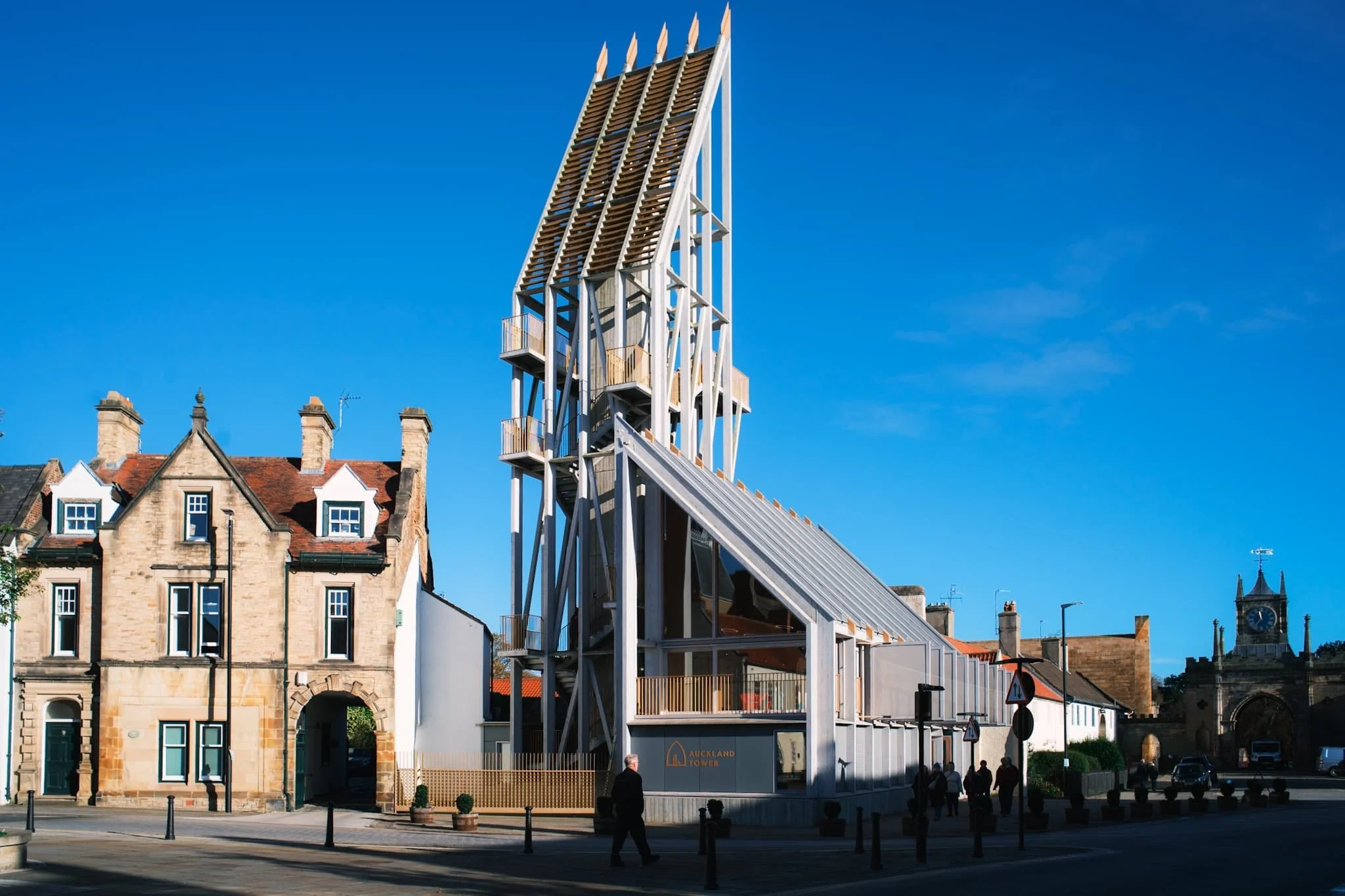
One of the new striking buildings courtesy of the Auckland Project. This is Auckland Tower. Its design is inspired by medieval wooden siege engines, which were propped against castle and fort walls to help invading armies breach defences. Adopting and inverting that same intention, the Auckland Tower borrows the design of those historic constructs to allow visitors to “breach” the castle’s history and allow people to freely explore.
A gallery on the 1st floor of the tower beautifully sets out the story and history of Bishop Auckland the surrounding area. The town was the seat of the powerful Prince Bishops of Durham since 1183 CE. Even before then, a Roman presence was in the area with a fort at nearby Binchester.
Visitors are encouraged to climb up the tower and enjoy the panoramic views on offer, which we duly did. St. Anne’s Church and the Town Hall are on the right, with the town centre through to the left.
From the top of the tower, a view to the east shows the castle gatehouse, built by Sir Thomas Robinson of Rokeby for Bishop William Trevor in 1760 CE. Beyond, the walled gardens and Auckland Park show the last of their autumnal splendour.
The grand entrance to the grounds of Auckland Castle. Inside the castle we paused for lunch in the new cafe, before seeking out the new Faith Museum.
The start of the journey into the Faith Museum. This place is fantastic, a real treasure for history geeks everywhere especially those who have an interest in the history of human faith. Being in County Durham, there is of course a lot of information about the beginnings and development of Christianity in the area, but there’s also heaps of artefacts and info about faith practised in the area during Roman times and before.
Punctuated along the main gallery were these wonderful archway tapestries that I couldn’t resist making a composition of.
Back outside, we soaked in the clear autumn air and explored the castle grounds.
We wandered around the town centre, where a different side of Bishop Auckland could be seen. Much like many other towns through the UK, the high street has seen better days. Hopefully, the Auckland Project will help rejuvenate things.
I love a pub with a mock Tudor facade. Though a pub has been on this site since the 16th century, this particular building was constructed in 1900.