Morecambe & Heysham, Lancashire, Summer
After a thunderstorm, you need to get those vast and expansive views.
After a thunderstorm, you need to get those vast and expansive views.
On the Saturday, the Met Office issued a Yellow Warning of thunderstorms and torrential downpours. This was very much needed as temperatures were starting to creep up to the mid 20’s again with 90%+ humidity.
If there’s one thing a thunderstorm is really good at it’s clearing the atmosphere. So, on the Sunday, we decided that solid hike along the Morecambe Bay coast, from Morecambe to Heysham and back, was needed. The views across the bay to Cumbria and the Lake District fells are always welcome. Plus, we knew we would have limited time before the next load of thunderstorms arrived.
I decided to equip relatively minimally; just my camera, Sony 28–70 and Vivitar “Series 1” 70–210mm for those super tight and zoomed in compositions.
The views, and the weather, were glorious.
All photos taken on my Sony α7ii using my Sony FE 28–70mm f3.5–5.6 OSS and Vivitar “Series 1” 70–210mm f2.8–4.0 zoom lenses. RAWs developed in Lightroom for iPad using RNI Films’ Portra 160 film emulation, then a little bit of finalisation in Affinity Photo 2 for iPad.
Morecambe & Heysham, Lancashire, Summer by Ian Cylkowski is licensed under CC BY-NC-SA 4.0![]()
![]()
![]()
![]()
Want sweeping and expansive views for mountains in the distance? Morecambe Bay is where you need to be. Anywhere with access to the Bay will do, but for this walk we chose the town of Morecambe itself.
This is the 14 m tall Hook Beacon, signalling the location of West End Gardens at Morecambe Bay. It was conceived by Broadbent Studio in collaboration with local school pupils.
A man and his dog, watching the world go by.
We started the walk 1-hour after low tide, so the sea was still miles out. Families and couples alike were enjoying the sensation of wet sand on their feet and sea air in their faces.
I decided to equip my 70–210mm lens for some super-zoomed in compositions across the bay to Cumbria.
A lovely mural that I can never resist taking a shot of.
Nice and clear, the Coniston Fells in the Lake District, 25 miles away.
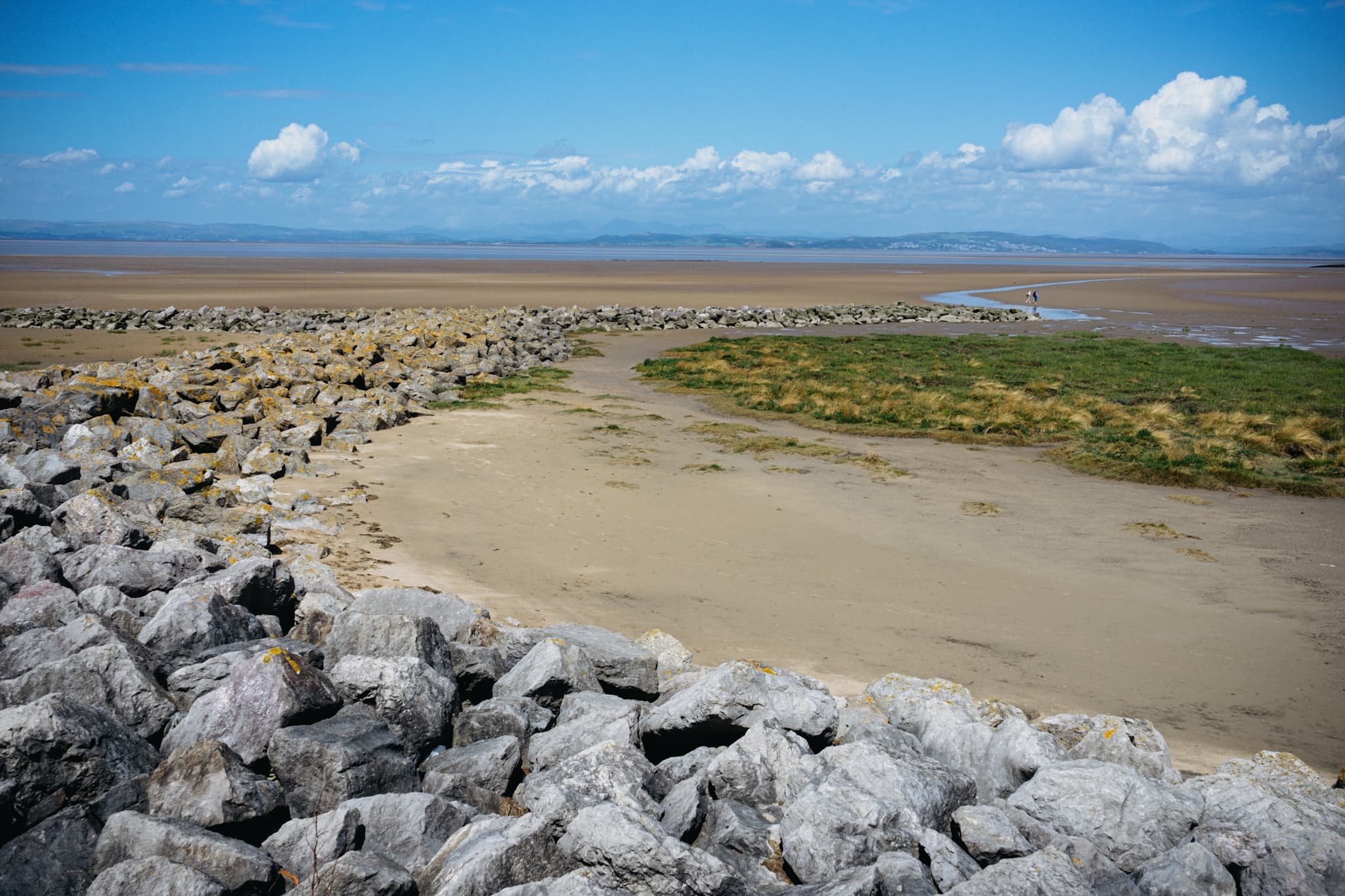
One of numerous breakwaters along Morecambe. This is Grosevenor Breakwater, with Black Combe (600 m/1,970 ft) rising in the distance.
It’s always nice to see people soaking in the vibes of the day and taking in the immense views that Morecambe has to offer.
South beyond the town of Morecambe, ancient Heysham comes into view, resting on a small hill above the Bay.
St. Peter’s church. Christian worship has been regularly practised at the site for over 1,000 years.
The graveyard behind the church enjoys spectacular views across the Bay.
Trees in the graveyard remind us of the passing of time beyond our own horizons.
The ruins of St. Peter’s chapel, dating from around the 8th or 9th century. It gives me vibes of a portal to another world.
A group of six stone-hewn tombs dating from around the 11th century. Each tomb has an associated “socket”, which was probably where a wooden cross would be inserted.
At Half Moon Bay, just before Heysham Nuclear Power Station, one can find the marvellous SHIP sculpture by Anna Gillespie.
The ship's hull is mounted with two opposing figures at each end. One faces "new" Heysham, the Nuclear Power Station, and the other faces "old" Heysham, the ancient monument of St Patrick's Chapel.
The sculpture "celebrates Morecambe Bay's landscape and maritime heritage, and reflects the importance of seaborne trade in bringing news, innovation and shaping the character of the area."
Heading back to Morecambe, I couldn’t resist nabbing the colour contrast of pink and green courtesy of these flowers.
The way back to Morecambe, with plenty of other peeps enjoying the day out in the glorious sunshine.
This gentleman was raising people’s spirits with tunes from his pocket trumpet. He was also kind enough to pose for a photo or two and give us a rendition of “Bring Me Sunshine”, an appropriate tune for the town of Morecambe.
Did you enjoy these photos?

Mallerstang & Smardale, Cumbria, Summer
The British summer heatwave has arrived.
The British summer heatwave has arrived.
I took the opportunity for a long overdue stay over at my Dad’s, so that we could enjoy a lovely wander in the glorious British sunshine during the weekend.
After considering the potential busyness of the Lake District and Yorkshire Dales, we agreed to two outings: the first in the beautiful Mallerstang valley, and the second in Smardale.
Technically Mallerstang falls in the Yorkshire Dales these days, but it is often ignored in favour of some of Dales’ more popular southern hotspots. Smardale, especially Smardale Gill, is a remote and deep valley just outside Kirkby Lonsdale. It features a gorgeous viaduct crossing the valley, the Smardale Gill Viaduct.
In between each excursion, we visited Kirkby Stephen for delicious food.
A crackin’ weekend.
All photos taken on my Fujifilm X-T2 using my Vivitar “Series 1” 28–105mm f2.8–f3.8 zoom and my Laowa 9mm f/2.8 prime. RAWs developed in Capture One for iPad, finished in Affinity Photo.
Mallerstang
Parking up near Aisgill in Mallerstang, I can never ignore this road’s view towards Wild Boar Fell.
Not a bad view if you’re on the Settle–Carlisle line, eh?
Our goal on this hike around Mallerstang was to get onto the Pennine Bridleway and eventually towards the Water Cut sculpture. Along the way, we diverted to get a view of Hell Gill Force, which with the lack of rain looked rather pitiful.
Happy cows staring quizzically at us from across the beck.
A dry Hell Gill Beck reveals the riverbed formations its been carving. Further up the beck as you go up the fellside, the river has cut an impressive gorge that I’d like to explore one day.
Various parts of the Mallerstang valley have been fenced off from livestock, allowing meadows to flourish full of flowers.
Up on the Pennine Bridleway! This is a section of the bridleway known as A Pennine Journey, once walked and described by famed walker Alfred Wainwright.
An oystercatcher (Haematopus ostralegus), unusually high up and inland compared to its preferred breeding grounds near the coast.
As well as oystercatchers, and plenty of sheep, circling above us were Northern Lapwings (Vanellus vanellus), noisily warding us away from their chicks/nest.
Our destination comes into view, and the panorama starts to open up.
This sculpture, found on the Pennine Bridleway, is called “Watercut” by Mary Bourne. The watery gap that divides the sculpture utilises the changing sky to echo the ever-changing flow of water.
It’s hard to resist playing with the cut for photographic compositions.
Across the valley, Wild Boar Fell rises steeply into the sky at 2,323 ft (708 m) high.
The Pennine Bridleway continues down the valley, with Mallerstang Edge above. We elected to trace our footsteps back to the car.
Swarth Fell and the many gills that cut into its fellside.
Smardale Gill
After refuelling with drink and food at Kirkby Stephen, we parked up at Smardale to walk through the nature reserve towards the epic Smardale Gill Viaduct.
Flies followed and pestered us all the way. Nevertheless, Dad managed to spot and nab a superb photo of a toad, and we finally reached the viaduct, granting us views such as this.
Smardale Gill Viaduct was built in 1861, crossing the Pennines to carry coke to the iron and steel furnaces in the Barrow area and West Cumberland. It carried the railway 90 feet (27m) high above the valley and was constructed of locally quarried sandstone. The viaduct has 14 arches of 30 feet span, and a total length of 553 feet (c170m).
High above us, passing clouds created gorgeous gradients of light and shadow across the fellsides.
In the distance is Green Bell, one of the Howgills near Ravenstonedale.
The line was closed in 1962, after British steelmaking finished. For over twenty years the viaduct stood disused, deteriorating from lack of maintenance and exposure to the weather. British Rail wanted to demolish it but instead Eden District Council listed it. In 1989 the Northern Viaduct Trust was setup and in the Autumn of 1992 it was formally handed over to the Trust as a permissible footpath. It has required repair work numerous times since, and still does.
Did you like these photos?
Mallerstang & Smardale, Cumbria, Summer by Ian Cylkowski is licensed under CC BY-NC-SA 4.0![]()
![]()
![]()
![]()
Coldstones Cut & Almscliffe Crag, North Yorkshire, Spring
Yorkshire’s a beautiful county, isn’t it?
Yorkshire's a beautiful county, isn't it?
Living in Kendal as we do, we enjoy closer access to the Yorkshire Dales, an area in North Yorkshire we love dearly. But there's plenty more outside of the Dales.
Pateley Bridge, where we stayed at recently, is situated in the Nidderdale AONB, which lies outside of the Yorkshire Dales National Park. It's a stunning area in its own right. A 10-minute drive west of Pateley Bridge takes you up onto the moorland where can visit the incredible Coldstones Cut construction.
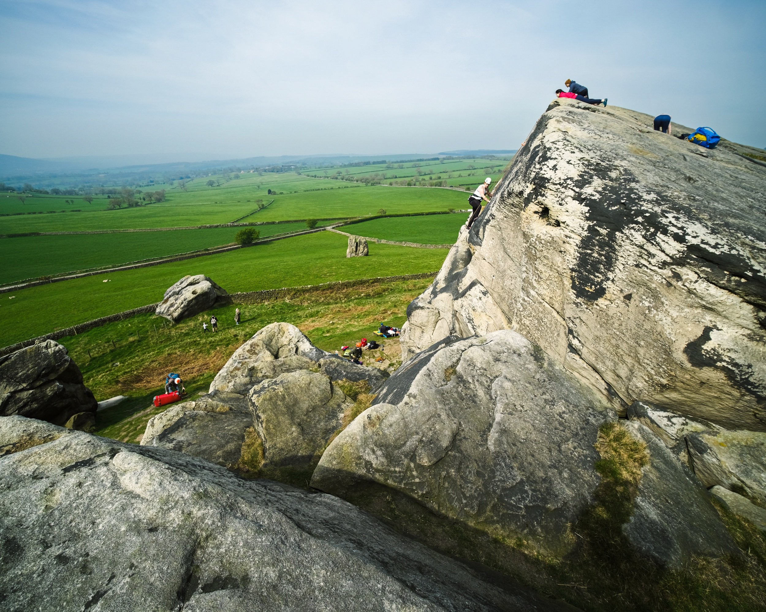
Further south of Pateley Bridge, near North Rigton, one can find the impressive Almscliffe Crag, a cap of millstone crags and rock formations sitting on top of a small hill. It's popular with rock climbers and boulderers, not to mention a walker's paradise.
On this particular occasion, we visited both areas on a beautiful yet hazy spring day.
All photos shot on my Fujifilm X-T2 using my three prime lenses: a Fujinon 23mm f/2.0, a Laowa 9mm f/2.8, and an adapted Pentax SMC 55mm f/2.0. Images made 80% in-camera using the Astia film simulation, then finished off in Lightroom and Affinity Photo.
Coldstones Cut
The entrance to Coldstones Cut, 400m above sea level.
Looking back down the "street" entrance of Coldstones Cut, the sun beaming right at us. Lisabet decided to go full Instagram Mode.
A 5-shot panorama of the view from one of the many view areas at Coldstones Cut. The construction overlooks the imposing Coldstones Quarry, the last remaining quarry in the area that was once dominated by a multitude of limestone quarries. It's estimated the quarry has 15-20 years of productivity left, after which it will be left to green over and return to nature.
Beneath Coldstones Cut and its quarry one can find the ruins of Toft Gate lime kiln. Limestone dug from the hill above was heated by fires in the kiln to produce quicklime for local agriculture through the 19th Century.
Almscliffe Crag
After exploring Coldstones Cut and appreciating the art and views, we ventured south near North Rigton. Here one can enjoy quick access to the imposing Almscliffe Crag.
Though not that busy, and certainly not in Lake District terms, there were still plenty of people milling around the crags. Mostly rock climbers.
Crags and rock formations like these inspire me to whip out my 9mm ultra-wide lens for some unusual and fantastical compositions.
As the crag is made of harder millstone rock, the hill it sits on is isolated from the rest of the land. This helps offer extensive and panoramic views, no matter where on the crags you are.
I appreciated the grit and determination of these rock climbers. I certainly couldn't do it.
Leading lines, curves, and textures ahoy. My happy place.
Lisabet and I clambered around the various nooks and crannies in between the crags, finding interesting views and compositions to photo.
I enjoy getting into precarious situations for those "hard to find" compositions and views.
I shot this primarily for the way the rocks seem to point at the road, which then zigzags off into the distance.
Directly beneath the crag that marks the highest point of the hill.

On the top, the crags have been smoothed out by millennia of erosion from wind and rain.
People cherishing the experience and moment in their own way from the top of Almscliffe Crag.
It's all starting to look beautifully verdant.
A couple and their pooch enjoy the summit views that stretch out for miles and miles.