Castles & Circles, Northumberland, Summer
This might be a bit of a mish-mash of a post, so bear with me.
This might be a bit of a mish-mash of a post, so bear with me.
One morning, whilst perusing our favourite weather apps and services, we could see that we needed to stay away from the coast if we wanted to avoid the rain and thunder. Being more in-land would be a better deal. So we began looking at our “wishlist” of Northumberland in-land locations and realised that quite a few of them were fair clustered together.
A plan formulated in our heads…
Now, each location here could well have been given its own post. But they would’ve been short posts, and I like giving value for money. So please enjoy this journey through the history, and pre-history, of Northumberland.
All photos taken on my Fujifilm X-T2 using my three prime lenses: a Samyang 35mm f/1.2, a Laowa 9mm f/2.8, and an adapted Pentax SMC 55mm f/2.0 lens. Images made 80% in-camera using a customised Velvia film simulation, with minor corrections and edits in Lightroom and Affinity Photo afterwards.
First stop, Norham Castle! The original tower known as the Great Tower, which is largely what’s left of the castle, was founded by Ranulf Flambard, Bishop of Durham, between 1099 and 1128 AD. It was built to protect the bishopric of Northumberland from the Scots.
That makes Norham Castle over 900-years old! The castle was an important fortification and site against the Scots, and in the course of the next 300 years since its founding the castle was attacked, invaded, and changed hands many times between the English and the Scots.
As peace finally settled between England and Scotland in the 16th century, Queen Elizabeth declared she would spend nothing on Norham and the castle was left to ruin.
It gained fame once again in the 19th century due to the paintings of J. M. W. Turner.
Here I employed some actual HDR photography, first time in many years, in an attempt to capture more dynamic range looking up the stairwell in the Great Tower.
The site and castle is now taken care of by English Heritage, who’ve made access to the area free and have helped maintained accessibility of this historic treasure.
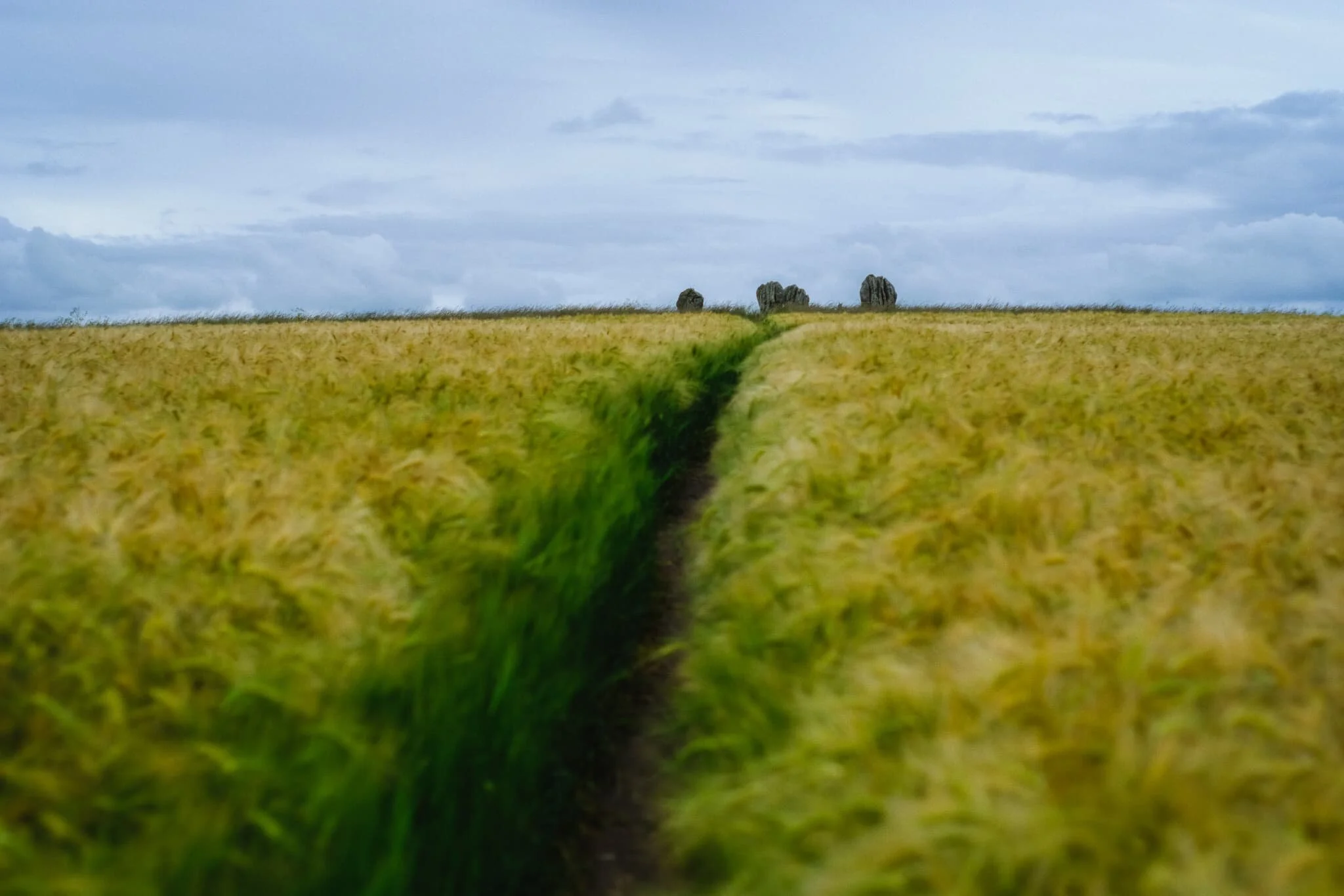
10-minutes south-by-southeast of Norham is the tiny village of Duddo. We parked up at a lay-by just outside the village to take the farmer-permitted access track to Duddo Stone Circle. The land around here seemed primarily used for growing crops of wheat, and their sea-like wavering in the wind mesmerised me.
Halfway along the path the stone circle becomes visible and we could see we weren’t the only ones. Lisabet and I waited by a clearing to give the previous visitors space to leave. One way in, one way out.
Looking back the way we came, the Cheviot Hills were looking rather lovely. Not as lovely as my Lisabet, though.
Our turn up the access track towards the stone circle. Our excitement builds.
And here we are, Duddo Stone Circle. Much more impressive than we had first anticipated, actually! The stone circle is “officially” known as Duddo Five Stones because, well, there’s five stones.
It was previously known as Duddo Four Stones, or just Four Stones, until 1903, when the fifth stone was re-erected to improve the skyline. The evidence, though, indicates that there were originally seven.
The stones are made of local sandstone and are deeply fissured due to weathering, making these incredible shapes. The best guess is that they were erected in the Early Bronze Age, so around 4,000 years ago! Which is crazy to think of.
Duddo Five Stones is located on a small hill north of the village of Duddo, and thus they offer panoramic views of the Cheviot Hills to the south and the Lammermuir Hills to the north. In view in this composition are the Cheviot Hills.
After soaking in the atmosphere of this mystical place, we eventually trundled our way back the same route to the car, drinking in the panoramic views as we did. A humbling place.
Another 4-minutes south of Duddo is the one-street village of Etal! Featured here is Northumberland’s only thatched-roof pub, The Black Bull. The whole village, in fact, was just impossibly idyllic and so very English.
We paused for lunch at Etal’s tearooms, enjoying the peace and all the little birds flitting about. A perfect Summer’s day in England.
Just a few doors down the street from The Black Bull is another cottage with a thatched roof. And a ridiculously pretty front garden.
Our destination at Etal was the castle, Etal Castle, which is what the village is centred around. Like Norham, Etal Castle is managed by English Heritage, only here you normally have to pay. On this occasion, due to the COVID-19 Pandemic, the visitor centre was not staffed so access to the site was free.
Similar to Norham Castle, the castle here at Etal saw a lot of conflict between the English and the Scots. It was built around 1341 AD by Robert Manners and after 200-years of cross-border conflict it was recaptured by the English Crown in 1547 AD. In 1603 AD it was abandoned as a military fortification, and eventually fell into ruin as the Union of Great Britain meant its original purpose was redundant.
What survives of the site these days is this gatehouse, a corner tower, and the residential tower, all of it constructed from local sandstone.
Another 5-minutes southeast of Etal is its “sister” village, Ford. It’s name could come from the shallow crossing of the River Till (known as a ford) that monks and nuns would use to navigate between the Iona and Lindisfarne monasteries.
One of Ford’s most famous residents was Lady Louisa Beresford, Marchioness of Waterford. She was a gifted amateur watercolorist and had enormous compassion and welfare for the tenants in her estate.
She had a school built in the village and, between 1860 and 1882, decorated it with wall paintings she created of bible scenes featuring local tenants, workers, and children in the scenes.
St. Michael & All Angels Church in Ford enjoys wonderful views towards the Cheviot Hills. There’s been a house of worship on this site since the 13th-century.
The imposing entrance to Ford Castle, built in 1287 to protect the manor of Ford from the battles between England and Scotland.
Lady Waterford’s grave. It was designed in 1891 by esteemed British painter and sculptor George Frederic Watts, and the slab was done by Watts's wife Mary Seton Watts.
In 1513, James IV of Scotland made Ford Castle here his base just before the Battle of Flodden, the largest battle between the Kingdoms of England and Scotland. He lost his life in the battle along with 9,000 of his men. Nowadays the castle is owned by the Joicey family, but has been leased to Northumberland County Council since 1956 as a Young Person’s Residential Centre.
At this point of the day we realised that conditions were much better on the coast of Northumberland than we had anticipated. Deciding to keep in the theme of history, we checked tide times and crossed the tidal causeway to the Holy Island of Lindisfarne.
The imposing castle of Lindisfarne, built in the 16th-century, perched atop a mound of whinsill rock known as Beblowe Craig. Turned out to be a glorious day indeed!
As the tide was out, Lisabet and I quickly made our way to the bay west of Lindisfarne Castle known as The Ouse.
I remembered a bunch of magnificently-shaped boulders along the coast from our last time here, way back in 2013.
Time to get the 9mm ultra-wide lens out for some near-far compositions of these boulders and Lindisfarne Castle!
Though Holy Island is tidal and largely made of mudflats, sand dunes, and salt marshes, there’s also a good chunk of volcanic rock, especially around the southeastern part of the island.
Well this was a lovely find on the way to Lindisfarne Castle! A vibrant crop of common mallow (Malva sylvestris), providing wonderful foreground interest in this composition of Lindisfarne Castle.
We’d never explored much of Holy Island on previous visits, preferring to focus on the castle, priory and village. This time, with newfound fitness, we went much further and followed the eastern shoreline towards the northeastern point of the island.
Emmanuel Head, the northeastern edge of England. The strange structure here isn’t a weird lighthouse but rather a daymark for maritime navigation. Standing 35 ft high, it was built in 1810 and is probably Britain’s earliest daymark.
On our trek back to the car, I snapped one final look up at the mighty Lindisfarne Castle. What a day.

Isle of Arran, Scotland, Autumn 2017
Here’s one from the archives.
Here’s one from the archives.
Back in September/October 2017, Lisabet and I took a 2-week holiday and split it into two. The first week was spent around the coast of the Scottish Borders, centred around Cove Harbour. The second week we crossed Scotland east to west and took a ferry over to the Isle of Arran.
It was our first, and only, time on this island, and we instantly fell in love.
Arran is often referred to in literature as “Scotland in miniature”, as the island can be split into the lowlands and highlands, much like mainland Scotland.
The Isle of Arran is well-known for many things. Of note, it’s home to one of the most recognisable mountains in Scotland, Cir Mhòr (799 m/2,621 ft, meaning “the big comb”). Arran was also where, in 1787, geologist James Hutton found his first “unconformity”. This provided evidence for his Plutonist geological theories and gave him a better idea about the age of the Earth.
We spent a solid week exploring and getting to know as much of the island as possible. I know personally I’d love to go back.
All photos shot on my camera at the time, which was a Sigma dp0 Quattro with built-in 14mm f/4.0 lens. I utilised a variety of graduated neutral density filters plus a polariser to control exposures. Developed using one of RNI’s Kodachrome film profiles.
On the first afternoon/evening on the island after crossing via the ferry, we went for a wander around Merkland Point, near Corrie on the east coast of Arran. I had previously learned about the weird and wonderful geology and rock formations on this piece of coastline, and I was not disappointed.
I loved the maze of patterns created by the grass and rock pools at Merkland Point. I framed this composition to fully fill up the frame with these patterns, set against Holy Island in the distance. We enjoyed a gentle sunset that evening, full of pastel pinks.
Some of the boulders around Merkland Point were covered in the most vivid moss and lichen I’ve ever seen. Truly otherworldly.
A closer composition of some of the moss and lichen found on the boulders around Merkland Point.
The next day we explored Arran’s southern coastline around Kildonan. This is another area you should check out if you’re into strange rocks (and are a bit of geek, like me). In the distance you can just make out Pladda, an uninhabited island south of Arran with its own automated lighthouse. Even further behind you might barely be able to see the pointy profile of Ailsa Crag, another uninhabited island in the Firth of Clyde.
I remember it was an incredibly blustery day. These were the days when I shot on a tripod all the time, and I remember having to brace myself against the tripod in order to hold it still enough for these exposures.
When we ventured back northwards along the southeastern coast of Arran, we stopped at Whiting Bay. There was a walk we knew of that took you to see a rather splendid waterfall. After a fairly strenuous hike, we finally arrived at the viewing point and were absolutely floored by the sight of one of the largest British waterfalls I’ve ever seen. This is Glenashdale Falls, dropping in two stages by around 140 ft. Even with a 14mm lens, I had to shoot three landscape images and stitch them top to bottom in order to fully show the scale of waterfall. Crazy.
We did have to contend with a full day, maybe two, of non-stop rain. But we ventured whenever we could spot gaps in the downpour. This is a composition from the spit of land that protrudes into Loch Ranza, northwest Arran. The hill featured in the centre is Tòrr Nead an Eoin (325 m/1,066 ft, meaning “crag of birds nests”)
One of the finest compositions I managed to nail in my time on the island. This is North Glen Sannox, looking towards the back of Cir Mhòr and Caisteal Abhail (859 m/2,818 ft, meaning “stronghold of the ptarmigan”). Our hike up this valley was frequently interrupted by passing squalls, but it was so windy that we knew we just had to wait it out and the rain would quickly move on.
Further down the foot of North Glen Sannox I nabbed this simple composition of the cascades of North Sannox Burn, with Sail an Im (508 m/1,666 ft) rising in the distance.
Near the start of the walk I took this composition which showcased some of the cascades and vivid rocks of North Sannox Burn.
Another location on our Arran “bucket list” was the Machrie Moor Stone Circles. These are a collection of six prehistoric stone circles; some made from boulders, others from tall sandstone pillars. They’ve been carbon dated to around 2030 BCE, making them around 4,000-years old.
When we arrived some stormy clouds moved over the moorland in front us. This unfortunately blocked our view of the mountains, but more than made up for it with some incredibly vivid rainbows! I reached an emotional state of 50% panic and 50% ecstasy, running around the stone circles trying to shoot as many meaningful compositions as possible whilst the rainbow was still visible.
One of the last days of our week on Arran, conditions stayed dry enough to attempt a circuit around Glen Rosa, one of the main valleys in Arran. I had researched locations and compositions in this valley for years, looking for shots towards the iconic Cir Mhòr. Ultimately, I didn’t get the actual photos I was after, especially because the valley was ridiculously muddy and difficult to walk. But this photo is OK.
Another attempt at a composition featuring Cir Mhòr and some of the gorgeous cascades and pools of Glenrosa Water.
I consider my work of Arran unfinished, and very much look forward to revisiting the island once again with better eyes, better gear, and a fitter body.