Winter Droving 2021, Cumbria, Autumn
It’s been a while since my last post, for which I can only apologise.
It’s been a while since my last post, for which I can only apologise.
A lot can change in a month, and this particularly applies to the British weather. After one of the warmest Septembers on record, and a particularly dry summer, October developed into a wet and blustery month. By Wednesday 27th October, Storm Aurore arrived and dumped 361.6mm of rainfall in almost 36 hours over Honister Pass (for context, the UK record for highest rainfall in 24 hours was recorded at Honister Pass; 341.4mm due to Storm Desmond in December 2015).
So yes, this is all to say: it’s been a bit too wet to properly get out hiking and do some photography.
Thankfully, a break in the dreadful weather arrived Saturday 30th October, the final day of traditional Winter Droving Festival at Penrith. Despite living in Cumbria for nearly a decade now, I’ve never been to the Winter Droving Festival so it was definitely time to correct this. Lisabet and I teamed up with my Dad and we all enjoyed what turned out to be a fabulous day watching live music, dances, gymnastics, marching drummers, incredible street food, and so much more.
Plus, it’s always cool to hang out with my Dad and talk photo tech.
All photos shot on my Fujifilm X-T2 using my shiny new Fujinon 23mm f/2 prime lens. Images developed in Lightroom from Classic Chrome RAW files using my own custom-made preset, then finalised in Affinity Photo.
There’s something wonderfully incongruous about colourful fairground rides juxtaposed with old monochrome stone houses.
Halloween decorations were out in full force.
Even though we arrived at the opening of the 3rd day, Penrith town centre was already filling up.
A fun and colourful “gingerbread house” set amongst the old stone houses of Penrith.
Lisabet already getting lots of snaps in.
All manner of sweet treats available.
Our first destination we wanted to check was St. Andrew’s Church. This was where the larger-than-life animal lanterns were being displayed. In years before, these lanterns were lit from within and paraded during the evening of the 1-day festival. This time, as the festival was being held over the course of 3 days to manage crowding, the lanterns were arranged in the grounds of the church.
Lisabet and my Dad, catching up.
More weird and wonderful juxtapositions I enjoyed framing together.
The smells emanating from this Jamaican street food stall were godly.
The Winter Droving animal lanterns, with autumn foliage everywhere.
Kudos to the people who made these, incredible skills.
This ram’s head was probably my favourite of the bunch.
I’m guessing each lantern was also sponsored by a local business, providing some funds for the Eden Arts group who organise the Winter Droving every year.
The sunlight hit this fantastic wolf lantern just long enough for me to snap a composition.
Slightly creepy eyes on some of these lanterns, too…
We met Lisabet inside the church, who was happily browsing through bargains galore.
£3 for this beautiful woolly hat. I just had to snap a photo.
I’ve never been inside St. Andrew’s Church in Penrith before. It’s bonny, and houses some lovely stained glass windows.
This scene and light caught my eye as I was browsing amongst the goodies on offer in the church. It put me in mind of a still life piece of art, so I set up for a photo.
Lovely light aided this atmospheric stained glass window.
Amongst everything else on offer, some handmade shepherd’s crooks.
Time to pay up.
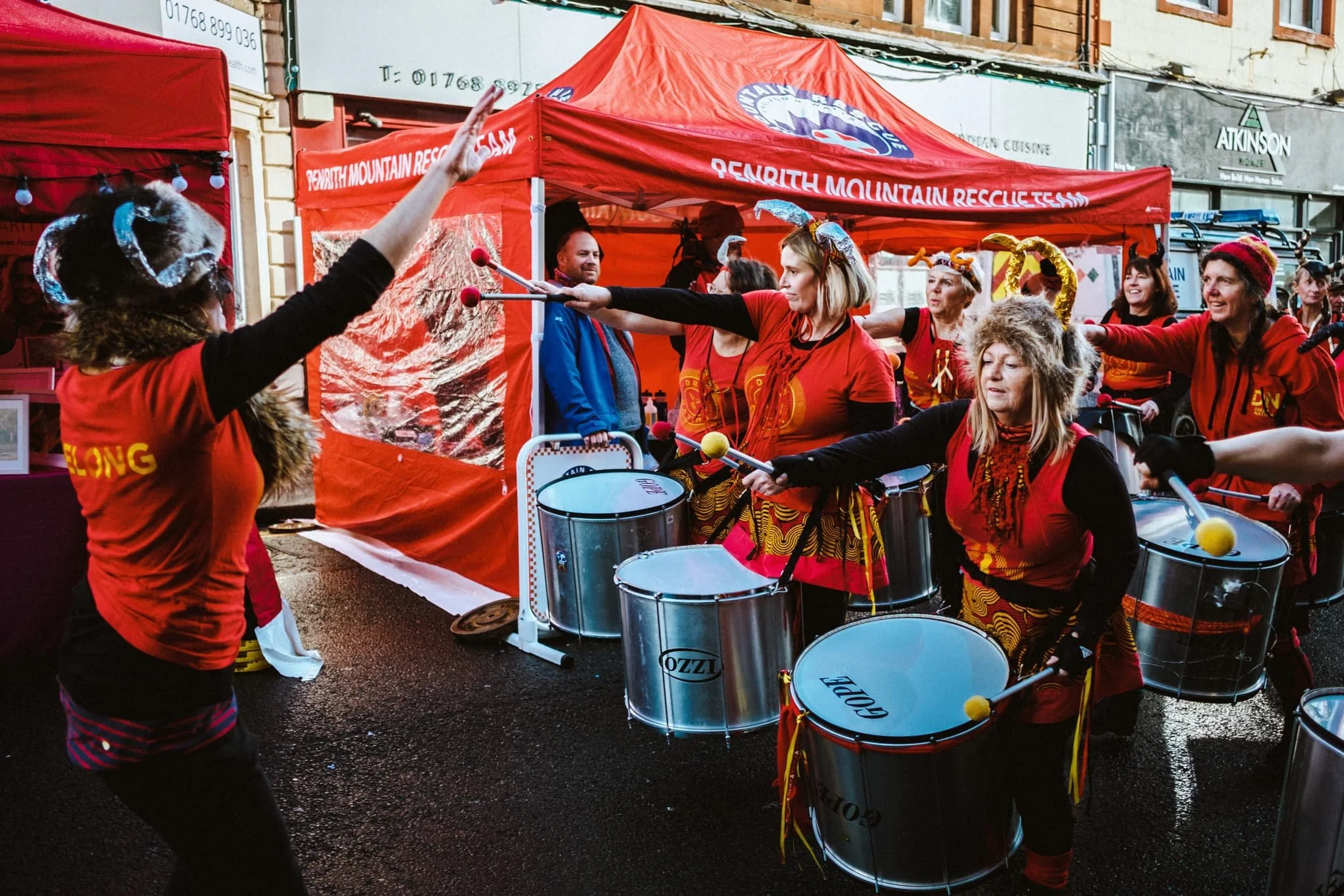
Back outside we followed the booming and crackling sounds of drums.
The Drum National samba band, in full swing.
The faces of joy and concentration. I miss drumming…
Loved the headwear and outfits too.
I mean, look at those horns.
The only person who didn’t seem to be having as much fun as everyone else…
A little donation to Penrith Mountain Rescue as the drumming band passes.
This lass was cool! I think she’s called Nula Hula. A “one woman” hula hooping show.
Taking off clothes whilst stilling hula hooping? No problem.
Applying makeup whilst hooping? Peasy.
A drumming family, finished with their event for the day.
The Ferris wheel proved popular. That’s a no from me, though.
The Jamaican Street Food stall beckoned us once again with those exquisite smells. So we broke for lunch.
Looking for a table to sit at, I came across this Viking family who were understandably attracting a lot of attention.
This goat curry was sublime, and a first for me in two ways: I’d never had Jamaican food before, and I’d never eaten goat before. Absolutely delicious; the goat was slow-cooked on the bone, too. It came with rice, pickled coleslaw, and “festival”—that is, Jamaican Festival bread.
After our tasty food we watched this guy do his incredible balancing tricks and acrobatics. Dude got the whole crowd pumping.
I mean, that balance. Those skills.
We meandered around the outskirts of the Winter Droving festival, ducking in and out of Penrith’s various yards. Two old friends were steadily making their way into town, happily chatting away.
Not only were all the various bands and troupes super talented, their outfits were amazing too.
Next to the Sainsbury’s supermarket, there was a display of classic cars that we unfortunately missed.
Lisabet fancied a nibble of something, so we stopped at Penrith’s famous butcher/deli the Chopping Block. A firm favourite of Lisabet’s is Pastéis de Nata, Portuguese egg tarts.
Back in the town centre, all the fairground rides were in regular use and full swing as the sun was beginning its trajectory below the horizon. I wanted to see if I could get some motion blur shots of the Galloping Horse carousel. Didn’t turn out too bad!
We decided, with the light getting low, that we would venture for a small hike up Penrith’s nearby hill, Beacon Pike, and see what views and light we could get. But first, we needed to navigate through the crowds.
Gorgeous autumnal light.
We found Fell Lane and walked up the road to the permitted footpath that takes you up Beacon Pike. Horse chestnuts everywhere!
Beacon Pike is covered in a dense woodland known as Beacon Plantation. The autumn colours were glorious.
See? Stunning.
Our final destination of the day: Beacon Tower.
Glorious warm sunset light and incredible views across the Eden valley towards the Lakeland fells.
It was great to be back out again.
Kirkby Lonsdale, Cumbria, Summer
Of all the times I’ve visited Kirkby Lonsdale, I’ve never thought to properly photograph it.
Of all the times I’ve visited Kirkby Lonsdale, I’ve never thought to properly photograph it.
So… welcome to Kirkby Lonsdale! This historic town, situated on the edge of Cumbria near the borders of both Lancashire and North Yorkshire, was where my lovely Lisabet grew up. Kirkby is a truly beautiful place, which has attracted a lot of money in recent decades. Quite the difference compared to its more humble origins.
Kirkby Lonsdale is one of the few Cumbrian towns mentioned in the Domesday Book of 1086 AD, where it was recorded as Cherchibi (“village with a church”). This would suggest the presence of a very old church, which is indeed the case. The earlier construction was rebuilt by the Normans in the 12th century, and parts of the church, now known as St. Mary’s, still survive from this era.
The town gained a market charter in 1227 AD and an outdoor market has been held on Thursdays ever since. This long-held tradition of trade and markets is evident in some of the street names in Kirkby Lonsdale, such as Horsemarket and Swinemarket.
After a particularly lazy start to our Sunday, we ventured around Lisabet’s home town and the surrounding countryside to get some miles under our belt and some photographs in our cameras. The day was another glorious summer fare.
All photos taken on my Fujifilm X-T2 using two of my prime lenses: a Samyang 35mm f/1.2 and a Laowa 9mm f/2.8. The images were 80% made in-camera using a customised Velvia film simulation, with minor edits afterwards in Lightroom and Affinity Photo.
This is Devil’s Bridge, with more people swimming in the Lune than I’ve ever seen before in Kirkby Lonsdale. The bridge was built around 1370 AD, probably by the monks of St. Mary’s Abbey in York. It once carried traffic over between Skipton and Kendal, but was closed to traffic in the 1930s as it was too narrow for modern vehicles.
So many people swimming in the Lune and enjoying the Cumbrian summer. Some more respectful of the environment than others.
This part of the Lune around Devil’s Bridge is very popular for outdoor swimming, owing to its easy access, deep pools, and clear water.
People of all ages, genders, and races were enjoying a paddle and a swim in the river. And why not.
The verges of the riverside were lush with flowers and vegetation.
We took the riverside trail alongside the Lune, heading towards the Radical Steps.
This point marks the end of the riverside trail. The Lune was very low, which afforded us with some excellent reflections to photograph.
Heading up the Radical Steps. They lead down from the churchyard of St. Mary’s church to the riverside. Built in 1820 for a Dr. Francis Pearson, who had apparently developed a reputation as a political radical, the steps were constructed to divert the footpath away from his garden.
The view that John Ruskins once described as “one of the loveliest views in England, therefore in the world” (lol, funny man). It is a nice view, I’ll grant him that. It became famous after J. M. W. Turner painted it.
If Ruskin’s View is looking northeast, then this is the view southeast from the same spot. I would argue that it’s more interesting, especially as you can often make out the flat top of Ingleborough (723 m/2,372 ft) in the distance.
The riverside trail towards Underley has some rather beautiful trees.
The last of this year’s blossom of rhododendron. Pretty but invasive, and has a tendency to take over a woodland.
Out of the woods and into the open countryside, heading towards Underley. A rather perfect tree helped make this composition easy. If you were to draw any tree, this would be that tree.
Lisabet and I spotted some seriously massive bracket fungi on some of the trees on the edge of the riverside trail.
This tree would be a little harder to draw from memory, but only because of how fantastical its shapes and twists are.
This is the Underley Business Centre, revamped after a £250,000 investment with the Underley Estate. But once it was the Underley Works and Home Farm, workshops for more than 100 tradesmen who were employed on the estate, from foresters to joiners.
A new footpath connects Underley Business Centre with Kirkby Lonsdale, helping pedestrians to keep out of the road. Happily, it also offers lovely views towards the Barbondale Fells.
Roughly halfway between the Underley Business Centre and Kirkby Lonsdale is this gorgeous little building, so out-of-character compared with the rest of Kirkby.
A little bit of internet investigation reveals that this is Underley Lodge, a former gatehouse to the Underley Estate, now private tenanted accommodation.
The old primary school, St. Mary’s. This was also where Lisabet spent her primary school education. In fact, during her last year at primary school there, she spent a good chunk of it helping staff move books from this building to the site of their new school.
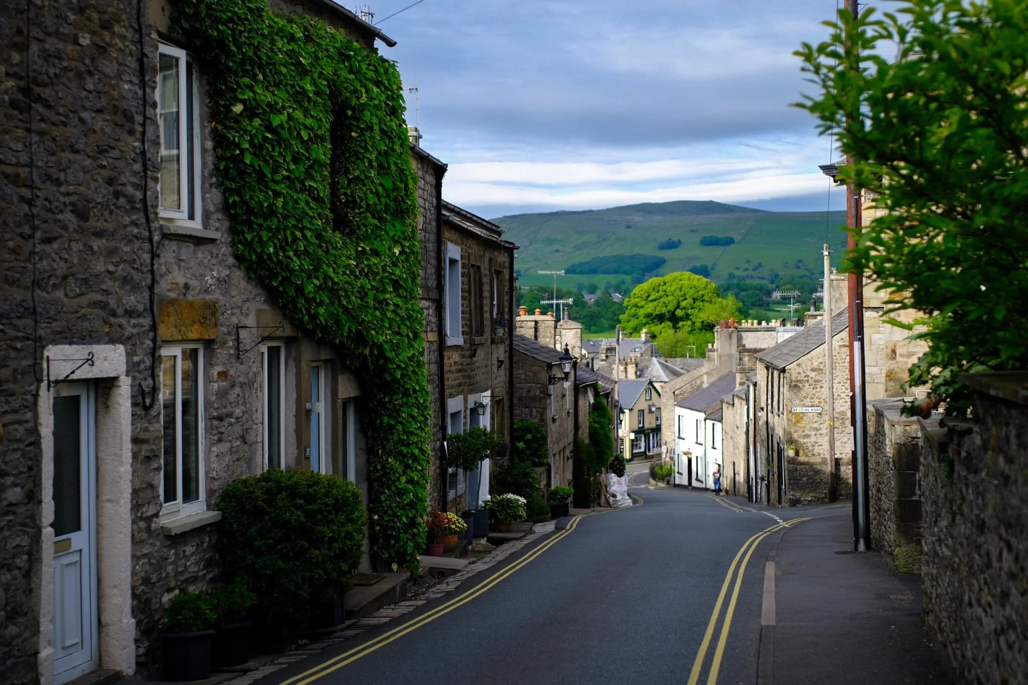
Another one of Kirkby’s famous scenes. This is the view down Mitchelgate towards Gragareth (628 m/2,060 ft).
Looking down Market Street from the bottom of Mitchelgate. Kirkby town centre is bonny.
St. Mary’s Church, probably the oldest building in Kirkby Lonsdale and ultimately what gave rise to the town’s name.
Parts of this church have survived since its Norman construction in the 12th century.
St. Mary’s churchyard is well-maintained and packed with flowers and trees alike.
The view down Mill Brow, which was once the industrial heart of Kirkby Lonsdale.
Halfway down Mill Brow is this incredible house. This is the Old Manor House, or 14 Mill Brow, most of which was built in 1700s (though apparently there are elements of the property that are older).
Looking south down Main Street, the heart of Kirkby Lonsdale town centre. Relatively few people about, but then I suspect that’s because most folk were swimming in the Lune.

Cockermouth, Cumbria, Summer
Let’s move away a little from the landscapes and nature.
Let’s move away a little from the landscapes and nature.
Lisabet and I recently had occasion to enjoy an outdoor swimming session with esteemed outdoor and wild swimming guide Suzanna Cruickshank. Not only was Suzanna a total delight, with the patience and compassion of a saint, but the weather couldn’t have been better with clear skies and 20+ degree sun. We were guided on a swim in Bassenthwaite Lake, which thankfully allows for a gentle drop into the water unlike most other lakes in the Lake District. The experience was exhilarating, fun, and freeing.
If you’re ever in Cumbria, and want a pair of safe hands to guide you through swimming in the lakes of the Lake District, I can wholeheartedly recommend Suzanna.
After our session, Lisabet and I decided to have summer’s day wander around Cockermouth, one of our favourite Cumbrian towns. We had a late birthday meal to catch up on, so booked a table at the beautiful Aspava for some of the finest Turkish cuisine around.
All in all, it were a top notch day, and of course I took some photos of it. I hope you enjoy these photo memories of mine as much as I enjoyed creating them.
All photos shot on my Fujifilm X-T2 using my Samyang 35mm f/1.2 lens. Images made 80% in-camera using a customised Classic Chrome film simulation, then minor edits applied after in Lightroom and Affinity Photo. The photo of me and Lisabet swimming in the lake is provided by kind courtesy of Suzanna Cruickshank.
Lisabet and I, swimming in Bassenthwaite Lake! Photo courtesy of Suzanna Cruickshank.
Making our way into Cockermouth town centre. “Shampoochies” is an excellent name for a dog grooming business.
Cockermouth is such a bonny town, especially in the summer.
The marble statue of Richard Southwell Bourke, sixth earl of Mayo, MP for Cockermouth between 1857-68. A famous resident of the town. He was assassinated in 1872 whilst visiting the Andaman Islands as Viceroy and Governor-General of India
A good way to start off a Turkish meal, with Turkish draft beer. Delightfully hoppy and refreshing.
Part way through our starter, comprising of hummus, cacık (a bit like Greek tzatziki), patlıcan ezme (a Turkish aubergine salad), Kısır (spiced bulgar wheat salad), Mücver (deep fried courgette fritter), and Patates Kavurma (boiled potatoes with onion, parsley and chilli).
A selection of grilled spiced meats with rice and salad. Nobody does meat better than the Turkish.
Baklava, one of the world’s most famous desserts. Layered filo pastry, filled with chopped nuts, and sweetened with honey.
Kopper’s Café and Bar, named as such as the building was the old Police Station.
The outdoor seating area of The Honest Lawyer, nicely decorated with hanging flowers alongside the River Cocker.
One of my favourite aspects of Cockermouth town centre is how colourful the buildings are.
See? Super pretty.
The Jennings Brewery, which started life in 1828 in the nearby village of Lorton.
The brewery is now owned by Marston’s PLC, itself part of Carlsberg UK.
All the ale and beer barrels.
We crossed the bridge and made our merry way through the Memorial Gardens, snapping idyllic scenes along the way.
Couple of young lads, deep in discussion.
Summer in Cumbria is one glorious vista after another.
A bit of old-school advertising on the side of this building. An indicator, too, as to the importance the brewery once had in Cockermouth.
A partially-masked man pauses in the street to reply to someone on his phone.
More traditional signage on the side of the Bridge Gallery building.
I love this side of Cockermouth, Market Place, with all the colourful buildings. More of this in Cumbria, please.

Stockdale, Settle, Yorkshire Dales, Spring
Summer has well and truly arrived.
Summer has well and truly arrived.
Following on from our little hike around Stenkrith Park and the Lune Gorge, Sunday greeted with us with clear blue skies and 20+ degree sunshine. That’ll do, nicely.
Endeavouring to stay away from our home county Cumbria and the Lake District, we ventured east towards the bonny Yorkshire Dales town of Settle. We fancied a repeat of 2020’s discovery in this area: Stockdale and the Attermire Scar. Hiking up High Hill Lane towards Scalebar Force from Settle, a common and popular walk, you’d have no idea of the limestone cliffs and crags in the valley to the north.
Branching off from High Hill Lane, a bridleway sign points out Attermire Scar. Following this route takes you into the Stockdale valley, where you can gawp at the incredible caves, cliffs, and limestone crags of Attermire Scar and Warrendale Knotts. Some of the best limestone karst scenery in all of the Yorkshire Dales.
And incredible weather to boot.
All photos shot on my Fujifilm X-T2 using my three prime lenses: a Samyang 35mm f/1.2, a Laowa 9mm f/2.8, and an adapted Pentax SMC 55mm f/2.0. Photos 80% made in-camera using a customised Classic Chrome film simulation, with minor edits later in Lightroom and Affinity Photo.
I don’t think this typographic mural has been on display in Settle all that long. Certainly wasn’t here when we last visited in 2020. Very nice work indeed, and lots of folk were taking pictures of it.
Swaledale ewe and lamb, basking in the day’s warmth up the fellside from High Hill Lane.
A scar in the fellside of High Hill with a remarkable likeness of some sort of prehistoric dinosaur footprint.
As we hike up Stockdale Lane, the views towards the limestone karst landscape start to open up and my excitement levels rise.
This collection of crags and scree is known as Warrendale Knotts, which tops out at 440 m/1,443 ft.
The Holstein Friesians seemed content in the warm fields of Stockdale.
Nearing the top of Stockdale Lane with Attermire Scar and Warrendale Knotts getting ever closer.
After nervously navigating past a field of young bullocks, and getting muddy boots in the process, a turn back for a shot of my lovely Lisabet. She cute.
The way to Attermire Scar and Warrendale Knotts. Already we could pick out fellow hikers below the scars as well as rock climbers high up the crags, testing their skills and might.
The east face of Warrendale Knotts, with some hikers ascending up the channel between this fell and Attermire Scar.
I shot this primarily for the zigzagging lines towards the crags of Attermire Scar.
Another Swaledale ewe and lamb, chilling beneath Warrendale Knotts.
The transitions between scree and grass create a repeating diagonal pattern that my eye enjoys. So I shot the photo.
The western aspect of Warrendale Knotts as it slopes back down towards Settle.
Well… you should know what I’m like with drystone walls by now. See that cave, middle-left? That’s where we rested for lunch.
The view back to Attermire Scar from our lunch spot, and probably my favourite shot from the day.
Again, a series of connecting lines around the photo that gives your eye something to wander around with.
Coming back down from the fells into Upper Settle, with its proper old-school Yorkshire vibe.
Settle is a popular meeting and rest destination for bikers.
Before heading home, we stopped off at the gardens of Settle Victoria Hall for light refreshment, and to give them our support.
A proper English summer fair vibe.

Pandemic Peregrinations: Kendal, Cumbria, Winter
Welp, despite Storm Christoph’s best attempts, snow and ice have returned.
Welp, despite Storm Christoph’s best attempts, snow and ice have returned.
The rain finally left Britain, with parts of North England and the Midlands getting flooded. It filled us with trepidation, having experienced our home being flooded during December 2015’s Storm Desmond. Thankfully, though the River Kent did get high, no serious flooding was reported in Cumbria this time.
Today we saw temperatures plunge once again, bringing overnight snow and frost into the county. As we’re still in a National Lockdown due to the global COVID-19 Pandemic, we retraced a familiar local favourite of ours: from the front to door to Old Sedbergh Road and up the fellside onto Paddy’s Lane. Then you follow the lane and exit back down to Kendal Jenkin’s Cragg Farm. You get a solid 10,000 steps doing it.
The going was dry and ice-free underfoot and the cloud base level was very low; it didn’t take us long stomping up Old Sedbergh Road to get into the cloud base and have our views completely washed out in fog. Never mind. Still got some lovely photos, I reckon.
All photos taken on my Fujifilm X-T2 using a Samyang 35mm f/1.2 lens. Developed using one of RNI’s Kodachrome film profiles.
The water level at the River Kent has dropped rather rapidly after Storm Christoph departed.
Kendal looks rather magical with a covering of frost.
We briefly came off Castle Street to explore the grounds of Castle Street Cemetery. It was like stepping back in time. The cemetery opened in 1843. The burial ground is now full and the chapel is disused.
Further up Sedbergh Road, near the allotments, our favourite local horses were having a proper feast on some sweet-smelling hay.
Up Old Sedbergh Road we go, as the road gets steeper each step.
The higher we climbed, the more the views disappeared into the winter fog.
A little spider web hammock.
This is the approach to the junction of Old Sedbergh Road and Paddy Lane, where Greyhound Farm sits. Really fogging up now.
With these kinds of conditions, you can snap some rather minimalist compositions.
Up on Paddy Lane. Trees and flora covered in corns of ice and frost.
High Jenkincrag Farm. Don’t know if it’s inhabited or not.
The route back to Kendal means you have to follow the Public Bridleway through Jenkin Crag Farm. And that means… cows!
All well fed and keeping warm, by the look of things.
The Castle Dairy. This is Kendal’s oldest inhabited building, built in the early 14th century and with some of those original features still in place. One might have assumptions based on the property’s name, but it seems it’s actually a corruption of Castle Dowery, a dower house for widows of the Barony.
The Bridge pub. Not sure what’s happening with this place; it’d been disused and on the market for years before news got out that it had been acquired in 2018. Still not open. Not sure it ever will be again.
Back up into Kendal town centre via Finkle Street. The name comes from the Old Norse word vinkle or vinkel, meaning “elbow” or “angle”. Accurate.
Heading past the New Shambles lane. Please do not feed the pigeons (people do, anyway).
New Shambles lane follows the route of an ancient path, Watt Lane; this went through property owned by the Trustees of the Market Place Chapel, back in the 18th century. It was redeveloped as the New Shambles in 1804 as 12 butchers’ shops. This lane became known as Stinking Lane as there weren’t any drains from the slaughter houses here (even though the owners paid “2/6”—two shillings and sixpence—a week to have the lane cleaned).