Gowbarrow, Lake District, Spring
Spring has changed very quickly in the UK.
Spring has changed very quickly in the UK.
A couple of weeks ago temperatures barely rose above 10ºC, often settling in at around 5–7ºC. Within the last week, temperatures have suddenly risen to 15ºC with clear skies and barely a breeze. Today, the weather nearly hit 20ºC.
Spring is very weird in the UK these days. That gradual transition from winter to spring doesn’t seem to happen anymore. Instead, after months of sub-5ºC conditions and plenty of rain, you’ll get a week in March or April where it feels a switch has been flicked and temperatures suddenly leap 10 degrees.
Weird.
Well, with a rare free day in current circumstances, Lisabet and I decided to get up early and head to Ullswater for a steep but rewarding hike up Gowbarrow Fell. The last time we visited this fell was back in April of 2021. The weather could not have been more different.
Thankfully, on this occasion, all of my batteries were fully charged and working. What a glorious morning’s hike we had.
All photos shot on my Fujifilm X-T2 using two of my prime lenses: a Fujinon 23mm f/2.0 and an adapted Pentax SMC 55mm f/2.0. Images made 80% in-camera using the Velvia film simulation, then finished off in Affinity Photo.
A dead tree provides a wonderful subject and contrast against the deep blue sky. A flock of Swaledales wearily judge us in the distance.
One of the many deep cascades along Aira Beck at High Cascades, before the river then plunges down the spectacular Aira Force.
These Swaledale yows moved a comfortable distance away from us for a good hard stare.
Beyond High Cascades the path turns east and climbs sharply up the fellside of Gowbarrow. Herdwick sheep were everywhere. I’ve missed those faces.
Unlike Swaledales, Herdwicks aren’t too fussed about being too near humans. I managed to snap this composition of some Herdwicks chilling in the glorious spring sunshine with the Ullswater fells in the distance.
The going was steep, but the views grew increasingly spectacular as we climbed up the fellside.
Aaaaaand summit! The summit of Gowbarrow Fell is known as Airy Crag, appropriately named, and reaches 481 m (1,578 ft) above sea level. The views here are all-encompassing, especially look southwest towards the Helvellyn fells.
I snapped on me 55mm lens for some tighter, zoomed in compositions. From the summit of Gowbarrow Fell and clear view towards Blencathra (868 m/2,848 ft) above Keswick can be appreciated.
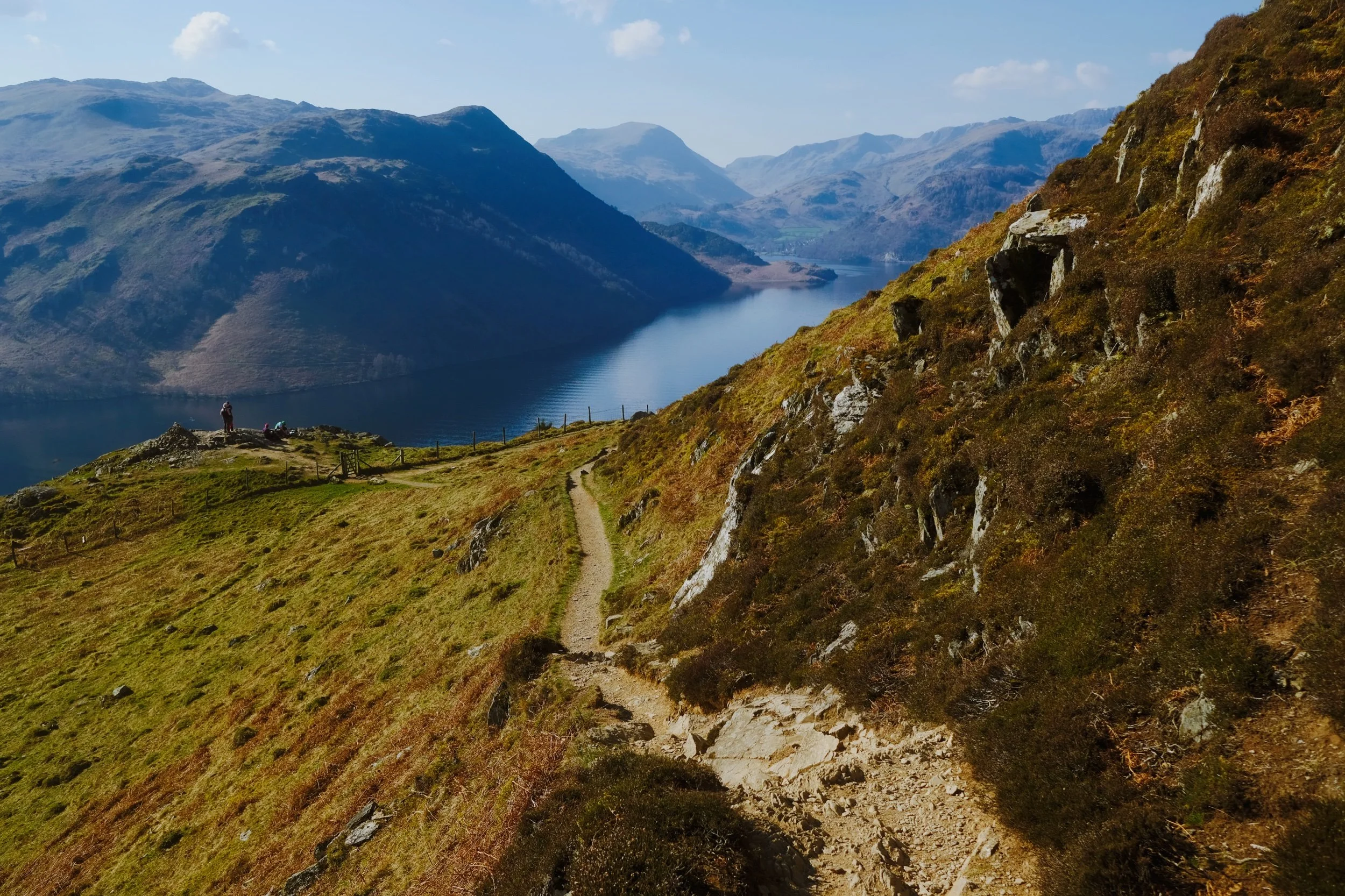
After the summit it was a simple task of following the narrow winding footpath around Gowbarrow’s northern and eastern shoulder. In places, the drop from the footpath is rather precipitous.
Lisabet pauses to check on my progress, so I snapped this composition. Truly glory awaits us around the corner…
Hundreds of metres below us the Ullswater Steamers begin the first of many travels across the lake.
And there it is. In my view, one of the grandest views in all of the Lake District. Ullswater and the Helvellyn fells.
Who can resist pausing for a rest and some photos, with a view like that?

Swaledale, Yorkshire Dales, Summer
Swaledale is one the northernmost and remote dales of the Yorkshire Dales.
Swaledale is one the northernmost and remote dales of the Yorkshire Dales.
The last time we visited the valley was back in May 2016, and we only really drove through the valley. In terms of actual hiking you’d have to go back to April 2014, the last time we hiked around Swaledale. Even then, we only did a small walk from the village of Keld to Crackpot Hall and back, just under 2 miles all in all.
Nowadays Lisabet and I are a lot fitter and slimmer so we enjoyed a much longer summer hike around the valley: from Keld, up the Pennine Way on the fellside of Kisdon (499 m/1,637 ft), down into Muker, through the famous Swaledale meadows, and back up the other side of Swaledale passing Swinner Gill and Crackpot Hall to get back to Keld.
About 7 miles in all, or 18,000 steps.
The weather treated us kindly, walking conditions were great, the light was clear, and the scenes were glorious. Swaledale definitely ranks as one of my favourite Yorkshire Dales valleys.
I enjoyed using the gate as an “arrow” pointing to the distant barn.
We took a small diversion from the Pennine Way to check out Upper Kisdon Force, which was still roaring despite the River Swale being relatively dry. Can’t imagine what these falls would be like in full spate.
After visiting Upper Kisdon Force we headed up the steep path to rejoin the Pennine Way, but not before stopping to behold this magnificent limestone needle in the gorge.
The Pennine Way, my Lisabet ahead.
Looking at Swinner Gill from the fellside of Kidson. Soft light caresses the fells.
Zooming in on the deep gash in the land cut by Swinner Gill.
Pulling back shows the extent of Swinner Gill and where it sits in Swaledale, as seen from the fellside of Kidson.
The summer sun gets filtered through the clouds, with the resulting soft light gradually rolling over the fellside of Arn Gill Scar and down into the valley bottom.
A Badger-faced lamb peeping above the ferns.
Upper Swaledale gradually broadens out here towards the village of Muker.
Looking back at Swinner Gill and Rogan’s Seat (672 m/2,205 ft) above it.
A fell runner navigates the Pennine Way towards Keld.
The way to Muker.
One thing you’ll note about Swaledale: there are lots of barns dotted about the valley, far more than any other dale in the Yorkshire Dales.
The Village Store at Muker, an impossibly pretty village in Swaledale.
Amongst other things, Swaledale is known for its explosion of wildflowers in the valley bottom meadows near Muker.
I can’t tell if we were perhaps two weeks too early or too late to see the peak of wildflowers blooming in Swaledale. Still gorgeous regardless.
Lisabet’s hair mesmerizes me.
Families and hikers take a rest beside the mouth of Swinner Gill
A highly excitable child clambers across the beck of Swinner Gill.
A lot of industry occurred in Swaledale during the 19th century, particularly lead mining. The fells around the valley are dotted with scars attesting to the industrial heritage of this area. It’s also apparent here at Swinner Gill, where you can find the ruins of a mining hut right near this waterfall. I wonder if the water flowing down this ravine was once used to power industry.
The ruins in question.
From Swinner Gill we made our way back to Keld. But I had to stop here for a shot of this magnificent view back towards Black Hill (509 m/1,669 ft) on the left and Kisdon on the right..
To get back to Keld the path takes you steeply down the fellside towards the river. Along the way you pass Catrake Force, pictured.
It’s a gorgeous setting. A true Yorkshire summer paradise.
The bottom of Catrake Force where it joins the River Swale into a deep gorge.
To my mind this is the quintessential Swaledale scene. Swaledale sheep grazing, grey barns as far as the eye can see, the curves of the valley, the fields neatly segmented by drystone walls, this scene has it all. Shot from Cloggerby Rigg near Thwaite.