Buxton, High Peak, Derbyshire
Buxton. Spas. Spring water.
Buxton. Spas. Spring water.
A certainty on our itinerary when holidaying in the Peak District was to explore the historical spa town of Buxton.
Though almost slap-bang in the middle of the Peak District, Buxton isn’t actually in the National Park. Look…

Buxton, in the Peak District area
Image courtesy of VisitBuxton.co.uk.
This means Buxton has excellent links to other parts of the National Park.
Buxton has been inhabited since the Stone Age, but the first major development of the area came courtesy of the Romans. They named the settlement Aquae Arnemetiae, that is, "Baths of the grove goddess".
Various peoples throughout history have treasured Buxton for its natural geothermic spring, which constantly gushes water out at a steady 28ºC. The town grew in the 18th century due to the Dukes of Devonshire, but it was really in the Victorian era where Buxton drew the crowds. Touring Victorians were attracted to the reputed healing powers of the natural spring.
We enjoyed a long and pleasant meander around the town, on what turned out to be a wonderfully clear autumnal day. Buxton really showed off what it had to offer.
All photos taken on my Sony α7ii using my Sony FE 28–70mm f3.5–5.6 OSS zoom and Rokinon 14mm f2.8 ED AS IF UMC prime lenses. RAWs developed and edited in Lightroom for iPad using Digistock’s Ektar 100 profile.
Buxton, High Peak, Derbyshire by Ian Cylkowski is licensed under CC BY-NC-SA 4.0![]()
![]()
![]()
![]()
We first wandered around Buxton Park before entering the town proper. Beautiful autumn colours were really starting to pop all around the park. Geese were plentiful, too, and clearly very accustomed to humans.
A fellow tourist takes in the view across one of the many ponds and lakes in the park. In actuality, these ponds are all part of the River Wye, which was heavily landscaped in the 19th century.
The park and Pavilion Gardens were opened in 1871, designed by Edward Milner, a well-known landscape architect. He also developed three parks in Preston, Lancashire, amongst many others.
Another lovely English scene, full of ducks, meticulously maintained landscaping, and Victorian architecture.
Buxton Opera House was designed by Frank Matcham in 1903. It’s reportedly the highest opera house in the country. Matcham also designed several London theatres, including the London Palladium, the London Coliseum, and the Hackney Empire.
Buxton saw a decline as a spa resort in the early 20th century. The Opera House re-opened in 1979 with the launch of the Buxton Festival, and the town saw rejuvenation as a base for exploring the Peak District.
Part of the Pavilion Gardens is this 19th century conservatory. Originally, the building was used as a small concert hall, complete with organ. In 1982 it was remodelled as a greenhouse conservatory, with tropical plants and a fish pond.
The Conservatory now houses many beautiful plants, several of which are extremely rare to find anywhere else in the UK.
A visit of Buxton is not complete without checking out St. Ann’s Well and the Pump Room. The room was built in 1894 to dispense the well's water from taps for drinking. Now restored and managed as a Tourist Information Centre, I shot this 10-shot panorama to really take in the Victorian architecture.
Buxton Town Hall, opened in 1889, was designed in the style of a French château. It now houses the offices of High Peak Borough Council.
Around the corner from the Opera House, we found this wonderfully preserved piece of living history: a Victorian chemists’. The shop assistant even showed us a ledger they’ve kept of patients and their prescriptions all the way back to the Victorian times.
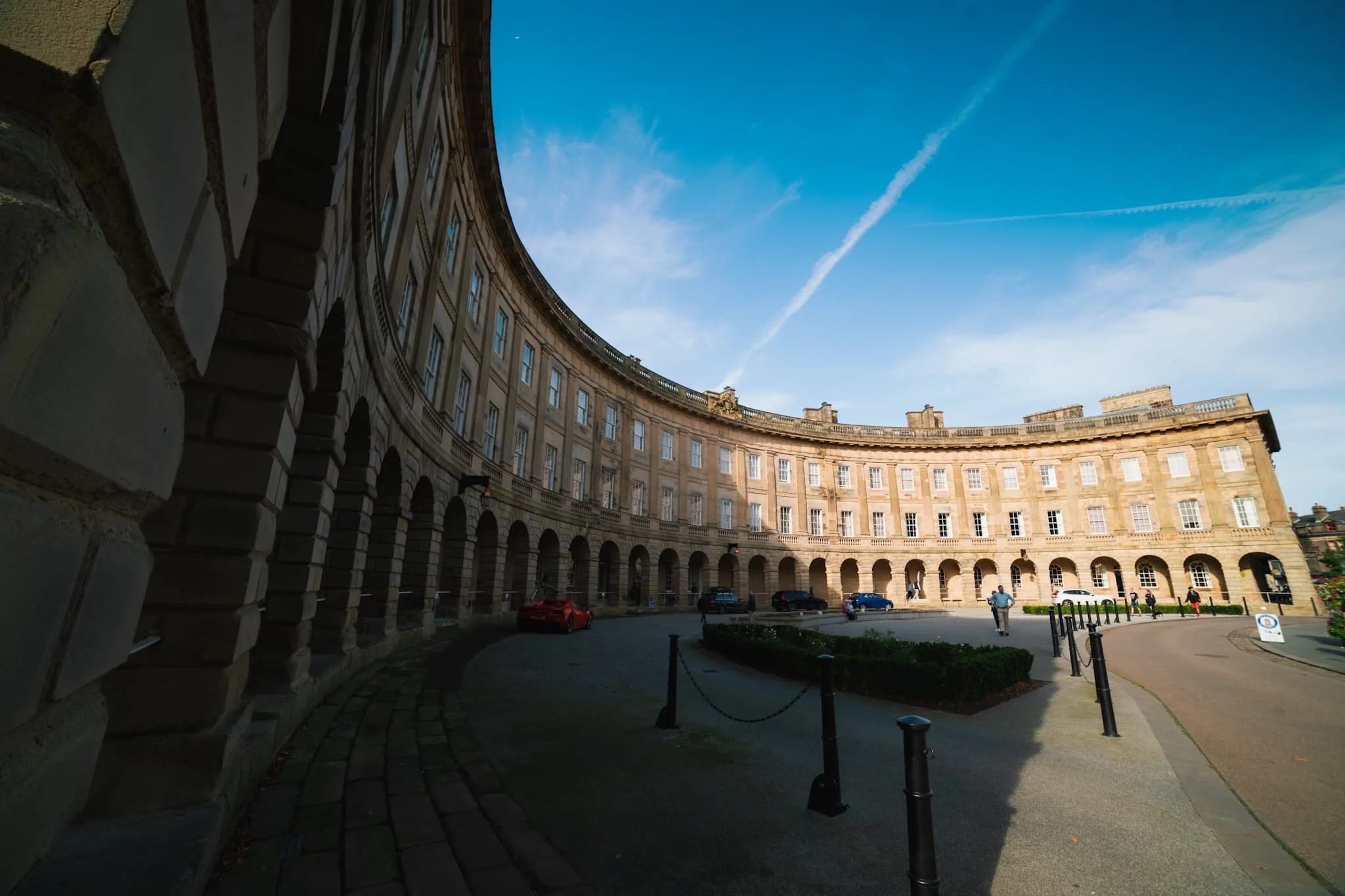
The crowning jewel of Buxton: the Crescent. It is often compared to the more famous Royal Crescent in Bath, but some argue that Buxton’s is “more richly decorated and altogether more complex”.
The Crescent was built in the late 18th century for the 5th Duke of Devonshire. His plan was to elevate Buxton into a popular Georgian spa town. It was built as a unified structure incorporating a hotel, five lodging houses, and a grand assembly room with a fine painted ceiling. By the mid-1980s the last part of the Crescent that was still functioning as a hotel closed due to the high cost of necessary repairs. Then, the whole building was closed when major structural problems were discovered in 1992.
What followed was a couple of decades of the building changing hands, fundraising for essential repairs and upgrades, and consulting on its future. Finally, in October 2020, Ensana reopened the hotel following 17 years of refurbishment.
Did you enjoy these photos?

Blelham Tarn, Lake District, Winter
Time for somewhere new (to us).
Time for somewhere new (to us).
In all my time of living in Cumbria and visiting the Lake District, I’ve never set foot near one of the Lake District’s most popular attractions: Wray Castle.
Wray Castle is perched on the high ground above Windermere’s western shore. Built in 1840, it’s not actually a castle but a private home. It was built for a retired Liverpool surgeon who commissioned it. Apparently his wife, upon completion, refused to live in it.
Nearby, one can enjoy a plethora of walks, all with their own charm and views to offer. On this occasion we elected for the Blelham Tarn walk, a valley tarn that drains off into Windermere.
The weather, for a brief period, threatened to brighten up but soon the clouds came down and signalled the end of the day’s hiking.
Definitely one to revisit in the spring or summer.
All photos taken on my Fujifilm X-T2 using a Vivitar “Series 1” 28–105mm f2.8–3.8 and my new Super Ozeck 80–205mm f4.5. RAWs converted in Capture One or iPad, developed using RNI Films, and finalised in Affinity Photo 2 for iPad.
Blelham Tarn, Lake District, Winter by Ian Cylkowski is licensed under CC BY-NC-SA 4.0![]()
![]()
![]()
![]()
Before setting off for the Lake District, Lisabet and I found—then purchased—a Super Ozeck 80–205mm f4.5 lens. As it was made for the Pentax K mount, and I have a Pentax K–Fuji X mount converter, it works flawlessly with my Fujifilm X-T2. Now I could zoom all the way into 205mm!
Stricklandgate and Windermere Road, shot from all the way up in Kendal town centre. Pretty damn chuffed with this purchase!
After arriving at Wray Castle, the views immediately opened up across Windermere.
This was about as good as the light got, but I’ll take it. Windermere with a slither of light scanning across the flanks of Wansfell Pike.
The splendour that is the Gothic Revival style of Wray Castle. Complete with inaccessible turrets and slit windows you could shoot fictitious arrows from.
A watch tower of sorts guards the entrance to the grounds of Wray Castle.
Before we could spot Blelham Tarn, Latterbarrow (245m/803ft) made itself immediately known to us. This is definitely one we’ll tackle in the near future.
My new Super Ozeck lens apparently has Macro functionality, so I decided to test it on some otherworldly lichen on a dead tree trunk.
On the higher ground south of Blelham Tarn, more panoramic scenes emerged with Wansfell Pike look tall and proud.
The memories of autumn cling on to the sides of a small beck.
Definitely a composition I need to return to when conditions improve.
The watch tower signals our return back to Wray Castle, 3-miles or so later.
Did you enjoy these photos?

Paddy’s Lane, Cumbria, Summer
2022 has got more twists and turns than a goat’s intestines.
2022 has got more twists and turns than a goat’s intestines.
This isn’t the place to rant. Suffice it to say, it’s been a super frustrating year. Thankfully, I have had a small nugget of personal positive news, which I’ll clutch tightly to my chest and use as a shield for whatever 2022 has next for me.
As it’s summer in Cumbria that means it’s sunny as well as rainy. Over the weekend I had some time to enjoy a local hike from Kendal up to Paddy’s Lane via Old Sedbergh Road. The clouds and conditions were pretty epic on the way up; unfortunately I got caught out on the way down and got pretty soaked.
Managed to keep the new lens dry, though. And thankfully, the Fujifilm X-T2 is weather sealed.
All photos taken on my Fujifilm X-T2 using a Vivitar “Series 1” 28–105 mm f/2.8–3.8 lens. Developed in Lightroom, finished off in Affinity Photo.
Now that the Queen’s Platinum Jubilee celebrations are over, Kendal Town Hall has re-erected the Ukrainian flag above the town.
These houses along Thorny Hill always put me in mind of Harrogate.
Underneath the railway line and onwards to Old Sedbergh Road.
With all the intermittent periods of rain + sun + rain + sun, I imagine this fella’s got his work cut out on his allotment.
Heading up Old Sedbergh Road, I spy three alpacas happily grazing in the fields.
Looking back at the route I took, the light still good. This wouldn’t last long. Look at those clouds above Kendal Fell…
As I climb the Lake District fells reveal themselves. It’s all looking a bit brooding and foreboding.
A final blast of sun before the storm clouds really close in.
The distant fells start to get hazy as the approaching rain saturates them.
Hoo boy, that’s the direction I’m heading in, too. Looks like I’m gunna get drenched…
Other people had timed it well and were already on their back down into the town.
I took the opportunity to nab some proper stormy images before the rain blew across the Kendal valley towards my position.
The dog walkers ahead quickly donned their hoodies as the gentle pitter-patter of rain started to fall.
As the rain got heavier I took shelter underneath a thick pair of trees and decided to wait things out. Whilst I did, I snagged this composition of the road onwards.
Eventually I made it back to town and the rain let up for long enough that I could snap a pic of this magnificent and ancient building.
Did you like these photos?
Grisedale, Lake District, Summer
It was time to show Dad the glory of Grisedale.
It was time to show Dad the glory of Grisedale.
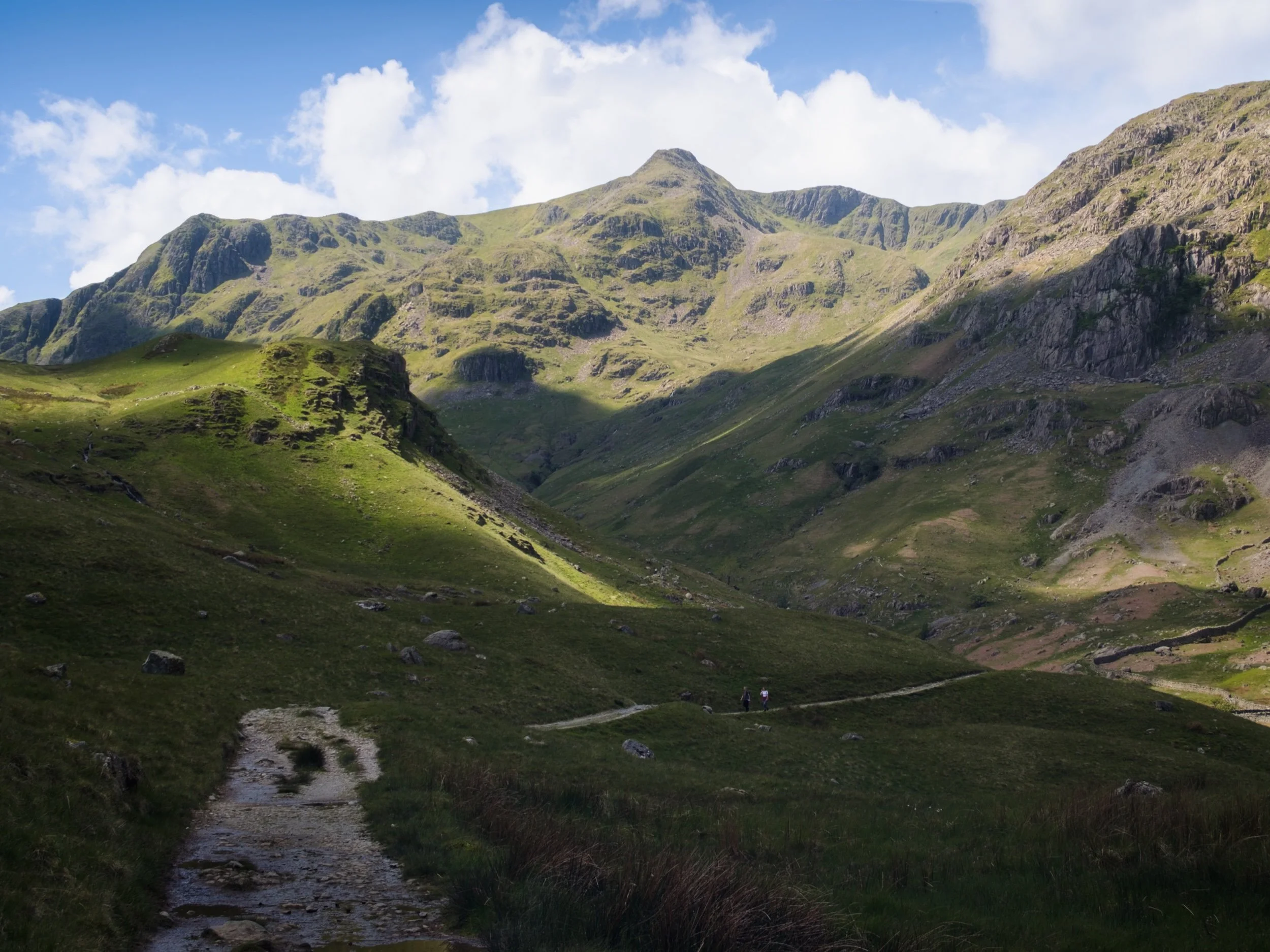
With the Queen’s Platinum Jubilee giving us two days holiday, Dad and I were able to spend some time together. We embarked on a hike up Grisedale, an offshoot of the main Patterdale valley near Ullswater. To my mind, Grisedale features one of the greatest valley sceneries in all of the Lake District.
I’ve attempted to show Dad Grisedale before, but the good ol’ Lake District rain has impeded us.
This time, we could not have asked for better conditions.
Please enjoy these glorious scenes. And, if you do like them, consider supporting me.
All photos taken on my Fujifilm X-T2 using my new Vivitar “Series 1” 28–105 mm f/2.8–3.8 lens. Developed in Lightroom, finished in Affinity Photo. Grisedale, Lake District, Summer © 2022 by Ian Cylkowski is licensed under CC BY-NC-SA 4.0.
Parking up at Patterdale’s King George V playing fields and pavilion, you are immediately greeted with the sheer face of Place Fell.
The lane leading to Grisedale is lined with rhododendron. I think this one may be Rhododendron fauriei.
The first inkling of what lies ahead. Black Crag, a sub-peak of St. Sunday Crag, soaring above us into the clear blue sky.
The road from Patterdale to Grisedale is quite the pull, but once you arrive at the valley… wow. One of the best valley backdrops in all of Lakeland.
There were a few hikers about, which is to be expected on a Bank Holiday. However, most of them were heading up the main trail to Helvellyn via Striding Edge. Not for us, thanks.
Testing out the capabilities of my Vivitar lens. This was shot at the full 105 mm zoom. A local farmer muck spreading across the valley bottom.
At Elmhow Farm, a composition catches my eye. A small barn fell into shadow, and I notice the similarity of its silhouette with the peak of Dollywaggon Pike above. A connecting shadow cast by the passing clouds completed this composition.
Beyond Elmhow, the valley starts to narrow as we approach the head. All along the way, Dollywaggon Pike watches over us.
I love watching clouds cast shapes and shadows on a fellside.
The cloud cover starts to thicken, casting deep shadows across the mountainous landscape. Glorious light conditions.
The trail narrows and winds as we approach the head of Grisedale. High above us are Falcon Crag and Tarn Crag, which drop down to Grisedale Tarn.
The path leads around the bottom of Post, on the left, a small crag that rise out of the valley floor. Above, Dollywaggon Pike is illuminated in between the racing clouds.
The small crag of Post, on the near left, enjoys a slither of summer light scanning along its surface. In the distant left are Falcon Crag and Tarn Crag, dead centre is Dollywaggon Pike, and to the right is Eagle Crag, a sub-peak of Nethermost Pike.
Immediately above us, on the southern side of the valley, is the sheer wall of St. Sunday Crag.
Dollywaggon Pike, punching the sky, cast in light and shadow. The joy of exploring the scenery at 105mm.
Another 105mm composition, zooming in on the crags of Eagle Crag as the light plays across them.
Looking back at our progress, down the length of Grisedale back towards Place Fell.
Crossing the boggy valley floor at Grisedale Beck, Dollywaggon Pike still demanding attention as its sunlit peak acts as a beacon.
The sheer wall of St. Sunday Crag, immediately above the Crossing Plantation.
Zooming on St. Sunday Crag and the shoulder of Post, criss-crossing each other in an interesting light-filled composition.
Place Fell’s bulk rises above the rolling valley bottom of Grisedale.
Our route back involved navigating the trail on the northern side of Grisedale. Here, erect ferns line the path, ready to bloom any day.
A person-sized glacial erratic, cleft in twain.
Another look back at Grisedale’s magnificent backdrop, with fellow hikers not far behind us.
A beautiful Herdwick ewe navigates the northern fellside amongst the fern.
The last of the year’s bluebells catching the light inside Broomhill Plantation.
My Dad after nabbing a shot of the frankly stunning scenery.
A Texel (?) yew enjoys a rest in the ferns.
Her lamb, following suit.
One last look back at Grisedale, now with more cloud cover making the sun beam shafts of light on the landscape. St. Sunday Crag to the left, Dollwaggon Pike and Nethermost Pike on the right.
Back on the valley floor, a Herdwick lamb stares at us quizzically.
Another lamb enjoys a mid-afternoon snooze in the summer sun.
Do you like these photos?

Scout Scar, Lake District, Spring
2022 has been fuckin’ wild so far.
2022 has been fuckin’ wild so far.
But finally, things are a bit happier. Family members that had been in hospital for separate issues are now home and recuperating.
It’s been stressful, and there have been somber conversations.
Let’s hope the 2nd half of 2022 improves.
We’ve got my Better Half’s sister staying with us for a while. She, too, is a photographer, and considerably more established and talented than me. Today, the sun rose and a glorious spring/summer’s day was upon us. We all, keenly, felt the need to be out in nature. What better way than to explore our own back garden as it were? Up to Scout Scar we go!
All photos taken on my Fujifilm X-T2 using my three prime lenses and a new lens (more on that further in the post): a Fujinon 23mm f/2.0, a Laowa 9mm f/2.8, and an adapted Pentax SMC 55mm f/2.0. Developed in Lightroom, finished in Affinity Photo.
Heading up Helsington Laithes, a scene of serene summery simplicity.
How about this for r/RuralPorn?
Finally, up the back of Scout Scar and over its spine to enjoy the extensive views across the Lyth Valley towards the Lake District fells.
A lone tree growing out of the limestone acts as a nice “signpost”, pointing at the Lake District fells.
I never get tired of the sheer drop from the cliffs of Scout Scar.
Looking back south. The atmosphere was so clear that we could easily make out the Kent Estuary, which leads out to Morecambe Bay, with Arnside Knott above it.
The Kentmere and Longsleddale fells using the limestone cliffs as a leading towards them.
I think this is one of the bigger vertical drops along Scout Scar, highlighted by the tiny people waltzing along the top.

I think these might Helianthemum nummularium, or Common rock-rose. They apparently prefer dry, base-rich soil, and as limestone—which is what Scout Scar is made of— contains a lot of Calcium Carbonate (CaCO3), an alkaline material, this would make sense.
I can tell I’ve not been up Scout Scar much during the late spring/summer, because I had no idea there were so many beautiful flowers along the cliff tops! My ultra-wide angle lens had a lot of fun.
A 3-shot vertorama featuring the nick and drop of Hodgson’s Leap with the Lyth Valley and the Lakeland fells beyond.
It’s so good for the brain to see everything looking so green again.
Beyond the nick of Hodgson’s Leap, Lisabet and her sister were motoring on ahead, heading towards the Mushroom. In the distance, the Kentmere fells, clear as a bell.
View after view after view. It’s hard to pick just one.
The Lake District fells, with the Langdale Pikes in the centre, shot from the summit of Scout Scar, which is crowned by the Mushroom shelter.
Back down the back of Scout Scar, with the Howgills looking lovely.
After we made it back to town and refuelled with coffee and lunch, we browsed some of the charity shops. In the window of Oxfam, I spotted a Vivitar “Series 1” 28–105mm f/2.8–f/3.8 zoom “macro” lens, made for the Pentax K/Ricoh mount. I already have a Pentax SMC 55mm f/2.0 with the relevant adapter to mount on my Fujifilm X-T2, so this zoom lens would work too. It included the box case, plus manual and beautifully made leather pouch case. And all for £30! So I nabbed it! And the above is a shot using my new lens, zoomed in all the way to 105mm. Bargain!
Did you like these photos?

Brigsteer Park, Lake District, Spring
I wanted to see a lot of bluebells one last time for this year.
I wanted to see a lot of bluebells one last time for this year.
A work colleague tipped me off about Brigsteer Park, a woodland south of its village namesake, Brigsteer. The village sits underneath Scout Scar, and there’s a surprising amount of woodland underneath this fell.
So, Lisabet and I parked up at Helsington St. John’s Church and plotted a route down the fell slope, through a Bee Reserve and into Brigsteer Park for a ruddy good exploration.
All photos taken on my Fujifilm X-T2 using two of my prime lenses: a Fujinon 23mm f/2.0 and an adapted Pentax SMC 55mm f/2.0. Images developed using RNI Films’ Kodachrome film profiles.
The views from the car park Helsington St. John’s church are sublime. All the way across the Lyth Valley to the Lake District fells.
The southern shoulder of Scout Scar and the small road that allows access to Helsington St. John’s Church.
As we navigate the footpaths down the fell slope, Whitbarrow commands your attention directly across the Lyth Valley.
Couldn’t resist a shot of this gorgeous old house, covered in ivy.
A delightful little cottage on Park End Lane just before you enter Brigsteer Park.
Whoever lives at the cottage is a keen gardener. We had to look up what these weird and wonderful plants were. Turns out they’re probably Chilean Rhubarb, Gunnera tinctoria. Also, not actually related rhubarb though you can apparently consume Chilean Rhubarb as you would normal rhubarb.
Looking back at this impossibly idyllic scene before we head into the woods.
It turns out that Brigsteer Park is a proper woodland, thick with growth and full of old trees.
An old tree with its own “cane”.
Look at this old yew tree with its “ligaments” and textures. Isn’t it magnificent?
Another old yew, found further into the woodland.
As we neared the exit, I turned back to snap this scene. Unfortunately, I didn’t see any sign of carpets of woodland here at Brigsteer Park. Perhaps we were in the wrong bit?
Whitbarrow Scar once again commanding our attention from across the Lyth Valley.
After carefully navigating through some young cows and bullocks, we returned to Park End Lane. The gardener’s cottage here, cosily nestled in the woods of Brigsteer.
Everywhere is exploding in colour and wildflowers.
Brigsteer Causeway, which cross the wetter and more swamp-like part of the Lyth Valley.
Brigsteer is such a bonny village.
I mean, come on.
Not a bad place to do the rounds.
As we started climbing the road up back towards St. John’s Church, the views opened to us again. Here you can see right across the Lyth Valley and even the Kent Estuary towards Arnside Knott.
Not a bad way to spend the morning.
Did you like these photos?
Then support me.