
Under Loughrigg, Lake District, Winter
A brief respite amongst all the rain.
A brief respite amongst all the rain.
Despite the weather, this week has been as busy as ever. A large part of that is simply that it’s half-term for schools. Still, we figured people would be starting to head back home, so the Lake District wouldn’t be as busy.
Nope.
Our planned circuit of Grasmere was foiled due to every car park being full. Every. One.
So, change of plan. We managed to park further towards Ambleside, right next to the cricket ground, and instead do a small circuit around the Under Loughrigg area in between Ambleside and Rydal.
Still proper bonny. And, happily, signs of spring are starting to appear.
All photos taken on my Sony α7ii using my Pentax SMC 28mm F3.5 and Pentax SMC 55mm f2.0 prime lenses, plus Vivitar “Series 1” 70–210mm f2.8–4.0 zoom lens. RAWs developed in Lightroom, edited and finalised in Photoshop.
Under Loughrigg, Lake District, Winter by Ian Cylkowski is licensed under CC BY-NC-SA 4.0![]()
![]()
![]()
![]()
On the A591 between Ambleside and Rydal, one can enjoy formidable views towards Nab Scar (455 m/1,493 ft).
The flat pasture land in between Loughrigg Fell and the A591 allows for extensive views across to the surrounding fells. There were also plenty of signs of storm damage, with fallen trees and split trunks everywhere. In this case, it allowed for a nice composition towards a highlighted Low Pike (508 m/1,667 ft).
I cropped in tightly for this composition at 210mm to grab these Swaledale ewes milling around a beautiful crag, and subtle hints of the wall of Nab Scar in the background.
A surviving Scots Pine makes for a dramatic composition with the Kirkstone fells in dark shadow behind.
One of the Lake District’s well-known views, often causing sudden brakes by drivers on the A591. Looking towards Rydal, with the Kirkstone fells catching a sweeping lightbeam.
Did you like these photos?

Grasmere, Lake District, Winter
The winter lurgy has struck.
The winter lurgy has struck.
Following a lovely hike around Ambleside, Lisabet came down with a rather nasty cold and I followed suit soon after.
We’re both at the tail end of this bug now, but with depleted energy levels as can be expected. A crisp, clear, and super cold Sunday greeted us, so we set off towards the impossibly bonny village of Grasmere for a wee waltz around the area.
All photos shot on my Sony α7ii using my Pentax SMC 28mm F3.5 and Pentax SMC 55mm f2.0 prime lenses. RAWs developed in Lightroom and edited in Photoshop.
Grasmere, Lake District, Winter by Ian Cylkowski is licensed under CC BY-NC-SA 4.0![]()
![]()
![]()
![]()
The trail in the direction of Allan Bank enjoys wonderful views towards Helm Crag and Seat Sandal. Here, the latter of the two fells is stroked by golden afternoon light across its flanks.
Across the vale, the craggier yet smaller Helm Crag receives similar treatment from the emerging winter sun.
Heading down the hill towards Goody Bridge, the snowcapped Great Rigg on the right is illuminated. Love the rusty colours some of the Lake District and Scottish fells turn in the autumn and winter.
Expansive views from the Allan Bank trail lead to Seat Sandal being bathed in afternoon winter sun.
A timeless route back to the village centre. There’s no need to hurry.
Did you enjoy these photos?

Ambleside, Lake District, Winter
Temperatures have plunged.
Temperatures have plunged.
The nigh persistent rain of November and December has given way to a sub-zero climate and clearer conditions. Much better.
With a bright Saturday forecast, Lisabet and I ventured into the heart of the Lake District and major tourist hotspot, Ambleside. We wanted to do two walks: one, a small circular of Stock Ghyll Force, the other bigger hike up to High Sweden Bridge.
Despite being in the middle of a blisteringly cold winter in the Lake District, Ambleside was as busy as ever. This town never gets any rest.
All photos taken on my Sony α7ii using my SMC Pentax-M 28mm F3.5 and SMC Pentax-M 55mm f2.0 prime lenses, plus my Vivitar “Series 1” 70–210mm f2.8–4.0 zoom. RAWs developed in Lightroom, edited in Photoshop.
Ambleside, Lake District, Winter by Ian Cylkowski is licensed under CC BY-NC-SA 4.0![]()
![]()
![]()
![]()
A misty shot from the top of Stock Ghyll Force. Made by stacking five landscape 28mm shots, top to bottom, for a wider field of view.
The classic view of Stock Ghyll Force, currently in its more barren winter finery.
After stopping for delicious hot brews at Force Cafe, we followed the trail back down to the town. By the side of the road, this still life-esque scene revealed itself to me, and so quickly I quickly nabbed a composition.
From the town centre, it’s easy enough to find the route to the High Sweden Bridge trail. Given the direction of the low sun, we opted instead to take the trail anti-clockwise, which we’ve never done before, to get more side light.
The old packhorse bridge itself, with my Lisabet providing a nice colour contrast as she strolls across it. As I’ve mentioned on this site elsewhere, the name “High Sweden Bridge” might seem unusual, given this is located in the Lake District, England. The “sweden” aspect originally comes from the Old Norse sviðin (pronounced “swee-thin”), the past participle of svíða, meaning “to burn” or “to singe”. In this context, it refers to the clearing of land by burning.
Looking up Scandale, admiring the light beams scanning across the face of High Pike (656 m/2,152 ft).
Heading back down the higher eastern side of the Scandale valley, I equipped my 70–210mm lens for some tight and distant compositions. Fully zoomed in, I was able to pick out the mist clearing from the summits of the Langdale Pikes, on the right, and Bowfell on the left.
My 70–210mm also has a macro mode, which I used to try and capture these beautiful and tiny Cladonia pyxidata lichen.
Lake District sheep get all the best views.
Did you enjoy these photos?

Grisedale, Lake District, Winter
Happy New Year, everyone! Here’s to a peaceful and gentler 2024.
Happy New Year, everyone! Here’s to a more peaceful and gentle 2024.
Though I’ve enjoyed time off work between Christmas and New Year, it’s not exactly been pleasant. Storm Gerrit washed across the UK, rendering most days miserably wet. There were even tornado warnings, largely unheard of in the UK.
On New Year’s Eve we learned that New Year’s Day promised much nicer conditions, and so we endeavoured to rise early and head into the Lake District for a solid yomp on the first day of 2024.
Conditions were certainly nicer, though you can never predict weather in the Lake District 100%. Hiking along the valley bottom of Grisedale towards the valley’s head, we were washed with wave after wave of fine drizzle. Thankfully, it never rained that hard, and in between the downpours we still managed to nab some glorious photos.
All photos taken on my Sony α7ii using my Pentax SMC 28mm F3.5 and Pentax SMC 55mm f2.0 prime lenses. RAWs developed in Lightroom using RNI Films’ Kodachrome film profiles, finalised in Photoshop.
Grisedale, Lake District, Winter by Ian Cylkowski is licensed under CC BY-NC-SA 4.0![]()
![]()
![]()
![]()
A sign of things to come. St. Sunday Crag (841 m/2,759 ft), rising above a sodden landscape with stormy clouds above.

Much of the first half of hiking into the valley comprised of dodging waves of drizzle. When one cleared up for long enough, I snuck this shot of Eagle Crag and Dollywaggon Pike (858 m/2,815 ft) battling with the low clouds.
Arriving closer to the turning point, we contemplated the condition of the trail on the other side of the valley. The hike in, on the south of the valley, is thankfully paved but had still been rendered in parts as a beck due to all the rain. I knew that the northern path back down the valley wasn’t in as good nick. So, from here, we turned back the same way we came in.
Thankfully, this was also when conditions started to clear up and the Helvellyn range of fells began to reveal themselves.
Eagle Crag with Nethermostcove Beck roaring down the fellside. A project was started in 2021 to return the valley’s main river, Grisedale Beck, back to its original “wiggly” form. To quote the Friends of the Ullswater Way: “As with many rivers in the UK, Grisedale Beck has historically been straightened and reinforced so that fields can be drained to improve grazing. This work was undertaken over 200 years ago and since then we have learned a lot about how straightened and reinforced rivers can negatively affect wildlife and increase flood risk. It should be noted that, despite the historic changes made to the river at the project site, this is still not particularly good grazing land, being very rough pasture and quite boggy in areas.”
Heading back down the valley, we kept turning back at the beautiful view at the head of Grisedale. Primarily to check on any incoming rain washing over the fells, but also to gawp at them. I enjoyed this composition as the trail seemingly leads across the image towards Nethermostcove Beck on the right. Pure mood.
One of the few pines left in the valley points a vibrant branch towards the beautifully cracked glacial erratic.
As the cloud cover finally starts to lift, Falcon Crag and Tarn Crag emerge from behind Dollywaggon Pike.
Light finally breaks through the clouds as we retreat further down the valley.
The beck streaming down from Blind Cove provides a nice leading line towards the vertical face of St. Sunday Crag.

The fells become obscured again. Another wave of rain heads towards us.
As another squall washes over us, I look across to the northern side of Grisedale and spot these bright becks cascading down the fellside. I very quickly nab a photo.
Soon, we near the foot of the valley and the rains were finally done for the afternoon. Look at that mountain backdrop.
Heading back towards the car, the hulking mound of Place Fell catches the warm winter light across its crags.
We elected for the scenic route back to Kendal, heading north out of Patterdale, through Matterdale, and onto the A65. That way we could turn off to head down St. John’s in the Vale and join the A591 back to Kendal. I kept my camera out, with the 55m attached to it, and grabbed this epic scene of Blencathra from the passenger’s side.
Down St. John’s in the Vale, I kept snapping happily, praying that at least one of the shots rendered sharp. Here, the deep cleft of Beckthorns Gill cuts into various crags of Clough Head.
Further south on the A591, near Thirlmere, Fisherplace Gill cuts a deep fissure within the crags of the Helvellyn massif. The farmhouses below look miniscule in comparison.
The distinctive shape of Browncove Crags, a subsidiary top of Helvellyn, with another deep gill caused by Helvellyn Gill.
Did you enjoy these photos?
Colwith Force, Lake District, Autumn
The last of the summer holidays.
The last of the summer holidays.
After a lovely Friday evening in Dentdale, and a glorious Saturday in Kingsdale, we returned to the Lake District on Sunday for a hike to Colwith Force and back.
The weekend saw the advent of a heatwave settling over the British Isles. To counter, we head to Skelwith Bridge early in the morning for cooler conditions and before the majority of summer holidayers were about.
We were rewarded with beautifully moody, misty conditions to start, then as the temperatures rose the mist burned off, swirling around the fell tops and creating dramatic scenery. Just perfection.
All photos taken on my Sony α7ii using my Sony FE 28–70mm f3.5–5.6 OSS zoom and Rokinon 14mm f2.8 ED AS IF UMC ultra-wide prime lenses. RAWs developed in Lightroom using RNI Films’ Kodachrome film profiles, finalised in Photoshop.
Colwith Force, Lake District, Autumn by Ian Cylkowski is licensed under CC BY-NC-SA 4.0![]()
![]()
![]()
![]()
Typically, we start the walk to Colwith Force from Skelwith Bridge. From here we cross the River Brathay and head west. But before crossing the river, we can never resist getting up close and personal with the beautiful Skelwith Force.
Looking upstream from Skelwith Force. You can just about make out the bridge that takes you across the river.
Up and out of the woods around Skelwith Force, we head west where the views started to open up. Well, to a degree. Early morning fog clung to the fell tops, making for moody images.
Looking back down the route we came up. You can just about make out the knuckly profile of Loughrigg but nothing beyond.
After navigating a series of narrow footpaths punctuated with tight kissing gates and stiles, the trail starts to head back down Little Langdale. But before we do, this magnificent composition demands your attention: Wetherlam (763 m/2,502 ft) fighting the swirling mist as the morning sun burns it all off.
Down at the valley bottom we entered Tongue Intake Plantation and picked our way up through the woods to find our main goal for the day: Colwith Force, a double spout waterfall. Evidence of the approach of autumn is all around us.
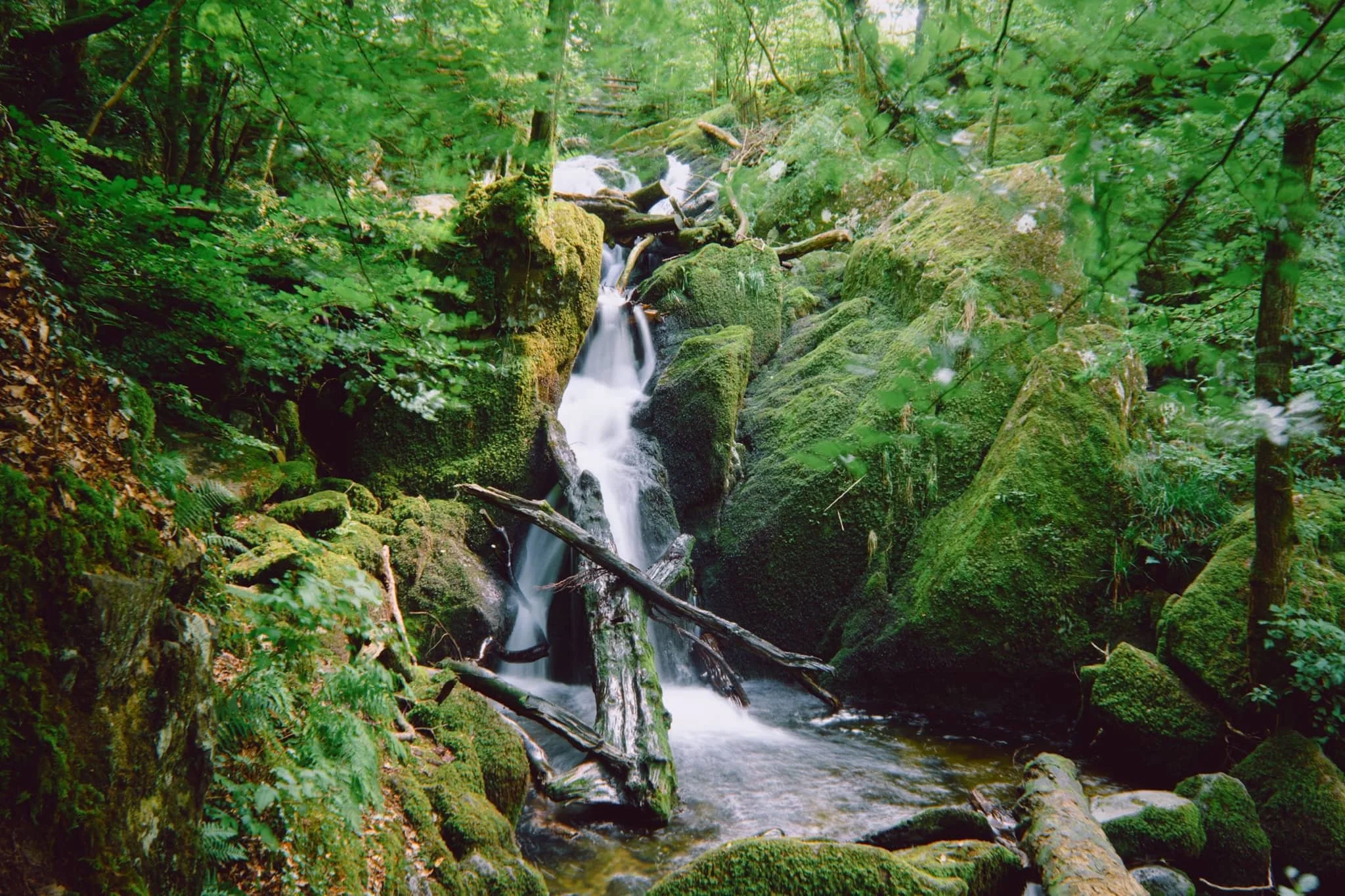
Some people simply turn around and head back, but we’re fans of following the trail as it ascends up and above the waterfall. From above it, interesting compositions can be found of all the falls before the main double spout.
Though a little dry this time, there’s a lovely series of falls above Colwith Force that deserve attention.
Beyond the upper falls we followed the circular trail back out of the plantation and sought the Little Langdale road back towards Skelwith Bridge. Emerging from the woods, the fells were now clear of the morning mist, revealing their autumnal coats.
Just goes to show the massive difference a change of light conditions can do to the mood and feel of a photograph. Loughrigg and the Grasmere fells beyond, now clearly visible.
Herdwick yows (ewes) and their lambs peacefully graze in the now gorgeous autumnal morning sun. A timeless scene.
Nearing Skelwith Bridge, we could finally see the Langdale Pikes after being consumed by the fog all morning.
Did you enjoy these photos?
Stockghyll, Lake District, Summer
Lots of rain means one thing: waterfalls.
Loads of rain means one thing: waterfalls.
Though certainly not as numerous or epic as in the Yorkshire Dales, the Lake District is still home to some lovely waterfalls.
Certainly one of the more accessible, yet grand, waterfalls is Stockghyll Force in Ambleside. We last hiked around here in June 2020, just as the UK’s COVID-19 lockdown was starting to ease off. Ambleside, usually one of the busiest honeypots in all the Lake District, was eerily quiet on that visit.
Things were very much back to normal this time. Lots of people about, sipping pints in pubs, chatting over coffee and cake with friends, and hiking in and around the town.
And all the rain we’ve had in July has meant that Stockghyll Force should be in full flow. Boy did she look good.
All photos taken on my Sony α7ii using my Sony FE 28–70mm f3.5–5.6 OSS zoom lens. RAW files were corrected in Lightroom, developed using RNI Films’ Kodachrome film profiles, and finalised again in Lightroom.
Stockghyll Force, Lake District, Summer by Ian Cylkowski is licensed under CC BY-NC-SA 4.0![]()
![]()
![]()
![]()
From the car park opposite the Log House, we elected for the back roads towards the waterfall, rather than trekking alongside the main road. It gave us lovely, almost timeless, scenes like this.
Soon enough we exited the town centre, hiked up the road alongside the beck, and head into the woodland surrounding the waterfall. A lovely little weir, bathed in sunlight, made for a nice composition.
Further into the woods, a small beck flows underneath this delightful little bridge.
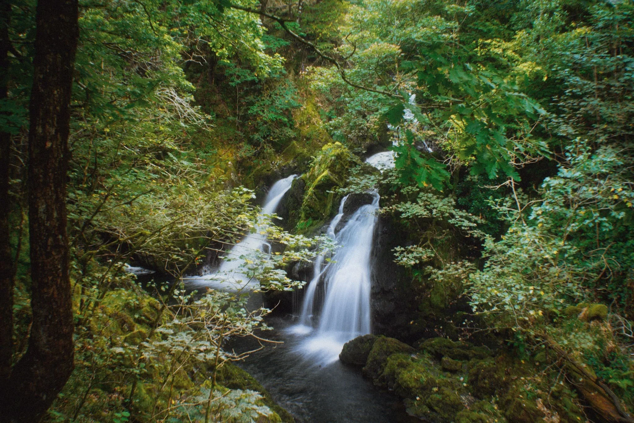
At the main waterfall itself, I perched myself and the tripod gingerly on a crag above the main drop, seeking a composition looking all the way down the falls to the gorge below.
The upper part of Stockghyll Force, surrounded by jagged, mossy crags and lush verdant vegetation everywhere.
After leaving one side of the trail, we took a lunch break at a new cafe that’s recently opened not 30 m away from the waterfall. Force Cafe. Delicious food and drink, and absolutely stunning views from their open terrace.
Heading back down the other side of the trail, the classic view of Stockghyll Force emerges and I cannot resist.
However, just a little further down the trail, I think the best view of Stockghyll Force can be obtained.