
Under Loughrigg, Lake District, Winter
A brief respite amongst all the rain.
A brief respite amongst all the rain.
Despite the weather, this week has been as busy as ever. A large part of that is simply that it’s half-term for schools. Still, we figured people would be starting to head back home, so the Lake District wouldn’t be as busy.
Nope.
Our planned circuit of Grasmere was foiled due to every car park being full. Every. One.
So, change of plan. We managed to park further towards Ambleside, right next to the cricket ground, and instead do a small circuit around the Under Loughrigg area in between Ambleside and Rydal.
Still proper bonny. And, happily, signs of spring are starting to appear.
All photos taken on my Sony α7ii using my Pentax SMC 28mm F3.5 and Pentax SMC 55mm f2.0 prime lenses, plus Vivitar “Series 1” 70–210mm f2.8–4.0 zoom lens. RAWs developed in Lightroom, edited and finalised in Photoshop.
Under Loughrigg, Lake District, Winter by Ian Cylkowski is licensed under CC BY-NC-SA 4.0![]()
![]()
![]()
![]()
On the A591 between Ambleside and Rydal, one can enjoy formidable views towards Nab Scar (455 m/1,493 ft).
The flat pasture land in between Loughrigg Fell and the A591 allows for extensive views across to the surrounding fells. There were also plenty of signs of storm damage, with fallen trees and split trunks everywhere. In this case, it allowed for a nice composition towards a highlighted Low Pike (508 m/1,667 ft).
I cropped in tightly for this composition at 210mm to grab these Swaledale ewes milling around a beautiful crag, and subtle hints of the wall of Nab Scar in the background.
A surviving Scots Pine makes for a dramatic composition with the Kirkstone fells in dark shadow behind.
One of the Lake District’s well-known views, often causing sudden brakes by drivers on the A591. Looking towards Rydal, with the Kirkstone fells catching a sweeping lightbeam.
Did you like these photos?
Loughrigg Fell, Lake District, Spring
Step 1 of the UK Government’s Spring 2021 COVID-19 plan has been completed.
Step 1 of the UK Government’s Spring 2021 COVID-19 plan has been completed.
From Monday 29th, more people can now meet outside, outdoor recreation activities are permitted again, and the “Stay at home” ruling has relaxed to “Stay local”.
I’ve taken some time off work before and after the Easter weekend in order to recuperate. I’ve been feeling burned out for quite a while now. So what did we do on our first full day off?
We woke up at 5am for a sunrise hike up Loughrigg Fell (335 m/1,099 ft).
We’ve only ever been up Loughrigg once before, again for sunrise, back at the tail end of summer 2020. The fell really isn’t that tall in Lake District terms, but it covers a decently large area, which opens up a wide variety of views to shoot.
On this hike, we were greeted with the remnants of a temperature inversion clinging to the waters of Grasmere as well some of the valley bottoms. We only saw three other people around the fell; in fact, there were more sheep! Couldn’t have asked for better conditions.
All photos taken on my Fujifilm X-T2 using my three lenses: a Samyang 35mm f/1.2, a Laowa 9mm f/2.8, and an adapted Pentax SMC 55mm f/2.0. Photos developed using RNI’s Kodachrome film profiles.
The calm waters of Grasmere, reflecting Helm Crag (405 m/1,329 ft) and Seat Sandal (736 m/2,415 ft). The remnants of a temperature inversion lent a beautiful misty atmosphere.
We wound our way up through Deerbolts Wood to find the main footpath up Loughrigg Fell.
As we began ascending the main footpath up Loughrigg Fell the views quickly opened up. From Loughrigg Terrace the temperature inversion was more visible, and I couldn’t resist this composition of the mist clinging to the valley, with Nab Scar (455 m/1,493 ft) looming above.
Although the sun had risen, from our location it was still trapped behind a low bank of cloud. By this point of the hike up Loughrigg, the sun was beginning to peek above the clouds, its light glowing through this solitary tree resolutely rooted to the fellside.
More sunrise light as the sun rose above the cloud base. We passed this occupied tent on our way up. A nice spot, for sure, but technically they’re not allowed to wild camp.
Beautiful Wetherlam (763 m/2,502 ft) finally receiving some of the sunrise light, as the mist in the valleys starts to burn off.
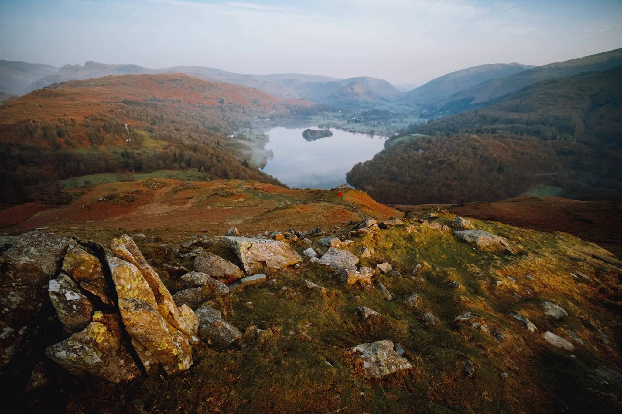
Nearly at the summit of Loughrigg, we look back to this cracking view of Grasmere, its namesake village, and the Central Fells.
The summit of Loughrigg Fell. With the sun clearly above the clouds, beautiful golden light drenched across the rolling folds of the fell.
A Herdwick ewe, enjoying the morning light. Not a bad view to chill out whilst chewing the cud, eh?
Another Herdwick ewe, lower down the slope. It’s a sheep’s life in the Lake District.
This Herdwick ewe, closer to us, was much more vocal. Probably warning the others about our presence.
The summit of Loughrigg is wonderfully craggy. My ultra-wide 9mm lens was able to fill the frame with this crag and also take in the extensive view towards Windermere.
We carefully picked our way back down the wet northern slopes of Loughrigg, stopping for the occasional photo along the way. This area of the fell was extensively mined for slate in the Victorian era, now long abandoned. Its remnants make for interesting compositions towards Nab Scar and Rydal Water.
This is Rydal Cave, formerly Loughrigg Quarry, and completely man-made. You can often find ducks and fish milling about in the shallow pools of the cave.
It’s not often one gets Rydal Cave all to oneself, so we ventured in for some photos.
Now back onto Loughrigg Terrace, the going is much easier as we saunter gently back towards the car through White Moss Woods. This particular aspect of Loughrigg Fell is called Ewe Crag.
An old barn, long fallen into disrepair and nature quickly reclaiming it.
Into White Moss Woods with gorgeous golden morning light streaming in.
Still a fair bit of colour in the woods. Soon, White Moss Woods will be absolutely full of bluebells. Give it a month or so.

Loughrigg, Lake District, Autumn
There are several Wainwrights that are considered key or “core” Wainwrights.
There are several Wainwrights—that is, Lake District peaks written about in Alfred Wainwright's seven-volume Pictorial Guide to the Lakeland Fells—that are considered key or “core” Wainwrights.
They include the likes of Catbells, Helvellyn, Scafell Pike, and the Old Man of Coniston.
You could also argue that Loughrigg Fell should be included as a core Wainwright, too. And in all my years of living in Cumbria I’ve never once been up this relatively small yet sprawling fell.
So, at 5:00am this morning, we changed that.
Loughrigg Fell, or just Loughrigg, is one of the smaller Lake District fells, measuring only 335 m or 1,099 ft (compare this to England’s highest peak, Scafell Pike, coming in at 978 m/3,209 ft). However, its mass covers a surprisingly large area near Central Lakeland. To its north are two lakes: Grasmere and Rydal Water. To its west the fell overlooks Loughrigg Tarn followed by Elter Water. East, the River Rothay runs through a shallow depression, and south of Loughrigg is England’s largest lake: Windermere.
Because the fell covers such a large area there are many ways to access its numerous crags and the summit. We arrived at a lay-by near the shore of Grasmere and set off for the fell at around 6:45am. We took the route through Penny Wood onto Grasmere “beach” and then up into Deerbolts Wood, before joining Red Bank and taking the steep pitched path up onto Loughrigg’s various nobbly crags.
The morning was clear and glorious, and we watched as the rising sun slowly lit up the various peaks you can make out from around the shoulders of Loughrigg, such as Wetherlam and the Langdale Pikes. By the time we hit the summit the sun had risen and was covering the rolling crags of Loughrigg in golden light.
What a cracking morning.
All photos shot on a Fujifilm X-T2 with a XF 18–55mm f/2.8–4.0 lens using a customised Classic Chrome film profile.
Looking back down the steep pitched path that was our route up to the summit of Loughrigg. Silver How (395 m/1,296 ft) starts catching the soft pre-sunrise light.
Loughrigg features lots of lovely crags from which you can take your pick of compositions towards the distant fells. Here I pointed the camera towards the Langdale Pikes as they started to glow.
I find another or Loughrigg’s crags, surrounded by autumnal fern, which I use to point towards Wetherlam as it glows pink.
Higher up we can better make out the Langdale Pikes and Crinkle Crags (859 m/2,818 ft) as more of the land is bathed in warm sunrise light.
Another crag offers a framing and leading device for a composition towards Dunmail Raise, north of Grasmere village.
My lovely Lisabet takes a pew on some crag and enjoys the views as more of the fells light up in the sunrise glow.
A beautiful Herdwick yow (ewe) stares at us curiously with its smiling face. Behind her are the glowing slopes of Lingmoor Fell (469 m/1,539 ft).
The Rydal Fells, which ultimately lead up to Fairfield (873 m/2,864 ft).
Looking up the undulating folds towards the summit of Loughrigg, marked by a trigpoint.
I wanted to capture the criss-crossing and layering of the land as the sun rose over the fells.
Looking back at the route up to the summit of Loughrigg. In the distance is Grasmere village and the fells north of it: Helm Crag, Steel Fell, and Seat Sandal.
From the summit of Loughrigg you can finally make out some of Windermere lake.
From the summit you can enjoy a clear view of Wetherlam (763 m/2,502 ft), which I shot from the summit’s crags.
Probably my favourite photo from the whole hike.
Another ewe enjoys the views from one of Loughrigg’s crags.
The rolling craggy landscape of Loughrigg as the walking trails meander towards Windermere.
Lisabet inches closer for a better snap of the ewe and her lamb.
Incredible views from Loughrigg towards Elter Water and Wetherlam above.
Up in the Lakeland Fells autumn has arrived as the fern on the fell slopes turn a beautiful rusty colour.
A lone Herdwick ewe munches on the bracken in a steep gully below the rolling crags of Loughrigg.
Near Loughrigg’s northeastern slopes you can find increasing evidence of quarrying. Here we found a deposit of slate, forming a little mound of its own.
Tracking the outcrops of rhyolite and basaltic andesite towards the Scandale fells.
Lisabet pauses to enjoy the views as we navigate our way down the slopes of Loughrigg.
Back onto the main path that circumnavigates Loughrigg, known as the Loughrigg Terraces, we find Rydal Cave. This is a man-made cave; created as consequence of quarrying slate for roofing material.
A pool has filled Rydal Cave, offering crisp reflections that I played around with.
We spotted teeny little fishes in the pool too! Couldn’t say what they were, though.
Back on the main path around Loughrigg and looking up at Ewe Crag.
Into the woods alongside the River Rothay we chanced upon a couple of Herons. One of them flew off almost immediately but this one, hunched up, stayed on its perch long enough for me to get this quick snap.
In Penny Wood we notice that Grasmere is offering some crisp reflections of Silver How, which clamber down to get shots of.
All in all a 10/10 morning.