
Hawes, Yorkshire Dales, Summer
A Bank Holiday Monday meant a day out with me Dad.
A Bank Holiday Monday meant a day out with me Dad.
After heading down to Kendal to meet me we decided to let his new car “stretch its legs”, so head east into the Yorkshire Dales. A wander around Hawes and the beautiful Upper Wensleydale was in order.
It’s been a while since I’ve wandered around Hawes, and I was stunned by how busy and seemingly thriving it was. Hawes has always been popular with bikers anyway, but beyond the regulars there were scores of people enjoying the sights of what Hawes has to offer.
We timed it well, too. Not long after leaving Hawes via Blea Moor Road and the Ribblehead Viaduct, the heavens opened and the rain fell.
All photos taken on my Sony α7ii using my Sony FE 28–70mm f3.5–5.6 OSS and Vivitar “Series 1” 70–210mm f2.8–4.0 zoom lenses. RAWs were developed in Lightroom for iPad using RNI Films’ Kodachrome film profiles.
Hawes, Yorkshire Dales, Summer by Ian Cylkowski is licensed under CC BY-NC-SA 4.0![]()
![]()
![]()
![]()
Hawes was so busy that we couldn’t find any parking within the town. We had to stop outside the eastern end of the town. Thankfully, that afforded us views down Wensleydale like this.
A proper bucolic northern English scene, with the characteristic golden sandstone buildings of Hawes with the crags of High Clint in the distance.
One of Hawes’ most well-known scenes. Gayle Beck flows north from Sleddale and through Hawes town centre, dropping here as a beautiful series of falls.
One of many independent shops in Hawes, some have been here longer than others.
Hawes has an almost timeless aspect to it, save for the bright blue bins of course. No matter where you look, you can always see the fells of Upper Wensleydale.
There were plenty of crochet sheep and yarn bombing all around Hawes, raising funds for Great Yorkshire Ambulance.
Look at these fantastic woollen renditions of Wallace and Gromit! Wallace & Gromit is a stop-motion animation franchise, and Wallace became well-known for his love of Wensleydale Cheese. It can be argued that the renewed interest in this cheese, courtesy of Wallace & Gromit, was what saved the Wensleydale Creamery from bankruptcy.
I couldn’t resist immortalising this timeless scene. I wonder how long they’ve been going for?
We wandered up the road towards Gayle to take in a loop of the town and get some higher vantage views of it. Here, the road points the way towards Wether Fell (614 m/2,014 ft).
The cap of Yorburgh with a pair of trees point towards it.
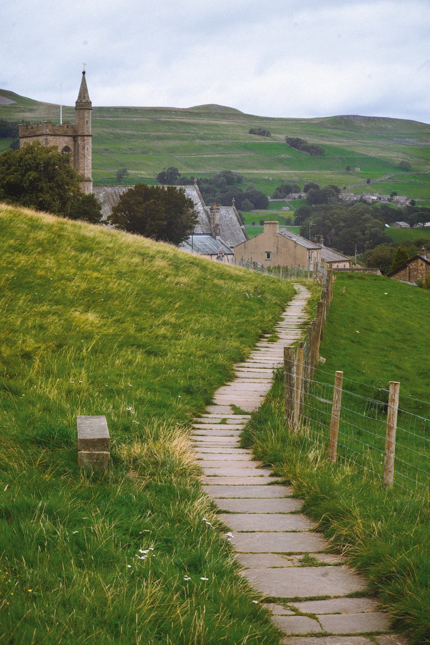
The well-maintained path takes you around the back of Hawes and opens up the views from above it. Here, the path serves as a leading line past St. Margaret’s Church and over the buildings of Hawes, with the nub of Smuker Hill, part of Lovely Seat, visible.
I love capturing timeless rural scenes like this. Hawes makes it very easy.
Taking the little back yards of Hawes makes you feel like you’ve stepped back in time.
Did you enjoy these photos?
Clougha Pike, Forest of Bowland, Lancashire, Summer
The last few weeks have been… tough.
The last few weeks have been… tough.
Not long after our hike to and around Stockghyll Force, I managed to acquire some form of vertigo for a few days, which was decidedly unpleasant. The following week, my lovely Lisabet came down with a rather nasty summer cold, and I managed to fall down the stairs, spraining my wrist and severely bruising my butt. Then the week after, I caught Lisabet’s cold.
Yeesh.
Finally though, we were both fit and healthy, ready to get back out in nature. Following wise counsel from our nature expert friend, Andrew, we embarked on a completely new hike for us: the Clougha Pike circular.
Clougha Pike is the westernmost summit in the Forest of Bowland Area of Outstanding Natural Beauty. Many peaks in the Forest of Bowland are gristone fells surrounded by heather-covered peat moorland, blanket bog, and deep wooded valleys. Clougha Pike is no different, though its southern face drops away dramatically to the valley floor, and is clearly visible from most areas around Lancaster.
I ended up being in rather a lot of pain for this 10km hike. For reasons unknown to me, I slowly developed a blistering headache as the hike went on. This was paired with a sore neck (from having to look down at my footing a lot), sore knees (an every day occurrence), and painful feet (soles in my boots are now too thin).
Oh also, around the lower areas of the walk, having to deal with all the sheep flies and deer flies.
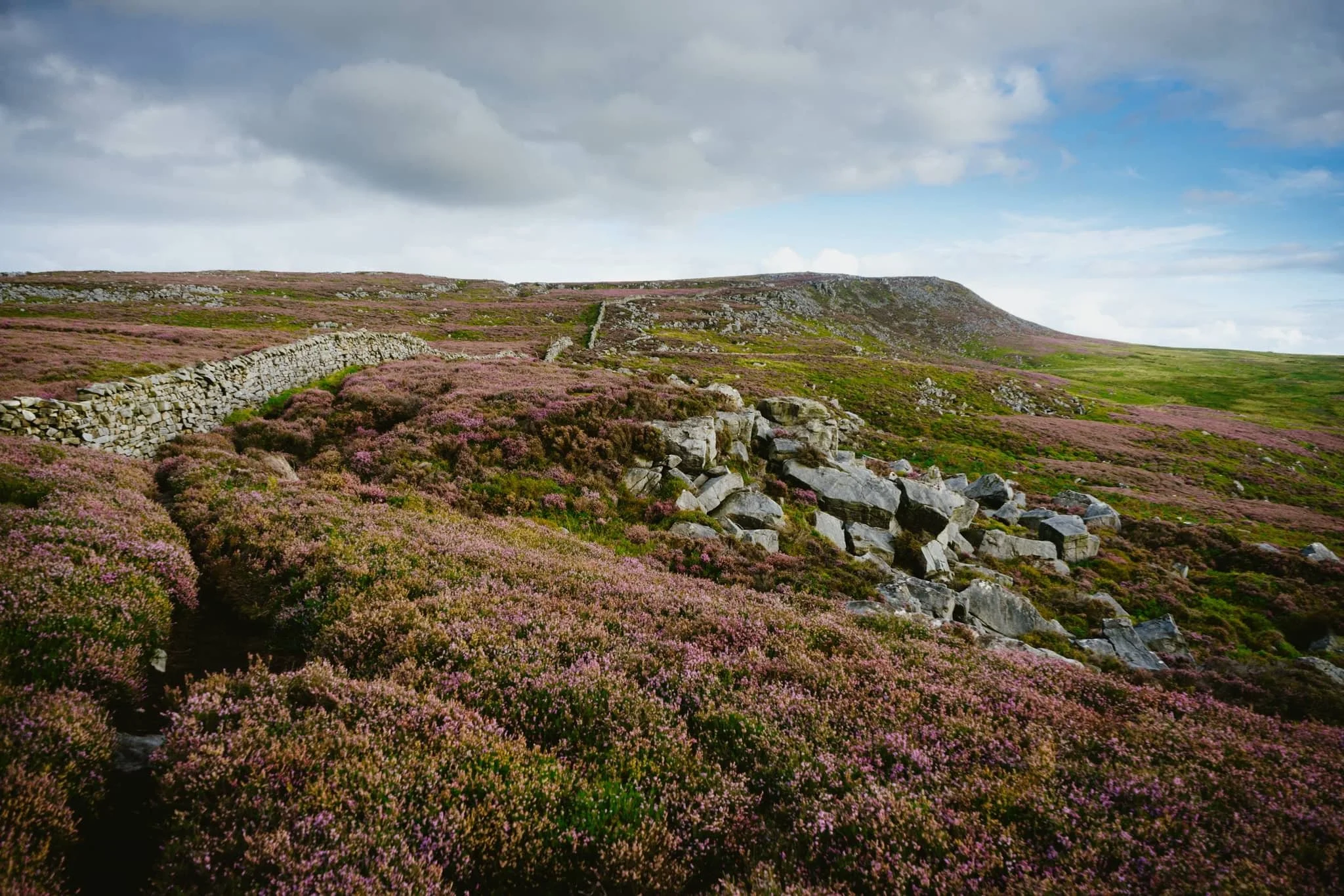
Despite all of this, the hike was gorgeous. The heather was in full bloom, covering the land and fells in carpets of mauve flowers. We were also experiencing the tail end of Storm Betty, so the higher we ascended the more the 50 mph winds punched our bodies.
All in all, it made for an epic day, and crackin’ photos.
Photos taken on my Sony α7ii using my Sony FE 28–70mm f3.5–5.6 OSS zoom lens. RAWS developed in Lightroom for iPad using RNI Films’ Fortia SP film emulation, then finalised in Affinity Photo 2 for iPad.
Clougha Pike, Forest of Bowland, Lancashire, Summer by Ian Cylkowski is licensed under CC BY-NC-SA 4.0![]()
![]()
![]()
![]()
Just a few yards from the car park and already we could see the extent of all the pinky purple heather blooming in the area.
This trail is the more direct route up to Clougha Pike. But for our hike, we chose a more circular clockwise route, skirting around the old quarries and heading towards Littledale.
The colour contrast between the heather and the grasses was proving too hard to resist.

A small scene of a gristone boulder being enveloped by all the heather, fern, and other moorland vegetation.
Increasingly I delight in finding, composing, and shooting these more intimate scenes in nature.

Miles upon miles of heather moorland give way to the lower folding valleys near Quernmore.
This point marked the beginning of our ascent of the fellside above Littledale, the site of a former quarry.
After crossing the infant River Conder via a concealed viaduct now known as Ottergear Bridge, we continued ascending the fellside above Cragg Wood. In the distance, Caton Moor’s windfarm catches the emerging light.
The trail gently lowered back down the fellside, but not before I captured this delightfully bucolic English view.
Another ascent ahead of us, the time the proper one that takes us all the way up to the Clougha Fell moorland plateau. The cascades of Sweet Beck presented a lovely little composition.
A swaledale yew enjoys the view from the fellside above Sweet Beck, with Caton Moor still drenched in light.
As we start ascending the back of Clougha Fell, the greens of the grass is gradually replaced the pinks of heather and the dark tones of peat, punctuated with boulders of gritstone.
The Caton Moor windfarm still getting soaked in afternoon light. In the distance, the dark clouds press down on the southwestern fells of the Yorkshire Dales.
After tacking the tricky and occasionally boggy trail up the back of Clougha, we finally joined the gravel shooter’s track and the moorland plateau. Rather then heading straight for the summit, we looped around to check this Andy Goldsworthy sculpture.
Of course, we had to take turns clambering into the “chambers” for some photos. The nice thing is, in the 50+ mph winds, these chambers were a nice respite from being constantly wrestled by the wind.
Making our way onto Clougha Fell, I had lots of fun making compositions from all the gritstone formations dotted about everywhere, such as with these boulders and the Yorkshire Dales Three Peaks in the distance.
A gritstone platform with solitary boulders, wrapped in heather, provided a nice scene towards Caton Moor and the dark fells in the distance.
It’s not quite Joe Cornish levels of composition skill, but I’ll get there one day.
A solitary gritstone boulder perched on the moorland plateau serves as a nice subject as it catches the light beneath the stormy skies.
From the summit of Clougha Pike, a mere 413 m/1,355 ft above sea level. Nevertheless, the views are gorgeous. From the summit we can see all the way across the Lune valley, towards Morecambe Bay.
From the summit, our way back down was immediately apparent. It was going to be rocky and steep.

100 m or so below the summit of Clougha Pike, a patch of smoothed gritstone boulders interspersed with heather provide me with another tasty composition.
From below Clougha Pike’s southern face, it’s easy to see how this is such a distinct and recognisable hill from many miles away.
A blast of light from the racing stormy clouds pulls all the gorgeous textures and colours from this scene.
One last look back at Clougha Pike, with heather everywhere, but we continued the descent down into the woodland toward the car park, fighting flies all the way.
Did you enjoy these photos?
Stockghyll, Lake District, Summer
Lots of rain means one thing: waterfalls.
Loads of rain means one thing: waterfalls.
Though certainly not as numerous or epic as in the Yorkshire Dales, the Lake District is still home to some lovely waterfalls.
Certainly one of the more accessible, yet grand, waterfalls is Stockghyll Force in Ambleside. We last hiked around here in June 2020, just as the UK’s COVID-19 lockdown was starting to ease off. Ambleside, usually one of the busiest honeypots in all the Lake District, was eerily quiet on that visit.
Things were very much back to normal this time. Lots of people about, sipping pints in pubs, chatting over coffee and cake with friends, and hiking in and around the town.
And all the rain we’ve had in July has meant that Stockghyll Force should be in full flow. Boy did she look good.
All photos taken on my Sony α7ii using my Sony FE 28–70mm f3.5–5.6 OSS zoom lens. RAW files were corrected in Lightroom, developed using RNI Films’ Kodachrome film profiles, and finalised again in Lightroom.
Stockghyll Force, Lake District, Summer by Ian Cylkowski is licensed under CC BY-NC-SA 4.0![]()
![]()
![]()
![]()
From the car park opposite the Log House, we elected for the back roads towards the waterfall, rather than trekking alongside the main road. It gave us lovely, almost timeless, scenes like this.
Soon enough we exited the town centre, hiked up the road alongside the beck, and head into the woodland surrounding the waterfall. A lovely little weir, bathed in sunlight, made for a nice composition.
Further into the woods, a small beck flows underneath this delightful little bridge.
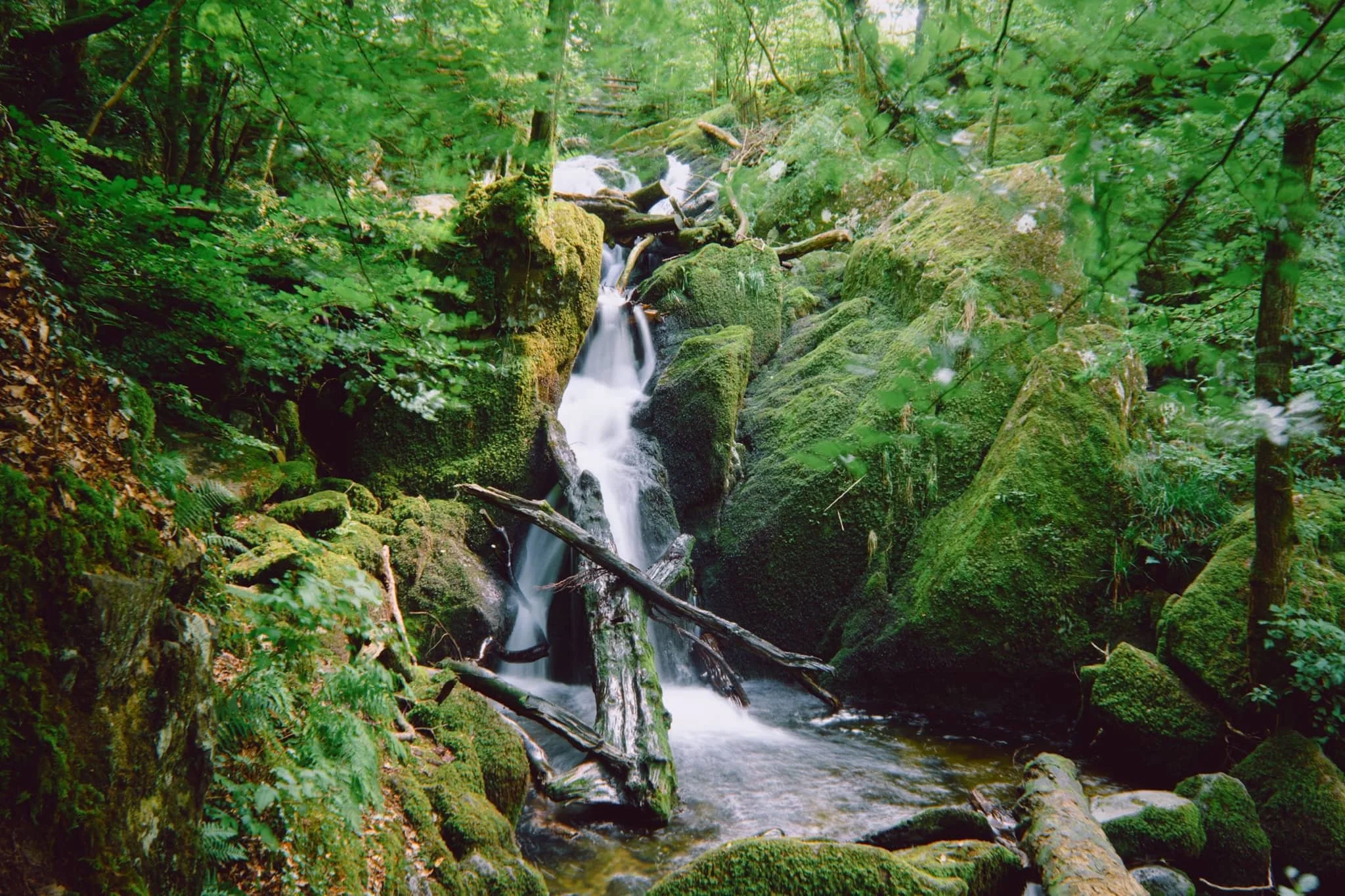
At the main waterfall itself, I perched myself and the tripod gingerly on a crag above the main drop, seeking a composition looking all the way down the falls to the gorge below.
The upper part of Stockghyll Force, surrounded by jagged, mossy crags and lush verdant vegetation everywhere.
After leaving one side of the trail, we took a lunch break at a new cafe that’s recently opened not 30 m away from the waterfall. Force Cafe. Delicious food and drink, and absolutely stunning views from their open terrace.
Heading back down the other side of the trail, the classic view of Stockghyll Force emerges and I cannot resist.
However, just a little further down the trail, I think the best view of Stockghyll Force can be obtained.
Did you enjoy these photos?
Hayeswater, Lake District, Summer
Here’s one we’ve not been to in quite some time.
Here’s one we’ve not been to in quite some time.
After June’s dry conditions and soaring temperatures, July has been unseasonably cool, stormy, and wet.
A succession of wet weekends exhausted our patience, so Lisabet and I braved the Sunday and head into the Lake District.
The initial plan was for a valley bottom walk around Grisedale, one of my favourite places in all the Lake District. However, as we approached Brothers Water, Lisabet suggested revisiting Hayeswater instead, and I heartily agreed.
The last, and only, time hiked up to Hayeswater was way back in June 2013. A lot has changed in a decade. For a start, despite being 10-years older, we’re both fitter. The hike up to the former reservoir was considerably easier than we remembered it.
Our journey into Hartsop and up to Hayeswater was punctuated with frequent downpours and brief bursts of localised light. It made the going tough, but boy did it make for epic photos.
All photos taken on my Sony α7ii with a Sony FE 28–70mm f3.5–5.6 OSS zoom lens. RAWs were developed and edited using RNI Films’ Kodachrome film emulations.
Hayeswater, Lake District, Summer by Ian Cylkowski is licensed under CC BY-NC-SA 4.0![]()
![]()
![]()
![]()
From Cow Bridge car park, Hartsop Dodd (618 m/2,028 ft) towers over you as you head towards the sleepy little hamlet of Hartsop.
Looking up Patterdale, another squall drenches Place Fell.
After passing through Hartsop, we’re greeted with this view of Gray Crag (699 m/2,293 ft) whilst a small flock of Swaledales eagerly keep their distance from us.
Looking up Pasture Bottom towards Threshthwaite Cove as a small gap in the cloud cover lets some light in.
Beyond Hartsop, the trail quickly gains height, opening up the views back across Patterdale to the Fairfield and Helvellyn fells.
Another big squall soon drenches the Patterdale fells. It would be our turn soon.
With the steeper part of the trail behind us, a brief pause allows me to compose this image of Lisabet heading onwards with Sulphury Gill streaming down the fellside and The Knott (739 m/2,425 ft) rising sharply above.
The ascension ceases. At Hayeswater, I zoom in on the sheer face of High Street (828 m/2,717 ft) as clouds blow across.
Hayeswater is natural in origin, but was dammed in 1908 to supply water for Penrith. In 2005 it ceased to be used as a reservoir, and in the summer of 2014 United Utilities removed the dam, restoring the natural form of the tarn.
We watched as waves of clouds washed across the fell tops.
After stopping for lunch in the pouring rain, we started making our way back down the trail. 250 yds from the tarn, a new bridge crosses the gill that allowed for some nice compositions.
The waves of rain eased off and soon the immense views across Patterdale to the Helvellyn fells revealed themselves to us. To the bottom-right of the image you can see the old Filter House, now a private residence.
Glad to vaguely dry, I started to relax as we made our way down the trail. Beyond, the cloud cover lifted from the fells.
A break in the cloud illuminated the fells, if only for a moment, and I was able to capture this epic scene.
Nearing the valley bottom, the shoulder of Hartsop Dodd is bathed in glorious golden light.
A tighter, zoomed in composition involving a drystone wall, pasture field, and Raven Crag.
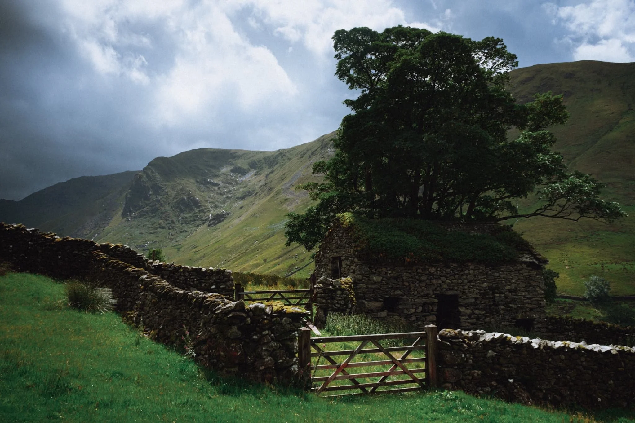
Beneath the towering form of Hartsop Dodd, this delightful barn captures our attention and imagination.
A beautiful scene of one of Hartsop’s houses with Hartsop Dodd looming above.
Perhaps the finest shot I got from the whole day. A dilapidated barn covered in a carpet of moss with a tree growing out of it. Beyond, a break in the clouds allows an intense burst of light to illuminate Raven Crag.
A true rural Lake District scene with the unmistakeable form of Hartsop Dodd keeping watch. The sky darkens as the clouds drop down and close in again.
We tried a different route back to the car park, passing by this gorgeous cottage as another wet squall starts to close the end of our walk.
Did you enjoy these photos?
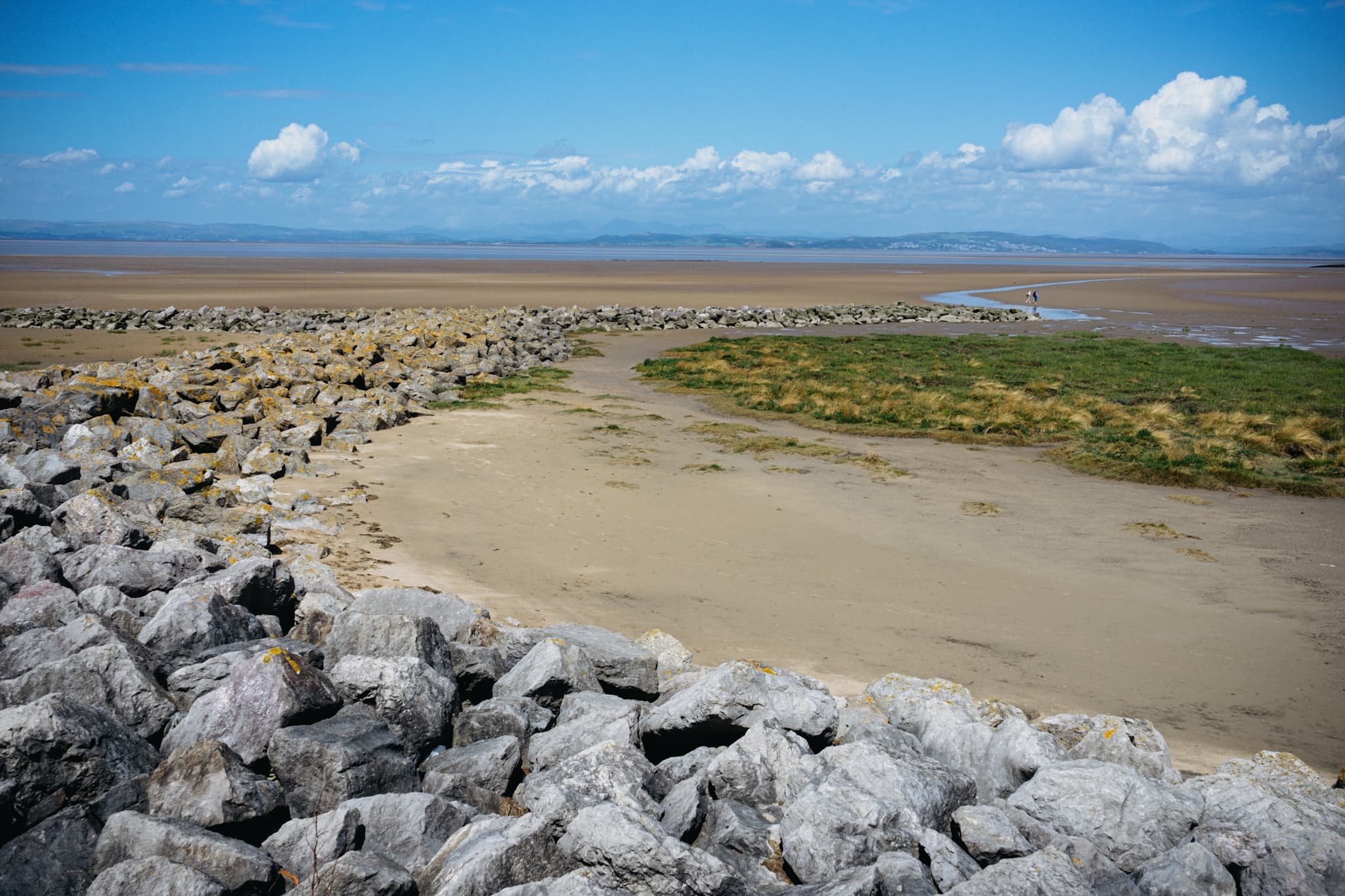
Morecambe & Heysham, Lancashire, Summer
After a thunderstorm, you need to get those vast and expansive views.
After a thunderstorm, you need to get those vast and expansive views.
On the Saturday, the Met Office issued a Yellow Warning of thunderstorms and torrential downpours. This was very much needed as temperatures were starting to creep up to the mid 20’s again with 90%+ humidity.
If there’s one thing a thunderstorm is really good at it’s clearing the atmosphere. So, on the Sunday, we decided that solid hike along the Morecambe Bay coast, from Morecambe to Heysham and back, was needed. The views across the bay to Cumbria and the Lake District fells are always welcome. Plus, we knew we would have limited time before the next load of thunderstorms arrived.
I decided to equip relatively minimally; just my camera, Sony 28–70 and Vivitar “Series 1” 70–210mm for those super tight and zoomed in compositions.
The views, and the weather, were glorious.
All photos taken on my Sony α7ii using my Sony FE 28–70mm f3.5–5.6 OSS and Vivitar “Series 1” 70–210mm f2.8–4.0 zoom lenses. RAWs developed in Lightroom for iPad using RNI Films’ Portra 160 film emulation, then a little bit of finalisation in Affinity Photo 2 for iPad.
Morecambe & Heysham, Lancashire, Summer by Ian Cylkowski is licensed under CC BY-NC-SA 4.0![]()
![]()
![]()
![]()
Want sweeping and expansive views for mountains in the distance? Morecambe Bay is where you need to be. Anywhere with access to the Bay will do, but for this walk we chose the town of Morecambe itself.
This is the 14 m tall Hook Beacon, signalling the location of West End Gardens at Morecambe Bay. It was conceived by Broadbent Studio in collaboration with local school pupils.
A man and his dog, watching the world go by.
We started the walk 1-hour after low tide, so the sea was still miles out. Families and couples alike were enjoying the sensation of wet sand on their feet and sea air in their faces.
I decided to equip my 70–210mm lens for some super-zoomed in compositions across the bay to Cumbria.
A lovely mural that I can never resist taking a shot of.
Nice and clear, the Coniston Fells in the Lake District, 25 miles away.
One of numerous breakwaters along Morecambe. This is Grosevenor Breakwater, with Black Combe (600 m/1,970 ft) rising in the distance.
It’s always nice to see people soaking in the vibes of the day and taking in the immense views that Morecambe has to offer.
South beyond the town of Morecambe, ancient Heysham comes into view, resting on a small hill above the Bay.
St. Peter’s church. Christian worship has been regularly practised at the site for over 1,000 years.
The graveyard behind the church enjoys spectacular views across the Bay.
Trees in the graveyard remind us of the passing of time beyond our own horizons.
The ruins of St. Peter’s chapel, dating from around the 8th or 9th century. It gives me vibes of a portal to another world.
A group of six stone-hewn tombs dating from around the 11th century. Each tomb has an associated “socket”, which was probably where a wooden cross would be inserted.
At Half Moon Bay, just before Heysham Nuclear Power Station, one can find the marvellous SHIP sculpture by Anna Gillespie.
The ship's hull is mounted with two opposing figures at each end. One faces "new" Heysham, the Nuclear Power Station, and the other faces "old" Heysham, the ancient monument of St Patrick's Chapel.
The sculpture "celebrates Morecambe Bay's landscape and maritime heritage, and reflects the importance of seaborne trade in bringing news, innovation and shaping the character of the area."
Heading back to Morecambe, I couldn’t resist nabbing the colour contrast of pink and green courtesy of these flowers.
The way back to Morecambe, with plenty of other peeps enjoying the day out in the glorious sunshine.
This gentleman was raising people’s spirits with tunes from his pocket trumpet. He was also kind enough to pose for a photo or two and give us a rendition of “Bring Me Sunshine”, an appropriate tune for the town of Morecambe.
Did you enjoy these photos?
Marsden, West Yorkshire, Summer
Time for somewhere a little different.
Time for somewhere a little different.
We’re as guilty as anyone of succumbing to the familiar. Conscious of this, Lisabet and I booked a long weekend somewhere we’d never explored before: the moors of West Yorkshire.
Our “base” for the weekend was the bonny village of Marsden. Much like the rest of West Yorkshire, Marsden was an important mill town known for the production of woollen cloth. The days of hard labour in mills, warehouses, and factories are over, but those grand old buildings remain. These days, Marsden is a vibrant and forward-looking place that enjoys a great food and drink scene, easy travel to Manchester or Leeds, and quick access to the beautiful moorland hills that surround it.
The weather wasn’t as kind to us on this particular break, with persistent and at times heavy rain following us for most of the weekend. We attempted a hike up a well-known local hill, Pule Hill, but quickly turned back as it became clear that the various trails up the hill would be too boggy for us.
Instead, we explored the gorgeous scenery around the Huddersfield Narrow Canal, and possibly the windiest shoot I’ve ever done at Buckstones Edge.
All photos taken on my Sony α7ii using my Sony FE 28–70mm f3.5–5.6 OSS zoom, Vivitar “Series 1” 70–210mm f2.8–4.0 zoom, and Rokinon 14mm f2.8 ED AS IF UMC prime lenses. RAWs converted in Lightroom, developed in Photomatix, and edited and finalised in Photoshop.
Marsden, West Yorkshire, Summer by Ian Cylkowski is licensed under CC BY-NC-SA 4.0![]()
![]()
![]()
![]()
On a small clearing above the canal, we captured an inkling of a view of Marsden and its old buildings and mills.
The Huddersfield Narrow Canal between Marsden and Slaithwaite features plenty of picturesque locks in lovely scenery. The canal itself, though only 20 miles long, has 74 locks.
The canal truly is narrow in name and nature. Near Standedge Tunnel, a splash of colour amongst the brickwork catches my eye.
Many sections of Huddersfield Narrow Canal are beautifully lush and verdant.
This is where Huddersfield Narrow Canal enters Standedge Tunnel, carrying watercraft through and underneath the Pennines. At 5.2 km long, 194 m underground, and 196 m above sea level, Standedge Canal Tunnel is Britain’s longest, deepest, and highest canal tunnel.
Our ultimate destination was Pule Hill above the tunnel, at 434 m/1,434 ft above sea level. Though ultimately we retreated from climbing the summit, we nevertheless got fantastic views of Marsden and the valley it sits in.
An old farm cottage that’s seen better days, but nevertheless enjoys fantastic views.
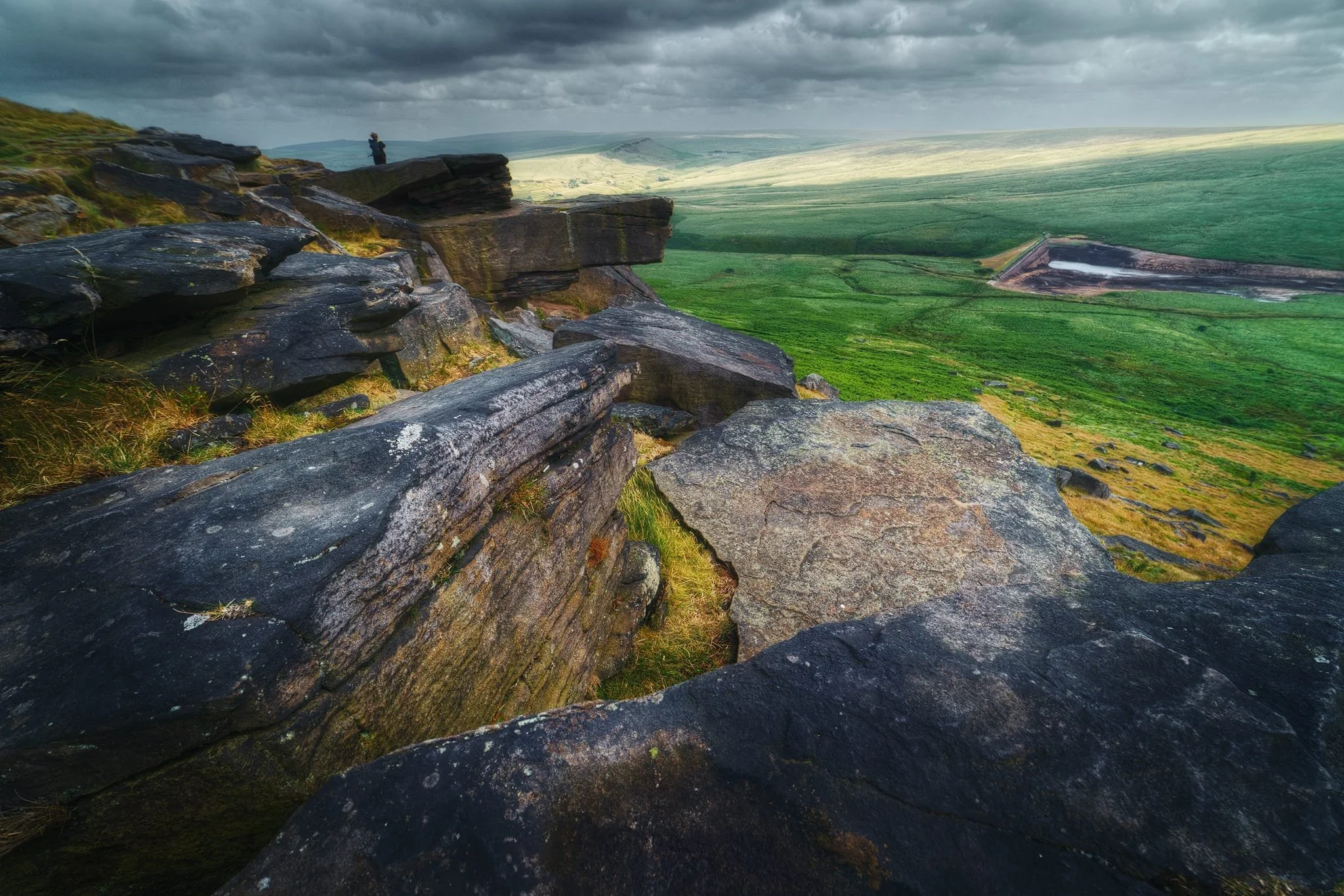
After clambering and squelching back down the valley into Marsden—and refuelling our bellies—we head up to Buckstone Edge. This rim of the valley above March Haigh Reservoir is lined with Millstone Grit crags and boulders that offer a photographer’s paradise of compositions.
At 1,400 ft above sea level, the wind was blowing a raging storm. Probably one of the windiest shoots I’ve ever done. I wanted to capture that sense of rushing and movement everywhere, contrasted against the still and stubborn boulders and crags.
As a result of the high winds, the clouds above us were rushing across the sky. This allowed for the sun to intermittently paint golden streaks of light across the land. All I had to do was watch, wait, and shoot.
I gingerly clambered down the steep valley side, seeking compositions of the Buckstones pointing towards Pule Hill in the distance.
Some of these Millstone Grit boulders were as big as a car, stubbornly resisting the sheer force of the day’s wind.
After satiating my need for ultra-wide compositions, I equipped my 70–210mm lens for some tighter images. Trying to get a steady shot at 210mm with the wind wrestling my camera was definitely a challenge. Some how, I managed a few sharp images!
Pule Hill, which defeated us earlier in the day. Here, at 210mm, it caught the sun’s fleeting paintbrush as I pressed the shutter.
Beyond the village, I spy the distant hills of Marsden Moor receiving their share of the sun’s brief artistic spurt, and set up a composition at 210mm with the Buckstones.