
Stanley Ghyll Force, Lake District, Spring
After a sobering return from a beautiful week in the Highlands, it was time for a beautiful little jaunt in Eskdale.
After a sobering return from a beautiful week in the Highlands, it was time for a beautiful little jaunt in Eskdale.
I was also due to hang out with me Dad again. After arriving at Dad’s, he suggested checking out Stanley Ghyll Force, one of the Lake District’s largest waterfalls. I were game for that!
Stanley Ghyll Force is located in Eskdale, a gorgeous valley in the southwestern corner of the Lake District. The last―and only―time I visited Stanley Ghyll Force was back in 2017. I know this because I shot the waterfall with a Sigma dp0.
Back then, I was all on me own attempting to navigate a tricky gorge. However, on that occasion, I was able to get right to the bottom of the falls for some cracking.
A lot has changed in the intervening 5-6 years. For a start, you can’t get to the bottom of the falls anymore. The path has eroded and collapsed to the point that it’s too dangerous. Instead, the Lake District National Park have created an alternative route that scales up the sides of the gorge so that you can get above the falls. In addition, they’ve also cut back hectares of invasive rhododendron and constructed a fantastic viewing station above the gorge.
We enjoyed some fantastic light, and I had a grand day out with me Dad.
All photos taken on my Fujifilm X-T2 using my Vivitar “Series 1” 28‒105mm f2.8‒3.8 zoom, Super Ozeck 80mm‒210mm f4.5 zoom, and Laowa 9mm f2.8 ultra-wide prime lenses. RAWs developed in Capture One for iPad, edited in Affinity Photo 2 for iPad.
Stanley Ghyll Force, Lake District, Spring by Ian Cylkowski is licensed under CC BY-NC-SA 4.0![]()
![]()
![]()
![]()
The gorge that contains Stanley Ghyll Force is wonderfully mossy and vibrant. Here, a pocket of light illuminates a boulder field exposed in the woodland.
We passed a small tributary beck that was catching some wonderful light in the gorge.
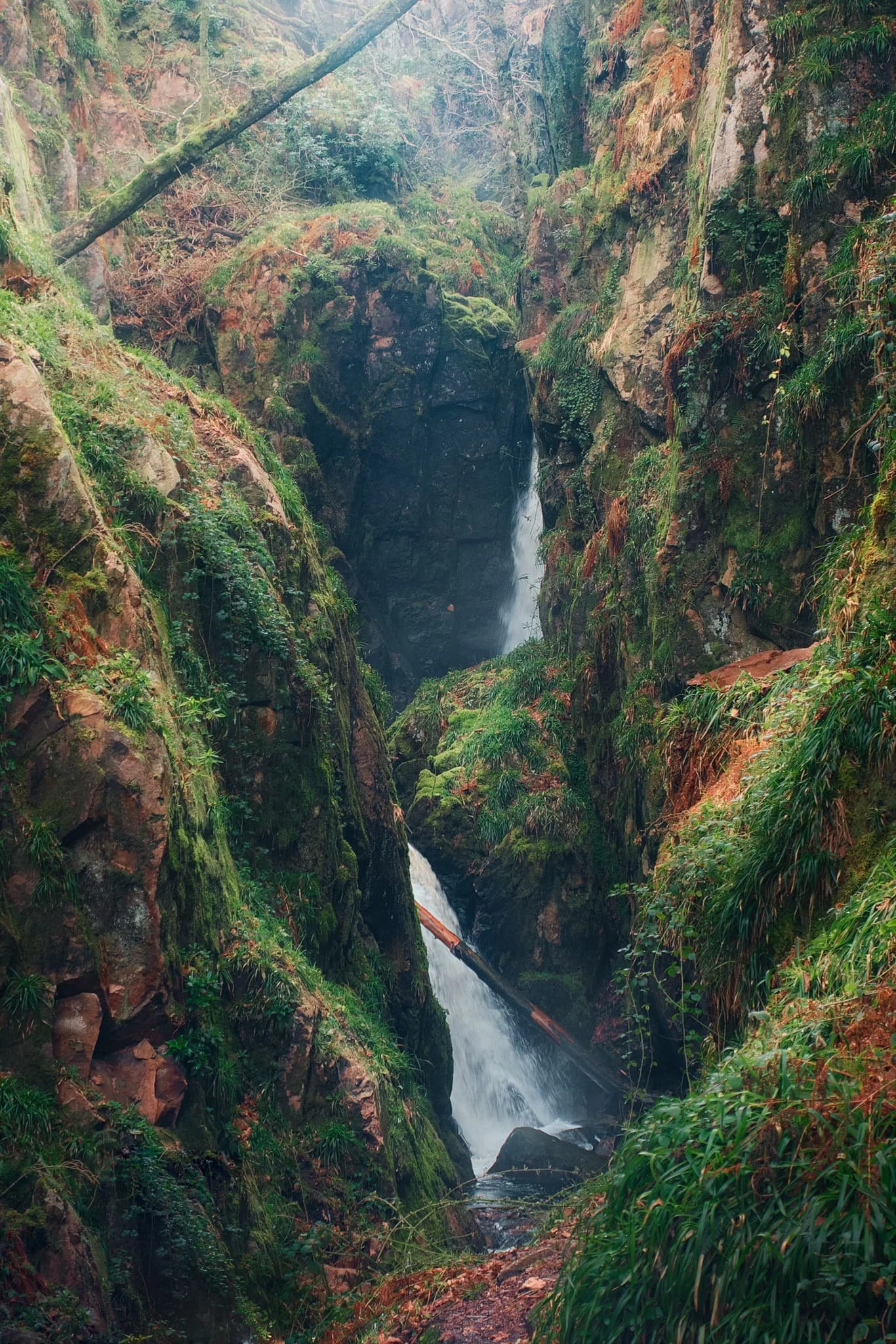
Eventually, the glory of Stanley Ghyll Force came into view. This was as close as we were allowed to get to it. Still some absolutely crackin’ light flooding into the gorge though.
After hiking up the new path made by the National Park, we found the new viewing station to check out the views it offered. And… wow. A sheer 150ft drop pulls your down the gorge and towards Stanley Ghyll Force. What a sight.
We followed the return track back down to the valley. As we did, me and Dad spotted some incredible light playing out on the distant Eskdale fells, and stopped to shoot photos like crazy.
Did you like these photos?
Oban, Argyll & Bute, Scotland, Winter
We’ve only ever been to Oban once before.
We’ve only ever been to Oban once before.
This was way back in Autumn 2014, when we first went into the Highlands of Scotland. On a particularly murky, misty, and wet day we drove away from the mountains and instead went to check out the nearest major town: Oban.
On that occasion, we were unimpressed. The place seemed drab and down on its luck.
On this trip, we decided to revisit Oban now that we had great light and clear blue skies. Oh boy, did we completely misjudge Oban. It’s a beautiful little town that enjoys terrific sea views across to Kerrera Island and the Isle of Mull beyond. It also enjoys lovely independent shops, top cafés, and gorgeous restaurants.
Amazing what better weather and 10 years can do.
All photos taken on my Fujifilm X-T2 using my Vivitar “Series 1” 28–105mm f2.8–3.8, Laowa 9mm f2.8, and Super Ozeck 80–205mm f4.5 lenses. RAWs converted in Capture One for iPad, developed using RNI Films’ Kodachrome film profiles, and finalised in Affinity Photo 2 for iPad.
Oban, Argyll & Bute, Scotland, Winter by Ian Cylkowski is licensed under CC BY-NC-SA 4.0![]()
![]()
![]()
![]()
Round the corner from where we parked, Oban Distillery is a beautiful building. The distillery was established in 1794, before there was even a town around it.
Our first order of the day was to hike up the hill behind Oban to check out the area’s most well-known landmark, McCaig’s Tower.
The way to McCaig’s Tower. It was built in 1897, commissioned by wealthy banker John Stuart McCaig as a monument to his family and to provide work for the local townsfolk. He was also the tower’s architect.
Out of the tower’s western side, you can enjoy expansive views across the Inner Firth of Lorn towards Kerrera Island and the Isle of Mull. Regular ferry trips courtesy of CalMac are available to the various islands near Oban.
One of these days we’ll have to check out some of the small isles you can visit from Oban.
McCaig’s Tower has 94 lancet arches, one of which I utilised as a literal compositional frame towards the mountains on the Isle of Mull.
Mr. McCaig commissioned the building of the tower at a cost in 1897 of £5,000 Sterling… that’s over £500,000 in today’s money.
The tower was built between 1897 and 1902, when Mr. McCaig died of a cardiac arrest. Construction of the tower promptly stopped, with only the outer walls completed.
Mr. McCaig planned for a museum and art gallery with a central tower to be incorporated. Inside the central tower he wanted to commission statues of himself, his siblings and their parents. None of this happened due to his death and the contesting of his Will. Nevertheless, I like that inside the tower a garden has been allowed to form.
Back down at the shore we gently meandered around the town’s coastline, looking for shots before stopping for lunch.
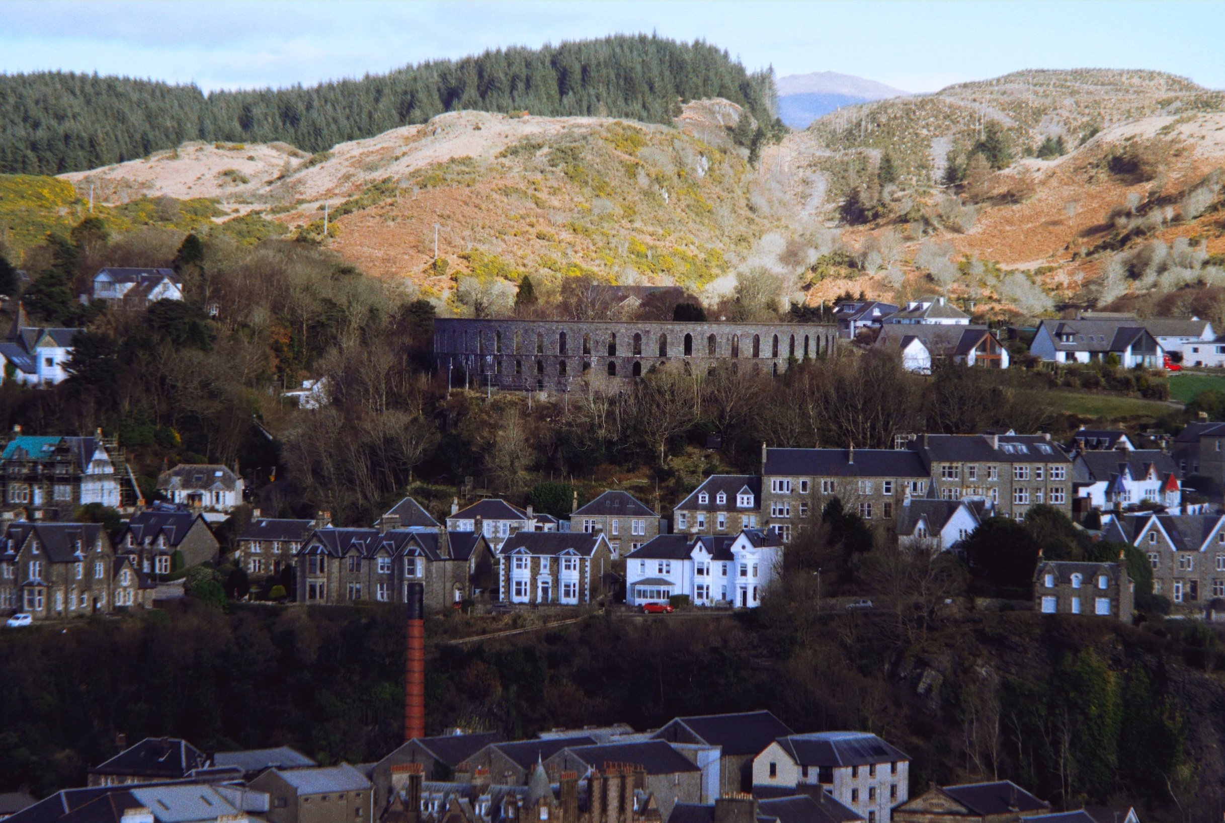
After a delicious lunch at Ee-Usk (which included the freshest oysters I’ve ever had), our next plan was to head up another hill above the town: Pulpit Hill.
A short and sharp climb up onto Pulpit Hill gave us tremendous views of the town, like this. Even from here, McCaig’s Tower is easily visible, as is the Oban Distillery’s bright red chimney.

From this vantage point I hastily equipped me Super Ozeck 80–205mm zoom lens for long compositions. The day was so crisp you could even make out Ben Cruachan (1,126m/3,694ft), 26-miles away.
Zooming in across the Inner Firth of Lorn. Bottom left is the northern tip of Kerrera Island, followed by the tiny islet of Maiden Island in the centre. In the distance is the uplands of the Isle of Mull.
Along the northern coastline of Oban one can find the ruins of Dunollie Castle, which enjoys a great lookout towards the uplands on the Isle of Mull. There’s been a fortification where the castle sits since the Early Middle Ages, but the current ruins date from the 12th or 13th century.
A super-zoomed in shot of upper Oban, with McCaig’s Tower visible and the craggy uplands above.
Hutcheson’s Monument on Kerrera Island, acting as a beacon pointing the way towards the Isle of Mull.
Did you enjoy these photos?
Pendragon & Lammerside Castles, Mallerstang, Yorkshire Dales, Winter
If the weather’s not going to improve, time to go somewhere that suits it.
If the weather’s not going to improve, time to go somewhere that suits it.
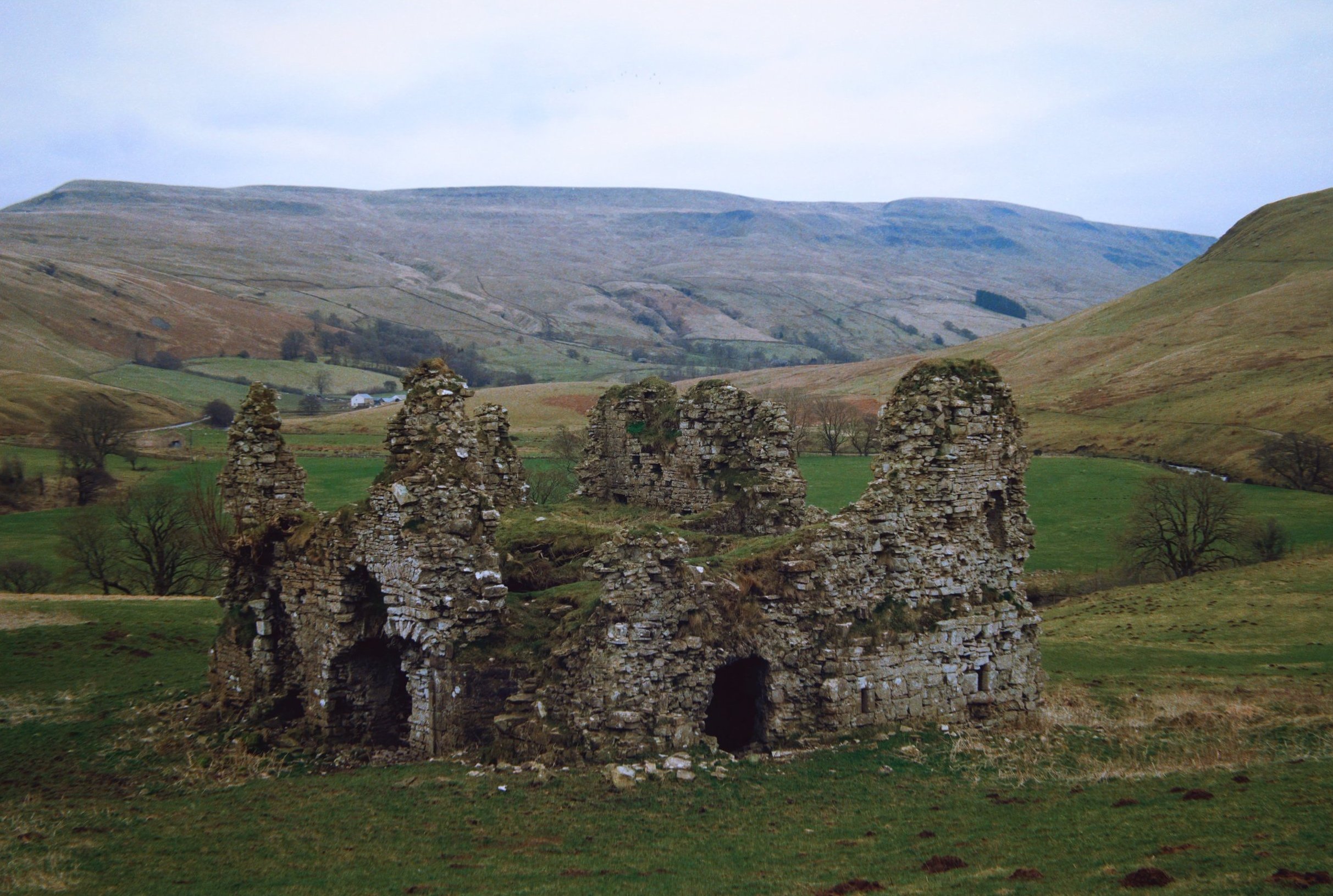
Regular readers of this site may know that Mallerstang, technically part of the Yorkshire Dales, is one of my favourite places in Cumbria. Typically my hikes in the valley explore the region south of Wild Boar Fell. However towards the northern part of the valley, as it starts to flatten out, one can find a historical gem: Pendragon Castle.
Unbeknown to both myself and Lisabet, there is another castle ruin further north of Pendragon, known as Lammerside Castle. So, we picked out a hike we could do that would take in both Pendragon and Lammerside Castles, and perhaps also check out Wharton Hall.
Although the forecast suggested skies would brighten up as the day went on, above Mallerstang the sky was resolutely cloudy and grey. No biggie. It just added to the mood of the scenes.
All photos taken on my Fujifilm X-T2 using my Vivitar “Series 1” 28–105mm f2.8–3.8, Super Ozeck 80–205mm f4.5, and Laowa 9mm f2.8 lenses. RAWs converted in Capture One for iPad, developed in RNI Films, finalised in Affinity Photo 2 for iPad.
The ruins of Pendragon Castle, looking particularly moody with the bare branches eerily pointing towards it.
It’s been about a decade since I last explored the ruins of Pendragon castle. This was in the prime of HDR days, where I didn’t go anywhere without a tripod and shot almost exclusively with an ultra-wide lens. With experience and developed eyes, I could spot compositions I’d never seen before.
Zooming in tighter, I pick out a delightful composition involving the crumbling ruins of Pendragon castle framing the shapely peak of Wild Boar Fell.
Circumnavigating the ruins, I look for compositions involving the ruins and the fell on the other side of the valley, Mallerstang Edge.
Legend says that the castle was built by Uther Pendragon, father of King Arthur. More accurately, the castle was built in the 12th century by Ranulph de Meschines, a Norman magnate.
A winding drystone wall leading to a fell? I couldn’t say no…
Even better if it’s a winding drystone wall involving castle ruins.
Following the Pennine Bridleway towards Lammerside Castle, I equip my 80–205mm lens for long tele shots of the distant Northern Pennines.
Eventually the ruins of Lammerside Castle come into view, seemingly not as grand as Pendragon Castle.
In the valley below us, sheep mill about aimlessly. One in particular spots me and gives me a good hard stare.
By the River Eden, swimmers warm up after a spot of outdoor swimming in what must be an icy cold river.
Scanning around and above the ruins, I can see incredible compositions revealing themselves to me.
The winner from the day. Some of the 2nd storey of the ruins survive, but nature is quickly reclaiming it. In the distance, Mallerstang Edge lines the top of the frame.
Time to slap on the 9mm ultra-wide. The closest crumbling wall looks like a human head, don’t you think?
The largest surviving archway into the ruins. I didn’t want to risk heading inside though.
This was about as far as I dared venture into the ruins. Amazing that the stonework has survived this long.
Compared to Pendragon Castle, not much is known about Lammerside Castle. It was probably built, similarly, in the 12th century but considerably fortified in the 14th century to protect against Scots raiders.
I could easily bang my head against the top of this archway. Makes you realise how much smaller people used to be.
Above Wharton Hall as we turned to head back, Lisabet quickly made friends with the local horses.
At Bullghyll farm, a friendly chicken hops up onto the wall for a friendly greeting.
A meandering beck snakes down from Birkett Knott above.
Following the Pennine bridleway back to Pendragon Castle, the magnificent peak of Wild Boar Fell makes its presence known once again.
Gnarly trees beautifully frame Cocklake Barn as we near the return to Pendragon Castle, 16,000 steps later.
Did you enjoy these photos?

Blelham Tarn, Lake District, Winter
Time for somewhere new (to us).
Time for somewhere new (to us).
In all my time of living in Cumbria and visiting the Lake District, I’ve never set foot near one of the Lake District’s most popular attractions: Wray Castle.
Wray Castle is perched on the high ground above Windermere’s western shore. Built in 1840, it’s not actually a castle but a private home. It was built for a retired Liverpool surgeon who commissioned it. Apparently his wife, upon completion, refused to live in it.
Nearby, one can enjoy a plethora of walks, all with their own charm and views to offer. On this occasion we elected for the Blelham Tarn walk, a valley tarn that drains off into Windermere.
The weather, for a brief period, threatened to brighten up but soon the clouds came down and signalled the end of the day’s hiking.
Definitely one to revisit in the spring or summer.
All photos taken on my Fujifilm X-T2 using a Vivitar “Series 1” 28–105mm f2.8–3.8 and my new Super Ozeck 80–205mm f4.5. RAWs converted in Capture One or iPad, developed using RNI Films, and finalised in Affinity Photo 2 for iPad.
Blelham Tarn, Lake District, Winter by Ian Cylkowski is licensed under CC BY-NC-SA 4.0![]()
![]()
![]()
![]()
Before setting off for the Lake District, Lisabet and I found—then purchased—a Super Ozeck 80–205mm f4.5 lens. As it was made for the Pentax K mount, and I have a Pentax K–Fuji X mount converter, it works flawlessly with my Fujifilm X-T2. Now I could zoom all the way into 205mm!
Stricklandgate and Windermere Road, shot from all the way up in Kendal town centre. Pretty damn chuffed with this purchase!
After arriving at Wray Castle, the views immediately opened up across Windermere.
This was about as good as the light got, but I’ll take it. Windermere with a slither of light scanning across the flanks of Wansfell Pike.
The splendour that is the Gothic Revival style of Wray Castle. Complete with inaccessible turrets and slit windows you could shoot fictitious arrows from.
A watch tower of sorts guards the entrance to the grounds of Wray Castle.
Before we could spot Blelham Tarn, Latterbarrow (245m/803ft) made itself immediately known to us. This is definitely one we’ll tackle in the near future.
My new Super Ozeck lens apparently has Macro functionality, so I decided to test it on some otherworldly lichen on a dead tree trunk.
On the higher ground south of Blelham Tarn, more panoramic scenes emerged with Wansfell Pike look tall and proud.
The memories of autumn cling on to the sides of a small beck.
Definitely a composition I need to return to when conditions improve.
The watch tower signals our return back to Wray Castle, 3-miles or so later.