
Llyn y Fan Fach, Brecon Beacons, South Wales, Autumn
If I had one main personal goal for this fortnight in South Wales we’re enjoying, it’s to get up one of the mountain ranges in the Brecon Beacons National Park.
If I had one main personal goal for this fortnight in South Wales we’re enjoying, it’s to get up one of the mountain ranges in the Brecon Beacons National Park.
There’s a few mountain/hill ranges in the Brecon Beacons National Park, the main two I was interested was either:
The Brecon Beacons, at the heart of the national park, which includes South Wales’ highest peak Pen y Fan (886 metres/2,907 feet)
The Black Mountain, sometimes known as the Carmarthenshire Fans.
On this occasion, we elected to hike up the Black Mountain range above the mountain tarn known as Llyn y Fan Fach.
The day promised to be glorious, with puffy white clouds and strong sun in the crisp autumn air. Though we were disappointed at the sight of Llyn y Fan Fach halfway up the climb (it seems to be in the process of being emptied), the views on the way up to the peaks were absolutely astounding.
All photos taken on my Fujifilm X-T2 using my Vivitar “Series 1” 28–105mm f2.8–3.8 zoom and Laowa 9mm f2.8 prime lenses. RAWs converted in Capture One for iPad, developed and finished in Affinity Photo for iPad.
Llyn y Fan Fach, Brecon Beacons, South Wales, Autumn by Ian Cylkowski is licensed under CC BY-NC-SA 4.0![]()
![]()
![]()
![]()
After exiting a busy car park we started the ascent up the Beacons Way path direct towards the tarn. Looking to the east I nabbed this quick shot of the criss-crossing hills towards Bryn Blaen-Wysg.
About halfway up the path is a small hut where the dam is. Above it are these fish hatcheries which were originally used as filter beds. The rounded hills at the bottom of the path are in stark contrast to the shapes of the Black Mountain, as you’ll see.
As we climb the views get ever more extensive. The last time we visited Llyn y Fan Fach, back in October 2018, there were few people around. This time the car park was full and cars had been dumped on the grass verges along the road leading to the car park. Apparently this area became vastly more popular after being featured in a 2020 TV series “Secrets of Britain”.
From the left, Fan Brycheiniog and Picws Du come into view, with their heavily glaciated and steep northern craggy faces. Morning sun was attempting to break through the clouds above.
Wow, am I right? After seeing the state of Llyn y Fan Fach, we quickly continued our ascent up the Black Mountain. The views looking back to the peaks were too incredible to ignore. The tallest peak, Fan Brycheiniog, is on the left, or strictly speaking its “nose”, Fan Foel. This is followed by Picws Du, Cefn Twrch, and Waun Lefrith.
The hike up the western slopes of the Black Mountain is steep, and the drop down to the tarn is sheer… but I mean, look at those views. The light got more intense, too, as the clouds started to dissipate and reveal the sun.
These peaks are primarily composed of Old Red Sandstone, laid down around 400 million years ago, with bands of Carboniferous Limestone. I wanted to find some of the exposed red sandstone as a contrast to all the grass.
More cracks of ruby red sandstone which I wanted to emphasise with a vertical composition towards the Black Mountain peaks.
My lovely Lisabet, being immensely more brave than I as she stands atop an exposed crag with a 500ft sheer drop beneath her.
This was about as close as I dared go to those crags, with the beautifully curved glaciated wall of Waun Lefrith in the distance.
Did you like these photos?

Llandovery & Cwm Rhaeadr, South Wales, Autumn
If there’s a feature that—to my mind—typifies South Wales that isn’t it’s glorious coastline, it’s the waterfalls.
If there’s a feature that—to my mind—typifies South Wales that isn’t it’s glorious coastline, it’s the waterfalls.
In fact, in the heart of the Brecon Beacons National Park lies an area called Waterfall Country.
Outside of Waterfall Country though there are still plenty of places to find waterfalls. One of the bigger ones can be found in Cwm Rhaeadr Forest, north of the historical town of Llandovery.
After a morning spent wandering around this beautiful little town, we head to Cwm Rhaeadr forest to enjoy some forest bathing, autumnal colours, and one of the largest and most epic waterfalls we’ve ever come across.
All photos taken on my Fujifilm X-T2 using my Vivitar “Series 1” 28–105mm f2.8–3.8 zoom and Laowa 9mm f2.8 prime lenses. RAW files converted in Capture One for iPad, developed and finalised in Affinity Photo for iPad.
Llandovery & Cwm Rhaeadr, South Wales, Autumn by Ian Cylkowski is licensed under CC BY-NC-SA 4.0![]()
![]()
![]()
![]()
Llandovery
On the southern side of Llandovery is a small knoll that overlooks the town, atop of which is perched Llandovery Castle. Next to the castle ruins is a stainless statue of Llywelyn ap Gruffydd Fychan, a wealthy Carmarthenshire landowner who was executed in Llandovery by Henry IV of England in punishment for his support of Owain Glyndŵr's Welsh rebellion.
The Normans built a castle here around 1166 AD, and it was rebuilt in stone in the 13th century. It was burnt down in the 16th century and never rebuilt. From the ruins you can enjoy vast views of the nearby hills of South Wales plus Llandovery’s car park. Lovely.
Towns in South Wales seem fond of their colourful buildings, and the Bear Inn in Llandovery is definitely one of the more vivid ones I’ve seen.
This is the 4th incarnation of Llandovery Town Hall, built in 1858 in the Italianate style. The first town hall on the site was built in 1485.
Cwm Rhaeadr Forest
In Cwm Rhaeadr Forest, glorious autumnal colours carpet the forest floor.
Our first glimpse of the massive waterfall as it roars down from Mynydd Mallaen 1,500ft above. Time to get as close and personal with the waterfall as we can.
She’s a powerful beauty! It was damned hard trying to get close to the waterfall, but many slips and slides we made it. I quickly equipped my 9mm ultra-wide lens to snap as many compositions of this waterfall’s sections as I could.
Cwm Rhaeadr waterfall drops about 100m+ from Mynydd Mallaen in between two crags, falling in several stages as various falls and cascades. That means it’s possible to scale down alongside the waterfall and shoot completely different compositions from each particular drop.
I shot many different compositions of this waterfall as we scaled down alongside it. Some were definitely shit, as getting a solid enough footing proved difficult. The ones you see above were the best I could manage.
Did you like these photos?
Mumbles, Gower, South Wales, Autumn
A last burst of summer in autumn.
A last burst of summer in autumn.
For our second full day in South Wales we decided to check somewhere we’d never been to before on our previous South Wales explorations: Mumbles.
Mumbles (or Mwmbwls in Welsh) is a headland on the western edge of the Swansea Bay, right on the southern coast of Wales. It has an unusual name, don’t you think? There are different thoughts of where the name comes from:
Exploring French sailors may have named the two rounded islands off the headland les mamelles, meaning “the breasts”, which became corrupted over time;
It could come from the Latin Mamucium, taken from an older Brythonic name, with the mamm- aspect meaning, yes, “breasts”.
We started our hike at Bracelet Bay and the day greeted us with clear skies and a very warm sun. After wandering around the bay and hiking up the limestone crag above the bay—nabbing photos along the way—we carried on the Wales Coast Path west towards Langland Bay.
The views along the way were fantastic. It did not feel like October.
All photos taken on my Fujifilm X-T2 using my Vivitar “Series 1” 28–105mm f2.8–3.8 zoom and Laowa 9mm f2.8 prime lenses. RAWs developed in Capture One for iPad, edited and finished in Affinity Photo for iPad.
Mumbles, Gower, South Wales, Autumn by Ian Cylkowski is licensed under CC BY-NC-SA 4.0![]()
![]()
![]()
![]()
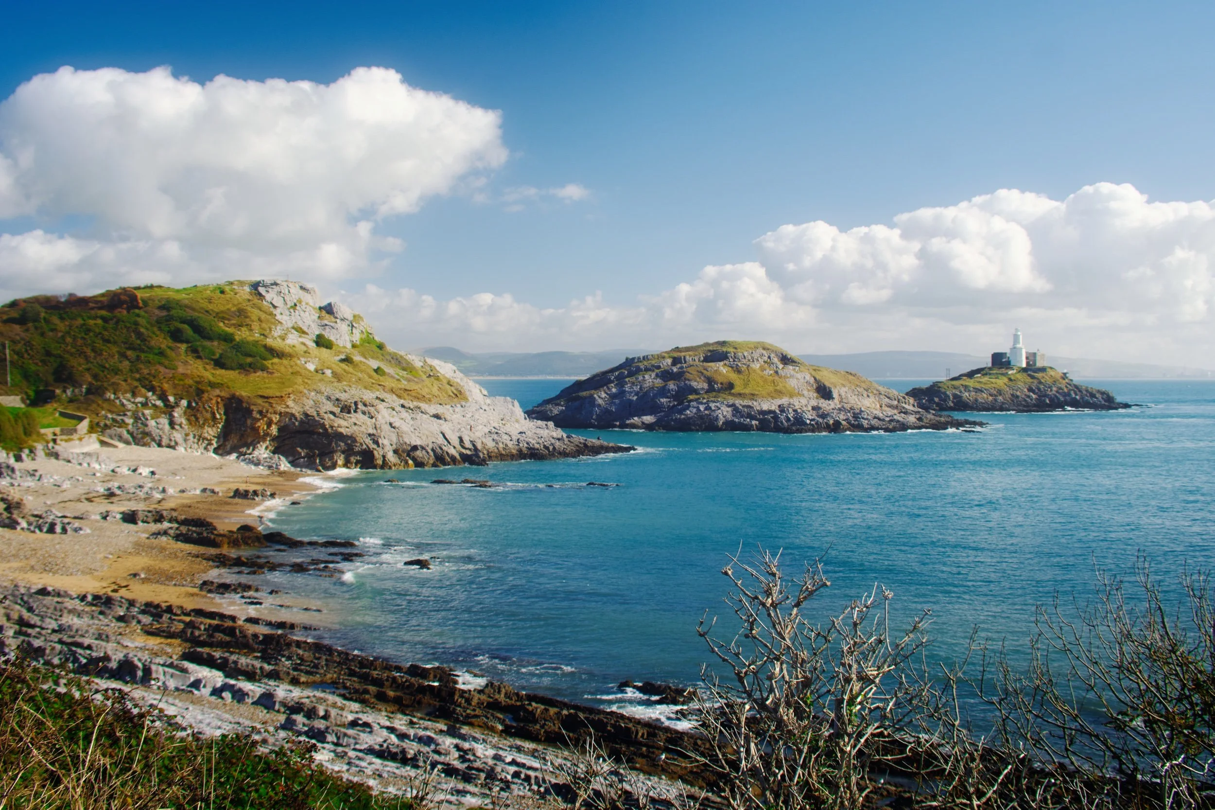
Bracelet Bay, with Mumbles Head to the left, Middle Head dead centre, and Mumbles Lighthouse to the right. You can see why breasts are historically mentioned often in the etymology of Mumbles.
A 9mm ultra-wide composition made from two focus stacked frames of some gorgeous rock samphire with Middle Head and Mumbles Lighthouse in the distance.
Wave-sculpted crags and boulders provided a lovely frame of the Mumbles islands.
I shot a multitude of ultra-wide frames for this composition here, seeking to find the “optimum” way the sea crashed around this sea stack.
We climbed up Mumbles Head for more expansive views of Middle Head, Mumbles Lighthouse, and beyond. Two other guys already there were deep in solemn conversation.
My lovely Lisabet high above the crags of Mumbles Head. Middle Head and Mumbles Lighthouse were starting to catch the sun as it appeared behind the clouds.
An alternative composition as we climbed further up Mumbles Head, with Middle Head attracting the full attention of the sun from behind the clouds.
With the sun dipping behind the clouds again, softer light caressed the shoulders of Mumbles Head and Middle Head. Although breasts are often evoked when viewing these islands, to my mind they’re more like whales of some nature.
Beyond Bracelet Bay we followed the Wales Coast Path west towards Langland Bay. It was turning out to be a corker of a day, the sea glowing a deep aquamarine.
At Rams Tor, looking into the distance at Snaple Point, Whiteshell Point, Pwlldu Head, and Oxwich Point.
Glorious Langland Bay, lined with beach huts and seafront villas. Clearly a popular holiday spot.
The crags of Rothers Torr below the cliffs of Langland Bay.
The Castles of Lllandeilo, South Wales, Autumn
We’re in South Wales for a fortnight!
We’re in South Wales for a fortnight!
It feels great to relax and have a proper break from the severely challenging year we’ve had.
Arriving at our holiday property Friday evening—after a gruelling 5-hour drive in the lashing rain—we woke up Saturday deciding to explore the area nearby where we’re staying around Llandeilo.
Llandeilo is a small town on the western edge of the Brecon Beacons National Park. It’s proper bonny. Evidence of Roman occupation from around 74AD has been discovered here; later on, the settlement was named after a famous Celtic monk—Saint Teilo—with the Welsh word llan meaning a church or monastery, hence the name Llandeilo (pronounced Shan-DAY-loh).
Owing to the long and rich Christian and royal history in the area, there are lots of castles nearby. We explored just two of them: Dinefwr and Castell Carreg Cennen, both impressive in their own right.
After Friday’s insane amount of rain, conditions on the Saturday were thankfully dry and epic.
All photos shot on my Fujifilm X-T2 using my Vivitar “Series 1” 28–105mm f2.8–3.8 zoom and Laowa 9mm f2.8 prime lenses. RAWs converted using Capture One for iPad, developed and finished in Affinity Photo for iPad.
The Castles of Llandeilo, South Wales, Autumn by Ian Cylkowski is licensed under CC BY-NC-SA 4.0![]()
![]()
![]()
![]()
Dinefwr Castle
Below the Dinefwr estate woods, beautiful autumn light and foliage wraps this gorgeous house.
Inside the keep of Dinefwr Castle (pronounced din-EH-vor). The advantage of a 9mm ultra-wide lens is that you’re able to capture a massive field of view in tight compositional situations like this.
Despite being largely built in the 13th century, a lot of the castle is still standing tall and strong.
It’s easy to see why a castle was built here. It’s position on a hill allows for extensive views over the Twyi valley.
It’s possible to climb up the battlements for even more extensive and panoramic views. Autumn colours are just starting to appear in South Wales at the moment.
Up on the highest point of the ruins, looking over the battlements and keep across the Twyi valley on a cloudy and windy day. Truly moody.
The winding stairway leading up is narrow and challenging, especially as the steps themselves are smooth and insubstantial. Amazing how much smaller people were back then.
There’s been a castle at this site since the mid-12th century, but most of present ruins can be attributed to the work of Rhys Gryg in the early 13th century. The castle came into English hands by the end of the 13th century courtesy of King Edward I of England.
By the end of the 15th century the castle came into the hands of Sir Rhys ap Thomas, who began the process of rebuilding and improving the castle. Sir Rhys was a favourite of King Henry VII, largely due to Rhys’ crucial involvement in the Wars of the Roses.
In the distance to the right you can see the turrets of Newton House, built in the 17th century with massive renovations in the 19th century. Around the time of Newton House’s construction, Dinefwr Castle was modified to serve as a summer house.
The castle and its environment were relatively quiet, with most people opting to check out Newton House instead, further to the north. As such, Lisabet and I had ample opportunity to properly explore and photograph the site.
Within the Dinefwr Estate woodland, I spied some gnarly trees covered in moss and quickly sought to make a composition of this gorgeous scene.
The sun appeared from the clouds once again, bathing this house in the woods in autumnal light.
Newton House and its turrets, a wonderful autumnal and historic scene.
Castell Carreg Cennen
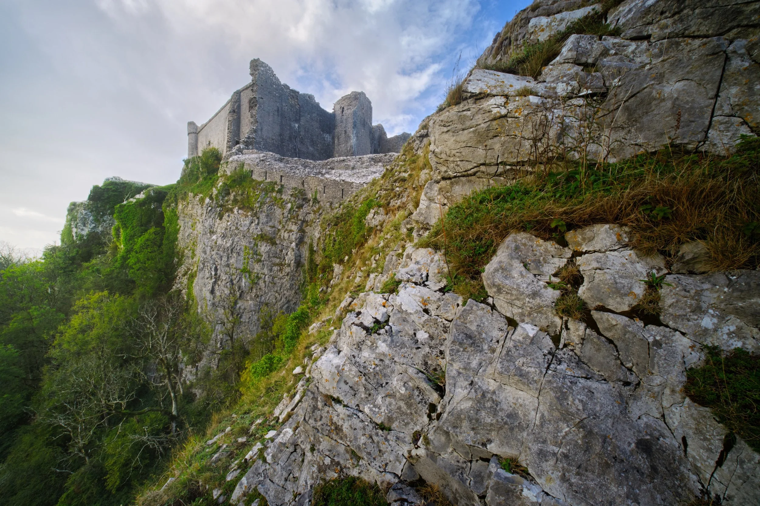
For our second trip for the day, we drove south east of Llandeilo into the Brecon Beacons National Park. Here one can find the impressive ruins of Castle Carreg Cennen, perched atop a high and might limestone crag above the River Cennen.
Rather then head straight into the ruins, Lisabet and I opted to scout around the shoulders of the crag. That’s how we found this ridiculous scene, with the castle perched on the limestone crag and a sheer 300ft drop down.
During our afternoon visit here the weather was much more inconsistent, alternating between brilliant bursts of light and sudden downpours. Whilst I was negotiating my way through the ruins, the sun once again burst through the racing clouds, illuminating this scene.
Castell Carreg Cennen was built in the 12th century, much like Dinefwr Castle, and similarly was claimed by the English through the conquest of King Edward I of England. These days the castle and its land is privately owned by the farm underneath it.
Frankly, one of the most stupendous and visually arresting castles I’ve ever seen.
Back at the farm beneath the castle ruins, a small herd of English Longhorn cows came to graze. Incredible creatures.
A beautiful shaggy coat with those imposing curling horns.
Did you enjoy these photos?

Mallerstang & Smardale, Cumbria, Summer
The British summer heatwave has arrived.
The British summer heatwave has arrived.
I took the opportunity for a long overdue stay over at my Dad’s, so that we could enjoy a lovely wander in the glorious British sunshine during the weekend.
After considering the potential busyness of the Lake District and Yorkshire Dales, we agreed to two outings: the first in the beautiful Mallerstang valley, and the second in Smardale.
Technically Mallerstang falls in the Yorkshire Dales these days, but it is often ignored in favour of some of Dales’ more popular southern hotspots. Smardale, especially Smardale Gill, is a remote and deep valley just outside Kirkby Lonsdale. It features a gorgeous viaduct crossing the valley, the Smardale Gill Viaduct.
In between each excursion, we visited Kirkby Stephen for delicious food.
A crackin’ weekend.
All photos taken on my Fujifilm X-T2 using my Vivitar “Series 1” 28–105mm f2.8–f3.8 zoom and my Laowa 9mm f/2.8 prime. RAWs developed in Capture One for iPad, finished in Affinity Photo.
Mallerstang
Parking up near Aisgill in Mallerstang, I can never ignore this road’s view towards Wild Boar Fell.
Not a bad view if you’re on the Settle–Carlisle line, eh?
Our goal on this hike around Mallerstang was to get onto the Pennine Bridleway and eventually towards the Water Cut sculpture. Along the way, we diverted to get a view of Hell Gill Force, which with the lack of rain looked rather pitiful.
Happy cows staring quizzically at us from across the beck.
A dry Hell Gill Beck reveals the riverbed formations its been carving. Further up the beck as you go up the fellside, the river has cut an impressive gorge that I’d like to explore one day.
Various parts of the Mallerstang valley have been fenced off from livestock, allowing meadows to flourish full of flowers.
Up on the Pennine Bridleway! This is a section of the bridleway known as A Pennine Journey, once walked and described by famed walker Alfred Wainwright.
An oystercatcher (Haematopus ostralegus), unusually high up and inland compared to its preferred breeding grounds near the coast.
As well as oystercatchers, and plenty of sheep, circling above us were Northern Lapwings (Vanellus vanellus), noisily warding us away from their chicks/nest.
Our destination comes into view, and the panorama starts to open up.
This sculpture, found on the Pennine Bridleway, is called “Watercut” by Mary Bourne. The watery gap that divides the sculpture utilises the changing sky to echo the ever-changing flow of water.
It’s hard to resist playing with the cut for photographic compositions.
Across the valley, Wild Boar Fell rises steeply into the sky at 2,323 ft (708 m) high.
The Pennine Bridleway continues down the valley, with Mallerstang Edge above. We elected to trace our footsteps back to the car.
Swarth Fell and the many gills that cut into its fellside.
Smardale Gill
After refuelling with drink and food at Kirkby Stephen, we parked up at Smardale to walk through the nature reserve towards the epic Smardale Gill Viaduct.
Flies followed and pestered us all the way. Nevertheless, Dad managed to spot and nab a superb photo of a toad, and we finally reached the viaduct, granting us views such as this.
Smardale Gill Viaduct was built in 1861, crossing the Pennines to carry coke to the iron and steel furnaces in the Barrow area and West Cumberland. It carried the railway 90 feet (27m) high above the valley and was constructed of locally quarried sandstone. The viaduct has 14 arches of 30 feet span, and a total length of 553 feet (c170m).
High above us, passing clouds created gorgeous gradients of light and shadow across the fellsides.
In the distance is Green Bell, one of the Howgills near Ravenstonedale.
The line was closed in 1962, after British steelmaking finished. For over twenty years the viaduct stood disused, deteriorating from lack of maintenance and exposure to the weather. British Rail wanted to demolish it but instead Eden District Council listed it. In 1989 the Northern Viaduct Trust was setup and in the Autumn of 1992 it was formally handed over to the Trust as a permissible footpath. It has required repair work numerous times since, and still does.
Did you like these photos?
Mallerstang & Smardale, Cumbria, Summer by Ian Cylkowski is licensed under CC BY-NC-SA 4.0![]()
![]()
![]()
![]()
Bowderdale, Howgills, Cumbria, Summer
Today required… flexibility.
Today required… flexibility.
My initial plan for the day was to get up early and head to Kentmere for a lovely walk around the valley and its fells. It’s usually a trial to access Kentmere; the road to it from Staveley is long and narrow with few passing places. Then, once you’re at Kentmere, the only place to park is outside the church, fit for maybe 4–5 cars.
Welp, after an interesting challenge driving the narrow road all the way to Kentmere—dodging and manoeuvring past cars and tractors—I arrived at the church to find it completely full of cars.
At 9 o’clock in the morning on a work day.
So that scuppered those plans. What to do instead? I contemplated trying for Longsleddale instead, but that’s an even longer valley with a narrow one-in-one-out road.
I realised that we’ve reached the time of year where the Lake District is always going to be busy, no matter where you go or when. So instead I navigated back to Kendal and took the A685 towards the Howgills. As I was approaching them, thinking of where to explore, I remembered the Bowderdale valley in the northern Howgills. It’s been a long time since I walked in that valley; time to revisit! In fact, it has been exactly four years to the day since I last explored Bowderdale.
Bowderdale is a long north-to-south valley in the northern part of the Howgills. It’s very quiet compared to the Howgills near Sedbergh. It’s also the source of the River Lune, which winds its way north out of the valley, turns sharply west, then gouges its way south where it has carved out the impressive Lune Gorge that now houses the M6 motorway.
I initially fancied a simple hike down the valley bottom. However, the closer to the valley I got, the more I was attacked by a variety of biting flies and insects. I quickly abandoned this idea and retraced my steps back to where the trail connects with the Dales High Way. This would take me up and over West Fell and I would see what I could see of Bowderdale from above.
Turned out to be a good idea! The weather was glorious.
All photos taken on my Fujifilm X-T2 using my Vivitar “Series 1” 29–105mm f2.8–f3.8 zoom lens. Images made 90% in-camera using the Velvia film simulation, finished off in Affinity Photo.
From my car outside Bowderdale village, the scenery was already looking bucolic.
The country lane to Bowderdale village and ultimately Bowderdale itself. The fell in the distance is West Fell (542 m/1,778 ft), which flanks the western side of the valley.
As I was passing through Bowderdale village I could hear some scuffling on the road behind me. I was being followed by a small flock of sheep! I wonder if they were mistaking me for a local farmer or shepherd?
It felt like I was playing a game of Grandma’s Footsteps/Red Light, Green Light/Statues with the sheep. I would turn to look at them, and they’d stop and suddenly find the grass very interesting.
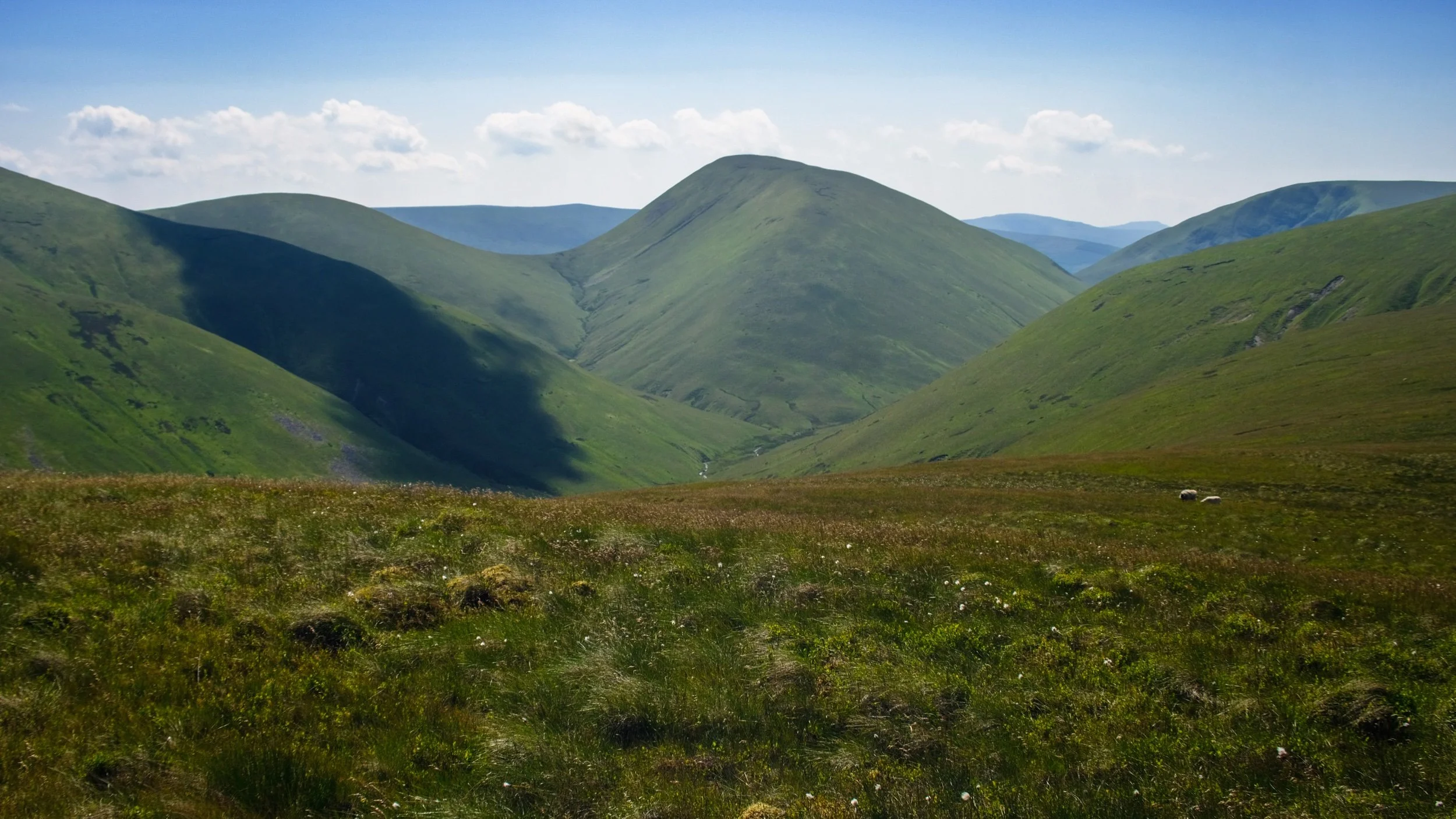
Leaving Bowderdale village, the path climbs up and I catch my first glimpse of Yarlside (639 m/2,096 ft), all the way down Bowderdale.
This was as far as I got on the trail towards the valley bottom, before I was mobbed by biting insects. Time to retrace and look for a different route.
I instead elected for the Dales High Way, which take me up and over West Fell above Bowderdale. Here’s the scene looking back at my progress.
As I near the summit of West Fell, the views west towards Bush Howe above the Langdale valley open up.
On the West Fell ridge, Yarlside comes into view again and the temptation to get a better look proves strong.
Above Yarlside a solitary puffy cloud catches my eye.
Another cloud makes its presence known above Randygill Top.
I neared the eastern edge of West Fell to get a sense of the drop down to Bowderdale.
On the western side of West Fell, East Grain and West Grain join underneath Cobles (534 m/1,751 ft) to become Langdale Beck, which has carved out this beautiful valley.
Looking back north along the shoulder of West Fell to admire the view and track my progress.
It must be noted that this route is probably best tackled in the summer. The trail from the village to West Fell isn’t properly paved, and the fell top shows signs of bogs. This will be a wet and muddy experience in any other season.
Another look west towards Langdale before I crest the summit of West Fell and examine the scene.
The trail drops off West Fell and carries on towards Hazelgill Knott (578 m/1,896 ft) and beyond to the rest of the Howgills. That would be for another day. It was getting awfully hot.
Yarlside in full, which marks the head of Bowderdale. The path at the bottom of Bowderdale skirts around the western flank of Yarlside before dropping down Cautley Spout, one of England’s tallest waterfalls.
I returned to Bowderdale village, and ultimately my car, via the same route, snapping this beautiful bucolic scene.
Bowderdale, Howgills, Cumbria, Summer by Ian Cylkowski is licensed under CC BY-NC-SA 4.0![]()
![]()
![]()
![]()