
Feizor, Yorkshire Dales, Spring
I don’t explore the Yorkshire Dales enough.
I don’t explore the Yorkshire Dales enough.
After finally getting over my post-Skye mourning and depression period, it seemed like spring finally arrived in Northern England.
Aware of how busy the Lake District would be, we instead ventured east to the Yorkshire Dales. We quickly realised that we hadn’t explored the Feizor area of the Dales in a long time, like maybe 7-years or so. Time to fix that.
Feizor (pronounced “FAY-zer”) is a tiny l’al hamlet between Austwick and Settle, and easy to miss. Home to a few houses, a farm, and the famous Elaine’s Tearoom, rising high above the hamlet are the limestone fells of Pott Scar and Smearsett Scar. These were the focus of the day’s hike and exploration.
Pott Scar and Smearsett Scar were beautiful examples of limestone karst landscapes, but they also offered immense views to either the back of Ingleborough or the shapely Pen-y-ghent.
A super day.
All photos taken on my Sony α7ii using my Sony FE 28–70mm f3.5–5.6 OSS and Vivitar “Series 1” 70–210mm f2.8–4.0 zoom lenses. RAWs developed in Lightroom, then tweaked and finalised in Photoshop.
Feizor, Yorkshire Dales, Spring by Ian Cylkowski is licensed under CC BY-NC-SA 4.0![]()
![]()
![]()
![]()
A near-timeless scene in the heart of Feizor. Old stone buildings, dry stone walls, foliage everywhere, and the fells rising up behind.
This quaint scene, complete with old water pump, was something I couldn’t resist making a composition of.
Round the back of Pott Scar, before ascending, one can enjoy expansive views towards Pen-y-ghent, one of the Three Peaks of the Yorkshire Dales.
The squelchy slog up the fell was rewarded with beautiful views from Pott Scar towards Smearsett Scar.
Fin-like clints and grikes of limestone made for a nice leading line towards Smearsett Scar.
Nearer the edge of Pott Scar, I focus stacked these bare limestone edges as they curved off into the distance towards Smearsett Scar.
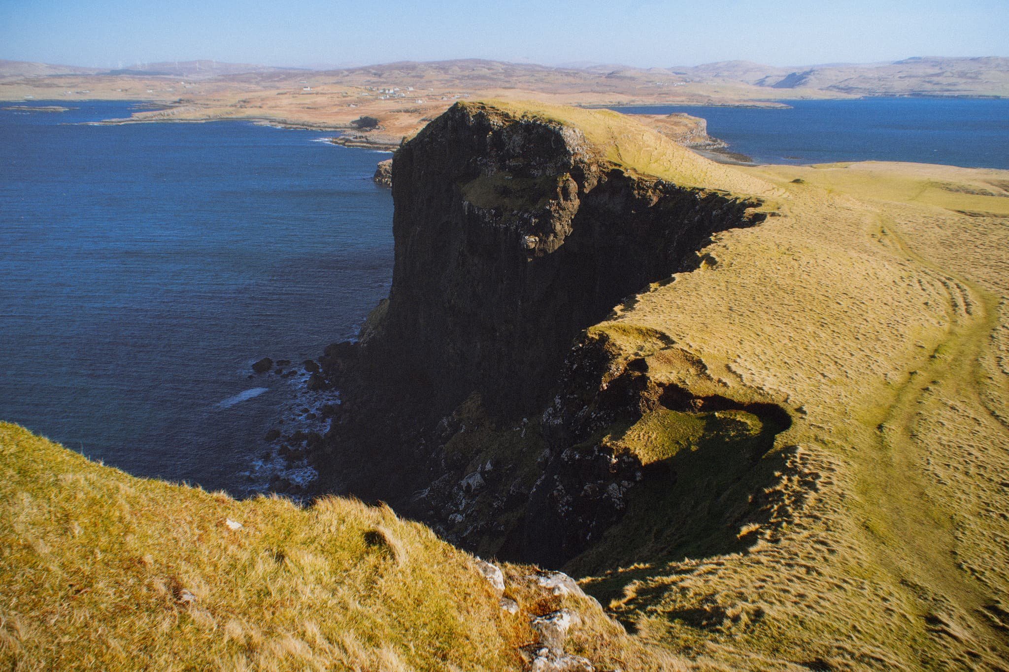
From the summit of Smearsett Scar, the full extent and shape of Pott Scar is revealed. The day was brightening up too, albeit with a haze.
The summit of Smearsett Scar offers a bounty of limestone clints and grikes that I want to make compositions of.
Another variation from the summit of Smearsett Scar, using the exposed clints and grikes as a leading line towards Pott Scar.
Back down the back of Pott Scar, drafting clouds cast dancing shadows across Moughton Scar and the back of mighty Ingleborough, another one of the Three Peaks of the Yorkshire Dales.
Plenty of teeny Swaledale lambs about, hastily retreating back to their mums as we followed the track back to Feizor.
The single road that winds its way through Feizor.
A super-zoomed in composition of the back of Ingleborough, taken from the small lane between Feizor and Buck Haw Brow, light dancing across the karst features of the land.
Did you enjoy these photos?

Trotternish Peninsula, Isle of Skye, Scotland, Spring
The last series of photos from our Skye spring 2024 trip.
The last series of photos from our Skye spring 2024 trip.
There’s a part of me that doesn’t want to post these, because it concludes in a way that we’re no longer on Skye.
And that is always painful.
For this post, I’ve assembled a rag-tag of photos taken from around Skye’s Trotternish peninsula that didn’t really fit in with other posts. This includes:
Duntulm Bay, with the epic ruins of Duntulm Castle perched on top of cliffs of volcanic sill
The ridiculously clear views we got from near the Flodigarry coast, across the sea to the Torridon mountains on the mainland
I hope you enjoy these photo as much as I enjoyed seeing and taking them.
All photos shot on my Sony α7ii using my Pentax SMC 28mm F3.5 prime lens and Vivitar “Series 1” 70–210mm f2.8–4.0 zoom lens. RAWs developed in Lightroom, then edited and finalised in Photoshop.
Trotternish Peninsula, Isle of Skye, Scotland, Spring by Ian Cylkowski is licensed under CC BY-NC-SA 4.0![]()
![]()
![]()
![]()
The epic ruins of Duntulm Castle, perched on top of basalt cliffs nearly 100ft above the surf. Southwest of the ruins, the coast is made of volcanic sill intrusions, criss-crossing joints that make for wonderful compositions.
Further west away from the castle ruins we could even spot across the sea here, known as the Little Minch, the islands of Lewis and Harris. I couple of crystal clear rock pools helped me create some sort of coherent composition from the chaos of rock joints.
Closer to the castle ruins, the sun broke out from the clouds above the Quiraing, giving fantastic side light to this scene. These ridged tufts of grass made for a nice compositional leading line into the scene.
From Flodigarry, above Loch Langaig, a small ruin made for a nice composition, mimicking the shape of the distant mountains.
We were astounded when stopping at Flodigarry to see crystal clear views across the sea towards the Torridon mountains on the mainland. So clear you almost felt you could reach out and touch the mountains.
Further along the mainland, the unmistakable shape of Slioch (“the spear”), above Loch Maree, is immediately apparent, standing 3,219 ft above the sea.
Did you enjoy these photos?
Oronsay, Isle of Skye, Scotland, Spring
We’ve only been to the tiny isle of Oronsay once before.
We’ve only been to the tiny isle of Oronsay once before.
This was back in autumn 2020, before the 2nd pandemic lockdown happened.
Conditions on that occasion were cloudy, flat, and grey. But still, the scenery and views were stunning and we vowed to return again.
And so we did, this time with bright spring skies. A world of difference!
Oronsay can be found in Loch Bracadale, along with lots of other little islands, sandwiched in between the Duirinish and Minginish peninsulas. It’s possible to access Oronsay on foot via a tidal causeway consisting of ankle-breaking fist-sized rocks.
Though only 44 acres in size, it features cliffs 240 ft high, which means it offers incredible views to either the cliffs and hills of the Duirinish peninsula, or the cliffs and Cuillins of the Minginish peninsula.
We didn’t see another soul.
All photos taken on my Sony α7ii using my Pentax SMC 28mm F3.5 prime and Vivitar “Series 1” 70–210mm f2.8–4.0 zoom lenses. RAWs developed in Lightroom using RNI Films’ Kodachrome film profiles, edited and finalised in Photoshop.
Oronsay, Isle of Skye, Scotland, Spring by Ian Cylkowski is licensed under CC BY-NC-SA 4.0![]()
![]()
![]()
![]()
From the mainland at Ullinish it’s a simple, if squelchy, walk from the settlement to the coast. The way to Oronsay then becomes clear; at low tide, the sea is parted by a causeway of boulders and rocks.
Once on the island it’s simple enough to navigate your way towards the highest cliffs. Once there, you get stunning views like this. Zoomed in, the island of Wiay is clear and you can even make out the cliffs and sea stacks of MacLeod’s Maidens.
Looking further east, the eastern end of Wiay gives way to the two distinctive flat-topped hills on the Duirinish peninsula, known as MacLeod’s Tables. The one on the left―MacLeod’s Table South or Healabhal Bheag―is 489 m/1,604 ft. The one on the right―MacLeod’s Table North or Healabhal Mhòr―is 469 m/1,538 ft.
From Oronsay’s tallest cliff, the view northeast down the island and across the loch all the way to Skye proper is just stunning.
Looking back at the tallest cliff, it’s contrasty shape and shadow is used to frame the distant island of Wiay and Duirinish cliffs.
My little Lisabet hiking her way up to the next cliff, whilst I shuffled as close as I dared to the precipitous edge for this monstrous view.
A simple leading line of Oronsay’s cliff edges, all the way back to Ullinish and the moorlands of Skye.
Returning to the lowest part of Oronsay, I venture around its more boggy eastern area for a view back to the craggy cliffs, again using the harsh light and shadow to aid in a leading line composition.
Did you enjoy these photos?

Portree, Isle of Skye, Scotland, Spring
For our 1st full day in Skye, we gradually eased ourselves in.
For our 1st full day in Skye, we gradually eased ourselves in.
Driving 7–8 hours can take it out of you.
So, with pleasing light conditions, we aimed straight for arguably the island’s main settlement, Portree. There’s a fairly well-known hike one can do from Portree, known as the Scorrybreac circuit. You head northeast out of town, take the coastal path below the cliffs of Ben Chracaig, navigate around the corner at Sgeir Mhòe, and follow the coastline towards Toravaig, with magnificent views down the Sound of Raasay and the cliffs of Sìthean a’ Bhealaich Chumhaing. Then it’s a question of hiking up the sharp ascent to Ben Chracaig and onto the path and road back down to Portree.
The views and light around the walk were stunning. Glamaig of the Red Cuillins was coated in snow and clear as a bell.
All photos taken on my Sony α7ii using my Pentax SMC 28mm F3.5 prime lens and Vivitar “Series 1” 70–210mm f2.8–4.0 zoom lens. RAWs developed in Lightroom, then edited and finalised in Photoshop.
Portree, Isle of Skye, Scotland, Spring by Ian Cylkowski is licensed under CC BY-NC-SA 4.0![]()
![]()
![]()
![]()
Upon our arrival at Portree, and parking up at the main car park, the views down Loch Portree towards the snowy Cuillins were already staggering. I quickly attached my longest lens and went snappy happy as the lighshow was constantly changing.
Our goal was to follow the coastal path below the left hill. But before we could get on that, this scene opened in front of me, putting me in mind of the fjords of Norway. I zoomed all the way to 210mm to get a real tight composition, involving the flanks of Ben Chracaig to the left, the crags of Ben Tianavaig to the right, and the hills of the Isle of Raasay in the middle.
On the trail, the sound of rushing water caught our attention. We quickly nipped off trail and followed the sound, locating this beautiful and totally unexpected waterfall! These unnamed falls belong to the River Chracaig as it tumbles down the hills above.
As we rounded the corner at Sgeir Mhòr, this magnificent view down the coastline to the illuminated cliffs of Sìthean a’ Bhealaich Chumhaing appeared.
We followed the trail further down the coastline until it abruptly turns inland near this area of flat land. The path then zigzags up the steep hillside of Ben Chracaig. Halfway up, lighting conditions changed and I quickly nabbed this dramatic shot.
Away from the cliffs and onto the moorland above Portree, this frankly ridiculous scene revealed itself to us. The Storr, lightly dusted in snow, with a thick and dramatic storm above, whilst the Portree moorlands and this house receive a strong burst of sunlight from behind us.
Back at Portree the light continued to change dramatically, with the clouds lifting above the Cuillins. I zoom in tight on this composition of Portree harbour as the light broke through the clouds enough to highlight the snowy Cuillins.
Did you enjoy these photos?

Sleat Peninsula, Isle of Skye, Scotland, Spring
Skye’s Sleat peninsula often gets overlooked.
Skye’s Sleat peninsula often gets overlooked.
It’s understandable why. When the island contains wonders such as the Cuillins, the Quiraing, the Storr, the Fairy Pools and more, why would you go to the extreme south/south-west of the island?
In my experience, Sleat is where you take photos from, not of. While the peninsula does have some lovely coastline, arguably it’s finest aspect is the views you can get from its southern and northern shores.
Looking south across the Sound of Sleat one can enjoy immense views of the Knoydart mountains, such as Ladhar Bheinn, Meall Buidhe, and Luinne Bheinn.
Over the peninsula onto its northern shores, Sleat harbours beautiful beaches and craggy coastlines, punctuated by bonny little crofting settlements, such as Tarskavaig, Tokavaig, and Ord. These places get unparalleled views across Loch Eishort towards the entire Cuillins range.
My advice: Give yourself a day to explore Sleat. You won’t regret it.
All photos taken on my Sony α7ii using my Rokinon 14mm f2.8 ED AS IF UMC and Pentax SMC 28mm F3.5 prime lenses, and my Vivitar “Series 1” 70–210mm f2.8–4.0 zoom lens. RAWs developed in Lightroom then edited and finalised in Photoshop.
Sleat Peninsula, Isle of Skye, Scotland Spring by Ian Cylkowski is licensed under CC BY-NC-SA 4.0![]()
![]()
![]()
![]()
Just north of Armadale there’s a stretch of coastline known as Bàgh a' Mhuilinn (“Bay of the Mill”). Here, one can play around with incredible rock formations and the Knoydart mountains in the distance.
The geology around Armadale is largely comprised of Lewisian Gneiss, which are some of the oldest rocks on Earth; roughly 3.0–1.7 billion years old! In the distance the main peak in the Knoydart is Ladhar Bheinn (“peak of the hoof”).
From near Armadale you can take the single-track winding road over the Sleat peninsula towards its northern shores. Along the way, though, magnificent views of the Cuillins reveal themselves. We stopped to nab some photos from above Loch Dhùghaill because who can say no to this?!
Arriving at Tarskavaig Bay, Lisabet and I quickly wandered off to explore and photography. I found this fascinating person-high crag on the beach, and clambered within its nooks and crannies looking for compositions. These are Lewisian Gneiss again, but have been squashed and stretched so much that they've become very fine-grained and have lots of cracks. They also have minerals like chlorite and epidote in them.
Away from the massive crag I head towards the more expansive beach, with fantastic clear views towards the Cuillins. I find another otherworldly rock formation and seek to compose along with the winding channels towards the Cuillins.
Moving on from Tarskavaig, we continue up the northern shore of Sleat to Tokavaig. At Tokavaig Bay, one can find the ruins of Dùn Scaich castle, formerly owned by Clan MacDonald of Sleat, a branch of the Clan Donald or MacDonald. With my long zoom lens, I can really compress the distant views, capturing the ruins of the castle as well as the mighty Blàbheinn mountain in the distance.
Dùn Scaich castle sits atop a crag on the Tokavaig coast, given near 360 views of its surroundings. It would’ve once been possible to enter the ruins across the arched footpath, but the floor of it has collapsed. The fortress is alternatively referred to as the "Fortress of Shadows." It is famously associated with the legend of the warrior woman Scáthach, who is said to have resided there, giving the castle its name.
Further long the coastline from the castle ruins are several sheer cliffs that offer unimpeded views across Loch Eishort to the entire Cuillins range. Here, my Lisabet stands perilously close to the edge of one cliff, providing a sense of scale.
The view you can enjoy from Tokavaig’s cliffs. The small trio of islands in the loch are called Eilean Ruairidh, translating as “Isle of the Red King”. There was once a fort here too. From this view, it’s clear to view the geological differences between the Black Cuillins, towards the left, and the Red Cuillins towards the right. The Red being smoother and made of granite, and the Black being more jagged and made of gabbro.
Further along the coastline we arrive at Ord, where one can take the minor road back over the Sleat peninsula to its southern shores. Before we did, we explored the bay here too. At Ord, you can find crags on the beach where old rocks meet some younger rocks called quartzites, and the younger rocks are found underneath the older ones, which is a bit unusual. The quartzites have some cool features, like cross-bedding (patterns in the rock) and folding (where the rock has been bent).
From Ord I once again equipped my 70-210mm zoom lens for some tighter compressed compositions. I lined up the small rocky islands just off the bay to lead towards the Strathaird coastline and Blàbheinn looming above everything.
Did you enjoy these photos?

Under Loughrigg, Lake District, Winter
A brief respite amongst all the rain.
A brief respite amongst all the rain.
Despite the weather, this week has been as busy as ever. A large part of that is simply that it’s half-term for schools. Still, we figured people would be starting to head back home, so the Lake District wouldn’t be as busy.
Nope.
Our planned circuit of Grasmere was foiled due to every car park being full. Every. One.
So, change of plan. We managed to park further towards Ambleside, right next to the cricket ground, and instead do a small circuit around the Under Loughrigg area in between Ambleside and Rydal.
Still proper bonny. And, happily, signs of spring are starting to appear.
All photos taken on my Sony α7ii using my Pentax SMC 28mm F3.5 and Pentax SMC 55mm f2.0 prime lenses, plus Vivitar “Series 1” 70–210mm f2.8–4.0 zoom lens. RAWs developed in Lightroom, edited and finalised in Photoshop.
Under Loughrigg, Lake District, Winter by Ian Cylkowski is licensed under CC BY-NC-SA 4.0![]()
![]()
![]()
![]()
On the A591 between Ambleside and Rydal, one can enjoy formidable views towards Nab Scar (455 m/1,493 ft).
The flat pasture land in between Loughrigg Fell and the A591 allows for extensive views across to the surrounding fells. There were also plenty of signs of storm damage, with fallen trees and split trunks everywhere. In this case, it allowed for a nice composition towards a highlighted Low Pike (508 m/1,667 ft).
I cropped in tightly for this composition at 210mm to grab these Swaledale ewes milling around a beautiful crag, and subtle hints of the wall of Nab Scar in the background.
A surviving Scots Pine makes for a dramatic composition with the Kirkstone fells in dark shadow behind.
One of the Lake District’s well-known views, often causing sudden brakes by drivers on the A591. Looking towards Rydal, with the Kirkstone fells catching a sweeping lightbeam.