Grassington, Yorkshire Dales, Autumn
Autumn is coming.
Autumn is coming.
Knowing that yet more rain was on its way in the afternoon, and that our best chances were further east, we elected to head into the Yorkshire Dales. Here we embarked on a nice 10 km hike, taking in the epic Linton Falls, timeless Grassington, and Grass Wood Nature Reserve.
While there were certainly hints of autumn colours, it seems we need another couple of weeks around our latitude before they reach peak conditions. That’s assuming, of course, that the weather cooperates and doesn’t just blow all the leaves straight off the trees.
Although strictly speaking a town, Grassington has a wonderfully timeless Yorkshire village vibe. As a result, it was selected as the primary location for the 2020 reboot of All Creatures Great and Small, playing the role of the fictional Yorkshire town of Darrowby.
All photos shot on my Sony α7ii using my Sony FE 28–70mm f3.5–5.6 OSS zoom lens. RAWs were largely developed using Capture One for iPad, and finalised using Lightroom for iPad and Darkroom for iPad.
Grassington, Yorkshire Dales, Autumn by Ian Cylkowski is licensed under CC BY-NC-SA 4.0![]()
![]()
![]()
![]()
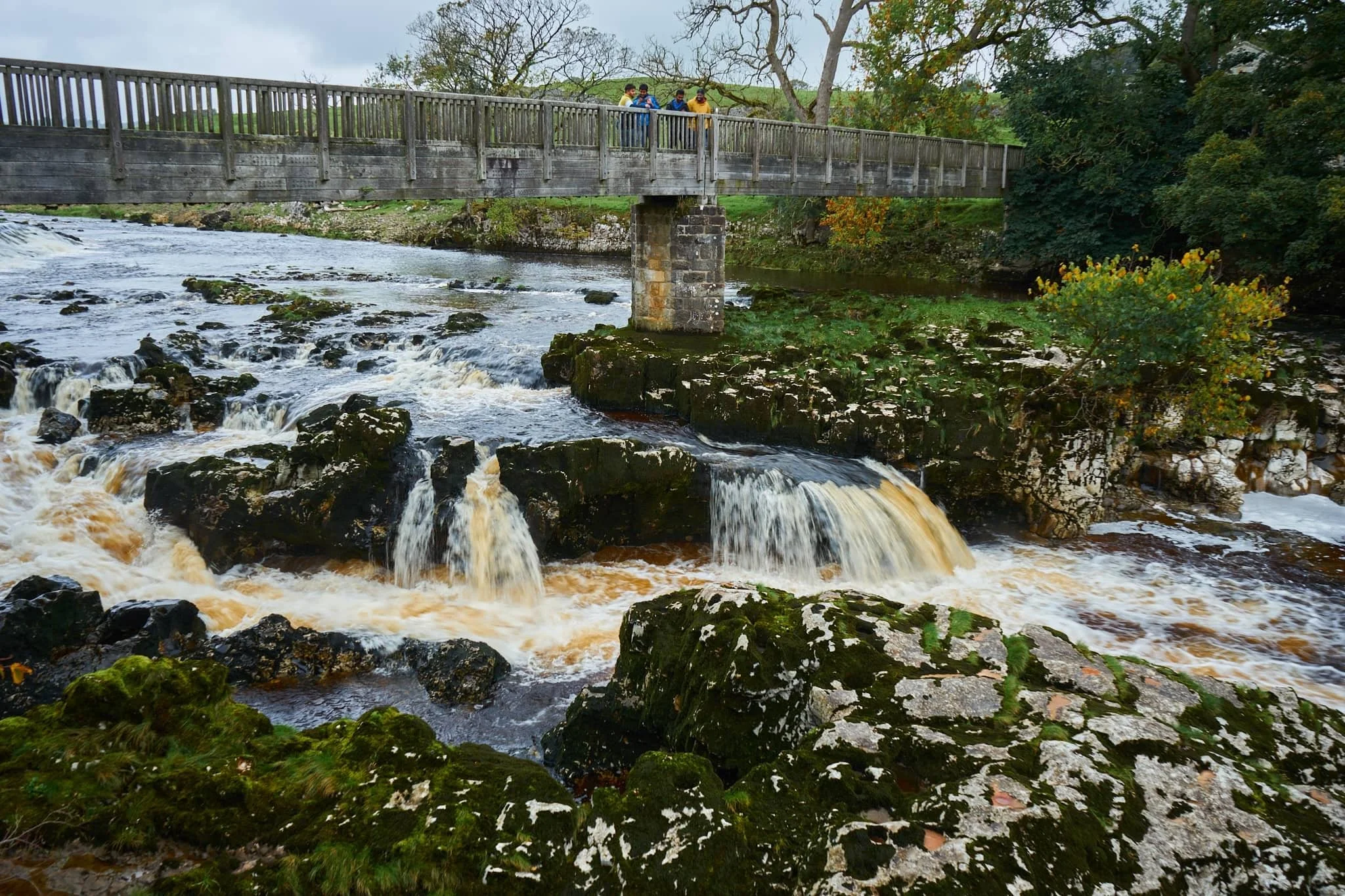
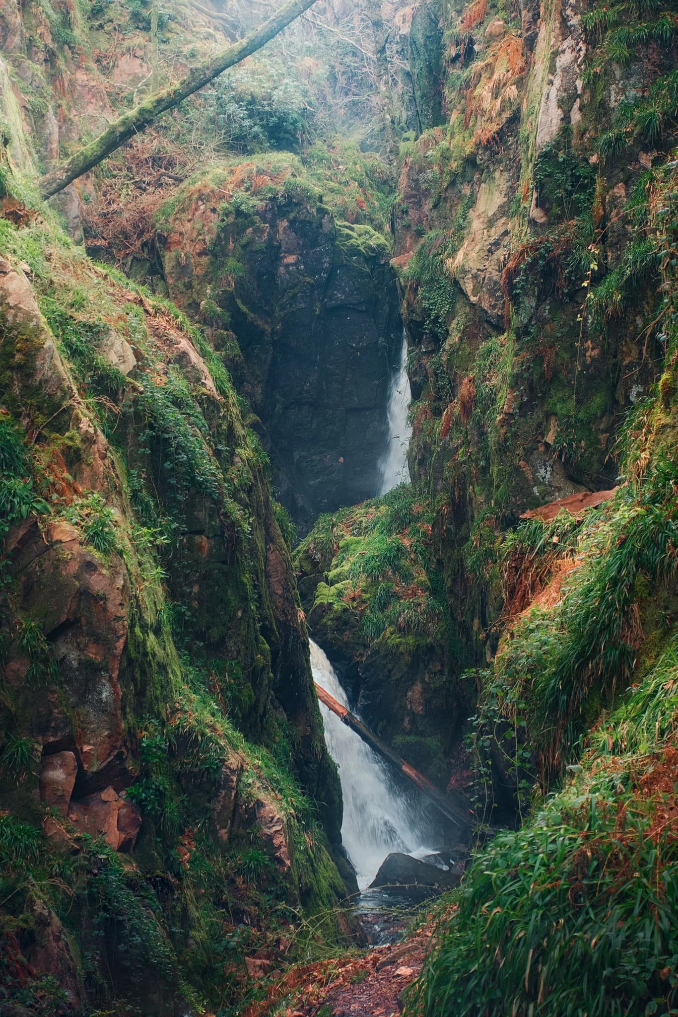
Linton Falls, a series of powerful cascades crashing over a limestone fault in the River Wharfe.
Just above the falls are a couple of weirs that sweep across the river, disrupting the flow of water so as not to sweep away at the river bank so much.

My Lisabet on the footbridge above the thundering falls. It’s quite the drop and a somewhat unnerving sensation.
From the footbridge looking down, it’s easy to make out the fault. Here, a prehistoric seismic shift in the earth will have uplifted some of the limestone in the river bed higher than the rest, creating these cascades and limestone platforms.
Looking upstream, you can make out the second weir and Linton Falls Hydro. There’s been a hydroelectric power station here since 1909, but was closed down in 1948. Decades later, in 2012, the building came back into use once again as a hydroelectric generating power station, modified to minimise harm on nature and local wildlife.
Beyond the footbridge we took the ancient Sedber Lane up the fellside towards Grassington. Looking back down offers an enchanting, if moody, Yorkshire Dales scene.
Grassington. Mentioned in the Domesday Book of 1086 CE, the village was originally documented as Gherinstone, Garsington, or Gersington. The name is a mix of Old Norse and Old English, meaning either “the town of the grassy ings” or a “farmstead surrounded by grass.”
Stopping for some coffee and cake, we then wandered gently around the village documenting some of the more timeless scenes Grassington had to offer (save, of course, for all the vehicles unceremoniously dumped everywhere).
A lot of old architecture in Grassington has survived remarkably well, aiding the village’s “ye olde worlde” appeal.
Bunting zigzagged across the skyline above us as we made our way up the higher parts of Grassington.
The Black Horse Hotel. Originally built in the 17th century as a coaching inn, it saw additions and alterations in the 18th and 19th centuries.
Above the Black Horse Hotel, we continued up Garrs Lane. Save for the road markings, you could easily transport your mind back several centuries, looking at this scene.
A beautiful cottage with window shutters. To the right an old resident had just finished tending to a beautiful garden.
Right near the junction of Main Street, Garrs Lane, and Moor Lane, this wonderful shop—Ashton House Crafts & Carving—was busy displaying all its various sculptures, carvings, and wood chimes. Just delightful.
Chamber End Fold has maintained its cobbled street, helping to cement this ageless Yorkshire scene (if we carefully ignore the car).
We continued up north out of Grassington, taking the ancient Bank Lane onto the Dales High Way and west towards Grass Wood Nature Reserve. Old stone barns decorate the way towards the woods.
These little pops of autumn hues were a tantalising prospect of what is to come.
Grass Wood Nature Reserve is one of the largest broadleaved woodlands in the Dales, comprised primarily of ash woodland interspersed with limestone scars. We followed the minor trail alongside Gregory Scar, thick in the woods.
A delicate little scene, showing the beginnings of those beautiful autumnal colours.
Nearing the exit, this part of the woods was carpeted in fallen autumnal foliage.
Nearing Grassington via Grass Wood Lane, one final composition arrested my attention near the cricket grounds.
Did you enjoy these photos?
Colwith Force, Lake District, Autumn
The last of the summer holidays.
The last of the summer holidays.
After a lovely Friday evening in Dentdale, and a glorious Saturday in Kingsdale, we returned to the Lake District on Sunday for a hike to Colwith Force and back.
The weekend saw the advent of a heatwave settling over the British Isles. To counter, we head to Skelwith Bridge early in the morning for cooler conditions and before the majority of summer holidayers were about.
We were rewarded with beautifully moody, misty conditions to start, then as the temperatures rose the mist burned off, swirling around the fell tops and creating dramatic scenery. Just perfection.
All photos taken on my Sony α7ii using my Sony FE 28–70mm f3.5–5.6 OSS zoom and Rokinon 14mm f2.8 ED AS IF UMC ultra-wide prime lenses. RAWs developed in Lightroom using RNI Films’ Kodachrome film profiles, finalised in Photoshop.
Colwith Force, Lake District, Autumn by Ian Cylkowski is licensed under CC BY-NC-SA 4.0![]()
![]()
![]()
![]()
Typically, we start the walk to Colwith Force from Skelwith Bridge. From here we cross the River Brathay and head west. But before crossing the river, we can never resist getting up close and personal with the beautiful Skelwith Force.
Looking upstream from Skelwith Force. You can just about make out the bridge that takes you across the river.
Up and out of the woods around Skelwith Force, we head west where the views started to open up. Well, to a degree. Early morning fog clung to the fell tops, making for moody images.
Looking back down the route we came up. You can just about make out the knuckly profile of Loughrigg but nothing beyond.
After navigating a series of narrow footpaths punctuated with tight kissing gates and stiles, the trail starts to head back down Little Langdale. But before we do, this magnificent composition demands your attention: Wetherlam (763 m/2,502 ft) fighting the swirling mist as the morning sun burns it all off.
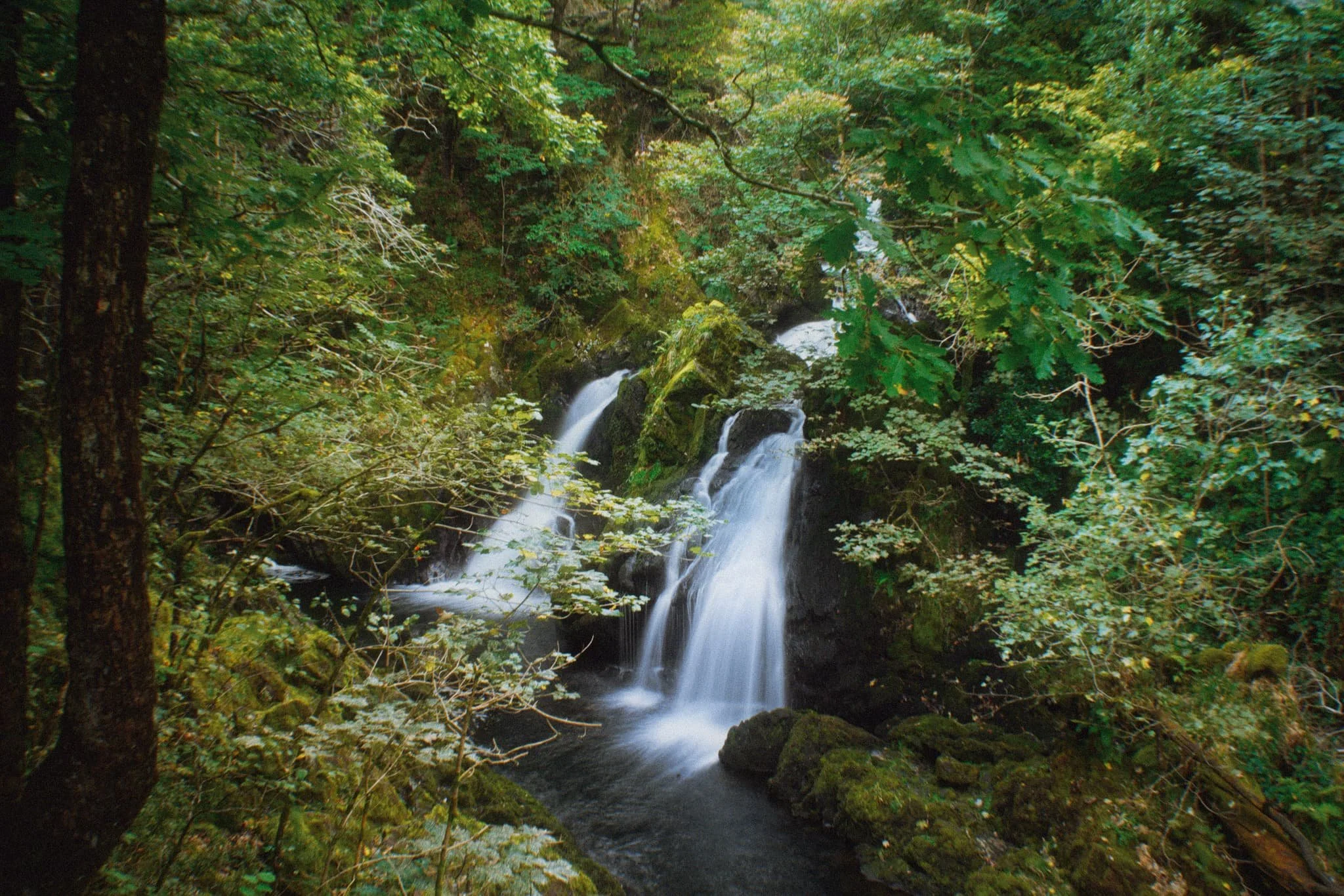
Down at the valley bottom we entered Tongue Intake Plantation and picked our way up through the woods to find our main goal for the day: Colwith Force, a double spout waterfall. Evidence of the approach of autumn is all around us.
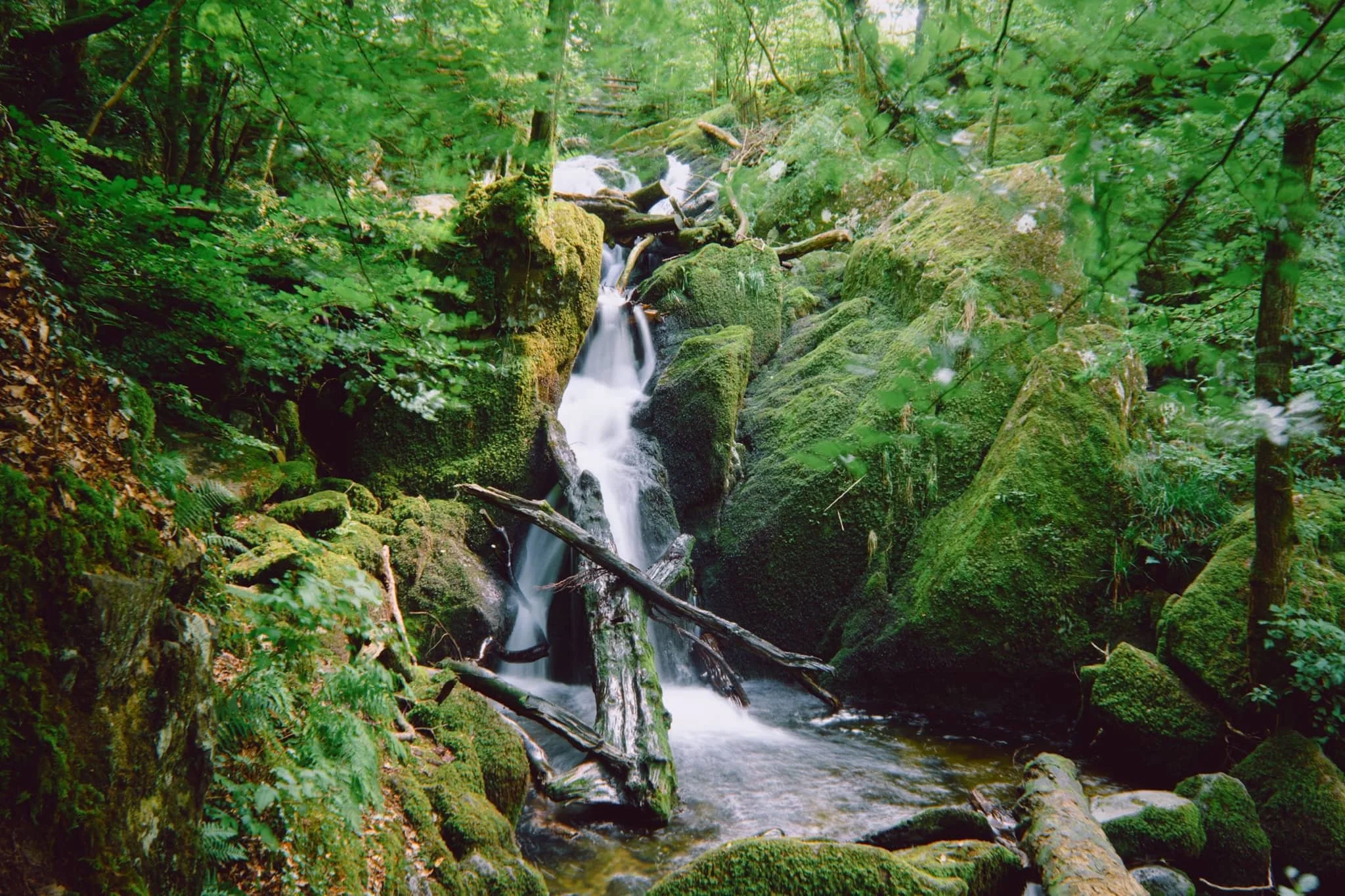
Some people simply turn around and head back, but we’re fans of following the trail as it ascends up and above the waterfall. From above it, interesting compositions can be found of all the falls before the main double spout.
Though a little dry this time, there’s a lovely series of falls above Colwith Force that deserve attention.
Beyond the upper falls we followed the circular trail back out of the plantation and sought the Little Langdale road back towards Skelwith Bridge. Emerging from the woods, the fells were now clear of the morning mist, revealing their autumnal coats.
Just goes to show the massive difference a change of light conditions can do to the mood and feel of a photograph. Loughrigg and the Grasmere fells beyond, now clearly visible.
Herdwick yows (ewes) and their lambs peacefully graze in the now gorgeous autumnal morning sun. A timeless scene.
Nearing Skelwith Bridge, we could finally see the Langdale Pikes after being consumed by the fog all morning.
Did you enjoy these photos?
Stockghyll, Lake District, Summer
Lots of rain means one thing: waterfalls.
Loads of rain means one thing: waterfalls.
Though certainly not as numerous or epic as in the Yorkshire Dales, the Lake District is still home to some lovely waterfalls.
Certainly one of the more accessible, yet grand, waterfalls is Stockghyll Force in Ambleside. We last hiked around here in June 2020, just as the UK’s COVID-19 lockdown was starting to ease off. Ambleside, usually one of the busiest honeypots in all the Lake District, was eerily quiet on that visit.
Things were very much back to normal this time. Lots of people about, sipping pints in pubs, chatting over coffee and cake with friends, and hiking in and around the town.
And all the rain we’ve had in July has meant that Stockghyll Force should be in full flow. Boy did she look good.
All photos taken on my Sony α7ii using my Sony FE 28–70mm f3.5–5.6 OSS zoom lens. RAW files were corrected in Lightroom, developed using RNI Films’ Kodachrome film profiles, and finalised again in Lightroom.
Stockghyll Force, Lake District, Summer by Ian Cylkowski is licensed under CC BY-NC-SA 4.0![]()
![]()
![]()
![]()
From the car park opposite the Log House, we elected for the back roads towards the waterfall, rather than trekking alongside the main road. It gave us lovely, almost timeless, scenes like this.
Soon enough we exited the town centre, hiked up the road alongside the beck, and head into the woodland surrounding the waterfall. A lovely little weir, bathed in sunlight, made for a nice composition.
Further into the woods, a small beck flows underneath this delightful little bridge.
At the main waterfall itself, I perched myself and the tripod gingerly on a crag above the main drop, seeking a composition looking all the way down the falls to the gorge below.
The upper part of Stockghyll Force, surrounded by jagged, mossy crags and lush verdant vegetation everywhere.
After leaving one side of the trail, we took a lunch break at a new cafe that’s recently opened not 30 m away from the waterfall. Force Cafe. Delicious food and drink, and absolutely stunning views from their open terrace.
Heading back down the other side of the trail, the classic view of Stockghyll Force emerges and I cannot resist.
However, just a little further down the trail, I think the best view of Stockghyll Force can be obtained.
Did you enjoy these photos?
Aber Falls, Snowdonia, Spring
Much like South Wales, North Wales and Snowdonia has its fair share of waterfalls.
Much like South Wales, North Wales and Snowdonia has its fair share of waterfalls.
One such waterfall we’ve never visited before, and was relatively close to where we’re staying for the week, is Aber Falls, just south of the village of Abergwyngregyn.
For most people, this involves a very simple walk from the Nature Reserve car park to the falls. But there is a second waterfall, less visited, that we decided to check out too.
The late afternoon/early evening gave us glorious light to work with, and the scale of the waterfalls were a sight to behold.
Photos taken on my Sony a7ii using a Vivitar “Series 1” 28–105mm f2.8–3.8 zoom and Rokinon 14mm f2.8 prime lenses. RAWs developed in Capture One for iPad, then edited and finalised in Affinity Photo 2 for iPad.
The falls are very popular. Accompanying us on the walk to Aber Falls were a large group of overseas students enjoying the delights of Wales. The falls can be seen from miles away.
We made it to Aber Falls in no time and began scrambling around the boulders, seeking compositions of this 120ft waterfall plunging into its pool.
Of course, we weren’t the only ones at the falls, so patience was required to shoot photos when people left the frame. Additionally, I shot many exposures to really push the limits of how slow I could get the shutter speed whilst handheld. The Sony a7ii served me well.
Further along the head of the valley one can find another, less-visited, waterfall. This is Rhaeadr-bach or Rhaeadr Fach, which essentially means “smaller waterfall”, with Aber Falls technically named Rhaeadr-fawr, or “bigger waterfall”. This smaller waterfall had hollowed out a perfect little raised pool before dropping further into the river.
Did you enjoy these photos?

Stanley Ghyll Force, Lake District, Spring
After a sobering return from a beautiful week in the Highlands, it was time for a beautiful little jaunt in Eskdale.
After a sobering return from a beautiful week in the Highlands, it was time for a beautiful little jaunt in Eskdale.
I was also due to hang out with me Dad again. After arriving at Dad’s, he suggested checking out Stanley Ghyll Force, one of the Lake District’s largest waterfalls. I were game for that!
Stanley Ghyll Force is located in Eskdale, a gorgeous valley in the southwestern corner of the Lake District. The last―and only―time I visited Stanley Ghyll Force was back in 2017. I know this because I shot the waterfall with a Sigma dp0.
Back then, I was all on me own attempting to navigate a tricky gorge. However, on that occasion, I was able to get right to the bottom of the falls for some cracking.
A lot has changed in the intervening 5-6 years. For a start, you can’t get to the bottom of the falls anymore. The path has eroded and collapsed to the point that it’s too dangerous. Instead, the Lake District National Park have created an alternative route that scales up the sides of the gorge so that you can get above the falls. In addition, they’ve also cut back hectares of invasive rhododendron and constructed a fantastic viewing station above the gorge.
We enjoyed some fantastic light, and I had a grand day out with me Dad.
All photos taken on my Fujifilm X-T2 using my Vivitar “Series 1” 28‒105mm f2.8‒3.8 zoom, Super Ozeck 80mm‒210mm f4.5 zoom, and Laowa 9mm f2.8 ultra-wide prime lenses. RAWs developed in Capture One for iPad, edited in Affinity Photo 2 for iPad.
Stanley Ghyll Force, Lake District, Spring by Ian Cylkowski is licensed under CC BY-NC-SA 4.0![]()
![]()
![]()
![]()
The gorge that contains Stanley Ghyll Force is wonderfully mossy and vibrant. Here, a pocket of light illuminates a boulder field exposed in the woodland.
We passed a small tributary beck that was catching some wonderful light in the gorge.
Eventually, the glory of Stanley Ghyll Force came into view. This was as close as we were allowed to get to it. Still some absolutely crackin’ light flooding into the gorge though.
After hiking up the new path made by the National Park, we found the new viewing station to check out the views it offered. And… wow. A sheer 150ft drop pulls your down the gorge and towards Stanley Ghyll Force. What a sight.
We followed the return track back down to the valley. As we did, me and Dad spotted some incredible light playing out on the distant Eskdale fells, and stopped to shoot photos like crazy.
Did you like these photos?

Kinlochleven, Lochaber, Scotland, Winter
Where to go on the final day of our week long Scottish Highlands getaway?
Where to go on the final day of our week long Scottish Highlands getaway?
We had a few options, but ultimately settled on an area we’d only visited once, the very first time we explored Glencoe in Autumn 2014: Kinlochleven.
Kinlochleven is a small village situated at the eastern end of Loch Leven and completely surrounded by massive mountains. The Loch Leven valley feels more like a Norwegian fjord; a small ribbon lake with mountains rising sheer from the water.
Last time we visited, we barely scratched the service of what there was to offer, largely because of how unfit I was. That situation is a bit different these days, so we embarked on a more more strenuous and adventurous hike.
It were glorious. A great day to end the week.
All photos taken on my Fujifilm X-T2 using my Vivitar “Series 1” 28–105mm f2.8–3.8 zoom lenses. RAWs converted in Capture One for iPad, developed using RNI Films’ Kodachrome film profiles, finalised in Affinity Photo 2 for iPad.
Kinlochleven, Lochaber, Scotland, Winter by Ian Cylkowski is licensed under CC BY-NC-SA 4.0![]()
![]()
![]()
![]()
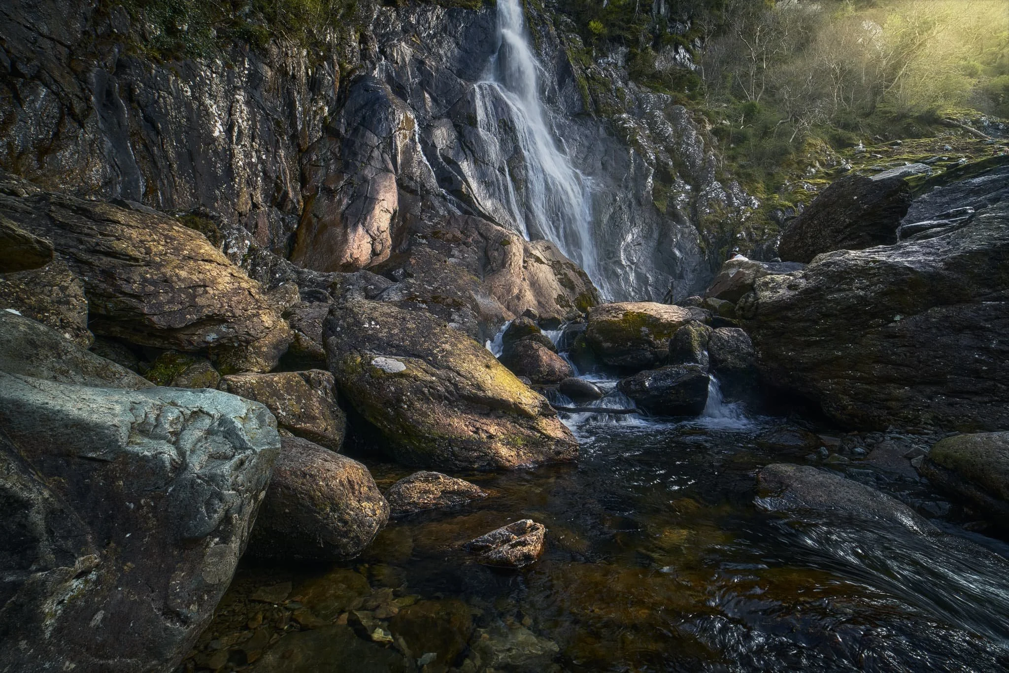
One aspect of the Kinlochleven area we completely missed all those years ago was a large and very accessible waterfall. So this was the first thing to tick off the list. This is Grey Mare’s Tail, which plunges nearly 50m in a single drop. This scene, with a tiny Lisabet gazing upon the falls, put me in mind of some of the photographs I’ve seen of some of the Yosemite waterfalls.
After gingerly picking our way around the falls, it was time to begin the steep ascent up the flanks of Leachd na h-Aire to seek views of the loch and the mountains above it. It didn’t take long before we could see the magnificent shape of the Pap of Glencoe above the loch like a wizard’s hat.
Zooming in for a tighter composition of the Pap, using some of these lovely Scottish pines to the frame the scene.
After a slight wrong turn we used this deviation to our advantage by climbing up onto a small knoll that offered this spectacularly clear view of Loch Leven and her mountains. What a sight. The Pap of Glencoe to the left, and Beinn na Caillich on the right.
A small cluster of Scots pines provide a nice compositional aid, pointing upwards to the magnificent Pap of Glencoe. As the day went on, the light got better and better.
Our goal was to locate the now abandoned Mamore Lodge hotel, which has apparently been left to rot for a decade or so now. Along the way, I snapped one more composition of the Pap.
We finally arrived at the former hotel, and scanned around its perimeter. The lodge was originally built in 1903 for Capt. Frank Bibby, who made his fortune in the Liverpool shipping industry. The aluminium works company, whom essentially created the village Kinlochleven, apparently built the lodge in return for the grant of additional land to house workers back down in the village. Sad to see this.
From the abandoned Mamore Lodge, we were able to locate the small road and follow it all the way back down to the loch, happily snapping compositions along the way.
Beinn na Caillich catching some golden wintersun as we followed the winding road down to the loch shore.