
Sleat Peninsula, Isle of Skye, Scotland, Spring
Skye’s Sleat peninsula often gets overlooked.
Skye’s Sleat peninsula often gets overlooked.
It’s understandable why. When the island contains wonders such as the Cuillins, the Quiraing, the Storr, the Fairy Pools and more, why would you go to the extreme south/south-west of the island?
In my experience, Sleat is where you take photos from, not of. While the peninsula does have some lovely coastline, arguably it’s finest aspect is the views you can get from its southern and northern shores.
Looking south across the Sound of Sleat one can enjoy immense views of the Knoydart mountains, such as Ladhar Bheinn, Meall Buidhe, and Luinne Bheinn.
Over the peninsula onto its northern shores, Sleat harbours beautiful beaches and craggy coastlines, punctuated by bonny little crofting settlements, such as Tarskavaig, Tokavaig, and Ord. These places get unparalleled views across Loch Eishort towards the entire Cuillins range.
My advice: Give yourself a day to explore Sleat. You won’t regret it.
All photos taken on my Sony α7ii using my Rokinon 14mm f2.8 ED AS IF UMC and Pentax SMC 28mm F3.5 prime lenses, and my Vivitar “Series 1” 70–210mm f2.8–4.0 zoom lens. RAWs developed in Lightroom then edited and finalised in Photoshop.
Sleat Peninsula, Isle of Skye, Scotland Spring by Ian Cylkowski is licensed under CC BY-NC-SA 4.0![]()
![]()
![]()
![]()
Just north of Armadale there’s a stretch of coastline known as Bàgh a' Mhuilinn (“Bay of the Mill”). Here, one can play around with incredible rock formations and the Knoydart mountains in the distance.
The geology around Armadale is largely comprised of Lewisian Gneiss, which are some of the oldest rocks on Earth; roughly 3.0–1.7 billion years old! In the distance the main peak in the Knoydart is Ladhar Bheinn (“peak of the hoof”).
From near Armadale you can take the single-track winding road over the Sleat peninsula towards its northern shores. Along the way, though, magnificent views of the Cuillins reveal themselves. We stopped to nab some photos from above Loch Dhùghaill because who can say no to this?!
Arriving at Tarskavaig Bay, Lisabet and I quickly wandered off to explore and photography. I found this fascinating person-high crag on the beach, and clambered within its nooks and crannies looking for compositions. These are Lewisian Gneiss again, but have been squashed and stretched so much that they've become very fine-grained and have lots of cracks. They also have minerals like chlorite and epidote in them.
Away from the massive crag I head towards the more expansive beach, with fantastic clear views towards the Cuillins. I find another otherworldly rock formation and seek to compose along with the winding channels towards the Cuillins.
Moving on from Tarskavaig, we continue up the northern shore of Sleat to Tokavaig. At Tokavaig Bay, one can find the ruins of Dùn Scaich castle, formerly owned by Clan MacDonald of Sleat, a branch of the Clan Donald or MacDonald. With my long zoom lens, I can really compress the distant views, capturing the ruins of the castle as well as the mighty Blàbheinn mountain in the distance.
Dùn Scaich castle sits atop a crag on the Tokavaig coast, given near 360 views of its surroundings. It would’ve once been possible to enter the ruins across the arched footpath, but the floor of it has collapsed. The fortress is alternatively referred to as the "Fortress of Shadows." It is famously associated with the legend of the warrior woman Scáthach, who is said to have resided there, giving the castle its name.
Further long the coastline from the castle ruins are several sheer cliffs that offer unimpeded views across Loch Eishort to the entire Cuillins range. Here, my Lisabet stands perilously close to the edge of one cliff, providing a sense of scale.
The view you can enjoy from Tokavaig’s cliffs. The small trio of islands in the loch are called Eilean Ruairidh, translating as “Isle of the Red King”. There was once a fort here too. From this view, it’s clear to view the geological differences between the Black Cuillins, towards the left, and the Red Cuillins towards the right. The Red being smoother and made of granite, and the Black being more jagged and made of gabbro.
Further along the coastline we arrive at Ord, where one can take the minor road back over the Sleat peninsula to its southern shores. Before we did, we explored the bay here too. At Ord, you can find crags on the beach where old rocks meet some younger rocks called quartzites, and the younger rocks are found underneath the older ones, which is a bit unusual. The quartzites have some cool features, like cross-bedding (patterns in the rock) and folding (where the rock has been bent).
From Ord I once again equipped my 70-210mm zoom lens for some tighter compressed compositions. I lined up the small rocky islands just off the bay to lead towards the Strathaird coastline and Blàbheinn looming above everything.
Did you enjoy these photos?

Sligachan, Isle of Skye, Scotland, Spring
I have returned from my fifth visit to Skye.
I have returned from my fifth visit to Skye.
God damn I love that island so much.
What definitely helps, apart from the fantastic scenery, is that for entire week of our stay the weather and light conditions were fantastic.
All in all, I returned to Cumbria with 200+ RAW files of epicness. Where does one start?
For me, with one of my favourite places on Skye: Sligachan.
Sligachan is a small settlement on Skye’s eastern coast, somewhat halfway between two of Skye’s major population centres: Portree and Broadford. There’s not much at Sligachan apart from a hotel and a couple of houses. What it does offer is some of the finest views of the Black Cuillins and Red Cuillins on Skye.
In particular, there are a number of small rivers that run from the Cuillins towards Loch Sligachan, and the underlying geology has enabled some fantastic waterfalls. You’ve just gotta be prepared for some boggy hiking.
I’ve played around these waterfalls many a time, always seeking the “one” winning photo from this area. On this occasion, I’ve come closer than ever before of capturing that special photo from this magical place.
All photos taken on my Sony α7ii using my Pentax SMC 28mm F3.5 and Rokinon 14mm f2.8 ED AS IF UMC prime lenses. RAW files developed in Lightroom, edited and finalised in Photoshop.
Sligachan, Isle of Skye, Scotland, Spring by Ian Cylkowski is licensed under CC BY-NC-SA 4.0![]()
![]()
![]()
![]()
On our first full day on Skye, we first enjoyed the Scorrybreac circular around Portree. Afterwards, we nipped south to visit Sligachan. Whilst Portree was relatively sunny, conditions at Sligachan were significantly different. Stormy skies and powerful freezing winds made for some awe-inspiring conditions. On this occasion this was the best image I could make on this brief visit, the Red Cuillins topped in snow with storm clouds brewing above.
Returning to Sligachan on another day presented a completely different story, with strong sun bursting through the passing, racing clouds. Our first port of call was getting under the Old Sligachan Bridge for a composition of the Black Cuillins.
Afterwards, we began the hike up alongside one of Sligachan’s many rivers, this one being the Allt Dearg Mòr (“Great Red River”). Numerous waterfalls can be found along the river, this one being one of the bigger ones. My ultra-wide 14mm lens was able to capture not only the entirety of the falls and the snow-capped Black Cuillins, but some of the Red Cuillins too.
Beyond the large waterfall, a wide series of falls presented a beautiful composition involving the Black Cuillins as the clouds sank over the mountains.
Getting closer to the falls as I dared, I faced directly towards the sun and attempted a composition of the falls with one of the Red Cuillins, Marsco (736 m/2,415 ft).
A 3-shot 28mm panorama stack from top to bottom enabled this composition of another waterfall with the snowy Black Cuillins darkening above.
Looking back down the river towards the Red Cuillins saw clearer skies. On the left, the wizard’s hat of a mountain is Glamaig (775 m/2,543 ft), catching the light on its smooth flanks. The other Red Cuillin in the distance is Beinn Dearg Mhòr (731 m/2,398 ft)
Back at the Old Bridge, a classic composition involving the bridge and Glamaig proved impossible to resist. In the late 1800s a Gurkha named Harkabir Tharpa scaled Glamaig, starting and finishing at sea level in the bar of the Sligachan Hotel, in 55 minutes. That’s nuts, especially considering most routes up the mountain involved a steep climb on loose scree.
Did you enjoy these photos?

Under Loughrigg, Lake District, Winter
A brief respite amongst all the rain.
A brief respite amongst all the rain.
Despite the weather, this week has been as busy as ever. A large part of that is simply that it’s half-term for schools. Still, we figured people would be starting to head back home, so the Lake District wouldn’t be as busy.
Nope.
Our planned circuit of Grasmere was foiled due to every car park being full. Every. One.
So, change of plan. We managed to park further towards Ambleside, right next to the cricket ground, and instead do a small circuit around the Under Loughrigg area in between Ambleside and Rydal.
Still proper bonny. And, happily, signs of spring are starting to appear.
All photos taken on my Sony α7ii using my Pentax SMC 28mm F3.5 and Pentax SMC 55mm f2.0 prime lenses, plus Vivitar “Series 1” 70–210mm f2.8–4.0 zoom lens. RAWs developed in Lightroom, edited and finalised in Photoshop.
Under Loughrigg, Lake District, Winter by Ian Cylkowski is licensed under CC BY-NC-SA 4.0![]()
![]()
![]()
![]()
On the A591 between Ambleside and Rydal, one can enjoy formidable views towards Nab Scar (455 m/1,493 ft).
The flat pasture land in between Loughrigg Fell and the A591 allows for extensive views across to the surrounding fells. There were also plenty of signs of storm damage, with fallen trees and split trunks everywhere. In this case, it allowed for a nice composition towards a highlighted Low Pike (508 m/1,667 ft).
I cropped in tightly for this composition at 210mm to grab these Swaledale ewes milling around a beautiful crag, and subtle hints of the wall of Nab Scar in the background.
A surviving Scots Pine makes for a dramatic composition with the Kirkstone fells in dark shadow behind.
One of the Lake District’s well-known views, often causing sudden brakes by drivers on the A591. Looking towards Rydal, with the Kirkstone fells catching a sweeping lightbeam.
Did you like these photos?

Hull Pot, Yorkshire Dales, Winter
A month since my last post.
A month since my last post.
I do apologise.
The weather in January has been, well, shocking to say the least. We endured three named storms: Henk, Isha, and Jocelyn. Isha, in particular, was one of the most powerful storms the British Isles have seen since 2000.
Additionally, we’ve had periods of below freezing temperatures, resulting in widespread ice.
It’s been… interesting.
Thankfully, the weekend just gone, it was nice enough for us to finally head out. We chose the Hull Pot route from Horton-in-Ribblesdale in the Yorkshire Dales. I had an inkling that there’d still be some snow liggin’ about in the Dales, contributing to a water-saturated landscape and, hopefully, a waterfall flowing into Hull Pot.
And we finally saw it.
All photos taken on my Sony α7ii using my Pentax SMC 28mm F3.5, Pentax SMC 55mm f2.0, and Rokinon 14mm f2.8 ED AS IF UMC prime lenses. RAWs developed in Lightroom, edited and finalised in Photoshop.
Hull Pot, Yorkshire Dales, Winter by Ian Cylkowski is licensed under CC BY-NC-SA 4.0![]()
![]()
![]()
![]()
The characteristic drystone walls of the Yorkshire Dales remained steadfast in the face of all the snow we’ve had recently, resulting in these snowdrifts piled up against them.
Our way forward. We knew on this day that there’d only be 2-3 hours of good light, and boy was it dramatic.
Looking back at where we came from. We were very much on the edge of two weather systems. Conditions over Horton-in-Ribblesdale saw blue skies and puffy clouds, but closer to Pen-y-Ghent it was blowy, dark, and stormy, giving us epic light.
A good sign: A small waterfall where there usually isn’t at Horton Scar. Above, Pen-y-Ghent fights with the dark and stormy clouds.
Further up the bridleway, the site of an extinct waterfall below Pen-y-Ghent, which is now obscured by clouds laden with snow. A burst of sun to our right picks out the details in the land.
And there she is, finally ticked off my bucket list. England’s largest natural hole, Hull Pot, with Hull Pot Beck tumbling down 60ft into the chasm. As mentioned before on this blog, Hull Pot is a large cave where the roof has collapsed, which has resulted in this massive chasm below Pen-y-Ghent. With my ultra-wide 14mm equipped, I was able to capture the entire scene.
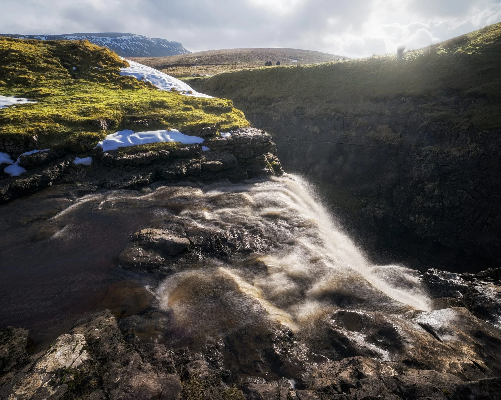
We clambered as close to the waterfall as possible as it crashed over the edge into Hull Pot. As I had no tripod, I shot this with my ultra-wide 14mm at f/22, taking multiple exposures of the same scene. In post, I then averaged the exposures together that gave me that long exposure effect on the water.
Looking up Hull Pot Beck and its many cascades. By the normal way of things, this beck is dry as it usually disappears into the maze of caves beneath Pen-y-Ghent before it reaches Hull Pot. With all the rain and snow we’ve had, the beck was able to complete its route, crashing 60ft down into Hull Pot and re-emerging at the surface nearer Horton-in-Ribblesdale.
A different view of Hull Pot from its eastern end. Two boulders balance precariously on the lip of the pot.
At around 450 m/1,476 ft above sea level, a few snow patches have lingered around the edges of Hull Pot, allowing for some interesting compositional leading lines.
A particularly clean snow patch nearer the falls gives me an idea for a composition involving Pen-y-Ghent in the distance. Fellow hikers milling about the edge of Hull Pot give you a sense of scale of this place.
Heading back down to the village, signs were clear that the best of the day’s light were done as the storm clouds rolled in. We were thankful to get what we did, though.
Did you enjoy these photos?

Grasmere, Lake District, Winter
The winter lurgy has struck.
The winter lurgy has struck.
Following a lovely hike around Ambleside, Lisabet came down with a rather nasty cold and I followed suit soon after.
We’re both at the tail end of this bug now, but with depleted energy levels as can be expected. A crisp, clear, and super cold Sunday greeted us, so we set off towards the impossibly bonny village of Grasmere for a wee waltz around the area.
All photos shot on my Sony α7ii using my Pentax SMC 28mm F3.5 and Pentax SMC 55mm f2.0 prime lenses. RAWs developed in Lightroom and edited in Photoshop.
Grasmere, Lake District, Winter by Ian Cylkowski is licensed under CC BY-NC-SA 4.0![]()
![]()
![]()
![]()
The trail in the direction of Allan Bank enjoys wonderful views towards Helm Crag and Seat Sandal. Here, the latter of the two fells is stroked by golden afternoon light across its flanks.
Across the vale, the craggier yet smaller Helm Crag receives similar treatment from the emerging winter sun.
Heading down the hill towards Goody Bridge, the snowcapped Great Rigg on the right is illuminated. Love the rusty colours some of the Lake District and Scottish fells turn in the autumn and winter.
Expansive views from the Allan Bank trail lead to Seat Sandal being bathed in afternoon winter sun.
A timeless route back to the village centre. There’s no need to hurry.
Did you enjoy these photos?

Ambleside, Lake District, Winter
Temperatures have plunged.
Temperatures have plunged.
The nigh persistent rain of November and December has given way to a sub-zero climate and clearer conditions. Much better.
With a bright Saturday forecast, Lisabet and I ventured into the heart of the Lake District and major tourist hotspot, Ambleside. We wanted to do two walks: one, a small circular of Stock Ghyll Force, the other bigger hike up to High Sweden Bridge.
Despite being in the middle of a blisteringly cold winter in the Lake District, Ambleside was as busy as ever. This town never gets any rest.
All photos taken on my Sony α7ii using my SMC Pentax-M 28mm F3.5 and SMC Pentax-M 55mm f2.0 prime lenses, plus my Vivitar “Series 1” 70–210mm f2.8–4.0 zoom. RAWs developed in Lightroom, edited in Photoshop.
Ambleside, Lake District, Winter by Ian Cylkowski is licensed under CC BY-NC-SA 4.0![]()
![]()
![]()
![]()
A misty shot from the top of Stock Ghyll Force. Made by stacking five landscape 28mm shots, top to bottom, for a wider field of view.
The classic view of Stock Ghyll Force, currently in its more barren winter finery.
After stopping for delicious hot brews at Force Cafe, we followed the trail back down to the town. By the side of the road, this still life-esque scene revealed itself to me, and so quickly I quickly nabbed a composition.
From the town centre, it’s easy enough to find the route to the High Sweden Bridge trail. Given the direction of the low sun, we opted instead to take the trail anti-clockwise, which we’ve never done before, to get more side light.
The old packhorse bridge itself, with my Lisabet providing a nice colour contrast as she strolls across it. As I’ve mentioned on this site elsewhere, the name “High Sweden Bridge” might seem unusual, given this is located in the Lake District, England. The “sweden” aspect originally comes from the Old Norse sviðin (pronounced “swee-thin”), the past participle of svíða, meaning “to burn” or “to singe”. In this context, it refers to the clearing of land by burning.
Looking up Scandale, admiring the light beams scanning across the face of High Pike (656 m/2,152 ft).
Heading back down the higher eastern side of the Scandale valley, I equipped my 70–210mm lens for some tight and distant compositions. Fully zoomed in, I was able to pick out the mist clearing from the summits of the Langdale Pikes, on the right, and Bowfell on the left.
My 70–210mm also has a macro mode, which I used to try and capture these beautiful and tiny Cladonia pyxidata lichen.
Lake District sheep get all the best views.