
Under Loughrigg, Lake District, Winter
A brief respite amongst all the rain.
A brief respite amongst all the rain.
Despite the weather, this week has been as busy as ever. A large part of that is simply that it’s half-term for schools. Still, we figured people would be starting to head back home, so the Lake District wouldn’t be as busy.
Nope.
Our planned circuit of Grasmere was foiled due to every car park being full. Every. One.
So, change of plan. We managed to park further towards Ambleside, right next to the cricket ground, and instead do a small circuit around the Under Loughrigg area in between Ambleside and Rydal.
Still proper bonny. And, happily, signs of spring are starting to appear.
All photos taken on my Sony α7ii using my Pentax SMC 28mm F3.5 and Pentax SMC 55mm f2.0 prime lenses, plus Vivitar “Series 1” 70–210mm f2.8–4.0 zoom lens. RAWs developed in Lightroom, edited and finalised in Photoshop.
Under Loughrigg, Lake District, Winter by Ian Cylkowski is licensed under CC BY-NC-SA 4.0![]()
![]()
![]()
![]()
On the A591 between Ambleside and Rydal, one can enjoy formidable views towards Nab Scar (455 m/1,493 ft).
The flat pasture land in between Loughrigg Fell and the A591 allows for extensive views across to the surrounding fells. There were also plenty of signs of storm damage, with fallen trees and split trunks everywhere. In this case, it allowed for a nice composition towards a highlighted Low Pike (508 m/1,667 ft).
I cropped in tightly for this composition at 210mm to grab these Swaledale ewes milling around a beautiful crag, and subtle hints of the wall of Nab Scar in the background.
A surviving Scots Pine makes for a dramatic composition with the Kirkstone fells in dark shadow behind.
One of the Lake District’s well-known views, often causing sudden brakes by drivers on the A591. Looking towards Rydal, with the Kirkstone fells catching a sweeping lightbeam.
Did you like these photos?

Grasmere, Lake District, Winter
The winter lurgy has struck.
The winter lurgy has struck.
Following a lovely hike around Ambleside, Lisabet came down with a rather nasty cold and I followed suit soon after.
We’re both at the tail end of this bug now, but with depleted energy levels as can be expected. A crisp, clear, and super cold Sunday greeted us, so we set off towards the impossibly bonny village of Grasmere for a wee waltz around the area.
All photos shot on my Sony α7ii using my Pentax SMC 28mm F3.5 and Pentax SMC 55mm f2.0 prime lenses. RAWs developed in Lightroom and edited in Photoshop.
Grasmere, Lake District, Winter by Ian Cylkowski is licensed under CC BY-NC-SA 4.0![]()
![]()
![]()
![]()
The trail in the direction of Allan Bank enjoys wonderful views towards Helm Crag and Seat Sandal. Here, the latter of the two fells is stroked by golden afternoon light across its flanks.
Across the vale, the craggier yet smaller Helm Crag receives similar treatment from the emerging winter sun.
Heading down the hill towards Goody Bridge, the snowcapped Great Rigg on the right is illuminated. Love the rusty colours some of the Lake District and Scottish fells turn in the autumn and winter.
Expansive views from the Allan Bank trail lead to Seat Sandal being bathed in afternoon winter sun.
A timeless route back to the village centre. There’s no need to hurry.
Did you enjoy these photos?

Ambleside, Lake District, Winter
Temperatures have plunged.
Temperatures have plunged.
The nigh persistent rain of November and December has given way to a sub-zero climate and clearer conditions. Much better.
With a bright Saturday forecast, Lisabet and I ventured into the heart of the Lake District and major tourist hotspot, Ambleside. We wanted to do two walks: one, a small circular of Stock Ghyll Force, the other bigger hike up to High Sweden Bridge.
Despite being in the middle of a blisteringly cold winter in the Lake District, Ambleside was as busy as ever. This town never gets any rest.
All photos taken on my Sony α7ii using my SMC Pentax-M 28mm F3.5 and SMC Pentax-M 55mm f2.0 prime lenses, plus my Vivitar “Series 1” 70–210mm f2.8–4.0 zoom. RAWs developed in Lightroom, edited in Photoshop.
Ambleside, Lake District, Winter by Ian Cylkowski is licensed under CC BY-NC-SA 4.0![]()
![]()
![]()
![]()
A misty shot from the top of Stock Ghyll Force. Made by stacking five landscape 28mm shots, top to bottom, for a wider field of view.
The classic view of Stock Ghyll Force, currently in its more barren winter finery.
After stopping for delicious hot brews at Force Cafe, we followed the trail back down to the town. By the side of the road, this still life-esque scene revealed itself to me, and so quickly I quickly nabbed a composition.
From the town centre, it’s easy enough to find the route to the High Sweden Bridge trail. Given the direction of the low sun, we opted instead to take the trail anti-clockwise, which we’ve never done before, to get more side light.
The old packhorse bridge itself, with my Lisabet providing a nice colour contrast as she strolls across it. As I’ve mentioned on this site elsewhere, the name “High Sweden Bridge” might seem unusual, given this is located in the Lake District, England. The “sweden” aspect originally comes from the Old Norse sviðin (pronounced “swee-thin”), the past participle of svíða, meaning “to burn” or “to singe”. In this context, it refers to the clearing of land by burning.
Looking up Scandale, admiring the light beams scanning across the face of High Pike (656 m/2,152 ft).
Heading back down the higher eastern side of the Scandale valley, I equipped my 70–210mm lens for some tight and distant compositions. Fully zoomed in, I was able to pick out the mist clearing from the summits of the Langdale Pikes, on the right, and Bowfell on the left.
My 70–210mm also has a macro mode, which I used to try and capture these beautiful and tiny Cladonia pyxidata lichen.
Lake District sheep get all the best views.
Did you enjoy these photos?

Grisedale, Lake District, Winter
Happy New Year, everyone! Here’s to a peaceful and gentler 2024.
Happy New Year, everyone! Here’s to a more peaceful and gentle 2024.
Though I’ve enjoyed time off work between Christmas and New Year, it’s not exactly been pleasant. Storm Gerrit washed across the UK, rendering most days miserably wet. There were even tornado warnings, largely unheard of in the UK.
On New Year’s Eve we learned that New Year’s Day promised much nicer conditions, and so we endeavoured to rise early and head into the Lake District for a solid yomp on the first day of 2024.
Conditions were certainly nicer, though you can never predict weather in the Lake District 100%. Hiking along the valley bottom of Grisedale towards the valley’s head, we were washed with wave after wave of fine drizzle. Thankfully, it never rained that hard, and in between the downpours we still managed to nab some glorious photos.
All photos taken on my Sony α7ii using my Pentax SMC 28mm F3.5 and Pentax SMC 55mm f2.0 prime lenses. RAWs developed in Lightroom using RNI Films’ Kodachrome film profiles, finalised in Photoshop.
Grisedale, Lake District, Winter by Ian Cylkowski is licensed under CC BY-NC-SA 4.0![]()
![]()
![]()
![]()
A sign of things to come. St. Sunday Crag (841 m/2,759 ft), rising above a sodden landscape with stormy clouds above.

Much of the first half of hiking into the valley comprised of dodging waves of drizzle. When one cleared up for long enough, I snuck this shot of Eagle Crag and Dollywaggon Pike (858 m/2,815 ft) battling with the low clouds.
Arriving closer to the turning point, we contemplated the condition of the trail on the other side of the valley. The hike in, on the south of the valley, is thankfully paved but had still been rendered in parts as a beck due to all the rain. I knew that the northern path back down the valley wasn’t in as good nick. So, from here, we turned back the same way we came in.
Thankfully, this was also when conditions started to clear up and the Helvellyn range of fells began to reveal themselves.
Eagle Crag with Nethermostcove Beck roaring down the fellside. A project was started in 2021 to return the valley’s main river, Grisedale Beck, back to its original “wiggly” form. To quote the Friends of the Ullswater Way: “As with many rivers in the UK, Grisedale Beck has historically been straightened and reinforced so that fields can be drained to improve grazing. This work was undertaken over 200 years ago and since then we have learned a lot about how straightened and reinforced rivers can negatively affect wildlife and increase flood risk. It should be noted that, despite the historic changes made to the river at the project site, this is still not particularly good grazing land, being very rough pasture and quite boggy in areas.”
Heading back down the valley, we kept turning back at the beautiful view at the head of Grisedale. Primarily to check on any incoming rain washing over the fells, but also to gawp at them. I enjoyed this composition as the trail seemingly leads across the image towards Nethermostcove Beck on the right. Pure mood.
One of the few pines left in the valley points a vibrant branch towards the beautifully cracked glacial erratic.
As the cloud cover finally starts to lift, Falcon Crag and Tarn Crag emerge from behind Dollywaggon Pike.
Light finally breaks through the clouds as we retreat further down the valley.
The beck streaming down from Blind Cove provides a nice leading line towards the vertical face of St. Sunday Crag.

The fells become obscured again. Another wave of rain heads towards us.
As another squall washes over us, I look across to the northern side of Grisedale and spot these bright becks cascading down the fellside. I very quickly nab a photo.
Soon, we near the foot of the valley and the rains were finally done for the afternoon. Look at that mountain backdrop.
Heading back towards the car, the hulking mound of Place Fell catches the warm winter light across its crags.
We elected for the scenic route back to Kendal, heading north out of Patterdale, through Matterdale, and onto the A65. That way we could turn off to head down St. John’s in the Vale and join the A591 back to Kendal. I kept my camera out, with the 55m attached to it, and grabbed this epic scene of Blencathra from the passenger’s side.
Down St. John’s in the Vale, I kept snapping happily, praying that at least one of the shots rendered sharp. Here, the deep cleft of Beckthorns Gill cuts into various crags of Clough Head.
Further south on the A591, near Thirlmere, Fisherplace Gill cuts a deep fissure within the crags of the Helvellyn massif. The farmhouses below look miniscule in comparison.
The distinctive shape of Browncove Crags, a subsidiary top of Helvellyn, with another deep gill caused by Helvellyn Gill.
Did you enjoy these photos?
Ulverston, Cumbria, Winter
It’s been a while since my last post.
It’s been a while since my last post.
Apologies.
I hope every one has had a nice and/or peaceful Christmas.
Following the arctic blast at the beginning of December, the UK has been wet. Two storms washed over the British Isles—Elin and Fergus—bringing with them intense winds and lots of rain.
Being in Cumbria, we got the bulk of the rain.
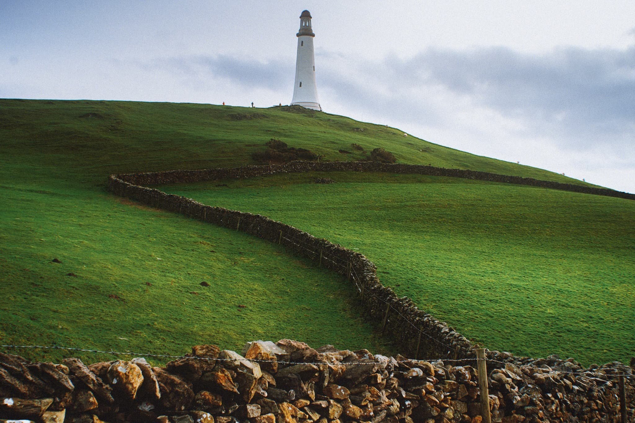
Finally, on Boxing Day, clear skies and cool temperatures greeted us. We immediately donned gear and head out to the Furness Peninsula of Cumbria. It was time to hike up the Hoad above Ulverston.
It felt good to finally get out and about.
All photos taken on my Sony α7ii, using my Pentax SMC 28mm F3.5 and Pentax SMC 55mm f2.0 prime lenses, plus my Vivitar “Series 1” 70–210mm f2.8–4.0 zoom lenses. RAW images edited in Lightroom using RNI Films’ Kodachrome film profiles, finalised in Photoshop.
Ulverston, Winter, Cumbria by Ian Cylkowski is licensed under CC BY-NC-SA 4.0![]()
![]()
![]()
![]()
Locating the path from Ford Park, we followed it gently up towards the Hoad. Along the way, this group of trees presented a wonderful framing composition of the Hoad.
The trail quickly grew steeper, which also provided fantastic views. From the shoulder of Hoad Hill, the wet autumn and December are evident in the flooded fields near the coast of the Leven Estuary.
Near the top of the hill, as the trail levelled out, we could start making out the Lakeland fells above the Furness hills. The particularly rounded fell centre-right is Wetherlam (763 m/2,502 ft).
Near the monument, outcrops of Bannisdale Slate gave me a wonderful opportunity for some compositions involving the Hoad.
The Hoad goes by a few names. It’s officially known as the Sir John Barrow Monument, but is also known locally as “the Pepperpot”.
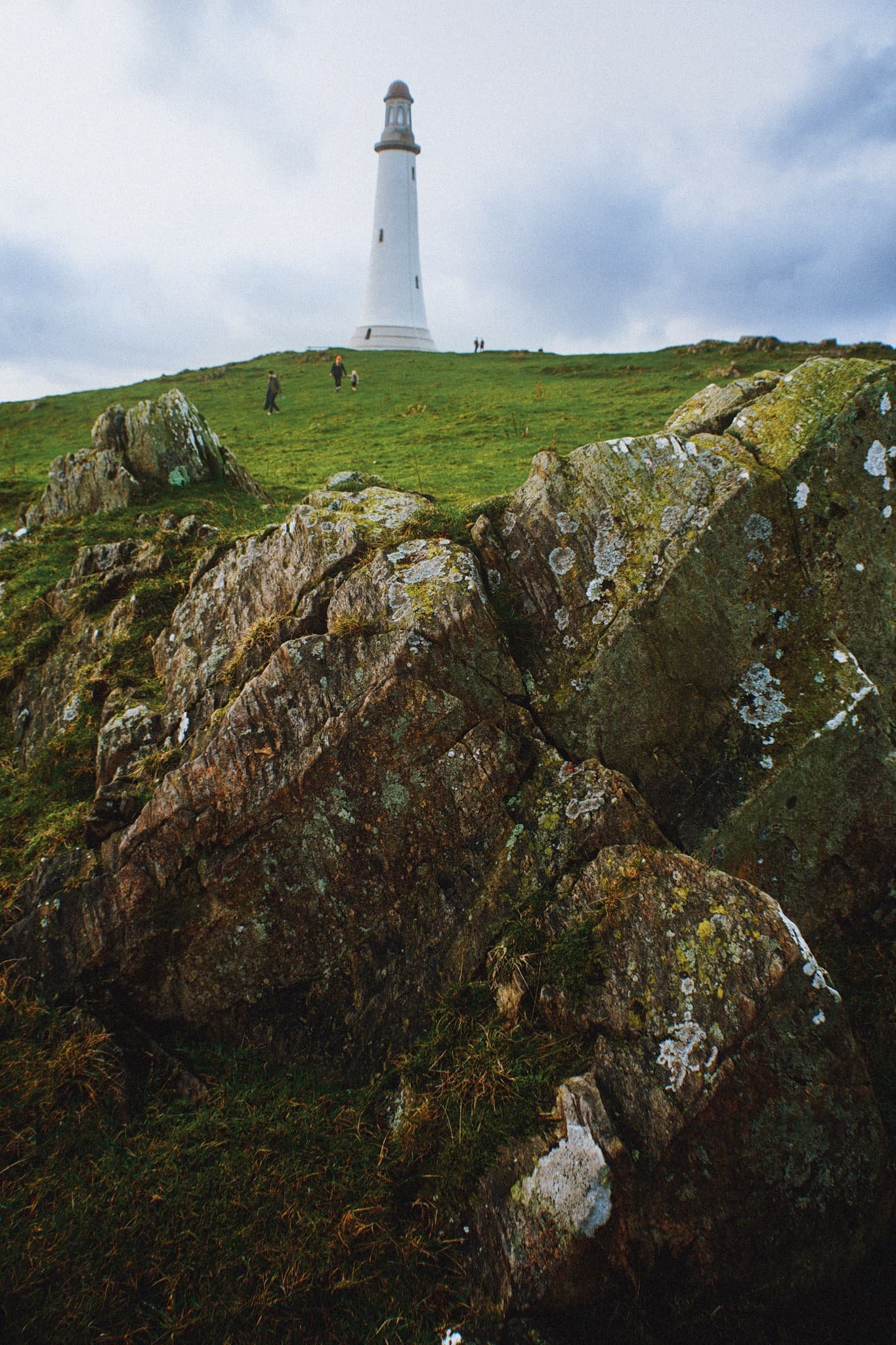
The Hoad was built in 1850 at a cost of £1,250, roughly £138,000 in today’s money. It was built to commemorate Sir John Barrow, who was a founding member of the Royal Geographical Society, and born in Ulverston. Though it looks like a lighthouse, it has never functioned as one.

The views from the Hoad are extensive and panoramic. Plenty of folk were out and about, enjoying a Boxing Day waltz and soaking in the views from the Hoad.
With my 70–210 mm equipped, I was able to pick small sections of Ulverston town. Here, looking southwest from the Hoad, the winding A590 road provides a focal point for the busy architectural landscape of Ulverston.
The view north from the Hoad couldn’t be more different. Rolling countryside, drystone walls, and sheep give way to the mighty Coniston Fells.
Northeast of Hoad Hill, another small hill provides sustenance to yet more sheep. In the distance, the Windermere fells partially obscure the Kentmere fells.
The way back to Ulverston town. You know me, I can’t resist a winding path.
A winding drystone wall catches my eye for a nice composition involving the Hoad.
Back in Ulverston, a wall mural tells the story of Sir John Barrow.
Did you enjoy these photos?

Appleby-in-Westmorland, Cumbria, Autumn
Here’s something a little different.
Here’s something a little different.
Every September volunteers for Heritage Open Days organise events and open up usually private buildings to celebrate the culture and heritage of England. Best of all, all of these events and visit are free.
We did some scouting on the Heritage Open Days website and found that a lot of usually closed off/private buildings in Appleby-in-Westmorland were opening up for talks and tours of these historical buildings. Armed with an ultra-wide 14mm lens and my steady 28–70mm, we set about to explore and document.
It turned out to be a fascinating morning and afternoon. Appleby-in-Westmorland is already steeped in history, and has managed to retain a lot of its architectural heritage. Being able to enter some of these buildings, some of which were 400+ years old, and document them as best I could was a joy and an honour.
All photos taken on my Sony α7ii using my Sony FE 28–70mm f3.5–5.6 OSS zoom and Rokinon 14mm f2.8 ED AS IF UMC prime lenses. RAWs developed in Capture One, then finalised in Photoshop.
Appleby-in-Westmorland, Cumbria, Autumn by Ian Cylkowski is licensed under CC BY-NC-SA 4.0![]()
![]()
![]()
![]()
This is the study room of the Colour Makers House, on High Wiend in Appleby. This building was rebuilt in 1677 CE and has the datestone to prove it. It is currently undergoing a full refurbishment.
The kitchen, retaining the original range and oven, complete with oak beams.
The building has become home to a unique Artist Colourman's Shop making pigments and paints from naturally foraged earth and rocks from Northern England. A gentleman there was demonstrating techniques used for over 4,500 years.
Inside the Council Chamber of Appleby’s Moot Hall. “Moot” comes from the Old English word mōt, meaning a meeting place. The Moot Hall was built in 1596 CE. Unlike many similar Moot Halls up and down the country, Appleby’s is rare in that it’s still used for its original purpose as a Council Chamber. The walls are lined with paintings and photos of all the mayors that have served Appleby over the centuries.
Appleby Moot Hall is also one of the earliest purpose-built Moot Halls in England. It’s had alterations made in the 18th and early-19th centuries, and was recently restored in 2022.
The Crown & Cushion, formerly listed as the Crown and Cushion Hotel and Wilson's Stores, was probably constructed from an earlier building in the mid-1700s.
The way to St. Lawrence’s Church. It retains a significant amount of its architectural heritage, with an early 12th century foundation in addition to a reset Norman entrance and the lower parts of a defensive Norman west tower.
St. Lawrence’s Church includes a 13th-century porch, and a 14th-century nave and aisles, restored in the 17th and 18th centuries with 19th and 20th century alterations.
St. Lawrence’s bridge, built in the late 19th century to replace a much earlier structure. Every May/June Appleby sees thousands of people from the Gypsie/Traveller community, who come from all over the UK and Ireland for the Appleby Horse Fair. A custom at the Fair is to take their horses down to the Sands, pictured above, and into the River Eden where the horses are washed.
Looking up the historic Boroughgate from the near the junction with Low Wiend. Now that Sunday Service was finished, it was time to check the interior of St. Lawrence’s church.
Inside the church, medieval traceried Gothic screens with a variety of stained glass window illustrations attest to the historical interest of this building.
The nave of the church. The pews were installed in the 1700s, and the nave ceiling was plastered in the early-mid 1800s.
Ascending Boroughgate, our next stop was St. Anne’s Almshouses. Inside the courtyard we were delighted with what we found; a different world tucked away from the ongoings of the main road.
St. Anne’s Hospital was founded by Lady Anne Clifford in 1653 CE and for more than 350 years, ageing, widowed, or single ladies have lived there rent free. The upkeep of the almshouses has been paid for by Holme Farm, which was gifted by Lady Anne for the benefit of the almshouse.
There is space to the rear where the ladies were each given a strip of land on which to grow their own produce.
The grounds include a small private chapel, which retains some original 17th century fittings and wall paintings.
The coat of arms over the archway belongs to Lady Anne and her mother, and the others around the yard represent Lady Anne's noble connections.
I was amazed at how immaculately kept these 350+ year old almshouses were. A true testament to their original purpose.
In the mid-1800s, one of the houses (number six) was demolished to create a wider opening from the courtyard to the rear gardens; the former communal hall was converted to a house by way of replacement.
At the top of Boroughgate is High Cross, a 17th-century stone Tuscan column on a square base and with a square top. It bears the inscription "Retain your loyalty Preserve your rights". A windvane was added on top in 1936.
Further south from Boroughgate, beyond Appleby Castle, is Castle Bank House. Privately owned, we were allowed a wander of the grounds, stables, and art gallery. Built in the 18th century, these stables were particularly fine.
The walled garden below the house was chock full of bugs and insects enjoying all the flowers and plants.
Slap bang in the middle of the walled garden, an apple tree, brimming with fruit.
We took the minor road north east from Castle Bank House and over the River Eden via a footbridge. Halfway across the bridge, Bongate Mill caught our eye. An 18th century former corn mill.
Across the bridge and by the riverside we could see that there were river gauges. This means that, yes, you can technically ford across the river in your car to continue along the “road”. No thank you.
The appropriately named Rock Cottage, built on top of a giant crag of red sandstone.
Near the old Church Institute buildings, we spotted this wee little door built right into the sandstone crags along the road. What is it’s purpose? What is it for? Who knows?
A final shot looking down the historic Boroughgate towards St. Lawrence’s church, before making our way back to the car.